Volume 22, Issue 1 | January 2018
115
Journal of Indian Geophysical Union Editorial Board
Indian Geophysical Union Executive Council
Chief Editor P.R. Reddy (Geosciences), Hyderabad
President Prof. Shailesh Nayak, Distinguished Scientist, MoES, New Delhi
Associate Editors B.V.S. Murthy (Exploration Geophysics), Hyderabad D. Srinagesh (Seismology), Hyderabad Nandini Nagarajan (Geomagnetism & MT), Hyderabad M.R.K. Prabhakara Rao (Ground Water Geophysics), Hyderabad
Vice-Presidents Dr. Satheesh C. Shenoi, Director, INCOIS, Hyderabad Prof. Talat Ahmad, VC, JMI, New Delhi Dr. V.M. Tiwari, Director, CSIR-NGRI, Hyderabad Dr. Sunil K. Singh, Director, CSIR-NIO, Goa
Editorial Team
Hon. Secretary Dr. Kalachand Sain, CSIR-NGRI, Hyderabad
Solid Earth Geosciences: Vineet Gahlaut (Seismology), New Delhi B. Venkateswara Rao (Water resources Management), Hyderabad N.V. Chalapathi Rao (Geology, Geochemistry & Geochronology), Varanasi V.V. Sesha Sai (Geology & Geochemistry), Hyderabad Marine Geosciences: K.S.R. Murthy (Marine Geophysics), Visakhapatnam M.V. Ramana (Marine Geophysics), Goa Rajiv Nigam (Marine Geology), Goa Atmospheric and Space Sciences: Ajit Tyagi (Atmospheric Technology), New Delhi Umesh Kulshrestha (Atmospheric Sciences), New Delhi P. Sanjeeva Rao (Agrometeorology & Climatoplogy), New Delhi U.S. De (Meteorology), Pune Archana Bhattacharya (Space Sciences), Mumbai Editorial Advisory Committee: Walter D Mooney (Seismology & Natural Hazards), USA Manik Talwani (Marine Geosciences), USA T.M. Mahadevan (DeepContinentalStudies&MineralExploration),Ernakulum D.N. Avasthi (Petroleum Geophysics), New Delhi Larry D Brown (Atmospheric Sciences & Seismology), USA Alfred Kroener (Geochronology & Geology), Germany Irina Artemieva (Lithospheric Structure), Denmark R.N. Singh (Theoretical& Environmental Geophysics), Ahmedabad Rufus D Catchings (Near Surface Geophysics), USA Surjalal Sharma (Atmospheric Sciences), USA H.J. Kumpel (Geosciences, App.Geophyscis, Theory of Poroelasticity), Germany Saulwood Lin (Oceanography), Taiwan Jong-Hwa Chun (Petroleum Geosciences), South Korea Xiujuan Wang (Marine Geology & Environment), China Jiro Nagao (Marine Energy and Environment), Japan Information & Communication: B.M. Khanna (Library Sciences), Hyderabad
Joint Secretary Dr. O.P. Mishra, MoES, New Delhi Org. Secretary Dr. ASSSRS Prasad, CSIR-NGRI, Hyderabad Treasurer Md. Rafique Attar, CSIR-NGRI, Hyderabad Members Prof. Rima Chatterjee, ISM, Dhanbad Prof. P. Rama Rao, Andhra Univ., Visakhapatnam Prof. S.S. Teotia, Kurukshetra Univ., Kurukshetra Mr. V. Rama Murty, GSI, Hyderabad Prof. B. Madhusudan Rao, Osmania Univ., Hyderabad Prof. R.K. Mall, BHU, Varanasi Dr. A.K. Chaturvedi, AMD, Hyderabad Mr. Sanjay Jha, Omni Info, NOIDA Mr. P.H. Mane, ONGC, Mumbai Dr. Rahul Dasgupta, OIL, NOIDA Dr. M. Ravi Kumar, ISR, Gujarat Prof. Surjalal Sharma, Univ. of Maryland, USA Dr. P. Sanjeeva Rao, Advisor, SERB, DST, New Delhi Dr. N. Satyavani, CSIR-NGRI, Hyderabad Prof. Devesh Walia, North Eastern Hills Univ., Shillong
EDITORIAL OFFICE Indian Geophysical Union, NGRI Campus, Uppal Road, Hyderabad- 500 007 Telephone: +91 -40-27012799; 27012734; Telefax:+91-04-27171564 E. mail:
[email protected], website: www.j-igu.in The Open Access Journal with six issues in a year publishes articles covering Solid Earth Geosciences; Marine Geosciences; and Atmospheric, Space and Planetary Sciences.
Annual Subscription Individual ` 1000 per issue and Institutional ` 5000 for six issues Payments should be sent by DD drawn in favour of “The Treasurer, Indian Geophysical Union”, payable at Hyderabad, Money Transfer/NEFT/RTGS (Inter-Bank Transfer), Treasurer, Indian Geophysical Union, State Bank of India, Habsiguda Branch, Habsiguda, Uppal Road, Hyderabad- 500 007 A/C: 52191021424, IFSC Code: SBIN0020087, MICR Code: 500002318, SWIFT Code: SBININBBHO9. For correspondence, please contact, Hon. Secretary, Indian Geophysical Union, NGRI Campus, Uppal Road, Hyderabad - 500 007, India; Email:
[email protected]; Ph: 040 27012799, 272012734
ISSN: 0257-7968 (Clarivate Analytics) ISSN: 0971-9709 (NISCAIR) Approved as bimonthly ESCI journal by Clarivate Analytics Cited in Indian Citation Index (ICI), New Delhi Recognized by UGC Evaluated by NISCAIR, New Delhi
Contents Editorial S No.
Title
Authors
1
My fifty years of adventures measuring gravity and gravity gradients at sea, In airplanes, and by astronauts, on the moon
Manik Talwani
7
2
Study of 2D basins and site-city interaction effects on ground motion characteristics
Neeraj Kumar and J.P. Narayan
16
3
A new Approach for Residual Gravity Anomalies Interpretations: Artificial Bee colony Optimization Algorithm
Ahmad Alvandi
24
4
Application of Electrical Resistivity Imaging in investigation of Late Maastrichtian coal seam at Amoso Edda/Owutu Edda environs, Anambra Basin, Nigeria
Falae Philips
32
5
Spatial mapping of aquifer parameters over basaltic aquifers of Maharashtra(India) using geophysical and hydro-geochemical information
G. Shailaja, Gautam Gupta and P. Rama Rao
40
6
Locating Center of pressure in 2D geological situations
Soumyajit Mukherjee
49
7
Relative Index of Seismic Hazard (RISH) and it’s implication in first order seismic hazard assessment of Sabarmati River Basin, Gujarat, India
R.K. Dubey, Vinay K. Dwivedi, Vasu Pancholi and B.K. Rastogi
52
8
On the global aspects of the almostantipodal symmetry on the Earth
Kovalyov, Mikhail
60
9
Temporal variation of carbon dioxide and water vapour density over a station in west coast of Arabian Sea during sea breeze and land breeze
T. Dharmaraj, M.N. Patil, Cini Sukumaran, B.S.Murthy, G.R. Chintalu, E. Chandrasekar, M. Rajendran, and Devendraa Singh
66
10
Forecasting rainfall trend over Tamil Nadu during northeast monsoon
Vinod Kumar, M. Satya Kumar and K. S. Hosalikar
79
11
2016 southwest monsoon and its long range forecast
Onkari Prasad, O.P. Singh and K. Prasad
90
12
Irrigation in India and needed strategies for sustainable Development
P.R. Reddy
101
News at a glance
Pg. No:
110
This is an open access Journal. One can freely DOWNLOAD contents from: Website: www.j-igu.in
Editorial As I started writing this editorial both Navaratri and Deepavali festivals have been celebrated in the usual way. They made me nostalgic. I was always benefitted by the stories told by my mother about the victory of good over the bad. The 9 day festival urges mankind in general and the educated in particular to wake up from slumber of ignorance, remove all negativity, cleanse the mind and nurture positive values to help the needy in every respect to overcome many hassles to lead a decent life. The Deepavali festival reminded us about the necessity to drive away darkness from our lives and lives of many deserving human beings. As I was worrying about the amount of pollution created by fire crackers I was thrilled to see a photo of the Golden temple at Amritsar. Without polluting the environment every one enjoyed Deepavali looking at the sky glittering with thousands of flying lights. We can follow this tradition and help one and all enjoy Deepavali. 2017 in many ways destroyed the serene atmosphere due to ever increasing misery all over the world due to Nature`s fury and overambitious behaviour of Men in power. The powerful leaders of developed countries have no interest in seeing the world full of ever smiling Human beings, in place of ever suffering millions. The series of traumatizing natural and human induced impacts have significantly affected everyone in one way or the other. The traumatising effect should not lead to irrational acts destroying the human race much before the natural catastrophes. Irrespective of threatening dark clouds we have to optimistically look forward to a ray of hope. I wish you all a Happy New Year and a Prosperous 2018. I also wish you bountiful of happiness on “Makara Sankranti”. It is the last but one editorial by me before retiring by the end of March , as the two year term of present editorial board ends on 31st March, 2018.I am fortunate to have the full support of the editorial board, which helped me to introduce ongoing research initiatives in different parts of the earth and useful news items, in addition to reasonably interesting and good research studies, which helped the young researchers to have an overall comprehension of various facets of research covering all the branches of earth system. I am happy to learn from some distinguished senior scientists that they enjoyed reading articles published in JIGU, starting from “Editorial” and ending with “News at a Glance”.
Fury of Nature: It is time to pool up our energies to have a more focused approach to understand the might of Nature and reorient our strategies to better align with Nature to overcome series of setbacks faced by us due to the fury let out by Nature. After total solar eclipse in August, 2017 and enhanced solar flares some believers in the might of Nature pointed out that we might face enhanced fury due to disturbed balance between atmosphere, oceans and solid earth. Since the total solar eclipse was witnessed only in USA and some of the Caribbean islands the believers in planetary congregation strength mentioned about negative impact to USA and surroundings. After seeing the catastrophic devastation caused by Harvey and Irma hurricanes to Caribbean islands, Cuba, Houston, Florida and surroundings of U.S.A learned weather experts have pointed out “Hurricane Harvey and Irma reminded us just how vulnerable are those residing in low-lying cities like Houston & Florida and chain of Caribbean islands and Cuba in a climate-changed world – especially when we degrade the living ecosystems that regulate floods and absorb greenhouse gasses.”Grade 4 Harvey and grade 5 Irma with winds crossing 250 km/ hr dumped in few hours rain water crossing 550 to 600 mm all along their paths of travel causing immeasurable damage to men and material. One of the Eos staff editors based in Houston chronicled her horrendous day by day experiences, starting from 25th August and ending on 6th September. Some details are given below. She pointed out “As geoscientists, we know well the power of water. We harness energy from it. It nourishes our crops. It fuels civilizations. We use its flow to connect goods and services across the planet. It brings our planet life. These days, it’s the Holy Grail in the search for life beyond our planet. But water has a dark side that geoscientists also know well. Its force can carve canyons and topple dams. It makes volcanoes explosive. It lubricates landslides. It swells rivers and floods homes. Within it, disease festers. It’s one thing to know about the power of water. It’s another thing to see it firsthand. “Acts of God.” “Mother Nature’s fury.” These terms have value when learned discuss hazard— the strength of the winds at landfall, the unprecedented amount of rain dumped on southeast Texas. Fifty inches fell in some places over the course of the storm. I’ve seen graphics that show the total water unleashed in terms of a
volume above ground, I’ve read comparisons that give the amount of rainfall as one sixth the volume of Lake Erie. I’m trained as a geoscientist, and I know that more is needed to turn an event into a disaster. That something extra is risk. Risk is where the population interfaces with the hazard. Behaviors and our built environment can exacerbate or lessen that risk. How do I tell my 5 year son and 2 year daughter that their daddy and mummy, with our geoscience degrees and jargon-filled theses, now wonder what all those years of study were for if we’re not answering questions that can help save lives? And that even if science does have answers the flow of information to policy makers and to people on the ground is far from watertight? I’ll start with the basics. I’ll tell them that water brings life. But it also has a dark side.” (Source: Some excerpts from; Kumar, M. (2017), A diary of a storm, Eos, 98, https://doi.org/10.1029/2017EO081385. Published on 07 September 2017.). WMO Expert Team on Climate Impacts on Tropical Cyclones issued a statement on possible linkages between Hurricane Harvey and anthropogenic climate change. They have mentioned that “Model simulations also indicate that hurricanes in a warmer climate are likely to become more intense, and that it is more likely than not that the frequency of category 4 hurricanes will increase over the 21st century, even if overall tropical cyclone numbers do not increase. Such changes are not yet clearly detectable in observed data due in part to limitations of existing datasets. Ongoing sea-level rise, attributable in part to anthropogenic climate change, also exacerbates storm surge for landfalling hurricanes such as Harvey. Damage resulting from the geophysical event itself will be influenced by the vulnerability of the affected region, which is increased by factors such as population and infrastructure growth, and potentially decreased by mitigation measures such as flood control systems. Extensive coastal development has generally led to large increases in hurricane damage in U.S. coastal communities over the past century.” If Harvey`s devastation was horrendous the devastation caused by hurricane Irma was nothing but hell. The fury of Irma was at least three fold stronger compared to Harvey. Hurricane Irma caused devastation in low-lying Caribbean islands, made landfall in Cuba as the first category 5 hurricane since 1924 and made landfall again in Florida, USA, on 10th September as a very dangerous category 4 hurricane on the Saffir-Simpson windscale. The US National Weather Service and US National Hurricane Center warned of life-threatening storm surge, floods, tropical storm force winds, torrential rain and tornadoes as large parts of Florida were paralysed by the storm.
As millions of battered residents of Caribbean islands were reeling from the after effects of Irma, hurricane Maria started pummelling Puerto Rico on 19th September bringing “catastrophic” 155mph winds and dangerous storm surges, after battering the Virgin Islands. The “monster” storm is one of the strongest to ever hit the US territory, with warnings that heavy rain could cause landslides and storm surges of up to 9ft that risk swamping low-lying areas. Describing the storm as “potentially catastrophic”, the US National Hurricane Centre said: “Some fluctuations in intensity are likely during the next day or two, but Maria is forecast to remain an extremely dangerous category four or five hurricane until it moves near or over the Virgin Islands and Puerto Rico.” Fortunately Hurricane Jose, which developed prior to Maria spared Caribbean Isles and hit eastern states of mainland USA, with reduced intensity. Studying these chain of hurricanes Harvey, Irma, Jose and Maria the climate experts have stated that occurrence of such a cluster of hurricanes is not simply coincidenceinstead, it is a demonstration of global warming in action. They also warned that the response to these hurricanes shows how terrifying unprepared the world is for the kind of extreme weather events that will become more and more common as the Earth gets hotter. (Sources:https://public.wmo.int/en/media/.../hurricaneirma-causes-devastation-breaks-records & www.telegraph. co.uk › News; https://en.wikipedia.org/wiki/Hurricane_ Jose_(2017);http://www.independent.co.uk/environment/ hurricane-irma-harvey-jose-climate-change-proof-real-getworse-florida-texas-houston-global-warming-a7941501. html ). As I have been pondering about the ill luck of residents of Caribbean islands I have come across a scientific article. A research study states that while strong seasonal hurricanes have devastated many of the Caribbean and Bahamian islands in 2017, geologic studies on several of these islands illustrate that more extreme conditions existed in the past. A new analysis published in Marine Geology shows that the limestone islands of the Bahamas and Bermuda {Bermuda Triangle area} experienced climate changes that were even more extreme than historical events. In the interest of our future world, scientists must seek to understand the complexities of linked natural events and field observations that are revealed in the geological record of past warmer climates. Hearty and Tormey(2017) state “Our global society is producing a climate system that is racing forward out of humanity’s control into an uncertain future. If we seek to understand the non-anthropogenic events of the last interglaciation, some of the consequences
of our unchecked forward speed may come more clearly into focus...a message from the past; a glimpse into the future.” (Source: P.J. Hearty, B.R. Tormey. Sea-level change and superstorms; geologic evidence from the last interglacial (MIS 5e) in the Bahamas and Bermuda offers ominous prospects for a warming Earth. Marine Geology, 2017; 390: 347 DOI: 10.1016/j.margeo.2017.05.009).The information given by the two scientists has dampened my spirits to a considerable extent. Having gone through these details and seen TV pictures I am convinced that all of us, who boast ourselves as cutting edge scientists should first behave like any other normal human being to understand the misery faced by millions of sufferers due to natural hazards and disasters and empathise with them. Natural disasters bring out the best and worst in people. There are some who race to the rescue of people they don’t even know. They are our everyday heroes. Men and women who see a need and just go do something to help. I love these people. We all do. It builds my faith in the goodness of people. There are still lots of good people on planet Earth. Then there are others who take advantage of a bad situation; the liars, cheaters, and thieves. Some people see a disaster as a quick way to take advantage of people in distress. Be wise my friends. Disasters bring out the best and the worst of people. As pointed out by Ralph Waldo Emerson “The purpose of life is not to be happy. It is to be useful, to be honorable, to be compassionate, and to have it make some difference that you have lived and lived well.” Our role as fellow citizens of millions: Millions are forced to suffer year after year from devastating floods in north and north east India and tropical cyclones that are regularly battering our coastal corridor. To provide on spot answers to many routine problems it is time to divert at least 30% of research activity in addressing problems faced by the common man. Let us set aside our myopic view on low end research activities that are helping in one way or the other our hapless fellow citizens who are suffering from natural hazards. Even though these research initiatives may be routine in nature they are useful in solving many area specific problems. I urge heads of reputed research organisations to encourage those associated with water, pollution, irrigation, agriculture, safety of our coastal corridor, monsoon activities, sustainable and resilience
measures to strengthen post disaster mitigation measures and allow them to publish their results in journals like our own JIGU( which has already attracted the attention of reputed organisations like University Grants Commission and many state government research centres).If there is no change in our outlook towards the field oriented area specific routine research activities we may have to suffer for want of useful data to understand area specific changes with time, as those useful results usually end up as less important institute reports. At that time models developed using sophisticated soft ware would be of no use, as the basic objective in developing those models is entirely different. I am not against cutting edge scientific research and publication of research results in highly cited reputed journals, as those publications encourage researchers to do more to go up the ladder. I am only requesting various selection committees and heads of research organisations to give equal importance to research initiatives that benefit our society. Since these studies are of local importance reputed international journals usually refuse to publish those studies. As detailed above such studies can be published in our own journals, which have reached a stage that is given due weightage by researchers and accreditation channels. In this Issue: This issue has twelve research articles, an “editorial” and “News at a Glance”. I do reiterate that the significant efforts made by a large number of learned editorial board members, starting from 1997, has helped us to enhance quality of the journal step by step. All of them, including myself, are aware that lot more has to be done following ethical standards to make the journal a reputed one. I am of the opinion that we have achieved reasonable success in spite of limited support from well known research organizations. I thank profusely different universities and couple of well established research organizations for extending needed support by encouraging their employees to contribute articles to JIGU. I do hope other organizations will also encourage their scientists and technical experts to publish in JIGU. Such a support will help our Indian journals (like JIGU) to prosper and serve young researchers of our country in publishing their studies without any hindrance. I profusely thank university grants commission (UGC) for recognising our journal. I thank one and all for their continued support to JIGU. P.R.Reddy
Quotes on Hurricanes
*“He knew too what it was to live through a hurricane with the other people of the island and the bond that the hurricane made between all people who had been through it. He also knew that hurricanes could be so bad that nothing could live through them.” -Ernest Hemingway (1899-1961) was an American novelist, short story writer, and journalist. *** * “Anyone who says they’re not afraid at the time of a hurricane is either a fool or a liar, or a little bit of both.” -Anderson Cooper (1967--) is an American journalist, television personality, and author. *** *“Demons never die quietly, and a week ago the storm was a proper demon, sweeping through the Caribbean after her long ocean crossing from Africa, a category five when she finally came ashore at San Juan before moving on to Santo Domingo and then Cuba and Florida. But now she’s grown very old, as her kind measures age, and these are her death throes. So she holds tightly to this night, hanging on with the desperate fury of any dying thing, any dying thing that might once have thought itself invincible.” - Caitlín R. Kiernan (1964--) is an Irish-born American author of science fiction and dark fantasy works. *** *“Some people can find peace in the middle of a hurricane; that’s the person I’m striving to be.” -Stephen F. Campbell (1962--) Managing Director and Head of Credit Strategy, Annaly Capital Management. *** * “Through meteorology, we know essentially how hurricanes form, even though we can’t say where the next storm will arise.” -Eric Maskin (1950--) is an American economist and 2007 Nobel laureate *** * “I think the Caribbean countries face rising oceans and they face increase in the severity of hurricanes. This is something that is very, very scary to all of us. The island states in the world represent - I remember this number - one-half of 1 percent of the carbon emissions in the world. And they will - some of them will disappear.” -Steven Chu (1948--) is an American physicist, known for his research at Bell Labs and Stanford University *** * “Hurricane season brings a humbling reminder that, despite our technologies, most of nature remains unpredictable.” -Diane Ackerman (1948--) is an American poet, essayist, and naturalist. *** * “It was like being in the eye of a hurricane. You’d wake up in a concert and think, Wow, how did I get here? -John Lennon (1940-1980) was an English singer, who co-founded the Beatles. *** * “Despite the fact we give hurricanes names like Katrina and Rita, a hurricane isn’t a self-contained unit. A hurricane is an impermanent, ever-changing phenomenon arising out of a particular set of interacting conditions - air pressure, ground temperature, humidity, wind and so on. The same applies to us: we aren’t self-contained units either. Like weather patterns, we are also an impermanent, ever-changing phenomenon arising out of a particular set of interacting conditions. Without food, water, air and shelter, we’d be dead. Without our genes,
J. Ind. Geophys. Union ( January My 2018 ) Years of Adventures Measuring Gravity and Gravity Gradients at Sea, Fifty v.22, no.1, pp: 7-15 In Airplanes, and by Astronauts, on the Moon
My Fifty Years of Adventures Measuring Gravity and Gravity Gradients at Sea, In Airplanes, and by Astronauts, on the Moon Manik Talwani Rice University, Department of Earth Science-MS 126 Houston,Texas, 77005, U.S.A *Corresponding Author:
[email protected]
Abstract
Gravity measurements that generally require an accuracy of 1 milligal for regional studies and often 0.1 milligal for commercial investigations in the presence of Earth’s gravity of about 980,000 mgal are difficult to start with, even using apparatus placed on a fixed horizontal plane (1 milligal or mgal = .001cm/sec2). Moving platforms at sea, because of their obvious instability pose additional large problems in measuring gravity. Those problems and their solution are the subjects of this paper, which discusses various methods of measuring gravity at sea. I also describe how a gravity measuring instrument was constructed for use by astronauts on the moon. A particular emphasis is placed on how the errors in measurements caused by horizontal accelerations on moving vehicles were determined and eliminated. Finally, an instrument for measuring gravity gradients in airplanes, and its application in a survey are described. Key words: Gravity and Gravity gradients, Moving platforms, Gravity measuring instruments, horizontal accelerations
INTRODUCTION AND AUTHOR’S CONTRIBUTIONS The main purpose of this paper is to follow the evolution of marine gravity measurements from measuring in shallow water by placing the gravimeter on a solid sea bottom, to measurements in a submarine and on to a surface ship. Building a gravity measuring system to be used on the moon and making measurements of gravity gradients in an airplane are also described. This is in part a personal journal and it describes the author’s role both in making measurements in some cases and in other cases dealing with errors and constructing instrumentation to make the appropriate corrections. No gravity measurements are unique, and in this paper I subjectively describe and emphasize the role I played in making measurements and in devising instrumentation to correct instrumental errors. Thus, the measurements I made on a submarine were the last measurements made with the Vening Meinsz apparatus and the first in the Western Indian Ocean. I also developed the Cross Coupling computer to correct a serious error in the Graf Askania gravimeter and I was fortunate to be selected the Principal Investigator for the lunar gravity experiment. The airborne gravity gradiometer measurements on the San Andreas fault zone that I arranged are one of the very few gradiometer measurements to be in the public domain.
Gravity in Shallow Waters My first introduction to measuring gravity in a marine environment was in 1956 off a fishing boat on the Bahama
banks. The gravimeter was placed in a large housing and lowered down to the shallow bottom. The water was no deeper than a few tens of feet. The gravimeter was electrically connected to controls on the boat, which allowed the gravimeter to be levelled and the measurements made on the boat. Accurate readings could be obtained and the main limitation to the method was that observations could be made only in very shallow water, where the gravimeter could be place on the solid sea bottom. To the question “instead of controlling the gravimeter from the boat, why not simplify things by putting a person in the housing and have him take the readings”, the answer was ”if he is smart enough to operate the gravimeter, he would not be stupid enough to shut himself in the housing”. The gravimeter measurements made in the Bahamas were an important part of my PhD thesis (Talwani et al., 1959).
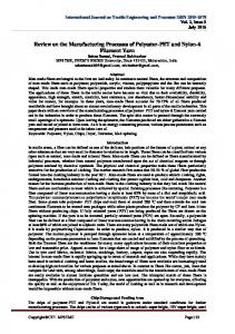
The Vening Meinsz Pendulum Apparatus in Submarines and the Browne Correction Vening Meinesz, one of the leading geophysicists of his time, was having trouble making pendulum observations to measure gravity because the ground was unstable in his native Holland, which caused errors in the measurements. So, he developed a pendulum apparatus to solve the problem and he was able to use a similar apparatus to make gravity measurements in submarines (Vening Meinesz, 1929). His was the first equipment that could be used to make measurements in deep water areas. Two innovations made these measurements possible. The first, which is the essential part of the Vening Meinesz pendulum apparatus, is that instead of using one pendulum, he used three, all
7
Manik Talwani
Figure 1. Instead of using the period of a single pendulum to obtain the value of gravity, g, Vening Meinesz suspended three pendulums from the same support. Only the two side pendulums were swung, and by obtaining the difference of motion between the side pendulums and the middle pendulum, he was able to eliminate the effect of disturbances on the side pendulums. suspended from the same support and able to swing in the same plane. The middle pendulum in Figure 1 is not made to swing. It derives its motion from the motion of the support. The pendulums on either side are made to swing in opposite directions. By an elaborate mirror arrangement, the relative motion of the side pendulums with respect to the middle pendulum is recorded and the angular displacements (θ1- θc) and (θ2- θc) are averaged to obtain θ the familiar angular displacement in the equation of motion of a pendulum (Figure 1), which, as follows, is solved to obtain the period of the pendulum t and hence the value of gravity g. First order horizontal accelerations acting on the pendulum supports are removed by taking averages of swing angles (θ1- θc) and (θ2- θc) If two pendulums of equal length are suspended from the same support and at any time have angular displacements of θ1 and θ2 , subtraction of the equations of motion gives (d2θ12/dt2- d2θ22/dt2)+(g/l)( θ1- θ2)=0, Which is solved to yield t, the time period of the so called fictitious pendulum, and is given by t=2 π (l/g)1/2, and g is thereby obtained. His second innovation was to make the measurements on submarines rather than on surface ships. At sea, the water motions on the surface are greatly reduced at depth and therefore the disturbing motions that a submarine is subjected to are much smaller than the motions that a surface ship is subjected to. This makes it easier to make the gravity measurements on a submarine. Vening Meinesz was vastly successful in making measurements in many of the world’s oceans. His measurement of the large negative gravity anomalies over the deep sea trenches in the Indonesian area was a fundamental discovery. But even great scientists sometimes make very simple mistakes, and Vening Meinesz overlooked a simple source of error. His apparatus was hung in a gimbal frame. This frame was
8
firmly attached to the submarine’s body and was subjected to the same motions as the submarine. These motions are small in a submarine but they still exist and the gimbal frame responds to them. It therefore hangs not vertically but in a direction that is the vector sum of gravity and the instantaneous horizontal accelerations. This vector sum is always positive and thus the derived value of gravity is always greater than the true value of gravity, which therefore has to be corrected. This correction is derived as follows. The quantity measured in experiment is t, the time period of the fictitious pendulum, and is given by t=2 π (l/g)1/2 But the total acceleration seen by the pendulums is not g, but is (h2+g2)1/2, (where h is the horizontal acceleration) and, which can be rewritten as g(1+h2/g2)1/2, or g+h2/2g +……, Thus –h2/2g is the Browne correction. The correction requires the knowledge of the horizontal accelerations and Vening Meinsz added a horizontal accelerometer to his apparatus to measure horizontal accelerations. It was a young graduate student Ben Browne who pointed out this error and Vening Meinesz graciously acknowledged Ben Browne’s correction as follows “The writer (Vening Meinesz) wants to pay a sincere tribute to Mr B.C. Browne who discovered several effects of the second order of the ship’s movements in the pendulum observations at sea, for which the results have to be corrected“. This was an exemplary communication from an eminent scientist to a young graduate student (Vening Meinesz, 1941). I believe I was the last person to use the Vening Meinesz apparatus on a submarine. My measurements were made on a British submarine, the H.M.S. ACHERON. We sailed from Freetown, the capital of Sierra Leone, made measurements in the Eastern Atlantic, went around the Cape of Good Hope and made measurements in the
My Fifty Years of Adventures Measuring Gravity and Gravity Gradients at Sea, In Airplanes, and by Astronauts, on the Moon
Figure 2. The beam of the Graf-Askania gravimeter is attached to a spring shown at the top of the figure, which allows it to move as gravity changes. The beam also lies in part within the pole pieces of a strong permanent magnet, which damps the motion caused by the periodic heave (vertical) accelerations, acting as a low pass filter.
Figure 3. The worst case for the Cross Coupling error occurs when the surge acceleration and the beam motion are in phase or are 180 degrees out of phase. Mozambique Channel and over the Carlsberg Ridge in the Indian Ocean to disembark in Karachi (Talwani, 1962). In a period of four months, the total number of measurements was 39. It was not a very efficient exercise.
Surface Ship Gravimeters and the Cross Coupling Conundrum In the early 1960s two surface ship gravimeters were developed, the Graf meter by Anton Graf in Germany, and the Lacoste meter by Lucian LaCoste in the USA. My colleagues and I used the Graf meter at the Lamont Doherty observatory. It is a spring gravimeter as shown in a schematic in Figure 2. The main spring at the top of the schematic is attached near the pivot point of the aluminum beam. Changes in gravity move the beam up or down. The beam motion is optically recorded and changes in beam motion yield the value of gravity. But the beam is not only subjected to the pull of gravity, it is also subjected to vertical periodic accelerations (heave). By placing the beam between the pole pieces of a permanent magnet the motion caused by the vertical accelerations is greatly attenuated. The Graf Meter is placed
on a gyro stabilized horizontal platform. It therefore stays in a horizontal position and does not swing in a gimbal frame and no Browne correction is necessary. The LaCoste meter in its early incarnation was not placed on a gyro stabilized platform, but was hung in a gimbal frame in the same manner as the Vening Meinsz pendulum apparatus. A Browne correction was therefore necessary. LaCoste was able to obtain the magnitude of the horizontal accelerations necessary for calculating the Browne correction by measuring the angle between the vertical and the appropriate direction in the gimbal frame. An accurate vertical reference was necessary for the purpose. In 1960, J.C. Harrison, a collaborator with Lacoste, published a paper (Harrison, 1960), in which he stated “ In the case of a beam gravimeter on a gyro stabilized platform, the Cross Coupling effect can contribute an error of 500 milligal, depending on the phase difference between the oscillations of the gravimeter beam and the horizontal accelerations”. This was alarming news for our group at Lamont Observatory working with the Graf (later the Graf Askania) gravimeter, and we needed to examine the situation.
9
Manik Talwani
Figure 4. The phase difference between heave and surge is shown in an actual case by constructing hodographs (plots of the two accelerations plotted against each other over a number of wave cycles).
Figure 5. The phase difference between heave and surge can also be seen by simultaneously, but separately, plotting the two accelerations for the same time interval. Also shown are beam motions and the instantaneous Cross Coupling. Top, in a following sea, bottom, sailing into the sea. First, what is the Cross Coupling effect? And how can it be corrected for? With the help of Figures 3 through 7, we explain this effect and show how it can be dealt with. In Figure 3 we explain the effect in a special idealized case. In Figures 4 and 5, we show the relationships between the relevant quantities that give rise to the Cross Coupling effect in actual cases. In Figure 6 we show how an analog Cross Coupling computer works, and in Figure 7 we show how the computed Cross Coupling is used to correct the recorded gravity signal. As seen in Figure 3 The gravimeter beam moves in response to changes in gravity, but it also moves in response to heave (vertical) accelerations. Because of heavy damping, the beam motion lags heave by 90 degrees in phase. If there is a phase difference of 90 degrees between the heave accelerations and the accelerations in the fore and aft directions (surge), the beam motions will be in phase or 180 degrees out of phase with the surge accelerations. The component of the surge accelerations at right angles to the beam will then consistently move the beam in the
10
same direction throughout the cycle of the accelerations, giving rise to the Cross Coupling effect. Figure 4 (Wall et al, 1966) shows the phase difference between heave and surge in actual cases by constructing hodographs (plots of the two accelerations plotted against each other over a number of wave cycles). A sample, when the ship was headed into the sea is seen in this figure. The heave accelerations are several times larger than the surge accelerations, and the elliptical nature of the hodograph shows that the phase difference between the two is indeed close to ninety degrees. A second way to consider the phase difference between heave and surge is to simultaneously, but separately, plot the two accelerations for the same time interval (Figure 5). Consider the bottom plot. The phase difference is a little difficult to see, but it is present. This plot also shows the beam motion which, because of the large damping, lags heave by ninety degrees and consequently is 180 degrees out of phase with surge. The Cross coupling error, which is basically the product of beam motions and surge is,
My Fifty Years of Adventures Measuring Gravity and Gravity Gradients at Sea, In Airplanes, and by Astronauts, on the Moon
Figure 6. A simplified sketch of the Cross Coupling computer.
Figure 7. Plotted time record shows how the computed Cross Coupling (top trace) when applied to the raw gravity (middle trace) can make the required correction (bottom trace). then, continuously negative. If, on the other hand, the ship is in a following sea, the phase difference between heave and surge is reversed and the Cross Coupling error is continuously positive (top plot). The finite magnitude of the Cross Coupling error in Figure 5 made it necessary to construct an analog Cross Coupling computer to determine the error in real time, and, to apply the corresponding correction. I proceeded to design and build it (Talwani et al, 1966). A simplified sketch of this computer is shown in (Figure 6). Two commercial accelerometers were used to obtain the heave and surge accelerations. The output of the heave acceleration is passed through a low pass filter (T=250 seconds) to mimic the gravimeter beam motions and then multiplied by the surge accelerations. The resultant output after being passed through the low pass filter obtains the Cross Coupling error, which can be subtracted from the raw gravity record in real time to obtain a gravity recording corrected for cross coupling. This is shown in Figure 7. The middle trace is the raw gravity record plotted against time on the moving ship (and hence against distance). The top trace is the Cross Coupling error computed by the analog computer. The very
close resemblance between the two speaks to the fidelity of the Cross Coupling correction. The bottom trace is the gravity trace corrected for Cross Coupling. To sum up, Harrison was correct in pointing out the importance of the Cross Coupling error. But though he was incorrect in estimating its magnitude, it still became necessary to construct a Cross Coupling computer to apply the correction. It is interesting to note that LaCoste gave up the practice of hanging his gravimeter in a gimbal frame and started mounting his instruments also on a gyro stabilized platform and correcting for Cross Coupling. Cross Coupling can be avoided in a number of other ways. Askania has altered its gravimeter so that the motion of the mass is only in the vertical direction and is not affected by horizontal accelerations. The “Force Balance” method is used in the Bell instrument manufactured by Bell Aerospace company, which restores the pendulum in the instrument by passing current through a coil mounted on the pendulum and placed in a magnetic field such that the current in the coil moves it to its null position. The current then gives the value of changes in the gravity field. The vibrating string method involves the measurement of
11
Manik Talwani
Figure 8. A sketch of the Bosch-Arma vibrating string instrument. The frequency difference between the two strings depends on the value of gravity, g, and on a number of constants, k1, k2, etc.
Figure 9. The astronaut about to take a gravity reading on the moon. the frequency of a vibrating string, which depends on the value of gravity. These methods are discussed by Talwani (1971). The use of a vibrating string to measure gravity on the moon is discussed in the next section. Since the gyro stabilized platforms cannot be perfectly horizontal, an error similar to the cross coupling error can occur. It can be minimized by minimizing the deviation of the platform from horizontal and by designing the vertical reference to avoid objectionable phase differences between the horizontal accelerations and the off leveling angles.
Vibrating String Gravimeter to Measure Gravity on the Moon The following description is excerpted in part from my article in the journal “The Leading Edge” (Talwani, 2003). The specific objectives for the experiment on the Moon were to make an Earth Moon gravity tie and to investigate the buried structure of the Taurus Littrow valley, the Apollo17 landing site. NASA experiments are carried out
12
by teams. I was the Principal Investigator of the team with members from various institutions of what came to be known as the “Traverse Gravity Experiment (or TGE)”. Sheldon Buck of MIT’s Draper lab supervised the instrumentation and the astronauts Gene Cernan and Jack Schmitt made the measurements on the moon. For the TGE the Bosch-Arma double stringed instrument (Figure 8) was utilized. By taking the difference frequency between the two strings, the values of the constants in the higher order terms (which bring about non linear effects) are reduced. The values of the constants are all determined before the mission, but they can shift. To get the correct value of k0 (the most significant constant) at the mission, the instrument is inverted and the frequency Δfi is obtained Δfn = k0 +k1 g +k2 g2 +k3 g3 Δfi =- k0 +k1 g +k2 g2 -k3 g3, where Δfn is the frequency difference between the two strings in the normal vertical position and Δfi in
My Fifty Years of Adventures Measuring Gravity and Gravity Gradients at Sea, In Airplanes, and by Astronauts, on the Moon
Figure 10. The traverse across the Taurus Littrow valley between the South and the North massifs along which gravity readings were taken at stations indicated in red. the inverted configuration and the k’s are instrument constants. By subtracting Δfi from Δfn, the value of k0 can be obtained, provided k2 does not shift. The Bosch-Arma instrument was very temperature sensitive and in view of the large differences between day and night temperatures on the moon, keeping it at a constant temperature was a very serious issue and was a serious hurdle that had to be overcome in getting the instrument operational on the moon. Figure 9 is a picture of an astronaut about to use the instrument to use a gravity reading, Also in the picture is the Rover on which the gravimeter was carried. An Earth Moon gravity tie was made to obtain a value of 162694.5+/- 5 mgals. It was obtained for the floor of the Taurus- Littrow valley. This is the first gravity value ever obtained on an extra terrestrial body. The instrument was also used on three EVAs (Extra Vehicular activities) which, taken together, constituted a traverse across the valley between the Northern and Southern Highlands (Figure 10). A gravity high of about 30 mgal was found over the valley. The high was attributed to a one km thick basalt layer underlying the valley (Figure 11) which has a higher density than the material constituting the highlands. This is in contrast to terrestrial valleys, being floored by sediments have negative gravity values.
Lockheed Martin GGI Gradiometer and the Survey Over the San Andreas Fault Drill Hole Lockheed Martin’s GGI gradiometer (Figure 12) consists of two pairs of carefully matched accelerometers (of the pendulous force balance type) on a rotating plate (Hofmeyerand Affleck, 1993, Talwani, 2011).
The sensitive axes of the accelerometers are along directions shown in Fig. 12. By having the input axes of oppositely positioned accelerometers point in opposite directions, the linear accelerations of the plate cancel out. In addition to the four accelerometers, a second set placed in between the first set at 45 degrees is also shown in Fig. 12. The signals from these accelerometers can then be summed to obtain gradients in the plane of the plate, if the rotating plate is in a horizontal plane. The gradients recovered are gxx - gyy and gxy., which can be used to derive all the individual components, gxx, gyy etc . The first development and utilization of this gradiometer in an airborne configuration was made in a joint program by Lockheed Martin and BHP Billiton, a mineral company (Van Leeuwen, 2000). Diamonds are often located in kimberlite pipes, which have a negative gravity or gravity gradient signature. Since the structures are generally shallow, a gradiometer is preferred for locating them. Airborne gravity gradiometers are being extensively utilized commercially for mineral exploration but there are very few surveys where the results can be publicly available. The survey described in the next section was jointly funded by the U.S. National science foundation, a number of energy companies and by the state of Texas. I was able to design the plan of this survey, and more excitingly, I was able to sit in the co-pilot seat of the Grand Caravan airplane which flew the survey. A survey covering an approximately 10 Km x 10 Km area that was centered on the proposed San Andreas Fault drill site (Figure 13). The azimuth of the survey lines was chosen to be approximately parallel or perpendicular to the San Andreas fault. The survey was carried out with 40 lines, the lines being spaced 200m apart in a NW SE
13
Manik Talwani
Figure 11. The 30 mgal gravity high over the Taurus Littrow valley was attributed to a one km thick layer of basalt which layered the valley.
Figure 12. Eight matched accelerometer on a rotating plate constitute the basis of the Lockheed Martin GGI gradiometer.
Figure 13. Site of the San Andreas fault drill hole.
14
My Fifty Years of Adventures Measuring Gravity and Gravity Gradients at Sea, In Airplanes, and by Astronauts, on the Moon
Figure 14. Measured gradients gxx, gxy, gyy etc. configuration, as well as ten cross lines spaced one km apart in a NE SW configuration. All the lines were to be flown at a nominal elevation of 200m over the terrain. The terrain was not flat and a suitable “drape” surface was chosen for the plane to fly. The various gradients obtained for the symmetric gradient tensor are shown in Figure 14. The data are at present being interpreted.
ACKNOWLEDGEMENTS None of the work described in this paper would have been possible without the help of a number of my students and co-workers. Thanks are due to Chief Editor for reviewing and editing the manuscript.
Compliance with Ethical Standards The author declares that he has no conflict of interest and adheres to copyright norms.
REFERENCES Harrison, J.C., 1960. The measurement of gravity at sea, in Methods and Techniques in geophysics-Editor K.S.Runcorn, Interscience Publishers, New York. Hofmeyer, G.M., and Affleck, C.A., 1993. Rotating Accelerometer gradiometer: U.S. Patent 5,357,802.
Talwani Manik, Lamar Worzel, J., and Maurice Ewing, 1959. Gravity anomalies and structure of the Bahamas, Second Caribbean Geological Conference, January 4-9, pp: 156-161. Talwani Manik, 1962. Gravity measurements on HMS ACHERON in South Atlantic and Indian Oceans, Geol. Soc. Am. Bull., v.73, pp: 1171-1182. Talwani Manik, James P. Early, and Dennis E. Hayes, 1966. Continuous analog computation and recording of crosscoupling and off-leveling errors, (Fig.6).., 71, pp. 2079-2090. Talwani Manik, 1971.”Gravity.” The Sea, Part 1, A.E. Maxwell (ed.), Wiley Interscience, New York, v.4, pp: 251-297. Talwani Manik, 2003. The Apollo 17 Gravity Measurements on the Moon, The Leading Edge, v.22, pp: 786-789. Talwani Manik, 2011, Non linear inversion of gravity gradients and the GGI gradiometer Central European Journal of Geosciences, DOI 10.2478/s13533-011-0041-3., v.3, no.4. Van Leeuwen, E.H., 2000. BHP develops airborne gravity gradiometer for mineral exploration: The Leading Edge, v.19, pp: 1296-1297. Vening Meinesz, F.A., 1929. Theory and Practice of Pendulum Measurements at Sea, Waltman, Delft Vening Meinesz, F.A., 1941. Theory and Practice of Pendulum Observations at Sea, Part II Second order corrections, Terms of Browne, and Miscellaneous Subjects, Publication of the Netherlands Geodetic Commission. Wall Robert, E., Manik Talwani, and Lamar Worzel, J., 1966 Crosscoupling and off-leveling errors in gravity measurements at sea, J. Geophys. Res., v.71, no.2, pp: 465-485.
Received on: 26.9.17; Revised on: 1.10.17; Accepted on: 6.10.17
15
J. Ind. Geophys. Union ( January 2018 ) Neeraj Kumar and J.P. Narayan v.22, no.1, pp: 16-23
Study of 2D Basins and Site-City Interaction Effects on Ground Motion Characteristics Neeraj Kumar* and J.P. Narayan Department of Earthquake Engineering, Indian Institute of Technology, Roorkee-247676 *Corresponding Author:
[email protected]
Abstract
The rapid increase of population in Indian metro cities like Delhi has pressurized the builders to construct residential buildings and houses even at vulnerable sites like near the river beds, ponds etc. Many lakes and reclaimed lands are dumped with soil to create land for the construction purposes. In India, presently earthquake engineers are using 1D fundamental frequency (F01D) of sediment deposit in the designing of earthquake resistant structures. However, the closed basin may be 2D or 3D in nature and its fundamental frequency may not match the frequency predicted using 1D approach. In this paper, the numerically computed SH-wave fundamental frequency (F02D) of various considered 2D rectangular and elliptical basins is presented. Another, aim of our study is to present the effects of site-city-interaction (SCI) particulars on the building response when both the city and the basin are under double resonance condition. The analysis of simulated results revealed that F02D of basin increases with the increase of shape-ratio (ratio of the depth of basin to its half width). It is observed that the F02D of the basin is more than the F01D of that basin when shape-ratio is more than 0.25. The obtained F02D of the elliptical basin is larger than that of the rectangular basin for the same shape-ratio and other parameters. Furthermore, the value of the ratio of spectral amplifications at the F02D and F01D fundamental resonance frequencies is around 2.24 for the considered smallest basin and respective parameters. A new empirical relationship has been developed to predict the F02D of the elliptical basin. The results of SCI effects on the building response revealed an unexpected reduction of building response when both the city and basin are under double resonance condition. Key words: 2D Basins response, Site-City Interaction, Viscoelastic FD algorithm, Double resonance.
INTRODUCTION It is well known that the characteristics of ground motion at a site very much depends on the three factors namely source, propagation path and local site condition. Basin effects on the characteristics of ground motion have been recognized and studied by several researchers in last few decades. Aki and Larner (1970) has reported the response of two-dimensional basin by using a plane incident wave-front and proposed a theoretical semi-numerical technique, which is reliable to deep valleys with relative steep basement interface. Wong and Trifunac (1974) studied the surface motion of semi-elliptical valley using incident plane SH-wave front. Many researchers have used finite element method to study the effect of irregular underground interface and wave propagation in non-planar structures (Alterman and Karal, 1968; Smith, 1975; Hong et al., 1978). Seismologists have reported the variation of free field ground motion in basins because of phenomena such as resonance (Dobry and Vucetic 1987; Narayan et al., 2002), basement focusing effects (Kumar and Narayan, 2013) and surface waves generated in basin (Bard and Bouchon, 1980; Narayan, 2005; Kawase,1996; Graves et al., 1998). Theoretical results are verified by large-scale field tests carried out in last few decades at some of the best-known sites like Ohba valley in Japan and the parkway
16
valley in New Zealand (Chavez –Garcia et al., 1998). The population in developing countries is increasing at a very rapid rate, especially in the metro cities like Delhi, Mumbai etc. due to the high birth rate, improved medical facilities, better job opportunities and other factors, which pressurize the builders to construct residential and government structures even at vulnerable sites like near the river bed and reclaimed lands. Many lakes and ponds are filled with loose soil to create land for the construction purposes. The current practice for computing the resonance frequency of the basin to avoid the double resonance is the use of simple relationship F01D=Vs/4H (where F01D is the 1D resonance frequency of basin, Vs is the shear wave velocity above the bedrock and H is the thickness of sediment above the bedrock), which is applicable for only 1D basin (1D basin means, a basin with its lateral extension is far away from the site of interest, with horizontal bedrock). However, in case of lakes or ponds filled with sediment have a finite lateral extension and their base may not be horizontal. Such types of sediment filled basins may be 2D (elongated filled lake or depressions) and 3D (circular pond) in nature. The 1D approach for predicting the resonance frequency of basin is not applicable in the case of 2D and 3D basins. But, earthquake engineers are using simply shear wave velocity and thickness of sediment above the bedrock at the site of interest in the basin, even in a basin that is 2D or 3D in
Study of 2D Basins and Site-City Interaction Effects on Ground Motion Characteristics
Figure 1. Sketches of the (a) Rectangular basin model and (b) Elliptical basin model considered for simulation. nature. In order to predict the resonance frequency (F02D) of 2D basins as well as to study the effects of shape and shape-ratio of basin on the F02D, the SH-wave responses of the rectangular and elliptical basin models with different shape-ratio (shape-ratio of basin is defined as ratio of depth of basin to its half width) have been computed and analyzed. The government of India is planning to develop around 100 smart cities and most of them are falling in different basins. It appears that the interaction of basin with the city may play a major role in altering the response of building of the city as well as free field motion during an earthquake. Site-city-interaction (SCI) comprises the combined effects of kinematic soil-structure-interaction and inertial structure-soil-interaction with the underlying basin on a global scale (Bard et al., 2005). Guéguen et al., (2002) proposed the term SCI for the first time. If ~ 30 m soil at a site is so much important for the seismic hazard assessment, an essential input to build seismic resistant buildings, then why not to give due importance for the 30 m height of buildings of any city? It is pertinent to state that for ensuring safe buildings, all the factors like proper link between sediment and underlying rock strata, proper anchorage between sediment and foundation and proper link between foundation and main frame of the building are all equally important for ensuring safety to the building during a large magnitude earthquake. To start with, for ensuring apt design of a building and its lateral influence on surrounding buildings in a city, it is essential to take in to cognizance the results from study of SCI. Varied design characteristics and their relative importance are important in selecting a proper area specific building design starting from foundation and extending upwards covering the entire building frame. In this paper, the effects of SCI on the building response under double resonance condition are also studied.
Salient Features of the used SH-Wave FD Program Most of the seismologists are using fourth-order staggeredgrid finite-difference (FD) method to simulate the ground motion characteristics (Narayan and Kumar 2008). Narayan and Kumar (2013) developed a fourth-order accurate computer program to apply frequency-dependent damping in the time-domain simulation of the basin. The staggeredgrid finite-difference approximation of the viscoelastic SH-wave equation for the heterogeneous anelastic medium is used for the simulation of responses of the various considered basin and site-city models. The frequencydependent damping in the time-domain FD simulations is applied based on the GMB-EK rheological model (Emmerich and Korn, 1987) and a material independent anelastic function developed by Kristek and Moczo (2003). The input parameters like unrelaxed moduli and anelastic coefficients are computed using S-wave velocity and quality factor at a particular reference frequency Fr (Fr=1.0 Hz) using Futtermann’s relation (1962). To avoid the edge reflections, the sponge boundary condition is implemented on the model edges (Israeli and Orszag, 1981).
Basin Model Parameters and Source Implementation Bard and Bouchon (1985) simulated responses of various two dimensional sinusoidal and rectangular basins to study the effects of the basin and formulated an equation to determine the fundamental frequencies of basin against the H/W ratio (‘2W’ is the width of basin and ‘H’ is the maximum depth of basin). It can be observed that for H/ W0.25). To infer the role of the shape and shape-ratio of the basin on the resonant fundamental frequency, the SH-wave responses of rectangular and elliptical basins are computed. Eight models of the elliptical basin, namely, BE1, BE2, BE3, BE4, BE5, BE6, BE7 and BE8 models having same depth (H) of 51 m and width (2W) as 123 m, 153 m, 177 m, 201 m, 225 m, 249 m, 273 m and 303 m, respectively are considered. Similarly, for the rectangular basin BR1, BR2, BR3, BR4, BR5, BR6, BR7 and BR8 models of depth 51 m and width of 123 m, 153 m, 177 m, 201 m, 225 m, 249 m, 273 m and 303 m, respectively are taken. The parameters of sediment in the basin and bedrock are kept same for all the basin models. The basin sediment and bedrock are homogenous and viscoelastic in nature. The S-wave velocity and quality factor at reference frequency 1.0 Hz, density and unrelaxed rigidity are given in table 1.
18
The center of the basin model is considered as a reference point for all the distance measurements. In the model, the thickness of air above the free surface is 120 m. The numerical model is discretized with a grid size of 3.0 m in the horizontal direction, while in the vertical direction the grid size is kept 3.0 m up to 300 m and then increased to 10.0 m thereafter. The time step is kept 0.0003 s to make the computation stable. A receiver is kept at the center of the basin at the free surface. Absorbing boundaries are applied at the bottom and side edges up to 200 grids to avoid the edge reflections. A plane horizontal SH-wave front is generated at a depth of 270 m using various point source along a line. A particular point source was generated using shear stress σZY in the form of Gabor wavelet. The mathematical form of the Gabor wavelet is given below
(2)
Where α= wp = predominant frequency ϒ = controls the oscillatory character ts= the duration (2 ts) ϕ = phase shift Figure 2 shows the generated Gabor wavelet for fp= 2, ϒ= 0.5, ts= 1.5 and ϕ=0 and its spectra. The frequency content in the Gabor wavelet is 0- 8.0 Hz.
ANALYSIS OF SIMULATED RESULTS Fundamental frequency of 2D basins The SH-wave responses were computed at the center of basins. The response of model without basin was also computed to infer the spectral amplifications and resonance frequency. A comparison of the SH-wave response of the
Study of 2D Basins and Site-City Interaction Effects on Ground Motion Characteristics
Figure 3. SH-wave responses of different rectangular basin models (left) and elliptical basin models (right) (Note: maximum amplitude in mm in each trace is given in brackets).
rectangular (left) and elliptical (right) basin models is shown in figure 3. The analysis of figure 3 depicts that there are tremendous effects of basin shape and shape-ratio on the free field ground motion. It is observed that as the width of basin increases in both cases (elliptical and rectangular), the duration of ground motion is increasing. This may be due to the back and forth propagation of the Love waves generated in the basins. More peaks are observed in case of the rectangular basin as compared to the elliptical basin. The maximum amplitude values are approximately matching with each other. The spectral amplifications at the center of all the basins are computed using the ratio of spectra of responses of model with and without basin. A comparison of SH-wave spectral amplifications at the center of the elliptical and rectangular basin is shown in figure 4. The obtained F 01D of the basin is 1.71 Hz and respective spectral amplification value is 6.15 for the 1D basin cases. Now, the analysis of figure 4 depicts that the frequency corresponding to the first spectral ratio peak is varying with the basin type as well as the shape ratio (H/W) of the basin. It means that the frequency corresponding to the first spectral ratio peak is the 2D fundamental frequency (F02D) of the basin. Corresponding to all the shape-ratio, the F02D of the elliptical basin is larger than that of the rectangular basin. Further, the F02D and the maximum spectral amplification values of both rectangular and elliptical basins are increasing with the increase of shape-ratio. The largest spectral amplification (13.78) is obtained in the BE1 basin at the fundamental
frequency. In contrast to this, in some of the considered rectangular basin models, the largest spectral amplification was obtained at the first mode. The obtained F02D of the BR1, BR2, BR3, BR4, BR5, BR6, BR7 and BR8 rectangular basin models are 2.16 Hz, 1.98 Hz, 1.90 Hz, 1.85 Hz, 1.80 Hz, 1.78 Hz, 1.75 Hz and 1.73 Hz, respectively very much corroborates with the same obtained using the relationship given by Bard and Bouchon (1985) for the rectangular basin (Table 2). Similarly, the F02D of the BE1, BE2, BE3, BE4, BE5, BE6, BE7 and BE8 elliptical basin models are 2.46 Hz, 2.23 Hz, 2.18 Hz, 2.08 Hz,2.00 Hz, 1.95 Hz,1.93 Hz and 1.88 Hz, respectively. There is only minor deviation (380 m2/day), which are likely due to the water-saturated fractured medium. The derived transmissivity values are in good agreement with those obtained from well performance data of Central Ground Water Board (CGWB). These zones also have relatively high aquifer thickness and thus represent high potential regions within the water-bearing formations. The spatial variation map of transmissivity reveals a positive relationship with hydraulic conductivity at north-east, southern and western parts of the study area. These findings indicate that such studies would be useful in characterizing the aquifer system over different semi-arid, trap covered regions of India, including Maharashtra. Key words: Vertical electrical sounding, hydro-geochemical parameters, hydraulic conductivity, kriging technique, transmissivity, porosity, Deccan Volcanic Province.
INTRODUCTION Groundwater exploitation for domestic, agriculture and industrial purposes has tremendously increased over the last few decades that led to a rapidly growing consciousness about groundwater management. A quantitative portrayal of aquifer properties plays a critical role to understand the various hydrogeological processes. Fundamental aquifer characterization parameters such as hydraulic conductivity, transmissivity, formation factor and porosity are essential for a proper modeling of groundwater flow. Thus, spatial distribution of these parameters is vital in formulating strategies to manage the hydrological system. These types of studies are very significant in several hard rock terrains globally and particularly in Maharashtra, India, where the availability of surface and groundwater is meager due to erratic monsoon and unfavourable hydrological conditions. Conventional procedure of calculating hydraulic conductivity from pumping tests at borehole sites is the most effective way, however drilling the wells at every vertical electrical sounding (VES) site to cover all the hydrogeological variations is not economical and also time consuming. Therefore, the aquifer parameters estimated
40
from the existing boreholes and resistivity parameters derived from surface resistivity measurements can be highly effective for the estimation of a host of hydraulic parameters such as, hydraulic conductivity, aquifer thickness, formation factor, porosity, and transmissivity. This is possible since the hydraulic and electrical aquifer properties are related to the pore space structure, grain size, grain shape and subsurface heterogeneity (Kelly, 1977; Mazáč et al., 1985; Christensen and Sorensen, 1998; De Lima et al., 2005). Niwas and Singhal (1981) advocated that the geology and groundwater quality are related and remains fairly constant within an area and thus relationships between aquifer properties and geophysical parameters can be construed. Direct Current (DC) resistivity technique is widely used to address a variety of environmental, geological and geotechnical problems (El-Qady et al., 2000, Mondal et al., 2011; Maiti et al., 2013). It detects the resistivity differences within the subsurface and hence effective in estimating aquifer parameters related to the pore structure and heterogeneity (Rubin, 2003). But, as the current flow and conduction into the earth (i.e. lithology, grain size, grain shape etc) are extremely variable, the evaluation of
Spatial mapping of aquifer parameters over basaltic terrain of Maharashtra (India) using geophysical and hydro-geochemical information
Figure 1. Geological map of the study area (after CGWB, 2013). aquifer parameters (e.g. porosity, permeability) and their spatial variation is a challenging task (Das et al., 2016). Many attempts have been made to construct statistical correlations between hydraulic conductivity and aquifer resistivity, for aquifer characterization as well as uncertainty estimation, particularly when borehole or geophysical data are sparse or unavailable. Also different data driven interpolation schemes have been developed to generate accurate and representative aquifer property maps (Webster and Oliver, 2001; Koehler and Peters, 2013; Das et al., 2016). Such schemes enable us to estimate the missing data between the sites with known data. In the present study, ordinary kriging interpolation technique is used to calculate the spatial variation of the aquifer parameters, as it gives better cross-validation results. Ordinary kriging is a geo-statistical method based on the linear conception of mapping that uses semi-variogram model fitting techniques to approximate values at unknown locations using the values at known locations (Webster and Oliver, 2001). The primary aim of this study is to estimate the aquifer parameters and their spatial variability to give meaningful interpretation of aquifer properties and demonstrate its utility in the assessment and management of the groundwater resources of Mann River basin encompassing the districts of Satara, Solapur and Sangli located in the south-eastern part of Maharashtra, India. For this purpose, aquifer parameters such as hydraulic conductivity, formation factor, porosity and transmissivity are evaluated by utilizing electrical conductivity values
analyzed through hydro-geochemical analysis of existing dug wells and the respective vertical electrical sounding (VES) data in the study area.
Hydrogeology and Physiography of the Study Area The study area falling under the Mann River basin extends from17º 10’ 00’’ to 17º 50’ 00’’ of north latitudes and from 74º 20’ 00’’ to 75º 30’ 00’’ of east longitudes with a total area of 4753 sq. km. (Figure 1). The study area receives an average annual rainfall of about 500 mm, as it falls in the rain shadow region, which is a dry area on the lee side of the Western Ghats. Most of the places here are facing severe drought and several divisions have been classified as critical to semi-critical in ground water development. The western and north-western parts of the study area comprising hills and Ghats reveal very high elevation of 980 m above mean sea level a.m.s.l., while the north-eastern part covering foothill zones, plateaus and plains along the course of Mann River shows an altitude of 350 m a.m.s.l. The entire study area is predominantly covered by basaltic lava flows of late Cretaceous age. The area has undergone neo-tectonic activity as evidenced by varying fold, fault and lineaments (Tiwari et al., 2001; Pandey et al., 2009). Mann is the major river in the area and the drainage pattern is parallel to semi-dendritic with high drainage density. It rises near Mahadeo ranges near Phaltan in Satara district and flows to the west of Dahiwadi. It eventually turns towards Sangola and enters the Mangalweda sub-
41
G. Shailaja, G. Gupta and P. Rama Rao
division of Solapur district. The alluvial formation of recent age is thin and in isolated patches along the Mann River with limited areal extension (CGWB, 2013). The groundwater occurs in the soil mantle and within the weathered/jointed/fractured basalts. The upper part of massive traps reveals persistent spheroidal weathering and exfoliation, which aids in retaining groundwater in these rocks in contrast to compact basalts (CGWB, 2013). The shallower zones down to depth of 20 m below ground level (bgl) form phreatic aquifer. The water bearing zones occurring between the depth of 20 m and 40 m are weathered interflow of shear zones and have water under semi-confined condition. Deep confined aquifers occur below the depth of 40 m (CGWB, 2013). However, the storage of groundwater in compact basalts depends on the presence of joints and their nature and inter-connectivity. It is reported that the average depth of dug wells in the region varies from 12-15 m bgl, while the bore wells reach up to about 60 m bgl. The yield of dug wells varies between 10 to 190 m3/day in cold season and between 5 to 20 m3/day in hot season (CGWB, 2013).
MATERIALS AND METHODS: Conventionally, the aquifer hydraulic properties are obtained either from pumping tests or from laboratory core sample experiments (Soupios et al., 2007). In the present study, as bulk and water resistivities were obtained at several locations, hydraulic conductivity values were estimated using the Kozeny–Carman–Bear (KCB) equation (Domenico and Schwartz, 1990). The porosity (ϕ) required in KCB equation was calculated using Archie’s empirical law. Archie’s empirical relation (Archie, 1942), relating bulk resistivity to porosity and fluid resistivity of a fully saturated granular medium is given by, (1) where ro is the bulk resistivity, rw is the fluid resistivity, ϕ is the porosity of the medium, m is known as the cementation factor, whose value increases with the compaction of the sediment, and the coefficient α is associated with the medium and its value is commonly assumed to be unity. For a clay-free medium, the ratio is known as the intrinsic formation factor (Fi). Thus, Eq. (1) could be rewritten in the following form, (2) The values of the coefficients α and m should be determined for each site under investigation. However, as core samples were unavailable in the study area, an extensive range of values for α and m reported in published literature was used to obtain porosity values (Jackson et al., 1978; De Lima and Sharma, 1990).
42
In order to calculate the intrinsic formation factor in relation to the porosity of samples from different sites, Worthington (1993) described three different expressions. A fourth expression is advocated by Jackson et al., (1978) and De Lima and Sharma (1990), wherein the coefficient α is equal to 1 while m varies from 1.3 to 2.5. Nonetheless, a problem arises for actual field data due to the fact that Archie’s formula [Eqs. (1) and (2)] is applicable only for clayfree, clean, consolidated sediments. Any departure from these assumptions makes the equation invalid as argued by Worthington (1993). Thus, for unclean, clayey and shaley sands and a mixture of sand/gravels, some corrective steps for clay conductivity are required. In the present case, the coefficient α is equal to 1 while m is taken as 2.5. Several such models are currently in usage and majority of them are either shale-fraction or cation-exchange models which are essentially derived empirically using the concept of parallel conductor (Patnode and Wyllie, 1950; Winsauer and McCardell, 1953; Waxman and Smits, 1968; Sen et al., 1988). The aquifer system in the present study area consists of clay, silt and sand material, and thus the Archie’s equation was modified, whereby the Waxman–Smits model was considered (Vinegar and Waxman, 1984) as it relates to the apparent formation factor (Fa) (which is the ratio of bulk resistivity to fluid resistivity) and intrinsic formation factor (Fi), after taking into account the shale effects. According to Worthington (1993), (3) where the term BQv is related to the surface conduction, caused by clay particles. In case of no surface conduction effects, the apparent formation factor becomes equal to the intrinsic one. A linear relation can be obtained between 1/Fa and ρw by re-arranging the terms of Eq. (3) as, (4) where 1/Fi is the intercept of the straight line and BQv/Fi corresponds to the gradient (Worthington, 1993). Thus, by plotting 1/Fa with fluid resistivity ρw, one can obtain the value of intrinsic formation factor, to be subsequently used to estimate porosity using Eq. (2) as is shown in Table 1. The above approach can be pursued by integrating the bulk resistivities (ρο) obtained from 1D resistivity inversion with the measured fluid electrical resistivities (ρw) obtained from the boreholes in the near vicinity of the VES locations. These values were then utilized to compute the apparent formation factor (Fa=ρο/ρw) of the aquifer. It is evident from Eq. (4) that a plausible cause of error would lead to the wrong estimation of the apparent formation factor, which depends on the bulk resistivity as estimated from the inversion models. Thus, if the fluid resistivities are measured in situ as accurately as possible and compared
Spatial mapping of aquifer parameters over basaltic terrain of Maharashtra (India) using geophysical and hydro-geochemical information Table 1: Estimation of formation factors and other aquifer parameters obtained from geophysical data Water Fluid Bulk VES sample Resistivity Resistivity location location (Ωm) (Ωm) 1
1
4.9652
Aquifer thickness (m)
1797
15.5
Fa
1/Fa
361.92 0.0028
1/Fi 0.0006
Hydraulic Porosity Transmissivity conductivity (%) (m2/day) (m/day) 27.3
1.293
20.049
2
2
23.31
139
9.28
5.96
0.1677
0.0072
42.4
7.72
71.637
3
3
12.4533
1142
6.55
91.70
0.0109
0.0009
29.4
1.713
11.221
4
4
21.7391
149
21.3
6.85
0.1459
0.0067
41.9
7.322
155.958
5
5
6.4935
15.1
6.64
2.33
0.4300
0.0662
62.4
57.745
383.429
6
6
2.2188
84.8
0.553
38.22
0.0262
0.0118
46.2
11.447
6.33
7
7
3.3322
94.3
20.4
28.30
0.0353
0.0106
45.4
10.547
215.155
8
8
3.4282
169
20.7
49.30
0.0203
0.0059
41.0
6.653
137.707
9
9
18.8679
1569
8.85
83.16
0.0120
0.0006
27.8
1.385
12.256
10
10
7.9554
176
14.6
22.12
0.0452
0.0057
40.7
6.442
94.052
11
11
11.4155
36.2
8.33
3.17
0.3153
0.0276
53.6
24.032
200.19
12
12
26.0417
73.8
55.9
2.83
0.3529
0.0136
47.4
12.933
722.961
13
13
5.184
146
15.6
28.16
0.0355
0.0068
42.1
7.479
116.668
14
14
8.3195
235
12.2
28.25
0.0354
0.0043
38.7
5.183
63.228
15
15
6.4309
106
25
16.48
0.0607
0.0094
44.5
9.612
240.311
16
16
7.9618
415
0.628
52.12
0.0192
0.0024
35.1
3.45
2.166
17
17
13.986
206
0.934
14.73
0.0679
0.0049
39.6
5.719
5.342
18
18
7.3421
814
4.44
110.87 0.0090
0.0012
31.2
2.156
9.572
19
19
7.6511
2271
29.8
296.82 0.0034
0.0004
26.2
1.11
33.063
20
20
7.3692
362
14.2
49.12
0.0204
0.0028
35.9
3.784
53.727
21
21
4.7483
22.5
10.8
4.74
0.2110
0.0444
58.2
37.91
409.43
2325.61 0.0004
0.0001
20.2
0.435
0.805
0.0302
54.4
26.014
123.566
22
22
4.0355
9385
1.85
23
23
10.1729
33.1
4.75
24
24
2.6302
309
3.86
117.48 0.0085
0.0032
36.9
4.24
16.366
25
25
2.8121
39.8
8.11
14.15
0.0707
0.0251
52.7
21.981
178.266
26
26
15.9744
1036
64.7
64.85
0.0154
0.0010
29.9
1.828
118.255
27
27
17.762
204
6.69
11.49
0.0871
0.0049
39.7
5.782
38.681
28
28
4.029
1338
75.7
332.09 0.0030
0.0007
28.6
1.542
116.718
3.25
0.3073
29
29
8.1169
269
5.96
33.14
0.0302
0.0037
37.8
4.691
27.956
30
30
10.5708
38.6
5
3.65
0.2739
0.0259
53.0
22.645
113.225
31
31
1.1811
869
28.5
735.75 0.0014
0.0012
31.0
2.102
59.92
32
32
17.331
23.6
2.38
1.36
0.7344
0.0424
57.7
36.073
85.854
33
33
3.349
31.7
4.69
9.47
0.1056
0.0315
54.9
27.334
128.196
337.09 0.0030
34
34
8.5911
2896
0.507
35
35
8.3056
37.3
6.21
0.0003
25.1
0.947
0.48
0.2227
0.0268
53.3
23.329
144.87
36
36
6.6269
1589
14.6
239.78 0.0042
0.0006
27.8
1.385
20.219
37
37
5.0251
38
38
15.0602
912
6.86
181.49 0.0055
0.0011
30.6
1.999
13.712
381
12.9
25.30
0.0026
35.6
3.655
47.153
4.49
0.0395
39
39
19.1571
372
51.1
19.42
0.0515
0.0027
35.8
3.74
191.135
40
40
13.2275
346
12.1
26.16
0.0382
0.0029
36.2
3.916
47.382
41
41
5.872
5206
4.48
886.58 0.0011
0.0002
22.5
0.637
2.855
43
G. Shailaja, G. Gupta and P. Rama Rao
to available resistivity and litholog information from close by boreholes, the error can then be quantified by the variation of inverted resistivity values. However, this approach may introduce some ambiguity due to the fact that some of the borehole locations were at distance away from the VES sites. Table 1 gives the resistivity and thickness values obtained from the inversions and the calculated apparent formation factors. By applying least square best fit linear approach of the individual groups of the data between 1/ Fa and fluid resistivity (ρw), the range of the inverse of intrinsic formation factor Fi is calculated. In the present case, Fi varies from 1.3617 to 5525.374 as shown in Table 1. The porosities can now be calculated using Eq. 2 for the reported values of α and m (Table 1). The hydraulic conductivity (k) was determined using the KCB equation (Domenico and Schwartz, 1990) as, (5) where, d is the grain size (0.01 cm), δw is the fluid density (taken to be1000 kg/m3), and μ is the dynamic viscosity (taken to be 0.0014 kg/ms) (Fetter, 1994). The estimated hydraulic conductivity values using Eq. (5) are provided in Table 1. In the present study, the spatial variability of aquifer parameters were determined using the ordinary kriging technique, which is a linear stochastic method using semivariogram model fitting schemes in order to evaluate values at unknown sites using the values at known sites (Webster and Oliver, 2001; Das et al., 2016).
Correlation of hydraulic parameters The correlation plot is obtained between fluid resistivity (ρw) and inverted formation factor (1/Fa) to calculate the intrinsic formation factor (Fi) Figure 2a, revealing a straight line with slope 0.0222 and intercept value of -0.1132 and giving the coefficient of determination of 0.8506. A positive linear relation between fluid resistivity (ρw) and inverted formation factor is obtained as shown in Figure 2a having equation
(6) This suggests that as the fluid resistivity increases, the formation factor gradually decreases, which satisfies the Archie’s equation for finding formation factor i.e. the ratio of bulk resistivity to fluid resistivity. The correlation plot obtained between bulk resistivity and hydraulic conductivity is shown in Figure 2b. A negative relation between these two parameters is observed suggesting that the hydraulic conductivity decreases with increasing bulk electrical resistivity due to possible presence of basaltic rock and granitic gneiss (Das et al., 2016). In contrast, the increase of hydraulic conductivity
44
with decrease of bulk electrical resistivity could be due to the superior connectivity of fracture network in crystalline hard rock. This result is in agreement with the response curve obtained between bulk resistivity and hydraulic conductivity over un-weathered hard rock terrain (Singh, 2005). The exponential fit is satisfactory to derive a nonlinear relationship between bulk resistivity and hydraulic conductivity such that, (7) The least square fit between two parameters gives coefficient of determination value of 0.4629, slope of -0.0005 and intercept 2.078.
RESULTS AND DISCUSSION: Spatial variability of aquifer thickness The aquifer thickness contour map Figure 3 produced using ordinary kriging procedure reveals higher aquifer thickness in the central western part with thickness ranging from 25–70 m. This zone is surrounded by the foothills of Western Ghats and prominent town of Atpadi Figure 3. Similarly, thick aquifer zones are revealed in small stretches of north-eastern and central eastern part Figure 3. Here the thickness varies from 30-60 m. This variation in aquifer thickness can be attributed to topography and varied composition and structure of favourable and unfavourable subsurface layers of confined and semi-confined nature prevalent in this region. As mentioned earlier, the shallow groundwater zones develop down to depth of 20 m bgl while the water bearing zones at depth of 20 m and 40 m are found under semi-confined condition. In this region, deep confined aquifers occur below the depth of 40 m. The average depth of dug wells in the region fluctuates from 12-15 m bgl. Making use of thickness and depth extent of groundwater zones, the bore wells are in general drilled up to 60 m bgl. Figure 3 details about groundwater horizon depths, which could be used in future to approximately fix up the drilling depth in this region to penetrate the thick aquifer. Spatial variability of porosity The contour map for porosity constructed using ordinary kriging method Figure 4 reveals varying porosities over the entire study area. High values of the order of 45-60 % are predominant along the course of Mann River. This could be due to alluvial formation that is seen in isolated patches along the Mann River, which results in high porosity content. A small part in western and southern side also depicts high porosity. It is envisaged that the high value of porosity are indicative of zones of high potential within the water-bearing formation. The porosity variation map is mainly controlled by lithology, grain size of rock, packing of grain-size and various agricultural practices in this region.
Spatial mapping of aquifer parameters over basaltic terrain of Maharashtra (India) using geophysical and hydro-geochemical information
Figure 2a: Determination of the intrinsic formation factor Fi by plotting 1/Fa versus fluid resistivity ρw.
Figure 2b: Correlation plot between bulk resistivity and hydraulic conductivity (k). It has been reported by Deolankar (1980) that the weathered basalt shows highest aggregate porosity (34 %) in Deccan Volcanic Province (DVP), whereas the specific yield is less (around 7 %). Though the porosity is high, the specific yield is very small indicative of higher specific retention of the weathered basalt. This may be caused due to the presence of clay minerals in the weathered basalt which has higher water retention capacity.
Spatial variability of Hydraulic conductivity The hydraulic conductivity (k) has been estimated as discussed earlier and its contour map constructed using ordinary kriging procedure Figure 5.It suggests high values (>22 m/day) around Atpadi and east of Sangola. Hydraulic conductivity is also high in the vicinity of Jath (about 37 m/day) in the southern fringe of the study area coinciding
with high porosity values, wherein the grain size is very fine suggesting that the geological medium could be fractured. It is reported that in hard rock terrain, the rock matrix and fractures therein reveal different properties, which divulge that the flow pattern is influenced by the geometric properties of the fractures and the connectivity in fracturenetwork (Schwartz and Zhang, 2004; Das et al., 2016). Furthermore, fracture density and its direction is a crucial attribute contributing to the hydraulic conductivity of a fractured rock system (Schwartz and Zhang, 2004). It is well known that only interconnected fractures offer better conduit for groundwater flow and contaminant transport (Das et al., 2016). This means that fractures trending parallel to the hydraulic gradient are likely to provide efficacious pathways than fractures trending perpendicular to the hydraulic gradient. The enhancement of hydraulic conductivity with the decline of bulk resistivity is obvious
45
G. Shailaja, G. Gupta and P. Rama Rao
Figure 3: Spatial variability map of aquifer thickness. Locations of VES and bore wells are shown to have a comprehensive view.
Figure 4: Spatial variability map of porosity. Locations of VES and bore wells are shown to have a comprehensive view.
Figure 5: Spatial variability map of hydraulic conductivity. Locations of VES and bore wells are shown to have a comprehensive view.
Figure 6: Spatial variability map of transmissivity. Locations of VES and bore wells are shown to have a comprehensive view.
in the area because the fractured medium could be saturated with water due to Mann River and its tributaries. It can be inferred that the spatial variability in hydraulic conductivity is largely controlled by porosity and fracture fabric in the study area.
parts of the study area, respectively. High values are likely due to the fractured medium, saturated with water. This in turn represents high potential within the water-bearing formation. It may be recollected from previous sections that the aquifer thickness is relatively high over these areas (1065 m), and transmissivity is directly proportional to aquifer thickness. Therefore these areas divulge high transmissivity values. Also the fracture matrix might be well connected at deeper depths, thereby giving rise to good inter-fracture connectivity. The present findings fairly corroborate with the T values of 30-450 m2/day in and around Mann, west of Atpadi and Jath , obtained by CGWB (2013). Transmissivity values (CGWB, 2013) in the eastern part, near Sangola, are of the order of 1.25-210 m2/day, which are rather low.
Spatial variability of Transmissivity Transmissivity (T) is the product of hydraulic conductivity (k) and aquifer thickness. The transmissivity in the study area has been calculated and its contour map was constructed using ordinary kriging procedure and is shown in Figure 6. It is observed that the T values vary from 0.48-723 m2/day. High T values (723, 409 and 383 m2/ day) is observed in the northern, southern and western
46
Spatial mapping of aquifer parameters over basaltic terrain of Maharashtra (India) using geophysical and hydro-geochemical information From Figure 6 it can be seen that the T values in the eastern sector range from 0.48-191 m2/day, which are in fair agreement with the well data values of CGWB (2013). The spatial variation map of transmissivity Figure 6 reveals a positive correlation with hydraulic conductivity at north-east, southern and western parts. However, at eastern part, there is a mismatch between the transmissivity and hydraulic conductivity. Though the hydraulic conductivity is high, low transmissivity values are reflected as the aquifer thickness is too less. This suggests that this part of the study area may not sustain large production wells.
ACKNOWLEDGEMENTS
CONCLUSIONS
Compliance with Ethical Standards:
Details of aquifer parameters by using VES and geochemical attributes of Mann River basin located in the southeastern part of Maharashtra are presented. The study can significantly contribute to the understanding of the aquifer characteristics in regions that lack pumping test data. The relation between bulk resistivity and hydraulic conductivity is established, wherein a negative correlation is obtained between the two parameters, i.e., the hydraulic conductivity of the aquifer is exponentially decreasing with increasing bulk resistivity. Further, spatial variation maps of aquifer parameters like transmissivity, hydraulic conductivity, aquifer thickness and porosity were computed and contoured using ordinary kriging technique. The estimated transmissivity of the geological formations in the study area shows a wide range varying between 0.48 and 723 m2/day, due to the high structural and compositional inhomogeneity of the basaltic formations. The high values of transmissivity could be due to the presence of fractured medium saturated with water, suggesting high potential within the water-bearing formation. The T values revealed here are in good agreement with the values obtained from pumping test data of CGWB (2013). The calculated hydraulic conductivity parameter reveals high values (>22 m/day) near the central part of the basin, east of Sangola and near Jath in the south-eastern part of the study area. This is due to high porosity values because the grain size is very fine. The high porosity also advocates that the geological medium could be fractured and indicative of high potential water-bearing formations. It can be concluded from the present study that geoelectrical sounding technique can be effectively used not only for groundwater investigation but also for integrating it with hydro geochemical parameters for estimating the hydraulic parameters of the aquifer. This scheme is cost effective and can significantly reduce the amount of test drilling. The tested integrated approach can be relied upon to provide rapid complementary data for the evaluation of groundwater potential, especially in hard-rock terrain of the country.
The authors declare that they have no conflict of interest and adhere to copyright norms.
The authors are obliged to Dr. D.S. Ramesh, Director, IIG, Mumbai for the support and according permission to publish this work. The authors are indebted to Dr. M.R.K. Prabhakara Rao and Prof.B.Venkateswara Rao for in depth reviewing of the manuscript and useful suggestions to improve quality of the manuscript. Thanks are due to Shri B.I. Panchal for drafting the figures. The authors are grateful to Dr.P.R.Reddy, Chief Editor for continued support, constructive suggestions and final editing.
REFERENCES Archie, G.E., 1942. The electrical resistivity log as an aid in determining some reservoir characteristics, American Institute of Mineral and Metal Engineering, Technical Publication 1422, Petroleum Technology, pp: 8-13. CGWB, 2013. Groundwater information, Sindhudurg district, Maharashtra, Technical Report, 1798, 1803, 1805, / DBR/2013, Central Ground Water Board, Ministry of Water Resources. Christensen, N.B., and Sorensen, K.I., 1998. Surface and borehole electric and electromagnetic methods for hydrogeological investigations, European Jour. Environ. Engg. Geophys., v.31, pp: 75-90. Das, A., Maiti, S., Suneetha, N., and Gupta, G., 2016. Estimation of spatial variability of aquifer parameters from geophysical methods: A case study of Sindhudurg district, Maharashtra, India, Stoch. Environ. Res. Risk Assess, DOI: 10.1007/ s00477-016-1317-4. De Lima, O.A.L., Clennell, M.B.,Nery,G.G., and Niwas, S., 2005. A volumetric approach for the resistivity response of freshwater shaly sandstones, Geophysics, v.70, no.1, pp: 1-10. De Lima, O.A.L., and Sharma, M.M., 1990. A grain conductivity approach to shaly sand, Geophysics, v.50, pp: 1347-1356. Deolankar, S.B., 1980. The Deccan Basalt of Maharashtra, Indiatheir potential as aquifers, Groundwater, v.18, no. 5, pp. 434-437. Domenico, P.A., and Schwartz, F.W., 1990. Physical and Chemical Hydrogeology, Wiley, New York, pp: 324. El-Qady, G., Ushijima, K. and El-Sayed, A., 2000. Delineation of a geothermal reservoir by 2D inversion of resistivity data at Hammam Faraun area, Sinai, Egypt, Proceeding World Geothermal Congress, pp: 1103-1108. Fetter, C.W., 1994. Applied Hydrogeology, 3rd edn., Prentice-Hall, Inc., New Jersey, p: 600
47
G. Shailaja, G. Gupta and P. Rama Rao
Jackson, P.D., Taylor-Smith, D. and Stanford, P.N., 1978. Resistivity–porosity-particles shape relationships for marine sands, Geophysics, v.43, pp: 1250-1268. Kelly, W., 1977. Geoelectric sounding for estimating aquifer hydraulic conductivity, Groundwater, v.15, no.6, pp: 420-425. Koehler, K.A., and Peters, T., 2013. Influence of analysis methods on interpretation of hazard maps, Ann. Occup. Hyg., v.57, no.5, pp: 558-570. Maiti, S., Gupta, G., Erram, V.C., and Tiwari, R.K., 2013. Delineation of shallow resistivity structure around Malvan, Konkan region, Maharashtra by neural network inversion using vertical electrical sounding measurements, Environ. Earth Sci., v.68, pp: 779-794. Mazáč, O., Kelly,W.E., and Landa, I., 1985. A hydrogeophysical model for relations between electrical and hydraulic properties of aquifers, J. Hydrol., v.79, no.1-2, pp: 1-19. Mondal, N.C., Singh, V.S., Saxena, V.K., and Singh, V.P., 2011. Assessment of seawater impact using major hydrochemical ions: a case study from Sadras, Tamilnadu, India, Environ. Monit. Assess., v.177, pp: 315–335. Niwas, S., and Singhal, D.C., 1981. Estimation of aquifer transmissivity from Dar-Zarrouk parameters in porous media, J. Hydrol., v.50, pp: 393-399. Pandey, O.P., Chandrakala, K., Parthasarathy, G., and Reddy, P.R., 2009. Upwarped high velocity mafic crust, subsurface tectonics and causes of intraplate Latur-Killari (M 6.2) and Koyna (M 6.3) earthquakes, India- A comparative study, J. Asian Earth Sci., v.34, pp: 781-795. Patnode, W.H., and Wyllie, M.R.J., 1950. The presence of conductive solids in reservoir rocks as factor in electric log interpretation, Pet. Trans. Am. Inst. Min. Metall. Pet. Engg., v. 189, pp: 47-52.
Rubin, Y., 2003. Applied stochastic hydrogeology. Oxford Univ. Press, New York, 416 p. Schwartz, W.F., and Zhang, H., 2004. Fundamentals of groundwater, Wiley, New York, p 583. Sen, P.N.,Goode, P.A., and Sibbit, A.,1988. Electrical conduction in clay bearing sandstones at low and high salinities, J. Appl. Phys., v.63, pp: 4832-4840. Singh, K.P., 2005. Nonlinear estimation of aquifer parameters from surficial resistivity measurements, Hydrol. Earth Syst. Sci. Discuss., v.2, pp: 917–938. Soupios, P.M., Kouli, M., Vallianatos, F., Vafidis, A., and Stavroulakis, G., 2007. Estimation of aquifer hydraulic parameters from surficial geophysical methods: a case study of Keritis Basin in Chania (Crete-Greece), J. Hydrol., v.338, pp: 122-131. Tiwari, V.M., Vyaghreswara Rao, M.B.S., and Mishra, D.C., 2001. Density inhomogenities beneath Deccan Volcanic Province, India as derived from gravity data, J. Geodynamics, v.31, pp: 1-17. Vinegar, H.J., and Waxman, M.H., 1984. Induced polarisation of shaly sands, Geophysics, v.49, no. 8, pp: 1267-1287. Waxman, M.H., and Smits, L.J.M., 1968. Electrical conductivities in oil bearing sands, J. Soc. Pet. Engg., v.8, pp: 107-122. Webster, R. and Oliver, M.A., 2001. Geostatics for environmental scientists, Wiley, Chichester. Winsauer, W.O., and McCardell, W.M., 1953. Ionic double-layer conductivity in reservoir rock, Trans. Am. Inst. Min. Metall. Pet. Eng., v.198, pp: 129-134. Worthington, P.F., 1993. The uses and abuses of the Archie’s equation: the formation factor – porosity relationship, J. Appl. Geophys., v.30, pp: 215-228.
Received on 15.8.17; Revised on: 28.9.17; Accepted on: 2.10.17
48
J. Ind. Geophys. Union ( January 2018 )
Locating Center of Pressure in 2D Geological Situations
v.22, no.1, pp: 49-51
Locating Center of Pressure in 2D Geological Situations Soumyajit Mukherjee Department of Earth Sciences, Indian Institute of Technology Bombay Powai, Mumbai 400 076, Maharashtra, INDIA *Corresponding Author:
[email protected]
Abstract
Center of pressure (COP) for horizontal rock slices with realistic density distribution is presented. The location of the COP within the slab depends on the following parameters: (linear) density gradient, compaction constant, density of matrix and that of the pore fluid, and the length and width of the slab. However, no simple proportionality relation amongst the co-ordinates of the COP and these parameters exist. Vertical and thin rock layers such as sedimentary and igneous dykes with different (empirical) relations of spatial density variation can also be worked out in a similar way to locate their COPs. Key words: Statics, porosity, density distribution, tectonics, structural geology
INTRODUCTION The center of pressure (COP) is a well-established concept in statics (e.g., Das and Mukherjee 2012). The term sometimes is also used in geosciences in various contexts. For example, the depth of overpressure in a magma chamber is related with the location of the COP within it (Clarke et al., 2007). Tectonic movement and volcanism have been linked with the relocation of the COP (Nishi et al., 2007; also Kumalasari and Srigutomo 2016). Volume and pressure change in a magma reservoir can relocate the COP leading to seismicity (Decker et al., 1983). Exploration for hydrocarbons sometimes, requires drilling to be made close to or at the center of pressure of the reservoir (Chin 2016). However, no direct connection between COP and these geological factors have been explored. This work makes a preliminary analysis of COP location for a laminar rock slice with geologically realistic density distribution downward. COP for a 3D (irregular) object appears not to be straightforward to deduce (e.g., Bunimovick and Dubinskii 1982) and could be picked up as the follow up detailed work.
The Geological Model Background Consider a rectangular lamina/slice of rock immersed in a fluid. We choose X-axis horizontal and the Y-axis vertical, as in Figure 1. In this case the COP will have coordinates (Das and Mukherjee 2012):
(i)
And,
(ii)
Case 1: Consider a rectangular parallelepiped and co-ordinate axes as shown in the Figure 1. Density at the origin (0,0) be ρ0, and the linear density gradient in perpendicular directions are ki (i=x,y). Mukherjee (2017) reviewed geological cases of crust, lithosphere and sedimentary basins where such density gradients have been reported. Therefore, density variation along X-, Y- and Z-axes are:
(iii)
(iv) Therefore, for any coordinate (x,y), the density would be given by
(v) Note, putting x=0 and y=0 in two separate cases, one can go back to eqns (iii) and (iv), respectively. Putting the expression of ρ(x,y) into eqns (i) and (ii) and performing the definite integral in the numerator and the denominator, the COP coordinates are: (vi) (vii) Note for a homogeneous slab with kx= ky=0, the coordinate simplifies to (0.5*x1, 0.5*y1), which is the centroid of the slab.
49
Soumyajit Mukherjee
Figure 1. The rectangular thin slab of rock along with the chosen co-ordinate axes.
Case 2:
DISCUSSIONS
The vertical density variation can vary significantly from linearity , and can be represented as (Mukherjee, 2017):
Case 1 works for igneous intrusions, and case 2 especially for sedimentary slabs/dykes. In case density variation is present just along one direction, COP can still be deduced by taking one of the ki = 0 (case 1), or by taking either ki = 0 or b = 0 (case 2). The coordinate depends on the length and the width of the slice (x1 and y1), the density gradient (kx, ky), compaction constant (b-1), surface porosity (ф0), matrix density (ρm) and the fluid density (ρf). However no simple proportionality relation exists between the co-ordinate and any of these parameters. The present analysis (eqns i to xiv) holds true for very thin vertical igneous and sedimentary dykes, which do exist in nature (Alm and Sundbond 2002). The deductions will become approximate if the dip of the dyke is not perfectly vertical, or if the dyke is of several meters width (Fodor and Kazmer 1989). Thinner the dyke and steeper it dips, closer will be the match with the presented COP analysis. Vertical basalt dykes are common (Wellman and Wilson 1964) and mm-scale thin varieties are rare (Krumbholz et al., 2014). Sedimentary dykes passively fill up the space created by tectonic fractures (Roshoff and Cosgrove 2002). The present analysis works if the tectonic stresses cease and hydrostatic condition prevail in the sub-surface. A three dimensional extension of the concept COP in terms of its coordinate (x,y,z) can be made by writing:
(viii) where ρbwy: Bulk wet density of sediment at depth ‘y’; ρm: density of matrix; ρf: density of pore fluid; ф0: surface porosity; b-1: compaction constant. Considering a linear variation of density along X-direction as in eqn (iii), (ix) For x=y=0, i.e. at origin, the density of [ρm –(ρm –ρf)ф0] is considered. Putting the expression of ρ(x,y) into eqns (i) and (ii) and performing the definite integral in the numerator and the denominator, the COP coordinates are: x= A B-1 (x) y= C B-1 (xi) Here (xii) (xiii) (xiv) Note, here for kx=b=0, i.e., for a homogeneous slab with density ρm, x=0.5*x1, and y=0.5*y1. This point is the center of gravity, which matches with our intuition.
50
(xv)
Locating Center of Pressure in 2D Geological Situations
(xvi)
(xvii)
This is the same as the center of gravity of the rectangular parallelepiped with length z1 along the Z-axis. Note that the densities of compacting sediments and cooling igneous materials will naturally be time dependent. Therefore, the presented model requires improvements to deal with such events over a relatively longer geological time period.
ACKNOWLEDGEMENTS A research sabbatical for the year 2017 and a research grant provided by IIT Bombay to SM are thanked. Positive review by Prof. B.V.S. Murty and expert handling of editing by him and chief editor are acknowledged. “Vide Mukherjee (2017, submitted-1,2) for issues on isostasy, center of gravity and moment (/product) of inertia for an inhomogeneous crustal layer as has been considered here.”
Compliance with Ethical Standards The author declares that he has no conflict of interest and adheres to copyright norms.
REFERENCES Alm, E., and Sundbland, K., 2002. Fluorite-calcite-galena-bearing fractures in the counties of Kalmar and Blekinge, Sweden. Svensk Kärnbränslehantering AB. ISSN 1402-3091. Bunimovick, A.I., and Dubinskii, A.D., 1982. On the center of pressure of a body. Fluid Dynamics 17, pp: 760-764. Chin, W.C., 2016. Reservoir Engineering in Modern Oilfield: Vertical, deviated, horizontal and Multi-layered well systems. Handbook of Petroleum Engineering Series.Wiley. v.1, pp: 135.
Clarke, A.B., Stephens, S., Teasdale, R., Sparks, R.S.J., and Diller, K. 2007. Petrologic constraints on the decompression history of magma prior to Vulcanian explosions at the Sourfriere Hill volcano, Montserat. J. Volcanol. Geotherm. Res. v.161, pp: 261-274. Das, B.C., and Mukherjee, B.C., 2012. Integral Calculus: Differential Equations. U.N. Dhur & Sons Private Limited. 55th Edition. pp: 554. Decker, R.W., Koyanagi, R.Y., Dvorak, J.J., Lockwood, J.P., Okamura. A.T., Yamashita, K.M. and Tanigawa, W.R. 1983. Seismicity and surface deformation of Manua Loa Volcano, Hawaii. EOS v.64, no.37. Fodor, L., and Kázmér, M., 1989. Clastic and carbonate sedimentation in an Eocene strike-slip basin at Budapest. Field Guidebook. pp: 227-259. Krumbholz, M., Hieronymus, C.F., Burchardt, S., Troll, V.R., Tanner, D.C., and Friese, N. 2014. Weibull-distributed dyke thickness reflects probabilistic character of hostrock strength. Nature Communications 5. DOI: 10.1038/ ncomms4272 Kumalasari, R., and Srigutomo, W., 2016. Location and pressure change prediction of Borneo volcano magma chamber using inversion scheme. J. Physics: Conf. Series: 739, 6th Asian Pacific Symposium. Mukherjee, S., 2017. Airy’s isostatic model: a proposal for a realistic case. Arabian Journal of Geosciences 10:268. Mukherjee S. (Submitted-1) Locating center of gravity in geological contexts. International Journal of Earth Sciences. Mukherjee S. (Submitted-2) Moment of inertia for rock blocks subject to bookshelf faulting with geologically plausible density distributions. Journal of Earth System Science. Nishi, K., Hendrasto, M., Mulyana, I., Rosadi, I. and Purbawinata, M.A. 2007. Micro-till changes preceding summit explosions at Semeru volcano, Indonesia. Earth Planets Space v.59, pp: 151-156. Roshoff, K., and Cosgrove, J., 2002. Sedimentary dykes in the Oskarshamn-Västervik area :A study of the mechanism of formation. Svensk Kärnbränslehantering AB. ISSN 14023091. pp: 1-98. Wellman, H.W., and Wilson, A.T., 1964. Notes on the geology and archaeology of the Martins Bay district. New Zealand J. Geol. Geophys. v.7, pp: 702-721.
Received on: 25.7.2017; Revised on: 21.8.17; Re revised on: 13.9.17; Accepted on: 29.9.17.
51
J. Ind.Dubey, Geophys. Union ( JanuaryVasu 2018 ) R.K. Vinay K. Dwivedi, Pancholi and B. K. Rastogi v.22, no.1, pp: 52-59
Relative Index of Seismic Hazard (RISH) and it’s Implication in first order Seismic Hazard Assessment of Sabarmati River Basin, Gujarat, India R.K. Dubey*1, Vinay K. Dwivedi2, Vasu Pancholi2 and B. K. Rastogi2 Indian Institute of Technology (Indian School of Mines), Dhanbad-826 004 2 Institute of Seismological Research, Raisan, Gandhinagar 382009, India *Corresponding Author:
[email protected]
1
Abstract
The paper emphasizes the application of geomorphic indices integrated with soil characteristics and groundwater level as a tool for first order seismic hazard assessment over a larger area to prepare policies regarding reduction in earthquakes induced impacts and damages to life, properties of people and ecology. For the purpose, Sabarmati River basin of the Gujarat mainland has been studied as the area had witnessed great damage during the 2001 Bhuj earthquake. The region of the Sabarmati River basin has been divided into eleven sub-basins. Each sub-basin has been analyzed in view of various geomorphic indices of active tectonics to delineate various seismotectonic elements in the area. These analysed elements in integration with the soil characteristics and groundwater conditions have been utilized to classify the region in various degrees of activeness in microseismic hazards considerations. Values of each studied parameter were grouped into four subclasses namely class 1: Inactive, class 2: less active, class 3: moderately active and class 4: active. These respective classes of each parameter were combined and averaged for formulation of a new parameter like “Relative Index of Seismic Hazard (RISH)”. The developed RISH values were used to define level of risk through four classes such as class 1: Relatively Low risk (RISH < 2.25), class 2: Low Risk (2.25 < RISH < 2.75), class 3: Moderate Risk (2.75 < RISH < 3.25) and class 4: High Risk (RISH > 3.25). The study finally reveals the distribution of area for different approximate classes such as class 1 covers 17.83 %, class 2 covers 8.59 %; class 3 covers 58.16 % and class 4 covers 15.42 %. The results obtained are in accordance with regional seismotectonic setup and seismicity of the area. Key words: Seismic Hazard; Geomorphic Indices; Liquefaction Potential; Sabarmati River basin
INTRODUCTION Earthquakes are one of the most inevitable catastrophic natural disasters on the Earth. It is an unpredictable and severe detrimental natural hazard warranting identification of hazard and possible mitigation measures which may minimize earthquake’s impact on society and ecosystem. For example in twentieth century approximately 17,000 people were killed per year due to earthquakes around the world (Chen et al., 2003). Seismic microzonation is one of the rapidly developing arenas that aids in planning of seismic hazard mitigation. Seismic microzonation is an approach that divides a small region (i.e. cities and sites of strategic importance) of interest in various seismic hazard zones, which can be helpful to the policymakers/planners, engineers, etc. In order to evaluate seismic hazard of any region, the prerequisite is to have a thorough understanding of its geological, geomorphological, seismotectonic and geotechnical parameters (Nath and Thingbaijam, 2009). The geomorphic indices integrated with soil attributes and groundwater conditions are utilized as a novel tool to asses first order seismic hazard assessment of relatively larger areas incorporating their susceptibility to soil liquefaction. The determined geomorphic indices have been successfully
52
used around the world for identifying areas undergoing relatively higher degree of tectonic activity like southern California (Azor et al., 2002), central Italy (Troiani and Della Seta, 2008), south-eastern parts of Spain (Pérez-Peña et al., 2010), central Zagros, Iran (Dehbozorgi et al., 2010), northwest parts of France (Kale and Shejwalkar, 2008) and the Kaveri Basin of south India (Font et al., 2010). Recently, Gujarat state in western India is considered as a hub of rapid infrastructural development and industrialization. The region falls under seismic risk zone V, IV and III as per seismic zoning map of India and has experienced two devastating earthquakes such as Allah Bund earthquake (Mw 7.8) in 1819 and Bhuj Earthquake (M w 7.7) in 2001 Figure1. The mainland region of northern and central Gujarat has experienced several earthquakes with highest magnitude of Mw ~ 5.7 (south of Ahmedabad) in 1864 (Rastogi et al., 2012). In view of on-going infrastructural projects in the mainland of Gujarat and its dense population, the region needs thorough investigations on seismic impact evaluations. However, very limited knowledge is available on the seismic hazards assessments of the regions. Practically, no any such proper seismic microzonation inputs are claimed in the area. Therefore, this paper has attempted the problem through
Relative Index of Seismic Hazard (RISH) and it’s Implication in first order Seismic Hazard Assessment of Sabarmati River Basin, Gujarat, India
Figure 1. Drainage map of study area application of geomorphic indices integrated with soil attributes and groundwater conditions for seismic hazard assessment of area of the northern and central mainland lying in Sabarmati River basin of Gujarat, India.
Geological and Seismotectonic Settings The major part of northern and central Gujarat, approximately 23590 km2 is covered by the Sabarmati River basin. The river Sabarmati originates in Aravalli uplands and flows through granites and gneisses of PreAravalli, phyllites, mica-schists and quartzite of Lunawada and Champaner Groups in the upper segment of the basin, whereas in most of the lower segment it flows through the Quaternary sediments (Raju and Srinivasan, 1983) Figure 2 The entire river basin is located in an intracratonic rift graben like Cambay Basin (Biswas, 1982, 1987). The basin is bounded by two steep NNW-SSE trending discontinuous faults namely Western Margin Cambay Basin Fault (WMCBF) and Eastern Margin Cambay Basin Fault (EMCBF). Besides, another prominent fault is BOK fault which can be traced along BOK River. Several studies have discussed Quaternary reactivation of these faults (Sareen, 1993). Geomorphologically, the Sabarmati River basin can be divided into the rocky uplands, piedmont zone and Quaternary alluvial zones. The major population and infrastructural development is going on in central Gujarat, which is mostly covered by the Quaternary alluvium.
Figure 2. Geological map of Sabarmati River basin (modified after Raju and Srinivasan, 1983) The mainland of Gujarat has experienced moderate to low seismicity with one earthquake of Mw 5.7 in 1864 AD confined to south of Ahmedabad and four earthquakes of more than Mw 4.0 since 1668 AD to 2013 (ISR, 2013). Since 1668 AD to 2013, around 147 historical events of Mw≥ 2.0 have been recorded (Figure 3). Yadav et al., (2008) suggested a recurrence interval of earthquake of Mw ≥ 5.0 in Mainland Gujarat as 20 years through the stochastic analysis of earthquakes by using Weibull, Gamma and Lognormal models. Keeping in view the above seismically susceptible conditions, the area is in crucial needs of such attempts.
Geomorphic Indices The development of various geomorphic indices for understanding of spatial variability in tectonic activity includes, stream length-gradient index (SL Index), drainage basin asymmetry (Af), hypsometric curve and integral (HI) and basin shape (Bs). For this purpose, a digital elevation model is required emphasising river networks, soils and lithological associations along with tectonic configuration and groundwater conditions.
Digital Elevation Models (DEM) A computer-based study of geomorphic indices using a DEM allows the analysis of the three-dimensional
53
R.K. Dubey, Vinay K. Dwivedi, Vasu Pancholi and B. K. Rastogi
Figure 3. Drainage map of area along with major seismic events since 1668 to 2013 (after Earthquake catalogue of ISR).
Figure 4. Spatial variation of classes of SL index in all eleven sub basins of Sabarmati River.
properties of landscape. A DEM for the present attempt was prepared from ASTER data of 30 m resolution, which was cross checked and validated with Survey of India topographic maps (surveyed in 1988) of 20 m resolution (1:50,000 scale) in ArcGIS. The drainage of Sabarmati River basin was extracted from this DEM and further geomorphic indices were computed using this dataset in ArcGIS. For this purpose the Sabarmati River basin was divided into eleven sub basins for further analysis (i.e. S1 to S11).
< SL < 2000), class 3 (moderately active: 2000 < SL < 5000) and class 4 (active: SL > 5000) (Figure 4). Rivers S2, S3, S5, S7, S8, S9, S10 and S11 show anomalously high values of SL index (i.e. > 5000), whereas the rest of drainages S1, S4, S6 and S12 show values 0.50).
Hack (1973) defined stream length gradient index (SL Index) as a sensitive tool to changes in channel slope. It is also used to evaluate the possible effects of tectonic activity and differential rock resistance along the longitudinal river profile (Keller and Pinter, 1996). In tectonically active areas, it is used as an indicator of uplifted zones within the drainage basin (Merritts and Vincent, 1989; Chen et al., 2003; Font et al., 2010). The SL index variations in all 11 drainage basins show sharp increase in SL index values near the mouth of these drainages, which is a manifestation of active tectonics, as the middle and lower reaches of entire Sabarmati River basin exhibited cover of Quaternary alluvium Figure 4. In order to ascertain the spatial variation in SL index in these drainages the SL values are categorized in four classes such as class 1 (Inactive: SL < 1000), class 2 (lesser active: 1000
54
Hypsometric curve and Hypsometric Integral
Relative Index of Seismic Hazard (RISH) and it’s Implication in first order Seismic Hazard Assessment of Sabarmati River Basin, Gujarat, India
Figure 5. Hypsometric curve and integral of all sub-basins.
Drainage Basin Asymmetry (Af)
rivers S1, S2, S3, S8 and S11 show a westward tilt whereas S4, S5, S6, S7, S9 and S10 show eastward tilt.
Drainage basin asymmetry was used to detect any possible tilting in the Sabarmati sub-basin. Af was defined as (Hare and Gardner, 1985; Keller and Pinter, 1996):
Af = 100 (Ar/At)
…(1)
Where, Ar is area of part of watershed on the right side in the downstream direction of main stream and At is total area of watershed. Both these parameters were estimated using ArcGIS. In order to evaluate the relative degree of tilting the value 50 is subtracted from Af value (Table 1). The resultant values are useful to evaluate the relative extent of tilting undergone by each basin in terms of an absolute value. Similarly the absolute Af values are divided in four classes: Class 1: Symmetric basins (Af≤5), Class 2: gently asymmetric basins (5 < Af < 10), Class 3: moderately asymmetric basins (10Af < 15) and Class 4: strongly asymmetric basins (15 < Af) Figure 6, Table1 In view of determined values and their categorization the
Basin Shape and Elongation In tectonically active areas younger basins tend to be elongated normal to slope, whereas areas subjected to feeble tectonic activity tend to evolve in more circular shape (Bull and Mcfadden, 1977). The basin shape (Bs) can be expressed as (after Ramírez-Herrera, 1998).
Bs = Bl / Bw
… (2)
Where, Bl is length of basin measured from headwater to mouth and Bw is measured as width of the basin at widest point. Higher Bs values are indicative of tectonically active basins while the lower values suggest relatively low intensity tectonic activity. In the study area the Bs values varied from 1.61 (S4) to 8.83 (S9). Thus, the Bs values delineated from the basin is grouped in four classes namely
55
R.K. Dubey, Vinay K. Dwivedi, Vasu Pancholi and B. K. Rastogi
Figure 6. Asymmetric Factor showing direction of tilt of sub-basins in the area..
Figure 7. Ground water level map of study area of post monsoon season of 2012...
Figure 8. Classification based on and variation in Relative Index of Seismic Hazard in the Sabarmati River basin. class 1 for inactive (Bs < 2.0), class 2 for lesser active (2.0 < Bs < 4.0), class 3 for moderately active (4.0 < Bs < 6.0) and class 4 for active, (Bs > 6.0) (Table 2).
Relative Index of Seismic Hazard Sedimentary strata and soils layers play a vital role in a seismic hazard impacts. It is widely accepted that hard rock strata produces minimum Peak Ground Acceleration (PGA) due to their higher density and compactness in comparison to lose / unconsolidated sediments. One of the best examples for such scenario was during the
56
2001 Bhuj earthquake (Mw 7.7), which occurred along Kachchh Mainland Fault of Kachchh about 300 km from Ahmedabad. The Ahmedabad city is situated over dunes and floodplain sediments of Sabarmati River hence affected by severe damage to infrastructure and loss of life due to soil liquefaction (Rastogi, 2004; Walling and Mohanty, 2009). Nearly 80 % area of Sabarmati River basin (17,232 km2) is covered by lose and unconsolidated alluvium of Quaternary age (Figure 2). Therefore, the present study has integrated the soil characteristics as additional parameter for seismic hazard assessment. The loose and unconsolidated
Relative Index of Seismic Hazard (RISH) and it’s Implication in first order Seismic Hazard Assessment of Sabarmati River Basin, Gujarat, India Table 1. Asymmetric factor of all sub-basins of Sabarmati River, Gujarat. Basin No.
Ar (Km2)
At (Km2)
AF=(Ar/At)*100
AF-50
Tilting direction
Class
B1
664.09
1802.40
36.84
13.16
West
3
B2
1873.20
4118.60
45.48
4.52
West
1
B3
452.56
1568.90
28.85
21.15
West
4
B4
1059.10
1783.50
59.38
9.38
East
2
B5
311.95
486.19
64.16
14.16
East
3
B6
495.91
837.46
59.22
9.22
East
2
B7
1340.00
1863.00
71.93
21.93
East
4
B8
655.28
1565.10
41.87
8.13
West
2
B9
319.01
524.99
60.76
10.76
East
3
B10
454.21
905.32
50.17
0.17
East
1
B11
427.36
2816.90
15.17
34.83
West
4
Table 2. Basin Shape of all sub-basins of Sabarmati River, Gujarat Basin No.
Straight Length (Km)
Widest Width (Km)
Basin Shape (Bs)
Class
B1
92.54
25.9
3.57
2
B2
172.8
36.8
4.70
3
B3
67.8
41.9
1.62
1
B4
80.2
30.9
2.60
2
B5
74
12.2
6.07
4
B6
89.8
16.7
5.38
3
B7
145.2
20.5
7.08
4
B8
149.38
16.9
8.84
4
B9
65.1
13.5
4.82
3
B10
48.4
26.8
1.81
1
B11
111.23
40.7
2.73
2
Table 3. Relative Index of Seismic Hazard evaluated from all sub-basins of Sabarmati River, Gujarat Rivers
Area (Km2)
AF
Bs
SL
HI
SC
GWL
RISH
Class of RISH
S1
1802.4
3
2
1
4
4
4
3.00
3
S2
4118.6
1
3
3
4
4
3
3.00
3
S3
1568.9
4
1
2
3
2
4
2.67
2
S4
1783.5
2
2
4
3
2
4
2.83
3
S5
486.19
3
4
2
1
4
3
2.83
3
S6
837.46
2
3
3
3
4
2
2.83
3
S7
1863.0
4
4
4
3
2
2
3.17
3
S8
1565.1
2
4
3
4
2
4
3.17
3
S9
524.99
3
3
3
3
2
3
2.83
3
S10
905.32
1
1
2
3
1
4
2.00
1
S11
2816.9
4
2
3
4
3
4
3.33
4
57
R.K. Dubey, Vinay K. Dwivedi, Vasu Pancholi and B. K. Rastogi
sediments of Quaternary age were assigned highest class (class 4) of risk due to its susceptibility to liquefaction on account of seismic shakings. However, the hard rock like quartzite, granites and gneisses were assigned for least risk category (class 1). Similarly, it is now widely accepted that soil liquefaction occurs when ground water level is shallower than 30 m. Therefore, present work has included the measurements of groundwater in post monsoon season for the year 2012 in the mainland of Gujarat (Figure 7) due to its recharge during monsoonal period. The groundwater level data was validated with boreholes drilled by Institute of Seismological Research during 2011 to 2012 (ISR, 2913). The central part of mainland Gujarat shows groundwater level deeper than 30 m (Figure 7). The groundwater level fluctuations play a vital role in causing soil liquefaction, thus, the groundwater conditions with respect surface in relation to liquefaction susceptibility are classified similarly in four groups namely class 1 for no liquefaction potential (GWL > 30 m), class 2 for lesser liquefaction potential (20 < GWL < 30), class 3 for moderately liquefaction potential (10 < GWL < 20) and class 4 for high liquefaction potential (GWL < 10) (Figure 7 and Table 3). In view of the principal objective of the various segments of variable seismic risk scenarios of the area, each respective classes of basin of each parameter were combined and averaged to obtain the parameter termed as ‘Relative Index of Seismic Hazard (RISH)’ (Table 3). The values of RISH are further divided (i.e. classified) into four classes in terms of seismic risk intensity as class 1 for ‘relatively low risk’ (RISH < 2.25), class 2 for ‘low risk’ (2.25 < RISH < 2.75), class 3 for ‘moderate risk’ (2.75 < RISH < 3.25) and class 4 for ‘high risk’ (RISH > 3.25) (Figure 8, Table 3). The defined class 1 covers approximately 17.83 % of area of the basin, class 2 covers 8.59 % of area of the basin, class 3 covers 58.16 % of area of the basin and class 4 covers 15.42 % of area of the basin. In view of derived relative index of seismic hazard (RISH) around 15.42 % of Sabarmati river basin falls under category of areas experiencing higher risk of seismic hazard may be due to this region covered by the eastern alluvial plains of Sabarmati River, Gujarat.
Discussion Sabarmati river basin bounded by the East and West Margin Cambay Basin Faults (EMCBF and WMCBF) that evolved during the northward drift of the Indian plate towards the Eurasian plate during late Cretaceous Period (Biswas, 1982; Sareen et al.,1993). The Sabarmati River flows mostly within the Cambay basin margin faults. Its drainage is believed to be evolved on account of periodic reactivation of these faults (Sareen et al., 1993). Besides, the WMCBF and EMCBF are considered as seismically active faults in the Sabarmati River basin which may act as near source. Additionally the weak fault zones and
58
unconsolidated Quaternary and Tertiary formations present in the region may increase the risk of seismic hazard for the far sources due to amplification. The major far seismic source for the mainland Gujarat is most likely the active faults of Kachchh such as Kachchh Mainland Fault, Katrol Hill Fault, South Wagad Fault, Island Belt Fault and Allah Bund Fault, which have witnessed the three major seismic events in last two centuries (Mathew et al., 2006). Based on specific geomorphic indices of active tectonics, soil characteristics and ground water level, the Sabarmati River basin is classified in four segments of varying seismic risk like area under class 1 consist of mostly quartzites and phyllites of Lunawada Group and shows least tectonic activity, the area under class 2 consists of mainly calcareous sandstones and shales of Paleocene and Eocene ages with little changes in geomorphic indices, class 3 shows area covered by loose and unconsolidated sediment of Quaternary age and some part in quartzite and phyllites of Lunawada Group with significant tectonic signatures and area under class 4 comprised of loose and unconsolidated sediment of Quaternary age and exhibits highest activity in terms of geomorphic indices. Moreover, the seismicity within the basin very well matches with the zones of high risk as assigned by RISH (Figure 3 and 8).
Conclusion The seismic microzonation is an important tool to assess the seismic hazard and thereby helping formulation of policies for reducing damaging impacts of earthquakes on lives and properties of people and ecological system. In view of the results obtained from the application of RISH, the Sabarmati River Basin has been divided into four subclasses like class 1: least active, class 2: less active, class 3: moderately active and class 4: active. Similarly, the area has been further characterized in four relative classes such as ‘relatively low risk’ (RISH < 2.25), ‘low risk’ (2.25 < RISH < 2.75), ‘moderate risk (2.75 < RISH < 3.25) and ‘high risk (RISH > 3.25). The study finally concluded that basin showed 17.83% area with least seismic hazard risk (no one can say no seismic risk as far source even without amplification may affect or M6 earthquake at 50 km distance can also affect), 8.59 % area with low seismic hazard risk, 58.16 % area with moderate seismic hazard risk and 15.42 % of the area fall under high risk. Moreover, the results exhibited full agreements with regional seismotectonic setup and seismicity of the area.
Acknowledgments The authors are grateful to Institute of Seismological Research, Gujarat for support. Further, the RKD is thankful for financial assistance received from UGC, New Delhi, DAE-BRNS, Mumbai and MoES, New Delhi
Relative Index of Seismic Hazard (RISH) and it’s Implication in first order Seismic Hazard Assessment of Sabarmati River Basin, Gujarat, India (No.1038/2012 (SR); 2013/36/56-BRNS/2447 and MOES/ P.O.(GEO)/23/2014) and Director IIT(ISM), Dhanbad for his inspiration and administrative support. The authors are indebted to Prof.B.K.Rastogi, Former D.G of ISR, for useful suggestions in building up the manuscript. Thanks are due to Chief Editor for his encouragement and final editing.
Compliance with Ethical Standards The authors declare that they have no conflict of interest and adhere to copyright norms.
References Azor, A., Keller, E.A. and Yeats, R.S., 2002. Geomorphic indicators of active fold growth: South Mountain-Oak Ridge anticline, Ventura basin, southern California. Geol. Soc. of Amer. Bull., J., v.114, pp: 745–753. Biswas, S.K., 1982. Rift basins in western margin of India and their hydrocarbon prospects with special reference to Kutch basin. American Association of Petroleum Geologists Bulletin, v.66, pp: 307–327. Biswas, S.K., 1987. Regional tectonic framework, structure and evolution of the western marginal basins of India. Tectonophysics J., v.135, pp: 307–327. Bull, W.B. and Mcfadden, L.D., 1977. Tectonic geomorphology north and south of the Garlock Fault, California. – In: Doehring, D. O. (Ed.): Geomorphology in Arid Regions. Publications in geomorphology. State University of New York at Binghampton. pp: 115–138. Chen, Y.C., Sung, Q. and Cheng, K.Y., 2003. Along-strike variations of morphotectonic features in the Western Foothills of Taiwan: tectonic implications based on stream gradient and hypsometric analysis. Geomorphology, J., v.56, pp: 109–137. Dehbozorgi, M., Pourkermani, M., Arian, M., Matkan, A.A., Motamedi, H. and Hosseinias, A., 2010. Quantitative analysis of relative tectonic activity in the Sarvestan area, central Zagros, Iran. Geomorphology J. v.119, pp: 34-41. Font, M., Amorese, D. and Lagarde, J.L., 2010. DEM and GIS analysis of the stream gradient index to evaluate effects of tectonics: the Normandy intra-plate area (NW France). Geomorphology J., v.119, pp: 172–179. Hack, J.T., 1973. Stream-profile analysis and stream–gradient index. US Geological Survey Journal of Research, v.1, pp: 421–429. Hare, P.W. and Gardner, T.W., 1985. Geomorphic indicators of vertical neotectonism along converging plate margins, Nicoya Peninsula, Costa Rica. In: Morisawa, M., Hack, J.T. (Eds.), Tectonic Geomorphology. Proceedings of the 15th
Annual Bighamton Geomorphology Symposium. Allen & Unwin, Boston, pp: 75–104. ISR (Institute of Seismological Research), 2013. Annual report, pp: 5-80. Kale, V.S. and Shejwalkar, N., 2008. Uplift along the western margin of the Deccan Basalt Province: is there any geomorphometric evidence. Earth System Sciences J., v.117, pp: 959–971. Keller, C.A. and Pinter, N., 1996. Active tectonics: Earthquake, uplift and landscape. – Prentice Hall, Upper Saddle River. pp: 122-135. Mathew, G., Singhvi, A.K. and Karanth, R.V., 2006. Luminescence chronometry and geomorphic evidence of active fold growth along the Kachchh Mainland Fault (KMF), Kachchh, India: Seismotectonic implications Tectonophysics J., v.42, no.2, pp: 71–87. Merritts, D.J. and Vincent, K.R., 1989. Geomorphic response of coastal streams to low, intermediate, and high rates of uplift, Mendocino triple junction region, northern California. Geological Society of America Bulletin J., v.101, pp: 1373–1388. Nath, S.K. and Thingbaijam, K.K.S., 2009. Seismic hazard assessment- - A holistic microzonation approach. Natural Hazards and Earth System Sciences, v.9, no.4, pp: 1445-1459. Pérez-Peña, J.V., Azor, A., Miguel Azañón, J.M., Edward, A. and Keller, A., 2010. Active tectonics in the Sierra Nevada (Betic Cordillera, SE Spain): Insights from geomorphic indexes and drainage pattern analysis. Geomorphology J., v.119, pp: 74–87. Raju, A.T.R. and Srinivasan, S., 1983. More hydrocarbon from well explored Cambay basin, Petrol. Asia J., v.6, pp: 25–35. Ramírez-Herrera, M.T., 1998. Geomorphic assessment of active tectonics in the Cambay Graben, Mexican volcanic belt. Earth Surface Processes and Landforms, v.23, pp: 317–332. Rastogi, B.K., 2004. Damage due to the Mw 7.7 Kachchh, India earthquake of 2001.Tectonophysics J., v.390, pp: 85-103. Sareen, B.K., Tandon, S.K. and Bhola, A.M., 1993. Slope deviatory alignment, stream network and lineament orientation of the Sabarmati River system: neotectonic activity in the midLate Quaternary. Current Science J., v.64, pp: 827-836. Strahler, A.N., 1952. Hypsometric (area-altitude) analysis of erosional topography. Geological Society of America Bulletin J., v.63, pp: 1117–1142. Troiani, T. and Della Seta, M., 2008. The use of the Stream Length–Gradient index in morphotectonic analysis of small catchments. A case study from Central Italy, Geomorphology J., v.102, pp: 159–168. Walling, M.Y., and Mohanty, W.K., 2009. An overview on the seismic zonation and microzonation studies in India, Earth Science Reviews J., v.96, pp: 67-91. Yadav, R.B.S., Chopra, S., Choudhury, P., and Rastogi, B.K., 2008. Catalogue of earthquakes in Gujarat region. Institute of Seismological Research Annual Report-2007- 2008, pp: 17–20.
Received on 30.7.17; Revised on: 16.8.17; Re revised on: 28.9.17 Accepted on: 5.10.17
59
J. Ind. Geophys. Union ( January 2018 )and Kovalyov, Selena Kovalyov, Mikhail, Kovalyov, Nickolas v.22, no.1, pp: 60-65
On the global aspects of the almost-antipodal symmetry on the Earth Kovalyov, Mikhail*1, Kovalyov, Nickolas2 and Kovalyov, Selena3 1 University of Alberta, Edmonton, Canada, Indiana Aerospace University, Cebu, Philippines 3 MLGU, Minsk, Belarus *Corresponding author:
[email protected]
2
Abstract
We discuss the manifestations of antipodal symmetry in Earth’s geology, geography and seismic/tectonic activity. Key words: Symmetries on Earth surface, antipodal symmetry, seismic activity, tectonic activity.
Preamble
Almost antipodal symmetry in seismic activity
In this paper we discuss almost antipodal symmetry, a phenomenon yet unexplained by modern science. Although it is in full view for all to see, it has not even been reported in scientific literature. The antipodal point, or simply antipode, of a point λ°N/S, ϕ°E/W on the surface of the Earth is the point λ°S/N, (180 − ϕ)°W/E located diametrically opposite, so that a line drawn from the one to the other passes through the center of the Earth. The antipodal shadow, or simply antipode, of a geographic place (continent, island, sea, etc.) is the set of all points antipodal to the points of the original geographic place. The map of the world with the antipodes of all continents is shown in Figure 1. Because of Earth’s heterogeneity, exact antipodal symmetry is not very likely to be observed whereas almost antipodal symmetry is observable. The exact definition of ‘almost antipodal’ events should depend on the maximum allowable deviation from exact antipodality. However, in this paper, we say that two events are ‘almost antipodally symmetric’ or are ’almost antipodal’ if one event takes place at a point λ°N/S, ϕ°E/W at time T, while the other one takes place close to point λ°S/N, (180 −ϕ)°W/E at time close to T with rather loosely defined ‘close’. The most well-known example of almost antipodal symmetry is tides, which at any given moment of time appear at two locations almost antipodal to each other. The antipodal symmetry on Earth has attracted attention of many a scientist. In his book S. Warren Carey (1976), vividly explained the importance of antipodal symmetry. The almost antipodal symmetry also surfaced in the discussion of hotspots. According to the statistical analysis performed on three published distributions of hotspots, 26 to 37 percent of hotspots form almost antipodal pairs, provided no more than 700 km deviation from exact antipodality is allowed, [Rampino et al., 1992].
Almost antipodal symmetry is known to manifest itself in seismic activity (USGS Earthquake Archives, 2017), and geographic location of volcanoes and craters: 1) 1912/12/11 earthquake at 24.0°N, 121.6°E and 1912/12/07 earthquake at 29.0°S, 62.5°W; 2) 2001/01/26 earthquake at 23.42°N, 70.23°E and 2001/01/29 earthquake at 24.05°S, 115.4°W; 3) 2002/05/28 earthquake at 24.07°N, 122.26°E and 2002/05/28 earthquake at 28.94°S, 66.8°W; 4) 2012/01/10 earthquake at 2.43°N, 93.21°E and 2012/01/10 earthquake at 0.74°S, 80.28°W; 5) the 2015/04/15-21 eruption of Tungurahua at 1.47°S, 78.44°W and the 2015/04/6-12 eruption of Sinabung at 3.17°N, 98.39°E, followed by 2016/03/02 earthquake at 4.95°S, 94.33°E and 2016/04/16 earthquake at 0.35°N, 79.93°W; 6) the eruption of Pinatubo at 15.142°N, 120.35°E in June 1991 and the 1991 increase in activity in a prolonged 1990 - 1995 eruption of Sabancaya at 15.78°S, 71.85°W ; accompanied by earthquakes at 13.11°S, 72.19°W on 1991/07/06; at 15.68°N, 121.17°E on 1990/07/16; and at 11.76°N, 121.9°E on 1990/06/4; 7) craters Morokweng at 26.47°S, 23.53°E and Vredefort at 27°S, 27.5°E and seismically active region of Hawaii centered at 21.3°N, 157.8°W; 8) the southernmost volcano Erebus at 77.53°S, 167.15°E and the northernmost volcano Beerenberg at 71.08°N, 8.16°W; 9) seven of the most powerful earthquakes in 1900 - 2016 were accompanied by almost antipodal seismic activity as shown in Table 1; and much more. As we look at earthquakes of lower magnitude, the number of earthquakes increases, it becomes more difficult to figure out which earthquakes are almost antipodal to which. Even major vortices of ocean currents between 45°N and 45°S are almost antipodal to each other, as shown in Figure 2. Of course, not all earthquakes, volcanoes and craters occur almost antipodally; but the almost antipodal symmetry is so prominent in seismic activity that several
60
On the global aspects of the almost-antipodal symmetry on the Earth
Figure 1. The continents are shown in light gray, the antipodes of the continents are shown in dark gray, (Davis, 2017 web link) Table 1: Almost antipodal seismic activity corresponding to the most powerful earthquakes of 1900-2016. Coordinates are rounded off to the nearest tenth of a degree. Only M ≥ 7.0 fore/aftershocks are listed. Magnitude, date, location, and surrounding seismic activity of the most powerful earthquakes
Almost antipodal seismic activity corresponding to these earthquakes
M=8.6 on 2012/4/11 at 2.3o N, 93.o E
M=7.4 on 2012/3/20 at 16.5o N, 98.2o W
M=9.1 on 2011/3/11 at 38.3o N, 142.4o E five M ≥ 7.0 fore/aftershocks
M= 6.9 in 2011/2/11 at 36.4o S, 73.o W
M=8.8 on 2010/2/27 at 36.1o S, 72.9o W two M ≥ 7.0 aftershocks
M=7.0 on 2010/2/26 at 25.9o N, 128.4o E
M=8.6 on 2005/3/28 at 2.1o N, 97.1o E
M=6.0 on 2005/4/11 at 7.3o S, 77.9o W
M=9.1 on 2004/12/26 at 3.3o N, 96o E M=7.2 aftershock
M=7.2 on 2004/11/15 at 4.7o N, 77.5o W
M=8.7 on 1965/2/4 at 51.3o N, 178.7o E
M=6.0 on 1965/1/16 at 56.5o S, 27.o W
M=9.2 on 1964/3/28 at 60.9o N, 147.3o W
M=7.8 on 1964/5/26 at 56.3o S, 27.7o W
M=9.5 on 1960/5/22 at 38.1o S, 73.4o W five M ≥ 7.0 fore/aftershocks
M=6.5 on 1960/5/18 at 29.2o N, 130o E M=8.0 on 1960/3/20 at 39.9o N 143.2o E
M=8.6 on 1957/3/9 at 51.5o N, 175.6o W four M ≥ 7 aftershocks
M=6.0 on 1957/5/12 at 60.5o S, 24.3o W
M=8.6 on 1950/8/15 at 28.4o N, 96.4o E
M=6.5 in 1952/4/15 at 56.5o S, 25.8o W M=6.4 on 1952/6/19 at 53.7o S, 54.2o W M=7.1 on 1950/8/14 at 27.5o S, 62.8o W
M=8.6 on 1946/4/1 at 53.5o N, 162.8o W
M=6.4 on 1946/10/26 at 60.5o S, 35.2o W
M=8.8 on 1906/1/31 at 1o N, 79.4o W
M=7.8 on 1907/1/4 at 1.9o N, 94.2o E
M=9.0 on 1952/11/4 at 52.6o N, 159.8o E
theories have been put forward to explain it, e.g. antipodal volcanism, shock dynamics, (Jonathan, 2005, Meschede et al., 2011, Retailleau et al., 2014, Real and Cormier, 1980). The theories, however, explain the almost antipodal symmetry of local features/events, i.e. features/events occupying only small regions of the Earth’s surface. Here we demonstrate that the almost antipodal symmetry exhibits itself also on the planetary scale.
Almost antipodal continental fit. Most of the land mass on the Earth’s surface is antipodal to oceanic regions, only ≈ 14.7% of land is antipodal to other land, representing approximately 4.4% of the Earth’s surface. According to (Harrison and Christopher, 1966), the present antipodal arrangement of continents and oceans has less than 1 chance in 14 of being caused by a random
61
Kovalyov, Mikhail, Kovalyov, Nickolas and Kovalyov, Selena
Figure 2. Ocean currents as of 2004. Of the nine major vortices between 45°N and 45°S, eight occur in four almost antipodal pairs marked by letters A, B, D,E. Only vortex C does not have an almost antipodal match. There is also a pair of vortices marked by F, only one of which is below 45°, (Ocean Currents: web link, 2017). process, the unknown origin of such an arrangement is often referred to as antipodal puzzle, (Leak, 2011). But, there is more to it. As Figure 3 shows the antipodes of continental shelves of Africa and Eurasia shown in frame 1 fit the continental shelves of North America and Europe shown in frame 2 adjacent to them in a jigsaw-puzzle-like manner. In other words, the boundaries of the continental shelves of Africa and Eurasia shown in frame 1 are almost antipodally symmetric to the boundaries of the continental shelves of North America and Europe shown in frame 2. The images are in Mercator projection, we can use its properties described in (Wikipedia. Mercator projection, 2017) to derive an approximate quantitative relationship governing the positioning of continental shelves: if (λ, ϕ) are the latitude and longitude of a point on the continental shelves in frame 1; (−λ, π − ϕ) are the latitude and longitude of its antipode; (Λ, Φ) are the latitude and longitude of the point in frame 2 where (−λ, π − ϕ) is moved; then the quantities
(1) stay approximately the same for all points on the continental shelves in frame 1. The antipodes of Australia and Tasmania may be fit between the east coast of North America and the isthmus of Central America on one side and Africa and the Iberian Peninsula on the other side somewhat differently from Figure 3 as shown in Figure 4. In a similar jigsaw-puzzle-like manner illustrated in Figure 5, the continents of the Arctic shown in frame 2 fit the antipode of the continental shelf of Antarctica shown in frame 1; and not in one but in two different ways. In other words, the continental boundaries of the Arctic shown in frame 2 are almost antipodally symmetric to the boundaries of the continental shelf of Antarctica shown frame 2.
62
Figures 3 and 5 differ in one significant way: in Figure 3 the antipodes of continental shelves are matched to continental shelves, whereas in Figure 5 the antipode of the Antarctica continental shelf is matched to the continents rather than continental shelves of the Arctic. From the human perspective it would be much nicer if the Nature matched the antipodes of continental shelves to continental shelves or the antipodes of continents to continents rather than mixing them up, yet the Nature does not care about our perspective and does as she pleases; and why she does so modern Geophysics cannot explain. One possible explanation might be that the determining factor is not the depth but the distance from the center of the Earth, the points at the same depth at latitude l are approximately
closer to the center of the Earth than the points at the equator; Req ≈ 6, 378.137 km, Rpo ≈ 6, 356.7523 km are correspondingly the equatorial and polar radii. The phenomenon illustrated in Figures 3 and 5 is superficially similar to the jigsaw-puzzle-like fitting of the adjacent continental shelves in the theory of Continental Drift/Plate Tectonics going back to 1596, when Abraham Ortelius noticed that the shapes of continents on the opposite sides of the Atlantic Ocean, most notably Africa and South America, seem to fit together. The observation was discussed by numerous scientists for three Centuries until in 1912 Alfred Wegener put all their ideas together to what is now known as the theory of Continental Drift, [Wikipedia-Continental drift, 2017]. Continental Drift had not been completely accepted until 1950s when it was finally validated and expanded into Plate Tectonics. Continental Drift/Plate Tectonics is most likely cause of
On the global aspects of the almost-antipodal symmetry on the Earth
Figure 3. Frame 1 shows a map of the region containing Africa, southern Eurasia, the islands of South Pacific Asia, and Australia. Frame 2 shows a map of North America and the adjacent regions of the Pacific and Atlantic. Frame 3 shows the antipode of the continental shelves in frame 1. In frame 4 the image from frame 3 is superimposed on frame 2; the colored labels in frame 3 indicate which boundaries in frame 2 correspond to the boundaries of frame 3 indicated by the arrows of the same color. The images are in Mercator projection, (NOAA, 2017).
Figure 4. The antipodes of Australia and Tasmania fit between the east coast of North America and Central America on one side and Africa and the Iberian Peninsula on the other side.
Figure 5. Frame 1 shows the antipode of Antarctica continental shelf (NOAA Maps, web link), frame 2 shows the contours of the Arctic continents. Frames 3, 4 show how the contours of the Arctic continents wrap around the antipode of the Antarctica continental shelf shown in frame 1 in two different ways.
63
Kovalyov, Mikhail, Kovalyov, Nickolas and Kovalyov, Selena
Figure 6. The top frame shows major tectonic lines in maroon according to (USGS: Earth quake Archives, 2017); and major rift lines in purple according to (Gaba web link, 2017). The bottom frame adds the antipodes of the major tectonic lines in dark grey, the antipodes of the long rift lines in green; and letter labels to show which line corresponds to which. A tectonic/rift line and its antipode are labeled by the same letter either small or capital; two tectonic/rift lines almost antipodal to each other are labeled by the same letter with one labeled by a small letter and the other one by the equivalent capital letter. Some tectonic/rift lines slightly overlap. Some almost antipodal pairs look remarkably alike: ’a’ and ’A’, ’b’ and ’B’, ’c’ and ’C’, ’d’ and ’D’, ’h’ and ’H’, ’n’ and ’N’. Lines in pairs ’e’ and ’E’, ’g’ and “G’, ’k’ and ’K’, ’m’ and ’M’ are almost antipodal to each other. The ’o’ line is considerably longer than its almost antipodal match the ’O’ line running along the Saint Lawrence rift system, Midcontinent rift system and the eastern border of the North American Mountains. The ’p’,’t’, ’s’, ’u’ lines do not seem to have antipodes; the antipode of the ’u’ line goes all the way to Hawaii. The antipode of the ’e’ line by Australia fits between Australia and Indonesia. why in Figures 3 and 5 the almost antipodal boundaries are removed from exactly antipodal positions. Figures 3 and 5 involve all continents/continental shelves and their boundaries with the exception of South America and the eastern border of Eurasia from Japan to Kamchatka. There are several ways to match the antipode of the boundary of South America to the eastern border of Eurasia, yet none is as good or as natural as in Figures 3 and 5.
Almost antipodal symmetry of major tectonic and rift lines The major tectonic and rift lines also exhibit almost antipodal symmetry, as demonstrated in Figure 6. What is truly remarkable is 1) the similarity of some lines, e.g. ’a’ and ’A’, ’b’ and ’B’, ’c’ and ’C’, ’d’ and ’D’, ’h’ and ’H’, ’n’ and ’N’; 2) that the loops comprised of ’M’, ’G’, ’E’, ’C’ lines is almost antipodal to the loop comprised of ’m’, ’g’,
64
’e’, ’c’ lines; 3) how nicely the antipode of the ’e’ line fits between Australia and Indonesia.
Discussion Although it has been known for quite a while that some earthquakes strike almost antipodally, and even a few theories have been suggested, the global aspects of the almost antipodal symmetry on the Earth’s surface somehow have been overlooked despite being in full view for all to see. The observations discussed here point to the greater importance of the almost antipodal symmetry in the physical laws which shaped our planet in the past and continue re-shaping it now. There are a number of theories attempting to explain almost antipodal symmetry of some phenomena, e.g. antipodal volcanism, shock dynamics; but none can explain almost antipodal symmetry on the planetary scale. The only presently-known forces with almost antipodal symmetry are the tidal forces producing
On the global aspects of the almost-antipodal symmetry on the Earth
tides at the opposite sides of the globe. Such forces are certainly present in the liquid core and viscous mantle where they also create tides; it is these tides which are responsible for the different aspects of the antipodal symmetry discussed in this article.
CONCLUSION There are clear signatures of the almost antipodal symmetry in many geo-phenomena. Research needs to be continued to determine the causes of the almost antipodal symmetry. We hope our paper will encourage more research by specialists.
ACKNOWLEDGEMENTS Even though some people may disagree with the presented facts, we would like to thank the anonymous reviewer and Chief Editor for agreeing to publish the material. We hope it will incite a healthy interaction on the subject and lead to better understanding of the role of the antipodal symmetry in the structure of the Earth and natural phenomena regularly occurring in different parts of the Earth.
Compliance with Ethical Standards: The authors declare that they have no conflict of interest and adhere to copyright norms.
REFERENCES & WEBLINKS Davies, J., Maps http://www.jasondavies.com/maps/clip-extent/ and http://www.jasondavies.com/maps/antipodes/. Figure 1, it is mentioned in the caption as (Davis, 2017 web link) Gaba, E., Tectonic plates boundaries detailed, https://commons. wikimedia.org/wiki/ File:Tectonic_plates_boundaries_ detailed-en.svg. Based on Bird, P., Map of major tectonic lines and rift zones, http://peterbird.name/publications/2003_ PB2002/PB2002_ wall_map.gif. Accessed 2017.
Harrison, Christopher, G. A. Antipodal Location of Continents and Oceans. Science, 1966, v. 153, Issue 3741, pp: 12461248, http://science.sciencemag.org/content/153/3741/1246 Jonathan T. Hagstrum. Antipodal hotspots and bipolar catastrophes: Were oceanic large- body impacts the cause? Earth and Planetary Science Letters, 2005. v.236, pp: 13-27, http:// www.mantleplumes.org/WebDocuments/Antip_hot.pdf. Leak, B. E., 2011. The Life and Work of Professor J.W. Gregory FRS (1864-1932), Geologist, Writer and Explorer, Geological Society of London, Memoir No. 342011, page 213. Meschede, M.A., Myhrvold, C. L., and Tromp, J., 2011. Antipodal focusing of seismic waves due to large meteorite impacts on Earth. Geophysical Journal International, v.187, Issue 1, pp: 529-537, http://gji.oxfordjournals.org/content/187/1/529.full. NOAA Maps, http://www.ngdc.noaa.gov/mgg/global/relief/SLIDES/ JPEGfull/, slides 14, 15, 16. Ocean currents. http://commons.wikimedia.org/wiki/File:Ocean_ current_2004. jpg but is originally from http://msi.nga.mil/ MSISiteContent/StaticFiles/NAV_PUBS/APN/ Chapt-32. pdf. Rampino, Michael R and Caldeira Ken, Geophysical Research Letters 19(20), November 1992. DOI: 10.1029/92GL01984. Retailleau, L., Shapiro, N.M., Guilbert, J., Campillo, M., and Roux P., 2014. Antipodal focusing of seismic waves observed with the USArray. Geophysical Journal International, v.199 no.2, pp: 1030-1042, http://gji.oxfordjournals.org/ content/199/2/1030. Real, J. A., Cormier, V.F., Seismic waves at the epicenter’s antipode. Journal of Geophysical Research: Solid Earth, 1980. v.85, Issue B5, pp: 2661-2668, http://onlinelibrary. wiley.com/ doi/10.1029/JB085iB05p02661/abstract. S.Warren Carey. The expanding Earth, 1976. United States Geological Surveys. Earthquake Archives, http:// earthquake.usgs.gov/ earthquakes/search/ & http:// earthquake.usgs.gov/earthquakes/eqarchives/year/mag8/ magnitude8_1900_date.php Wikipedia.Continentaldrift, http://en.wikipedia.org/wiki/ Continental_drift. Wikipedia.Mercatorprojection, https://en.wikipedia.org/wiki/ Mercator_projection.
Received on: 4.8.17; Revised on: 25.9.17; Accepted on: 4.10.17
65
J. Ind. Geophys. ( January 2018 ) T. Dharmaraj et Union al. v.22, no.1, pp: 66-78
Temporal variation of carbon dioxide and water vapor density over a station in west coast of Arabian Sea during sea breeze and land breeze T. Dharmaraj*1, M.N.Patil1, Cini Sukumaran2, B.S.Murthy1, G.R. Chinthalu1, E. Chandrasekar4, M. Rajendran3 and Devendraa Siingh1 *1Indian Institute of Tropical Meteorology, Pune, India Central Water Commission, Gandhinagar, Ahemedabad, India 3 Department of Civil Engineering, Annamalai University, India 4 Research Scholar, Annamalai University, India *Corresponding Author:
[email protected] 2
Abstract
Carbon dioxide (CO2), water vapor (H2O), wind (speed and direction) and air temperature was measured at 5 m above ground level (AGL) on a micrometeorological tower (9 m height) over Goa (15021′ N, 73051′ E), India. The observations pertaining to summer monsoon (July – September) and post monsoon (October) season of 2002 were analyzed to study the effect of surface layer stability on the variation of CO2 and H2O concentrations. Based on the surface wind direction, the observations were separated for sea breeze and land breeze hrs, which show that during sea breeze times the CO2 concentration was decreasing and H2O concentration increasing and the opposite trend during land breeze. Key words: CO2, water vapor, wind speed, atmospheric stability, sea breeze, land breeze.
INTRODUCTION An increase in carbon dioxide (CO2) concentrations in the atmosphere due to anthropogenic activities is responsible for the global warming and hence in recent years, CO2 measurement network has been expanded globally. Recently, the CO2 levels have gone up to a daily mean of 400 ppm in May 2013 at Mauna Loa, Hawaii (Monastersky, 2013). The CO2 concentrations can vary from one station to other depicting a low concentration in rural sites (Patil et al., 2014) and high concentration in an urban site (Grimmond et al., 2002; Velasco and Roth, 2010). The long-term variation of atmospheric CO2 is due to fossil fuel combustion and the change in uptake capability of the terrestrial biosphere reservoirs and the ocean (Mook, 1986), whereas the short-term variation in atmospheric CO2 is due to the CO2 accumulation capacity of plants during photosynthesis and release during respiration (Keeling et al., 1989; Mook, 1986; Jones et al., 1978; Ohtaki,1985; Ohtaki and Matsui,1982). The gas exchanges during atmosphere ocean interaction (Berner, 1999) can also lead to short term CO2 variation over oceanic region. The amplitude of short term variation is larger than the long-term variation, therefore the study on diurnal variation of CO2 is necessary for understanding the fluxes of CO2 exchanged between atmosphere and terrestrial biosphere (Heimann et al., 1989) at shorter time scale. During summer, the day time reduction in CO2 concentration is caused by photosynthetic uptake and deep convective turbulent mixing in the lower
66
layers of Atmospheric Boundary Layer (ABL) whereas at night the amplification of CO2 concentration near the surface due to respiration process by plants and a shallow stable ABL (Patil et al., 2014). Sea is normally a sink for CO2 and a source for water vapor and so the variation of these quantities is of interest when wind blows from the sea towards the coast and vice versa. The open ocean CO2 observations (Watson et al., 1991) indicate large spatial variability in partial pressure (∆p) of CO2, due to surface biological factors. Also studies on ocean CO2 show that north Indian ocean is a net sink of atmospheric CO2 (Takahashi, 1989; Louanchi et al., 1996). Tans et al., (1990) found that CO2 in surface waters of North Indian Ocean is richer than in the atmosphere. Sarma et al., (1998) showed that in all seasons, the partial pressure of CO2 is higher in the surface waters than in the atmosphere of the Arabian Sea, except in the southwest monsoon. Over the land stations in India, large spatial and seasonal variability in CO2 concentration is observed (Sharma et al., 2013, 2014). During the monsoon season (June-September) it is found that rural site is a net CO2 sink region (Patil et al., 2014) over the Indian subcontinent. It is observed that an urban site is a source region (Grimmond et al., 2002; Velasco and Roth, 2010) for CO2. The present study pertains to the coastal station of Arabian Sea in India. The coast is a transition region between land and ocean and of biological and physical diversity due to large temperature gradients, change in surface roughness, internal boundary layers (IBL), local sea
Temporal variation of carbon dioxide and water vapor density over a station in west coast of Arabian Sea during sea breeze and land breeze
Figure 1. Aerial view of measurement site along with observation location at Vasco-da-Gama, Goa marked from the Google Earth view. and land breeze circulations, air-sea exchange modulation, air bubble entrainment, presence and absence of capillary wavelets. The shallow coastal waters enhance the biological productivity, which can affect CO 2 concentrations. All these factors and their interactions make coastal micrometeorological measurements challenging (Crawford et al., 1993; Jones and Smith, 1977; Leuning et al., 1982). Hence, it is of interest to measure and study CO2 and water vapor variations over coastal stations. In the present study, CO2 and water vapor mass density observations were collected during summer monsoon of 2002, at Goa coast using a fast response open path infrared gas analyzer. These observations have been analyzed to study the effect of surface layer stability on the temporal variation of CO2. The effect of sea and land breezes on the variability of CO2 concentrations over the coastal station has also been explored. These details and results are presented and discussed in this research article.
DATA AND METHODOLOGY A micrometeorological tower (9 m high) was erected on the headland (58.5 m asl) in the premises of National Centre for Antarctic and Ocean Research (NCAOR), Vasco-da-Gama, Goa (15°21’ N, 73°51’ E), which is ~25 m away from the Arabian Sea coast. Figure 1 shows the topography of the site and experimental set-up. A Sonic anemometer (Applied Technology, USA) and water vapor (H2O/CO2) analyzer (LICOR-7500, USA) was installed at 5 m height to measure the fluctuations of CO2, water vapor, wind components (u, v and w), wind direction and air temperature (T).
These observations sampled at the rate of 10 Hz were further averaged for 30 minutes to use in the analysis. The NCAOR buildings are ~150 m away towards the north direction of tower. During monsoon season, forest breeding plants and grass of about 1–1.5 m height grow over the terrain on NW–NE sector. The experimental site has a large fetch (sea) in the upwind direction. Except wind from NNE–ESE direction, the wind approaching the coast from all other directions is from the sea. Wind coming from N–ESE direction (0–112°) is taken as a wind from land. The details on the topography of the site, sensors on the tower and the experimental setup have been reported by Sivaramakrishnan et al., (2003). The CO2/H2O analyzer is a high performance, nondispersive open path instrument used in eddy covariance flux measurements. It uses the principle of absorption of infrared beam (source) by water vapor and CO2 at their absorption wavelengths (2.59 and 4.26 μm respectively). Detector is a thermo-electrically cooled lead selenide. Data from LI-7500 was collected through RS-232 interface in a PC at the rate of 10 Hz. Accuracy of the instrument for CO2 is 1% nominal and 1% for H2O. During rain, flying droplets and flakes in the optical path affect the performance of LI-7500, even if the total light blockage is small. Hence, the spikes due to rain and other adverse effects have been eliminated in the data analysis. The time synchronized outputs from sonic anemometer (u, v, w and T) and H2O/CO2 analyzer (CO2 and water vapor mass densities), were sampled at 10 Hz. Each half hour data set contained 18000 samples, which was used to compute half hour averages of total horizontal wind speed (U), Monin – Obukhov stability parameter (ζ) and
67
T. Dharmaraj et al.
CO2 - water vapor correlation coefficient (γ). The standard error for u, v, w, T, CO2, H2O and their co variances were computed and used to determine the confidence level (CL). The equations used for the computation of U, ζ, fluxes and correlation coefficient are as follows,
Where N is the number of samples.
(1)
pass through back waters before reaching the site. For this reason it is suspected that there will be mixing of marine air with the land originated air mass. Similarly, the SE-S (135o – 180o) and NW-N (315o – 360o) sector wind travels mostly over sea, including a small portion of land. Hence, only the winds from E-SE sector (90o - 135o) and that from S-NW (180o – 315o) are exclusively from land and sea, respectively. We considered only those half hour data sets that have at least 75% of the wind clearly from land or sea.
RESULTS AND DISCUSSION (2) where k is the von Karman constant, z the height of measurement (5m),
(2a) Tn the half hour averaged virtual temperature obtained from sonic anemometer and u* is the friction velocity
(2b)
(3) Where q’ is the fluctuation in mass density of water vapor and O’2 that for CO2. sC is the standard deviation of CO2 and sq for water vapor. The CO2, water vapor, temperature (Tv), wind speed (u, v and w component) and wind direction were measured at the Vasco-da-Gama station. We estimated the Monin– Obukhov (M-O) length (L) by eddy correlation method using equation (1) to establish the stability regime. To look into the relation of stability with CO2 and water vapor, the entire dataset for four months (July–October) was separated into unstable and stable cases based on non-dimensional M-O length scale (z/L). z being the observational height and L the Monin– Obukhov length. w’θ’ is the surface sensible heat flux and u∗ is the frictional velocity. Where the primes represent the fluctuations and over bars, the averages over the period are long enough to assure stationarity. The u, v and w are the longitudinal, lateral and vertical components of wind, respectively. Positive magnitude of z/L indicates stable conditions and vice versa. In the west coast station Vasco-da-Gama, the wind reaching the site depending on its direction can bring two types of air masses from land or sea with entirely different characteristics. To capture every nuance of the air masses, we studied the geometry of the site and came to the conclusion that the wind approaching the coast from 0o to 135o is from land and the rest (135o - 360o) from the sea. Even though the winds encompassing 0o to 90o is considered to be mostly from land such winds have to
68
Diurnal variation of wind speed, stability, correlation of CO2 and water vapor Figure 2a-d shows the diurnal variation of wind speed, over the west coastal station Vasco-da-Gama, for the months during July to October 2002, respectively. Winds in general were mostly from sea during July and August, due to large scale south west monsoon winds prevailing over the region (Cini et al., 2005). In July 2002 light to moderate winds of speed 2 – 6 ms-1 prevail mostly in early morning and night hours. Occasionally wind speed increased and reached a maximum (> 7 ms-1) by evening (1600 – 2000 hrs IST). Winds in August too were light to moderate during early morning hours (~ 0400 hrs IST) and in the evening U = 1-7.5 ms-1. Wind speed in September showed normal skew symmetric distribution with a minimum (~ 1 ms-1) during 0000 – 0400 hrs IST and maximum in the afternoon (1500 – 1600 hrs IST). Less data points in early morning hours of September and gaps shown in data in October are due to winds from land. Maximum wind speeds were 6 ms-1 between 1200 and1600 hrs IST in the month of October over Vasco-da-Gama. Figure 2e shows the winds from land in the months of September and October (combined). Winds were light (< 2 ms-1) during 0200 to 1000 hrs IST at the experimental station. Figure 3a-d shows the time series of z/L and for July, August, September and October 2002 over Goa. Stability parameter z/L indicates (Figure 3a) that the atmosphere was stable in the early morning up to 0800 hrs IST and in the night (2000 – 2400 hrs IST). Stability was strong (z/L ~ 0.18) around 0430 hrs IST. Instability prevailed during noon and afternoon hours with -0.05 < z/L < 0 around 1200 – 1300 hrs IST. The gradual transition from stable to unstable and vice versa in the forenoon and evening hours with neutral atmosphere in between is very clear. The stability parameter reveals a clear sinusoidal oscillation of period about 1 day in July 2002. Diurnal variation of γ (Figure 3b) showed in phase variation with that of stability during the day (0800 – 1700 hrs IST). Fluctuation of γ is positive and negative, during morning (0000 – 0800 hrs IST), evening and night (1700 – 2400 hrs IST) hours. Irrespective of the sign, correlation coefficient
Temporal variation of carbon dioxide and water vapor density over a station in west coast of Arabian Sea during sea breeze and land breeze
Figure 2. Diurnal variation of horizontal wind speed (U) in July (a), August (b), September (c) and October (d) in the year 2002 when the winds are from sea.
Figure 2e. Diurnal variation of horizontal wind speed (U) in September and October (combined) in the year 2002 when winds are from land.
69
T. Dharmaraj et al.
Figure 3. Relation between stability (z/L) and γ for the months of July (a), August (b), September (c) and October (d) in the year 2002 over Goa when the winds are from sea. was significant ≥ 0.5 in most of the cases. Variation of γ with stability parameter is brought out well in Figure 3c. During unstable condition γ is negative and positive during stable condition (> 0.5). Near neutral conditions (-0.02 < z/L < 0.06) γ is positive or negative. It is seen that the atmosphere is stable to near neutral in early morning and night Figure 3a, whereas during day time between 0800 and 1800 hrs IST, it is unstable. Instability is very strong during 1000-1130 hrs IST, showing that convective activity has begun. Prevailing high wind speed between 0000 hrs IST and 0600 hrs IST and moderate winds between 2000 hrs IST and 2400 hrs IST gives rise to mixing of air mass, which resulted in near – neutral stability. Significant values of γ (~ ± 0.7) and changing sign frequently during 0000 – 0800 hrs IST and 2000 – 2400 hrs IST show presence of stable to near neutral transition phase (Figure 3b and c). During noon and afternoon hours γ showed negative values with magnitudes tending to perfect correlation (≥ 0.95). Figure 3c clearly shows that when the atmosphere is unstable (stable), negative (positive) correlation persists. For near – neutral conditions, γ is either positive (stable side) or negative (unstable side). Figure 4a-d shows the time series of mean wind speed (U) and γ for July, August, September and October 2002 over Goa, respectively. When the winds are from the Arabian
70
Sea the variation of CO2 and water vapor correlation coefficient (γ) as a function of the stability parameter (z/L) and wind speed is noticed, as shown in Figures 4c and d. Figure 4d distinctly shows the effect of U on γ. At low wind speeds (< 4 m s-1) γ is mostly positive, whereas it becomes negative during moderate (4 – 6 ms -1) and high wind speeds (> 6 ms-1). It is evident that in July 2002 negative correlation is significant at moderate and high wind speeds and positive correlation at light/low winds. In the figure 4d variation of γ with U shows both positive and negative correlations at high, low and moderate wind speeds. In light winds < 3 ms-1, when free convection is prevailing, high negative correlation indicates possible absorption of CO2 by water vapor. Dharmaraj et al., (2012) reported that the magnitude of mean CO2 for the monsoon season was 545–650 mg m−3. This is comparable to the value reported for some coastal stations in Europe (Sirignano et al., (2010). They have also shown that for the time scale -1) in day time is evident. Variation in γ is mostly negative (Figure 5b) when the atmosphere is unstable between 1000 hrs IST and 1800 hrs IST. As in July and August, γ values fluctuate between positive and negative when the atmosphere is near neutral. In Figure 5b and c except the positive correlations that occurred around 0800 – 0900 hrs IST, negative γ dominated during unstable atmospheric conditions. Clustering of points during near neutral conditions is revealed in Figure 5c. Positive and negative correlations (Figure 5d) occurred equally for low wind speeds. There is a tendency for γ to become negative during moderate (4 – 6 ms-1) to high winds. Contini et al., (2012) reported that the upward CO 2 fluxes dominate completely over deposition and the area behaved as a source of aerosol. Also they have shown that the measured CO2 flux/traffic rate showed a limited correlation with friction velocity and stability, because of the influence of the biogenic cycle, thereby micrometeorological parameters were not used in the parameterization of CO2 flux. Figure 6a-d is similar to the Figure 5. In the month of October 2002 the winds blow from sea as in July and August, but they are not associated with south west monsoon. H2O - CO2 correlations (Figure 6b) show both negative and positive values at night (2000 – 2400 hrs IST). When instability prevails (Figure 6a and c) they
reflect variations similar to that in September. Correlation during 0930 – 1600 hrs IST is negative during unstable conditions but positive and negative in near neutral conditions. Variation of γ with U closely resembles that in September. In low wind speed γ shows both signs but more negative correlations in September (Figure 5d). Figure 7a-b represents those cases in the months of September and October combined, when winds are from land. Atmosphere is stable during 0230 – 0430 hrs IST (Figure 7a) and becomes unstable from 0700 – 1030 hrs IST. Around 1030 hrs IST instability sets in under the influence of sea breeze, as seen in Figure 7a. During unstable conditions γ is mostly negative and becomes positive in stable conditions (Figure 7b). In Figure 7b γ fluctuated between positive and negative in low wind speeds (U< 2 ms-1). Brummer et al., (2008) reported from eddy co-variance (EC) measurements of carbon dioxide and energy exchange in a savanna in sub-Saharan, West Africa that during the transition months between dry and wet season (April– June) as well as between wet and dry season (October) the ecosystem atmosphere CO2 flux responded immediately to changes in water availability. Figures 2–7 reveal clearly during unstable conditions the existence of inverse relationship between CO 2 and water vapor densities at this coastal site, which is
71
T. Dharmaraj et al.
Figure 5. Variation of γ for the months of July (a), August (b), September (c) and October (d) in the year 2002 over Goa when the winds are from sea.
Figure 6. Variation of stability for the months of July (a), August (b), September (c) and October (d) in the year 2002 over Goa when the winds are from sea.
72
Temporal variation of carbon dioxide and water vapor density over a station in west coast of Arabian Sea during sea breeze and land breeze
Figure 7. Relation between stability (z/L) and γ for the months of September and October 2002 during wind from land over Goa. similar to that observed over a vegetative canopy. During photosynthesis CO2 is absorbed by vegetation and water vapor diffuses into the atmosphere simultaneously through leaf stomata. Measurements at the site in Goa are influenced by surrounding vegetation and also the advection of marine air mass due to sea breeze. Sea surface waters with large chlorophyll content (Prasanna Kumar et al., 2000; Bhattathiri et al., 1996) in the Arabian Sea help phytoplankton to multiply and their transpiration results in CO2 fluctuation during advection of marine air mass. There is a sufficient amount of vegetation surrounding the tower during the monsoon season which is also responsible for CO2 and water vapor fluctuations. Thus, the negative (positive) correlation for unstable/day time (stable/ night time) conditions could be attributed to vegetation/phytoplankton activity. In near saturation (water vapor density ~ 23 to 25 gm-3) conditions, there is a possibility for CO2 absorption in water vapor/ droplets, thus CO2 decreases when water vapor increases. During night time, fall in air temperature gives rise to decrease in both the content of water vapor in air (due to decrease in water holding capacity of air) and CO2 absorption. CO2 absorption by phytoplankton also stops but its release by respiration exists. The two effects probably combine to give positive correlations during night time stable atmosphere. During neutral and near neutral cases the correlation is positive and negative. Figure 8a-d depicts the diurnal variation obtained by averaging the half hourly observations of CO2 and water vapor for the case when winds are from sea/land in July, August, September and October 2002 respectively.
In July the inverse relationship between CO2 and water vapor is less prominent in all the hours except 1600 – 2330 hrs IST. In August inverse relationship is not well depicted but mixed ones are seen between 0800 hrs IST and 1230 hrs IST and also between 1600 hrs IST and 2000 hrs IST. There are cases of land breeze in the early morning and forenoon hours, apart from the winds from sea in September. The inverse relationship is found to get masked during 0000 to 1200 hrs IST, whereas after 1200 to 2330 hrs IST a very clear inverse relationship is depicted. In the month of October also a fairly good inverse relationship is seen after 1200 hrs IST, when sea breeze sets in. The obscurity in inverse relationship in monsoon months (July and August) can be due to the effect of predominant large scale monsoon circulation on local features such as sea and land breezes. In Figure 8c between 0000 – 1200 hrs IST Sea and land breezes occur during withdrawal phase of monsoon and the time of onset of sea breeze is around noon. So, by averaging the CO2 and water vapor mass densities of few days for a particular hour has shown that the inverse relationship existed during day time after the onset of sea breeze.
Daily variation of CO2 and water vapor over Goa Figure 9 shows the daily mean variation of CO2 and water vapor for the period July to October 2002.A significant number (48 per day) of available half hour averages have been used to compute the daily mean. During that period quantum of CO2 varied between 585–650 mg m-3, while the water vapor density varied between 18 – 27.5 g m-3.
73
T. Dharmaraj et al.
Figure 8. Diurnal variation of half hourly averaged CO2 and water vapor for July (a), August (b), September (c) and October (d) in the year 2002 over Goa. Measurements of CO2 carried out elsewhere over different stations at various latitudes and longitudes show that the mean annual value for the year 2002 is 666 mg m-3 (Denning, et al., 1996a,b, 1995, http://cdiac.esd.ornl.gov). In day to day variation (Figure 9) inverse relationship is not clear because all the stable, unstable and neutral cases have been clubbed in the daily mean. This shows that the inverse relationship depends on wind speed, atmospheric stability, sea breeze onset and phytoplankton activity, which belong to micro and meso scale phenomena. For better understanding of the inverse relationship between CO2 and water vapor mass densities, we averaged separately the half hour samples corresponding to stable and unstable hours of each day for all the four months successively (Figure 10). We obtained in all about 29/26 days when stable/unstable conditions prevailed during the period (July 8/6, August 7/6, September 11/8 and October 3/6) of which 99/39, 53/77, 73/110 and 19/45 half hour samples showed stable/unstable atmospheric conditions in the surface layer in July to October 2002, respectively. Figure 10a shows the CO2 - water vapor and wind speed
74
variation as a progression in time for unstable case. Figure 10b shows for stable case. We observe the existence of inverse relationship in most of the cases. Wind speed during the period shows moderate to high winds in July and August, whereas it is light during unstable conditions in August and calm to very light in stable conditions. In October winds are light/moderate during stable/ unstable conditions. The effect of wind speed on CO2 and water vapor can be seen in Figure 10. During unstable conditions a steep increase/decrease in wind speed result in a steep decrease/increase in CO2. This could be due to CO2 absorption by water vapor at moderate winds. The Monin – Obukhov (M-O) stability parameter (z/L) and the correlation coefficient (γ) for CO2 and H2O was computed from turbulent fluctuations of the measured parameters. Variation of γ with z/L has been found to be negative in unstable conditions and positive in stable condition. Air–sea interactions and ocean circulations determine the magnitude of CO2 in the marine atmosphere, which in turn controls the coastal atmospheric CO 2 through advection of marine air mass. However, there are few
Temporal variation of carbon dioxide and water vapor density over a station in west coast of Arabian Sea during sea breeze and land breeze
Figure 9. Daily averages of CO2 and water vapor over Goa during the period from July to October in the year 2002.
Figure 10. Mean variation of CO2, water vapor and wind speeds (U) under unstable (a) and stable (b) conditions during the period from July to October in the year 2002. reports of CO2 observations over the Indian sub-continent (Patil et al., 2014; Mahesh et al., 2015; Guha and Ghosh, 2014), especially over the west coast, which is influenced by the dynamics of the Arabian Sea in response to the SW (South West) and the NE (North East) monsoons (Latha and Murthy, 2012).
The observation from urban station suggests that the ground-based air-CO2 is largely affected by the seasonal variability in atmospheric boundary layer condition (Guha and Ghosh, 2014). Seasonal pattern in diurnal variability of mixing ratio and δ13C of air-CO2 was observed at an urban station Bangaluru, India (Guha and Ghosh, 2014).
75
T. Dharmaraj et al.
Figure 11. Rainfall distribution over Panjim (Goa) during the period from June to September in the year 2002 reported by IMD.
Impact of land and sea breezes To study how land and sea breezes affect the CO2 mixing ratios, we considered all the winds coming from 00-1800 as sea breezes and those coming from 1800-3600 as land breezes. Accordingly CO2 mixing ratios are divided. Higher concentrations of CO2 are present during land breeze time. About 70% of the winds are from the Sea. Though coastal regions act as a source of CO2, the amount of CO2 concentrations from the ocean are less than those from land (Sarma et al., 2012). Thus, the sea breeze helps in reducing the CO2 concentrations at Goa. Since sea breeze is stronger than land breeze, the scavenging effect of strong winds is another cause for the low concentrations during sea breeze time.
Impact of rainfall To understand why the rainfall during October is significantly less during sea breeze, contrary to the other three months during Indian summer monsoon, we analyzed the hourly rainfall data since rainfall is another factor that scavenges the CO2. Depending upon the partial pressure of CO2 and the air temperature, CO2 dissolves in rain droplets producing a weak carbonic acid, H2CO3. The daily rainfall during the day (night) time during the period from June to September 2002 is shown in the figure 11. It is evident that June rainfall was maximum as compared to July, August and September 2002. The comparatively heavy rainfall in October during daytime might have scavenged CO 2 (figure not shown) thus, reducing its relationship with wind speed during sea breeze. Hence, wind speed could explain only 16% of the variations in CO2 during sea breeze in October.
76
CONCLUSION Study of the variation of CO2 and water vapor in the surface layer (5m AGL) at Goa during the Indian summer monsoon shows that: An inverse relation in the variation of CO2 and water vapor exists during unstable atmospheric conditions in August, September and October 2002. The variation of half hourly averaged values of CO2 and water vapor is out of phase as corroborated by significant negative correlation during unstable conditions and in phase as shown by positive correlation during stable conditions (both significant at 1% level) of the surface Layer. The time variation obtained by averaging the half hour values corresponding to a given stability class in a day of a month brings out clearly the positive/negative correlation during the season. The correlation is either positive or negative when the atmosphere is near neutral. The atmospheric stability therefore has an effect on the daily variation of CO2 and water vapor. It has been found that the meso-scale sea and land breeze circulation significantly affects the temporal variation in the mass density of CO2 and water vapor near the coast.
ACKNOWLEDGEMENTS We are grateful to the Director, Indian Institute of Tropical Meteorology (IITM), Pune for his moral support and encouragement. Authors are grateful to the Department of Science and Technology (DST), Government of India, New Delhi for sponsoring and funding the project ARMEX. We thank Dr.P.R.Reddy, Chief Editor of JIGU for useful suggestions and appropriate editing.
Temporal variation of carbon dioxide and water vapor density over a station in west coast of Arabian Sea during sea breeze and land breeze Compliance with Ethical Standards:
REFERENCES
Grimmond, C.S.B., King, T.S., Cropley, F.D., Nowak, D.J., and Souch, C., 2002. Local-scale fluxes of carbon dioxide in urban environments: methodological challenges and results from Chicago. Environ. Poll, v.116, pp: S243–S254. Heimann, M., Keeling, C.D., and Tucker, C.,1989. A three dimensional model of atmospheric CO2 transport based on
Berner, R.A., 1999. A new look at the long-term carbon cycle: GSA Today, v.9, pp: 1– 6. Bhattathiri, P.M.A., Pant, A., Sawant, S., Gauns, M., Matondkar, S.G.P., and Mohanraju, R., 1996. Phytoplankton production and chlorophyll distribution in the eastern and central Arabian Sea in 1994-1995. Curr. Sci., v.79, pp: 857-862. Brummer, C., Falk, U., Papen, H., Szarzynski, J., Wassmann, R., and Bruggemann, N., 2008. Diurnal, seasonal, and interannual variation in carbon dioxide and energy exchange inshrub savanna in Burkina Faso (West Africa). J. Geophys Res., v.113 G02030, doi: 10.1029/2007JG000583. Cini Sukumaran., Rajitha Madhu Priya, T., Dharmaraj, T., Murthy, B,S., and Sivaramakrishnan S., 2005. Variation of water vapor and CO2 at Goa during ARMEX phase-I and II. Mausam, v.56, no.1, pp: 213-220. Contini, D., Donateo, A., Elefante, C., and Grasso, F.M., 2012. Analysis of particles and carbon dioxide concentrations and fluxes in an urban area: Correlation with traffic rate and local micrometeorology. Atmos. Environ., v.46, pp: 25–35. CO2 Research group 2002 Scripps Institute of Oceanography, University of California, U.S.A. website http://cdiac.esd. ornl.gov. Crawford, T.L., Robert, T., McMillen Tilden., Meyers, P., and Bruce Hicks, B., 1993. Spatial and temporal variability of heat, water vapor, carbon dioxide, and momentum air-sea exchange in a coastal environment. J. Geophys. Res., v.98, no.D7, pp: 12,869-12,880. Denning, A.S., Collatz, G.J., Zhang, C., Randal, D.A., Berry, J.A., Sellers, P.J., Colello, G.D., and Dazlich, D.A., 1996a. Simulations of terrestrial carbon metabolism and atmospheric CO2 in GCM. Part 1: Surface carbon fluxes. Tellus., v.48B, pp: 521-542. Denning, A.S., Fung, I.Y., and Randall, D.A., 1995. Latitudinal gradients of atmospheric CO2 due to seasonal exchange with land biota. Nature., v.376, pp: 240-243. Denning, A.S., Randall, D.A., Collatz, G.J., and Sellers, P.J., 1996b. Simulations of terrestrial carbon metabolism and atmospheric CO2 in a general circulation model. Part 2: Simulated CO2 concentration. Tellus., v.48B, pp: 543-567. Dharmaraj, T., Patil, M.N., Waghmare, R.T., and Raj, P.E., 2012. Carbon dioxide and water vapour characteristics on the west coast of Arabian Sea during Indian summer monsoon. J. Earth. Sys. Sci., v.121, no.4, pp: 903–910. Guha, T., and Ghose, P., 2014. Diurnal and seasonal variation of mixing ratio and δ13C of air CO2 observed at an urban station Bangalore, India. Environ. Sci. And. Pollution. Res., v. 22, no.3, pp: 1877-1890.
observed winds, 3, Seasonal cycle and synoptic time scale variations, in Aspects of Climate Variability in the Pacific and the Western Americas. Geophys. Monogr. Ser., v.55, pp: 277-303, AGU, Washington, D.C. Jones, E.P., and Smith, S.D., 1977. A first measurement of seaair CO2 flux by eddy correlation. J Geophys. Res., v.82, pp: 5990-5992. Jones, E.P., Ward, T.V., and Zwick, H.H., 1978. A fast response atmospheric CO 2 sensor for eddy correlation flux measurements. Atmos Environ., v.12, pp: 845-851. Keeling, C.D., Bacastow, R.B., Carter, A.F., Piper, S.C., Whorf, T.P., Heimann, M., Mook, W.G., and Roeloffzen, H., 1989. A three-dimensional model of atmospheric CO2 transport based on observed winds, 1, Analysis of observational data, in Aspects of Climate Variability in the Pacific and the Western Americas. Geophys. Monogr. Ser., v.55, pp: 165–236, AGU, Washington, D. C. Latha, R., and Murthy, B.S., 2012. Natural reduction of CO 2 observed in the pre-monsoon period at the coastal station, Goa. Meteorol. Atmos. Phys., v.115, pp: 73-80. DOI: 101007/s00703-011-0164-6. Louanchi, F., Metzl, N., and Poisson, A., 1996. A modelling the monthly sea surface fCO2 fields in the Indian Ocean. Mar. Chem., v.55, pp: 265-280. Leuning, R., Denmead, D.T., Lang, A.R.G., and Ohtaki, E.,1982. Effects of heat and water vapor transport on eddy covariance Measurement of CO2 fluxes. Bound. Layer. Meteorol., v.23, pp: 209-222. Mahesh, P., Sreenivas, G., Rao, P.V.N., Sai Krishna, S.V.S., and Mallikarjun, K., 2015. High-precision surface-level CO2 and CH4 using off-axis integrated cavity output spectroscopy (OA-ICOS) over Shadnagar, India. International. J. Remote. Sens., v.36, no.22, pp: 5754-5765. Mook, W.G., 1986. δ 13C in atmospheric CO 2 . Ned. J. Sea. Research., v.20, pp: 211–223. Monastersky, R., 2013. Global carbon dioxide levels near worrisome milestone. Nature., v. 497, no.7447, pp: 13-14. Ohtaki, E., 1985. On the similarity in Atmospheric fluctuations of CO2, water vapor and temperature over vegetated fields. Bound. Layer. Meteorol., v.32, pp: 25-37. Ohtaki, E., and Matsui, M., 1982. Infra Red Device for simultaneous measurements of Atmospheric CO2 and water vapor. Bound. Layer. Meteorol., v.24, pp: 109-119. Patil, M.N., Dharmaraj, T., Waghmare, R.T., Prabha, T.V., and Kulkarni, J.R., 2014. Measurements of carbon dioxide and heat fluxes during monsoon-2011 season over rural site of India by eddy covariance technique. J. Earth. Sys. Sci., v.123, pp: 177-185.
The authors declare that they have no conflict of interest and adhere to copy right norms.
77
T. Dharmaraj et al.
Prasanna Kumar, S., Madhupratap, M., Dilip Kumar, M., Gauns, M., Muraleedharan, P.M., Sarma, V.V.S.S., and De Souza, S.N., 2000. Physical control of primary productivity on a seasonal scale in Central and Eastern Arabian Sea. Proc. Indian. Acad. Sci. (Earth Planet Sci), v. 109, no4, pp: 433441. Sarma, V.V.S.S., Kumar, M.D., George, M.D., and Rajendran., 1998. The central and eastern Arabian Sea as a perennial source of atmospheric carbon dioxide. Tellus., v.50B, no.2, pp: 179-184. Sivaramakrishnan, S., Murthy, B.S., Dharmaraj, T., Cini Sukumaran., and Rajitha Madhu Priya, T., 2003. Measurement of Profiles and Surface Energy Fluxes On the west Coast of India at Vasco-Da-Gama, Goa During ARMEX 2002-03. IITM Research Report, v. RR-099,: IITM, SSN 0252-1075. Sarma, V.S., Krishna, M.S., Rao, V.D., Viswanadham, R., and Kumar, N.A., 2012. Sources and sinks of CO2 in the west coast of Bay of Bengal. Tellus. Series B Chem. Phy. Meteor., v.64, pp: 1-10. Sharma, N., Dadhwal, V.K., Kant, Y., Mahesh, P., and Mallikarjun, K., 2014. Atmospheric CO2 Variations in Two Contrasting
Environmental Sites Over India. Air, Soil Water Res., v.7, pp: 61-68. Sharma, N., Nayak, R.K., Dadhwal, V.K., Kant, Y., and Ali, M.M., 2013. Temporal variations of atmospheric CO2 in Dehradun, India during 2009. Air Soil Water Res., v. 6, pp: 37-45. Sirignano, C., Neubert, R.E.M., C. Rödenbeck, C., and Meijer, H, A.J., 2010. Atmospheric oxygen and carbon dioxide observations from two European coastal stations 2000–2005: Continental influence, trend changes and APO climatology. Atmos. Chem. Phys., v.10, pp: 1599–1615. Takahashi, T., 1989. The carbon dioxide puzzle. Oceanus., v.32, pp: 22-29. Tans, P.P., Fung, I.Y., and Takahashi, T., 1990. Observational constraints on the global atmospheric CO2 budget. Science., v.247, pp: 1431-1438. Velasco, E., and Roth, M., 2010. Cities as Net Sources of CO 2: Review of Atmospheric CO 2 Exchange in Urban Environments Measured by Eddy Covariance Technique. Geography Compass., v.4/9, pp: 1238–1259. Watson, A.J., Robinson, C., Robinson, J.E., Williams, P.J.L.B., and Fasham, M.J.R., 1991. Spatial variability in the sink for atmospheric carbon dioxide in the North Atlantic. Nature., v.350, pp: 50-53. doi:10.1038/350050a0.
Received on: 18.8.17; Revised on: 20.9.17; Accepted on: 12.10.17
Quotations on Carbon Dioxide * “Plate tectonics is not all havoc and destruction. The slow movement of continents and ocean floors recycles carbon dioxide dissolved in the oceans back into the atmosphere. Without this slow speed carbon cycle, Earth’s temperatures would cool dozens of degrees below your comfort zone”. -Seth Shostak (1943--) is an American astronomer, currently Senior Astronomer for the SETI Institute *** * “Organisms in the ocean provide over 40 percent of the oxygen we breathe, and they’re the major sink for capturing all the carbon dioxide we constantly release into the atmosphere”. -Craig Venter (1946--) is an American biotechnologist, biochemist, geneticist, and businessman. *** * “We can look back through ice-core data and see over 800,000 years, relationships between carbon dioxide and the temperature of the world. So those people who deny the importance of climate change are just wasting their time. They’re also being diversionary because if we don’t act the risks are enormous”. -Nicholas Stern (1946--) is a British Economist. *** * “Healthy forests and wetlands stand sentry against the dangers of climate change, absorbing carbon dioxide from the atmosphere and locking it away in plants, root systems and soil”. -Frances Beinecke (1949--) is the former president of the Natural Resources Defense Council *** * “We’re running the most dangerous experiment in history right now, which is to see how much carbon dioxide the atmosphere... can handle before there is an environmental catastrophe”. -Elon Musk (1971--) is a South African born Canadian American business magnet, investor and engineer.
78
J. Ind. Geophys. Union ( January 2018 ) v.22, no.1, pp: 79-89
Forecasting rainfall trend over Tamil Nadu during northeast monsoon
Forecasting rainfall trend over Tamil Nadu during northeast monsoon Vinod Kumar*1, M. Satya Kumar2 and K. S. Hosalikar3 Shyam Bhawan, Road No.11, Ashok Nagar, Kankarbagh Colony, Patna-800020 H. No. 6-3-565, Flat No. 301, Akshaya Apartment, Somajiguda, Hyderabad- 500082 3 Regional Meteorological centre, India Met Department, Colaba, Mumbai-400005 *Corresponding Author:
[email protected] 1
2
Abstract
Normally south west monsoon starts withdrawing from northwest India from 1st September and by 15th October; it remains restricted to south peninsular states. For forecasting rainfall trend over Tamil Nadu during northeast monsoon, synoptic features from 11th September to 10th October have been considered. Anomaly of 850 hPa/1000 hPa geo potential height/vector wind/Sea surface temperature for the selected period, provides input for forecasting excess (+20% or more), normal (-19% to +19%) and deficient (-20% or less) rainfall over Tamil Nadu during ensuing northeast monsoon. Anti cyclone, ridge, cyclonic circulation, trough and Col region (cyclonic flow) between 05°-15°N along east and west coast of India help in feeding moisture over Tamil Nadu before the start of northeast monsoon for normal and excess rainfall. Key words: Northeast monsoon rainfall, Anomaly of 850/1000 hPa geo potential height, Wind vector, Relative humidity, Sea surface temperature and Tamil Nadu.
INTRODUCTION The extreme south eastern state of Tamil Nadu (TN) and the Union Territory of Puducherry, which together are considered as the meteorological subdivision of TN, the normal southwest monsoon (SWM) rainfall realised is only 35% (317.2 mm) of its annual rainfall (914.4 mm) as this subdivision comes under the rain-shadow region during the SWM. The northeast monsoon (NEM) is the chief rainy season for this subdivision with 48% (438.2 mm) of its annual rainfall realised during this season and hence its performance is a key factor for agricultural activities of this region (Report on NEM-2016, Regional Meteorological Centre, Chennai). During NEM 2016, percentage departure of the actual rainfall from normal over TN was -62%. The situation becomes worse for the farmers of TN when deficient rainfall occurs during NEM. Keeping in mind the importance of NEM rainfall over TN this study is undertaken. Jayanthi and Govindachari (1999) mentioned that normally TN gets rainfall during NEM season, due to weather systems like tropical cyclones, depressions, northsouth trough (TR) activity and coastal convergence. They calculated correlation coefficient between annual sea surface temperature (SST) anomaly data for Nino 3.4 region and rainfall over TN for 20 years period from 1978 to 1997. Their result indicated a direct relationship between El Nino and NEM rainfall (NEMR) over Tamil Nadu. De and Mukhopadhyay (1999) observed that ENSO year is associated with enhanced NEM precipitation, while anti ENSO year is associated with reduced precipitation. Nearly
50% of the wet/flood years were found to be associated with ENSO events, while nearly 53% of the dry drought years were associated with anti ENSO events. Significant positive correlation is observed between SST over east central Arabian Sea (AS), and the north Central Bay and south peninsular Indian NEMR. The frequency of cyclonic systems formed is smaller during the ENSO years compared to that during anti ENSO years. However, during ENSO years these cyclonic systems follow more westerly path and cross TN and south Andhra coast, thus giving an enhanced precipitation, while during anti ENSO years these cyclonic systems move in a more northerly direction and often recurve and hit either West Bengal or Bangladesh coast. They further observed that significant inverse relationship exists between summer monsoon and NEMR for coastal Andhra Pradesh only during ENSO years and for TN only during anti ENSO years. Rajeevan et al. (2012) mentioned that South Asia experiences two monsoons, the southwest or summer monsoon, during June to September and the northeast or winter monsoon during October to December. While the summer monsoon is responsible for a major portion of the annual rainfall over India, rainfall received during NEM is also important for south India and Sri Lanka. During the withdrawal phase of the summer monsoon lower level winds over south Asia reverse their direction from southwest to northeast. This change is associated with the southward movement of the continental tropical convergence zone and the sub-tropical anticyclone. They further mentioned that the NEMR and Indian Ocean Dipole (IOD) are directly related suggesting that the positive
79
Vinod Kumar, M. Satya Kumar and K. S. Hosalikar
phase enhances NEM activity and negative phase suppresses the NEM activity. During the positive phase, the anomalous flow pattern shows wind convergence .This in turn suggests moisture transport from the southeast Indian Ocean (IO) and the Bay of Bengal (BOB) towards the south peninsular India. In contrast the negative phase reveals wind diverging and transporting moisture away from the south Indian region. They further observed that during the recent decade (2001-2010), the Statistical relationship between El Nino/ Southern Oscillation (ENSO) and the NMER has significantly weakened due to enhanced rainfall activity during the La Nina years and suppressed rainfall activity during the EL Nino years. During the recent La Nina year of 2010, the NEMR activity was enhanced with 55% of seasonal rainfall above the long term average. They further observed that the major highlight of 2010 NEM season was the strong presence of Inter Tropical Convergence Zone (ITCZ) across the south peninsula during the season. This helped the formation of transient weather systems which moved across the south peninsula, thus causing copious amount of rainfall over the region. The presence of an active ITCZ during 2010 monsoon season could be linked to above normal SSTs over the north IO. The correlation analysis of the NEMR with the global SSTs showed a positive relationship between SST anomalies over north IO and the NEMR. Zubair and Ropelewski (2006) had shown that strengthening of relationship between the ENSO and the NEMR is due to stronger easterly wind anomalies and anomalous low level moisture convergence over the north IO. Sreekala et al. (2011) observed that the probability of an El Nino year being a deficient monsoon year is small (0.22) compared to the year being an excess (0.41) monsoon year. Yadav (2012) mentioned that the years 1956, 1966, 1969, 1972, 1977, 1987, 1993, 1994, 1997 and 2005 have been observed as NEM flood years and 1949, 1950, 1951, 1965, 1974, 1984, 1988, 1989, 1995, and 2000 as NEM drought years. He had further mentioned that NEM region of India lies between 075°E-080°E, so the westward travelling tropical storms and tropical cyclones must reach up to 080°E to produce heavy rainfall over NEM region of India. In 1984 deep convections originated at 160°E and moved up to 110°E. During 1988 deep convections originated at 140°E and 100°E. The convections originated at 140°E moved up to 100°E and the convections originated at 100°E reached up to 085°E. Both were La Nina years. The convections moving west- north westwards away from the equator (between latitudes 7.5°N-12.5°N) missed NEM region. During 1995, which was not an ENSO year, the convections originated at 130°E and moved up to 100°E missed NEM region. He concluded that rainfall was confined to the east of 080°E during drought and La Nina years but it had extended up to 070°E during flood and El Nino years. Kumar et al. (2007) observed that when North West Pacific (NWP)
80
system reaches west of 140°E and follows westerly or north westerly track, the monsoon system over India in general gets strengthened due to extension of east-west TR horizontally and vertically. Again Kumar et al., (2013) found that ITCZ in satellite clouds picture is seen extending from Mumbai/nearby Mumbai latitude up to the NWP system, located near west of 130°E. This TR is seen in lower and/or in middle troposphere. Under these conditions heavy to extremely heavy rainfall occurs over Mumbai and neighbourhood if other synoptic features are found favourable. So, convections may not reach up to 080°E.However, if cyclonic flow (CF)/ TR are observed along TN coast normal to excess rainfall may occur over TN and neighbourhood during NEM. CF was observed between 120°-075°E/05°-20°N during 1995 NEM, which caused excess rainfall over TN (146%), although convections moved only up to 100°E. Selvaraj and Aditya (2011) had observed that a correlation analysis between the two rainfall series namely of SWM and NEM revealed that the southwest rainfall over TN is negatively correlated with that of NEMR. It is also established that rainfall in two monsoons is not independent of each other. In 29 years southwest monsoon was below normal and NEM was above normal. In 34 years, the southwest monsoon was above normal and NEM was below normal. In two years SWM was below normal and NEM was normal. Raj (1998) observed that a west wind anomaly at 200 hPa in April would imply an equator ward extension of middle latitude westerly flow or weaker upper troposphere easterly flow. This circulation anomaly in April goes with a relatively colder upper troposphere. It would appear that such anomaly in the thermal structure, occurring sometimes and detected in pre- monsoon month of April, persists in such years through the south west monsoon months into the NEM period; the culmination is an increased activity of NEM. He further observed that anomalous easterly flow in April seems a pre- indicator of strong upper tropospheric easterly flow and persistent warm upper layers leading to a suppressed NEM activity. He also mentioned that coverage area of TN is very small, in comparison to well organised SWM coverage area of very large Indian region. So, forecasting rainfall with accuracy over TN during NEM, having the volatile and chaotic nature, might not be feasible as a single depression/cyclonic storm could be the difference between excess or deficient rainfall. Felton et al. (2013) observed that composites of low level winds constructed over BOB for the post monsoon season (October-December), show cyclonic or anti cyclonic patterns during La Nina and El Nino, respectively. This anomalous vorticity is caused by anomalous westerly (easterly) winds that arise as a result of enhanced (suppressed) convective activity over BOB and IO. The large scale cyclonic rotation provides a favourable environment by supplying additional background vorticity for tropical cyclone formation. Srinivasan et al. (1973)
Forecasting rainfall trend over Tamil Nadu during northeast monsoon
observed that during pre monsoon season (March, April and May), when the seasonal high over the BOB is also well marked and is situated over north and adjoining central Bay, the southerly to the east of low pressure system over Bihar Plateau, become strong leading to a well marked in flow of moisture from the Bay into the Gangetic West Bengal and adjoining areas. Similar situations had been observed during five years of NEM (1987, 1994, 1997, 1999 and 2002) when anti cyclone (AC) is located over BOB between 080°-090°/10°-15°N and ridge (RG) continues up to 08°N.During such situations southerly to south easterly wind along the coast of TN makes available adequate moisture for normal/ excess rainfall over TN, whenever favourable synoptic situations (cyclonic circulation: CC, TR, low etc) develop near or over TN during ensuing NEM. In another five cases (2005, 2006, 2008, 2011 and 2014) anti cyclonic flow (ACF) was observed between 060°-090°E/05°-15°N and south westerly to westerly flow has been found along Kerala coast feeding moisture for NEM. Kumar et al. (2014) observed that moisture generated by upper air westerly troughs/ cold fronts from 40°W-120°E north of 30°S is pumped to the north of equator by low level sub tropical anticyclones through south easterly trades during south west monsoon season. Kumar et al. (2016) found that at least one pair of high (positive anomaly) and low (negative anomaly), between 40°W-120°E/40°-30°S, is required for normal rainfall (97%± 06%) over India during summer monsoon. Similar high - low combination between 040°E-150°E/40°30°S feed moisture to NEM region during many years. This is discussed under analysis and forecast sub section and depicted in Figure 4.
Data Percentage departure of rainfall data for 39 years (19782016) for TN during NEM was collected from Mausam (One year from Regional Meteorological Centre, Chennai website). Anomalies of 1000/ 850 hpa geo potential height, relative humidity, vector wind and SST for 39 years period (monthly and seasonal: October-December) was extracted by using, NOAA Earth System Laboratory (USA), website.
Analysis and Forecast For forecasting rainfall trend over TN during NEM, anomaly of 850 hPa geo potential height, vector wind data for 30 days from 11th September to 10th October have been prepared for every year and of 1000 hPa for a few years. As SWM starts withdrawing normally from 1st September from northwest India, it has been assumed that data from 11th Sept to 10th Oct would represent NEM feature for forecasting purposes. It has been found correct in 28 years out of 39 years (1978, 1980, 1981, 1982, 1983,
1984, 1985, 1988, 1991, 1992, 1993, 1994, 1995, 1996, 1997, 1998, 2000, 2001, 2003, 2006, 2007, 2008, 2010, 2011, 2012, 2013, 2014 and 2016: 71.79%) when monthly synoptic features have been compared with seasonal features (Figure 1 and Figure 2). In both figures monthly and seasonal geo potential height anomalies at 1000 hPa for 1997 low (negative anomaly) - high (positive anomaly)-low-high combination can be seen, in which synoptic features are almost same in terms of horizontal and latitudinal coverage. However, intensity of the systems is different. Kumar et al. (2016) mentioned that during the period beginning from 1948 continuous high pressure field at 850 hPa (April-May) from southern hemisphere (40°S) to northern hemisphere was first seen from 1979. In this study domination of high pressure field from 40°S could be seen during 1979, 1982, 1986 (only Oct-Dec), 1987, 1991 (only Oct-Dec), 1994 (only Oct-Dec), 1997, 2002, 2003 and 2015 in monthly and seasonal features. These were all El Nino years except 2003. In Figure 3 for 1997 vector wind at 1000 hPa, prominent AC (wind prominent) can be seen between 095°-082°E/15°-08°N and ridge continues up to 080°E with south-south easterly wind feeding moisture through south TN. Points from 0 to 3 (Table 1 to 3) have been allotted for the systems (CC, TR, AC, RG and Col region between two ACs) located between 07°-15°N. If any TR extends up to 080°E, 1.0, if up to 075°E, 2.0 and if the wind is prominent 3.0 points are allotted. If CC or AC is located along the coast of TN, 2.0 points can be allotted. Similarly for prominent AC (1999, Table 3), three points are allotted. ACF has been observed from 060-080E /0525N, (2012, Figure 4). As such 0 points have been allotted. During 2016, trough in westerly is seen east of 080°E up to 10°N over BOB (Figure 5) and moisture is going away, as a result 0 point (Table 3) has been allotted for the system. In 1997, 2.0 points have been allotted for prominent AC (Table 1). In Figure 4 for 2012, H-L-H-L combination is seen along 40°S. One high is located between 050°-085°E and a low is located between 090°- 120°E. Moisture generated by the low is pumped north of equator in to Indian Seas by sub tropical AC. Southerly to south westerly wind can be seen over AS and north westerly wind over BOB. So, in case of active H-L combination 1.0 point is allotted and if it is not active 0 point has been allotted (Table 1, 2 and 3). In 1987 and 1994, highs are located along 40°S between 110°-150°E and 100°-120°E, respectively (Table 1). As a result, easterly winds are seen from west of 150°E and 120°E up to 050°E over north Indian Ocean (NIO) during 1987 and 1994, respectively. Point 1.0 has been allotted for active H-L combination for both years (Table 1). In Figure 6 for 1995, prominent CC is seen between 080°-120°E/20°-05°N and TR passes along 12°N up to 075°E. As the TR extends up to 075°E and the wind over India is prominent, 3.0 points have been
81
Vinod Kumar, M. Satya Kumar and K. S. Hosalikar
Figure 1. Anomaly of 1000 hPa geo potential height from 9/11/1997 to 10/10/1997.
Figure 2. Anomaly of 1000 hPa geo potential height from Oct-Dec 1997.
Figure 3. Anomaly of 1000 hPa monthly vector wind for Sep-Oct 1997
82
Forecasting rainfall trend over Tamil Nadu during northeast monsoon
Table 1. Synoptic situations and LRF of rainfall over Tamil Nadu during El Nino years. Year
Synoptic situations
High-Low condition
SST Total Forecast anomaly points
Results
1979
CC between (bet) 080-100E/05-10N and TR continues Not active up to 060E/15N in easterly over BOB at 850 hPa: 2.0, (NA) (0) seasonal (S): AC bet 080-100E/15-25N and RG continues up to 10N over BOB. Moisture feeding from AC, south easterly (SE) flow along the east coast: Not same
Warm (1.0)
3.0
Excess (32%)
True
1982
AC bet 073-080E/25-20N and RG continues up to 090E/13N at 850 hPa :0, S: same
High only (0)
Cold (0)
0
Def (-18%)
True
1986
TR bet 075-080E/20N, continues up to 07N and TR passes along 85E at 850 hPa, moisture feeding to TN coast affected: 0, S: ACF along east coast, not same
NA (0)
Cold (0)
0
Def (-26)
True
1987
AC over from 080-090E/15-18N and RG continues up to 08N at 850 hPa (SE flow): 1.0, S: CF over BOB-AS bet 090-060E, not same
Active, NIO (1.0), Warm High near 110(1.0) 150E
3.0
Excess (6%)
True
1991
Col region over east coast of TN bet two AC at 850 hPa: 2.0, S : same
Only low (0)
3.0
Excess (-1%)
True
1994
AC over BOB bet 095-085E/15-10N at 850 hPa, RG continues up to 080E/08N,SE to southerly flow along the east coast: 1.0, S: ACF bet 095-080E/15-08N, SE flow, same
Active, NIO (1.0), Neutral High near 100(NL) 120E (1.0)
3.0
Excess (1%)
True
1997
Prominent AC over east coast of BOB between 095-082E/15-08N , and RG continues up to 80E at 1000 hPa ,SSE flow along the coast :2.0, S: same
NA (0)
NL (1.0) 3.0
Excess (70%)
True
2002
AC near 073E/20N and RG continues up to 060E/15S over AS and over BOB up to 085E/18-10N at 850 hPa: 1.0, S: ACF bet 060-075E/18-05N, TR along east coast bet 15-10N, not same
NA (0)
Warm (1.0)
2.0
Normal (-08%)
True
2004
TR along east coast from 090E/07N to 080E/ 15N at 1000 hPa: 1.0,south westerly flow along the west coast from 060-075E/10-15N due to ACF over AS: 1.0, Kerala -10% rainfall, S: ACF bet 085-070E/20-08N, not same
NA (0)
Cold (0)
2.0
Normal (1.0%)
True
2006
ACF from 060E-90E/bet 05-15N, 1000 hPa, SSE-south westerly (SW) flow from 08-15N along west coast: 1.0, Coastal Karnataka (CK) reported 32% and Kerala 18% rainfall from normal value, S: same
NA (0)
NL (1.0) 2.0
Normal (15%)
True
2009
Trough along 080E bet 18-08N at 1000 hpa: 1.0, S: ACF bet 080-075E/15-08N and RG extends up to 060E/0815N with SW flow, not same
NA (0)
Warm (1.0)
Normal (12%)
True
2015 CC over AS bet 060-65E/05-15N and trough continues up to east of 080E/ 08-15N (south-south westerly to SE) at 1000 hPa 2.0, S: ACF from west coast to east coast bet 15-10N, not same
NA (0)
NL (1.0) 3.0
Excess (52%)
True
Warm (1.0)
2.0
Excess: (Percentage departure from normal rainfall) +20% or more, Normal: -19% to + 19%, and Deficient (Def): -20% to -59%, with an error of ±04%, total points needed for Excess, Normal and Deficient rainfall: Excess: 3.0 and above, Normal: ≥ 2.0 but