i
i “main” — 2016/6/15 — 14:09 — page 319 — #1
i
i
Revista Brasileira de Geof´ısica (2015) 33(2): 319-332 © 2015 Sociedade Brasileira de Geof´ısica ISSN 0102-261X www.scielo.br/rbg
3D GRAVITY MODELING OF IMPACT STRUCTURES IN BASALTIC FORMATIONS ˜ SANTA CATARINA IN BRAZIL: PART I – VARGEAO, J´ulio C´esar Ferreira1 , Emilson Pereira Leite1 , Marcos Alberto Rodrigues Vasconcelos2 and Alvaro Penteado Cr´osta1
ABSTRACT. In this paper, we present and discuss some geological characteristics and implications of a 3D subsurface mass density model of the Varge˜ao impact structure, constructed based on forward gravity modeling constrained by geological information. Varge˜ao is a complex structure formed by a meteorite impact in basalts of the Serra Geral Formation, with a central uplift exposing sandstones of Piramb´oia/Botucatu Formations and impact breccias. There are only a few known examples of impact structures formed in basalts on the surface of the Earth, but they are common on other terrestrial planets and their satellites. Therefore, the geophysical modeling of these impact structures on Earth may also provide insights into planetary geology studies. The selected density model encompasses six geological layers that are consistent with the known regional stratigraphy. Densities were measured from rock samples from each geological unit and used as constraints in the modeling process. The model shows a large sedimentary block with the shape of a vertical truncated cone and a thickness of ∼650 m in the center of the structure. This block corresponds to the Piramb´oia/Botucatu formations and it cuts the upper basalt layers. The model is consistent with sandstones outcrops located in the central uplift area of Varge˜ao, suggesting that the cratering process was responsible for positioning these rocks in a higher level than the surrounding basalts. Keywords: gravity modeling, impact crater, central uplift, Serra Geral Formation.
RESUMO. Neste artigo, apresentamos e discutimos algumas caracter´ısticas e implicac¸o˜ es geol´ogicas de um modelo 3D de densidade de massa da subsuperf´ıcie da estrutura de impacto Varge˜ao, elaborado com base em modelagem gravim´etrica direta controlada por informac¸ o˜ es geol´ogicas. Varge˜ao e´ uma estrutura complexa formada por impacto meteor´ıtico em basaltos da Formac¸a˜o Serra Geral, com um n´ucleo central soerguido expondo arenitos das Formac¸o˜ es Piramb´oia/Botucatu, al´em de brechas de impacto. Existem apenas alguns poucos exemplos de estruturas de impacto formadas sobre basaltos na superf´ıcie da Terra, mas elas s˜ao comuns em outros planetas terrestres e em seus sat´elites. Portanto, a modelagem geof´ısica de estruturas de impacto na Terra pode fornecer novas perspectivas em estudos de geologia planet´aria. O modelo selecionado engloba seis camadas geol´ogicas que s˜ao consistentes com a estratigrafia regional previamente conhecida. Densidades de massa foram obtidas a partir de amostras de rocha de cada camada e utilizadas como controle no processo de modelagem. O modelo apresenta um grande bloco sedimentar na forma de um cone vertical truncado com ∼650 m de espessura no centro da estrutura. Este bloco corresponde a`s Formac¸o˜ es Piramb´oia/Botucatu e corta as camadas superiores de basalto. O modelo e´ consistente com afloramentos de arenitos dessas formac¸o˜ es, localizados na regi˜ao do n´ucleo soerguido de Varge˜ao, mostrando que o processo de formac¸ a˜o da cratera foi respons´avel por posicionar essas rochas em n´ıveis superiores a`queles dos basaltos adjacentes. Palavras-chave: modelagem gravim´etrica, cratera de impacto, n´ucleo soerguido, Formac¸a˜o Serra Geral.
1 Universidade Estadual de Campinas, Instituto de Geociˆencias, Departamento de Geologia e Recursos Naturais, Rua Jo˜ao Pandi´a Cal´ogeras, 51, 13083-970 Campinas, SP, Brazil. Phones: +55(19) 3521-4653; +55(19) 3521-4697; +55(19) 3521-4556 – E-mails:
[email protected];
[email protected];
[email protected] 2 Universidade Federal da Bahia, Instituto de Geociˆencias, Departamento de Geof´ısica, Rua Bar˜ao de Jeremoabo, s/n, Campus Universit´ario de Ondina, Salvador, BA, Brazil. Phone: +55(71) 3283-8587 – E-mail:
[email protected]
i
i i
i
i
i “main” — 2016/6/15 — 14:09 — page 320 — #2
i
320
i
˜ IMPACT STRUCTURE GRAVITY MODELING OF THE VARGEAO
INTRODUCTION The Earth has undergone continuous and intense changes that affected its shape and size, as well as the distribution of materials. All these geological processes make our planet complex and dynamic. To understand the evolution of the Earth’s surface, it is usually assumed that geologic processes occurring today also occurred in the past under the same rate of time variation. However, local and short-term catastrophic processes are also responsible for shaping the Earth and other solid planets of the solar system. Among these processes, meteoritic impacts play an important role (French & Koeberl, 2010). Erosion, sedimentation and tectonism are among the main processes that shaped the Earth and, as a result, many of the existing impact structures on Earth were completely obliterated and modified, making it difficult to recognize impact features on the Earth’s surface (Cr´osta, 2012). Description of their morphological characteristics, detailed geological mapping and subsurface geological modeling, as well as knowledge of their formation, are of particular relevance and allow to compare them to each other. In addition, the characteristics of impact craters in other solid bodies of the solar system can be inferred from the study of the craters on Earth (French, 1998). Particularly, impact craters formed in basalts are commonly found on terrestrial planets and their satellites, except on Earth where only a few examples are known (Kumar, 2005). Two of them are Varge˜ao and Vista Alegre (Cr´osta et al., 2010). Therefore, geophysical modeling of these structures may also provide insights into planetary geology studies. Geophysical methods have become particularly important and are commonly used to recognize partially or completely eroded impact structures or even those that were altered by other geological processes. One of the main reasons is that they allow the construction of detailed subsurface models that may reveal the changes in the distribution of physical properties caused by meteoritic impacts (e.g. Pilkington & Grieve, 1992). In these processes, the pressure can reach hundreds of GPa, producing permanent deformation in terrestrial rocks (Melosh, 1989). In general, the density distribution and magnetization of the shocked rocks and surrounding terrain change considerably, making the gravimetric and magnetic methods appropriate to the early identification and exploration of these features (Mallick et al., 2012). These two methods have been increasingly used to determine the geometry of the crater, the variations of density/magnetization of the rocks in the region of the impact structure, and also to estimate the uplift of the basement in sedimentary targets (Vasconcelos et al., 2012).
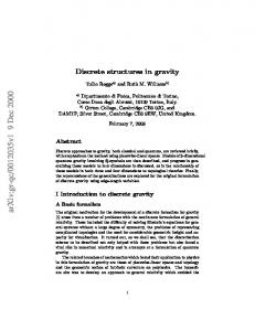
Our work consisted in a detailed gravimetric survey of Varge˜ao and Vista Alegre impact structures, located around 100 km apart from each other in a similar geological context. Therefore, we have divided this paper into two parts: Part I presents (this paper) the results obtained from gravity data acquired at Varge˜ao impact structure; Part II brings (in a separate paper) the results obtained for Vista Alegre impact structure. Interpretation of the results for both structures has provided valuable information that allowed to answer some important issues, such as: (i) even though the two structures are relatively close to each other, are they similar in terms of subsurface geology? Has one of the two impacts affected the subsurface more than the other? Are the volume and shape of possible uplifted sandstone strata similar? More specifically, Part I shows a selected 3D subsurface density model of the Varge˜ao impact structure constructed through gravity forward modeling. This model explains the observed gravimetric data within an acceptable error margin, and taking into account the available geological data. It depicts various geological characteristics such as the crater basement depth, the thickness of the rock layers and their shapes, the position of the central uplift and the location of some possible faults. Geological Setting The Paran´a Basin is a large intra cratonic sedimentary basin region located in South America, covering an area of approximately 1,700,000 km2 . It is composed of up to 6 km thick Cretaceous to Ordovician sedimentary and volcanic rocks (Zal´an et al., 1990). Milani et al. (1998) classified the stratigraphic record of the Paran´a Basin into six major super sequences, which comprise large temporal intervals in the geochronological time. They are: (1) Rio Iva´ı (Ordovician-Silurian); (2) Paran´a (Devonian); (3) Gondwana I (Carboniferous-Early Triassic); (4) Gondwana II (Meso-Late Triassic); (5) Gondwana III (Late Jurassic-Early Cretaceous); and (6) Bauru (Late Cretaceous). The impact structures of Varge˜ao and Vista Alegre are inserted in Super sequence Gondwana III (Serra Geral Formation; Fig. 1). Rocks of the Serra Geral Formation were originated during the early stages of rupture of the Gondwana supercontinent, during the transition from the Jurassic to the Cretaceous, which also marked the opening of the South Atlantic Ocean (Turner et al., Revista Brasileira de Geof´ısica, Vol. 33(2), 2015
i
i i
i
i
i “main” — 2016/6/15 — 14:09 — page 321 — #3
i
´ FERREIRA JC, LEITE EP, VASCONCELOS MAR & CROSTA AP
i
321
Figure 1 – Geological map of the Paran´a Basin. Varge˜ao and Vista Alegre impact structures are located in the states of Santa Catarina and Paran´a, respectively (Milani et al., 1998).
1994; Hawkesworth et al., 2000). This intense fissural volcanism of the paleocontinent resulted in a large area covered by lava flows (3/4 of the total basin area), with a thickness of up to 2000 meters (Milani et al., 2007). The fluvial-aeolian Piramb´oia Formation and aeolian sandstones that constitute the Botucatu Formation also belong to Super sequence Gondwana III. Precise positioning of the contact
between these two formations is difficult to determine because of high textural similarity (Fulfaro et al., 1980). Local Geology Both Varge˜ao and Vista Alegre impact structures were formed in volcanic rocks of the same stratigraphic unit, namely the Serra Geral Formation (Fig. 1), which makes them potentially similar
Brazilian Journal of Geophysics, Vol. 33(2), 2015
i
i i
i
i
i “main” — 2016/6/15 — 14:09 — page 322 — #4
i
322
i
˜ IMPACT STRUCTURE GRAVITY MODELING OF THE VARGEAO
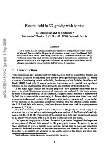
from a geological and geophysical point of view. Both have deformed sandstone outcrops in the central region, possibly belonging to the underlying Piramb´oia/Botucatu formations, and related to their respective central uplifts (Cr´osta et al., 2004; Vieira, 2009). The association of those outcrops with such stratigraphic units was made through the interpretation of surrounding well log data, located approximately 22 km away from the Varge˜ao structure where Piramb´oia/Botucatu sandstones occur below the basalts of the Serra Geral Formation, at depths between 980 to 1100 meters. Thus, the outcrops occur abnormally in these impact structures and they are also extremely deformed (Vieira, 2009), which is unusual for the otherwise undeformed strata. Vieira (2009) published a geological map of the Varge˜ao impact structure, which depicts the following main observed lithologies from bottom to top: deformed sandstones of the Piramb´oia/Botucatu formation, tholeiitic basalts of the Alto Uruguay unit; porphyry quartz-latite of the Chapec´o acid unit; and impact polymict breccias (Fig. 2).
Impact Structures An impact structure is created when an extraterrestrial projectile penetrates the Earth’s atmosphere with low deceleration, reaching the surface at high speeds (hypervelocity) and releasing a tremendous amount of energy concentrated in a relatively small area. The impact produces shock waves that affect the structure of the target rocks (French, 1998). Impact craters can be classified based on their morphologies into two main types: simple craters and complex craters. These distinct morphologies are characterized by their size and process of formation (French, 1998). Simple craters have diameters of about 2 to 4 km on Earth, and a basin or bowl shape (Fig. 3). Complex craters generally are larger than 2-3 km for sedimentary rock targets and exceed 4 km for igneous and metamorphic rock targets (Grieve, 2005). Their relatively higher central part is known as central uplift (Fig. 3) (French, 1998; Melosh, 1989). The formation of an impact crater can be divided into three basic and distinct steps: (a) contact and compression; (b) excavation; (c) modification. As shown in Figure 1, these stages apply to both simple and complex craters (Melosh, 1989). The first stage is when the projectile hits the target rock transferring a large amount of energy to it and generating what is called shock waves (Fig. 3a). In the second stage, shock waves propagate through the rock causing an excavation of the target ground, forming a transient crater structure (Fig. 3b). In the final stage, some modifications can occur, such as morphological changes, edge collapsing
and central uplifting, causing the transient to evolve into a more stable structure (Fig. 3c-d). This modification stage has no clearly marked end, merging gradually into regular geological processes such as erosion and sedimentation (French, 1998). The most prominent feature of an impact structure is its circular shape, but merely the existence of this morphological character is not sufficient to determine whether the structure has been generated by meteorite impact or not. To confirm an impact origin, permanent shock features recorded into the target rocks, such as shatter cones, planar fractures (PF) and planar deformation features (PDF), must be identified (French & Koeberl, 2010). A shatter cone is a macroscopic geological feature that is formed in the bedrock beneath an impact crater. Shatter cones are generated only if the target rock is submitted to a shock exerting pressures in the range of 2-30 GPa. Planar fractures (PF) are microscopic parallel fractures that are formed in minerals under pressures between 5 and 8 GPa. Planar deformation features (PDFs) are characterized by sets of parallel plane strains in mineral grains, occurring at pressures in the range of 8-30 GPa (French, 1998). There are 184 known impact structures on Earth (Earth Impact Database, 2014). Those structures are mainly concentrated in North America, Europe and Australia, with very few in South America. Brazil has six structures that have been proven to be of impact origin, namely: Araguainha, Varge˜ao, Serra da Cangalha, Vista Alegre, Riach˜ao and Santa Marta (Cr´osta & Vasconcelos, 2013). Some other structures in Brazil may also have been formed by meteoritic impact, but they are yet to be confirmed by geological evidence: Cerro do Jarau, Colˆonia, Praia Grande, Piratininga, S˜ao Miguel do Tapuio and Tef´e (Cr´osta, 2012).
The Varge˜ao impact structure The Varge˜ao circular structure was firstly identified in 1978 from analysis of Brazilian RADAR satellite images. It appears as an anomalous circular feature on a volcanic plateau in the western portion of Santa Catarina state (Paiva Filho et al., 1978). Based on its shape, as compared to the other known impact structures at the time, Cr´osta (1982) formulated the hypothesis of a meteorite impact to explain the formation of the Varge˜ao structure. However, a complete set of evidences of meteorite impact (shatter cones, PDFs, PFs and breccias) that proved the impact origin of Varge˜ao was published only in 2005 (Cr´osta et al., 2005). The Varge˜ao impact structure is located in the western portion of Santa Catarina state. It is centered on the geographical coordinates 26◦ 49’S and 52◦ 10’W (Fig. 1) and has an overall diameter of approximately 12.4 km (Fig. 2). It is a complex impact Revista Brasileira de Geof´ısica, Vol. 33(2), 2015
i
i i
i
i
i “main” — 2016/6/15 — 14:09 — page 323 — #5
i
´ FERREIRA JC, LEITE EP, VASCONCELOS MAR & CROSTA AP
i
323
Figure 2 – Geological map of the Varge˜ao area (Vieira, 2009).
structure with breccias and sandstones of Piramb´oia/Botucatu formations in its central uplift (Cr´osta et al., 2005). The sandstones within the structure have an anomalous stratigraphic position for this portion of the Paran´a Basin, where regular depths of these strata may reach more than 800 m. These outcrops are bounded by faults along the contact with the volcanic rocks of the Serra Geral Formation (Barbour Jr. & Corrˆea, 1981). The region was the subject of surveys related to hydrocarbon exploration and, therefore, there is a range of geophysical data available, such as: magnetic, data from an aerial survey Iguac¸ u River Project (PAULIPETRO); a seismic reflection line conducted by ANP – Agˆencia Nacional do Petr´oleo, G´as Natural e Biocombust´ıveis (National Agency of Petroleum, Natural Gas and Biofuels); remote sensing data such as SRTM digital elevation models and RADARSAT-1 and TERRA/ASTER. These data were used for a preliminary geophysical characterization of Varge˜ao (Kazzuo-Vieira et al., 2009). The application of regular chronos-
tratigraphic dating methods provided a maximum age of 125 Ma for basaltic rocks of the Serra Geral Formation (Turner et al., 1994). Recent zircon dating of breccias assigned an age of 123±1.4 Ma for the same rocks (N´ed´elec et al., 2013). METHODOLOGY All 419 ground gravimetric data were acquired in a field campaign in 2013 conducted with a CG-5 Scintrex gravity meter, along with a Trimble ProXT differential GPS for ellipsoid height measurements (see Li & G¨otze (2001) for a discussion about the use of ellipsoid versus geoid heights in gravity reductions). The gravity meter has a resolution of 1μGal. Accurate geometrical heights were obtained after applying differential corrections to the collected real time GPS positions at each data point location, using absolute positions from a nearby station. The final average height accuracy was ∼0.5 m. Accurate heights (