Li, Y., Faw, D. Jackson, J., and Dushman, D., 2002, âImaging of a Salt Face and Truncating Updip Sands using Offset VSP (OVSP) and a Salt Proximity Survey.
3D VSP Imaging and Visualization Yingping Li, Fran D. Doherty, and James C. Jackson, VSFusion, USA
Abstract 3D VSP images, surface seismic data, and well control data were visual interpreted using a 3D visualization tool specially designed for 3D VSP solutions. Data from three case studies were used to demostrate the power of the visualization tool in the enhancement and validation of the 3D images of subsurface structures, especially the reservior compartments. Introduction Three-dimesion Vertical Seismic Profiling (3D VSP) technologies have been uesed to improve reservior characterization. High resolution three-component (3C), 3D VSP data can be integrated with surface seismic and well logging data to provide detailed descriptions of formation properties and identification of reservior compartments. Cost effective simultaneous acqisition of both 3D surface and VSP data will result in tremandous voulumes of 3D VSP dataset. High resolution images of subsurface formation and reservior structures can be obtained using imaing methods such as 3D depth migration (Wang et al., 2004) and tomography (Li et al, 2003a). We recently developed a 3D visualization tool specifically for 3D VSP solutions. It is desigend to interpretively integrate multiple volume datasets (Figure 1) with a large number of different types of property parameters, such as 3D VSP and surface seismic volumes, grid and layer-based velocity models, log data, seismic attributes, geophysical/petrophysical property volumes, salt exit points, and faults. In this paper, we will demonstrate the power of our visaul interpration tool with real case studies.
Figure 1. 3D visualization of seismic volumes, complex geological structures, layer-velocity model, log curves in multiple wells.
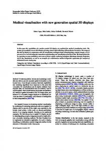
3D VSP Migration and Salt Proximity at Vinton Dome, Louisiana, UAS The geological province of Vinton Dome is onshore of Gulf of Mexico, South Louisiana Salt Basin. Over 1100 wells were drilled in field area and cumulative production exceeded 140 MMBO. 3D surface seismic and 3C-3D VSP data were simultanously acquired in 1998 by OPEX (Contance et al., 1999). 3C-3D VSP depth migration was carried out by Wang et al. (2004) using reflected P and SV waves. 3D depth migration image volume of reflections off the overhanged salt boundry and sediment layers are shown in Figure 2. The salt exit points (black dots) calculated using a salt proximity method are also displayed in Figure 2. Both the salt exit points and the salt reflection image are consistent. Both results from the seismic reflection and refraction methods validate exist of an overhanged salt boundary. 3D visualization with different degrees of transparent allow us to carefully examine the complex 3D structure of the salt-sediment boundary within the image volume. Multifarious VSP Survey at Gulf of Mexico Anadarko Tarantula #1 well drilled in the Gulf of Mexico, USA, in which an extensive VSP program was acquired (O’Brien et al., 2002). Data acquisition included one zero-offset VSP (ZVSP), two offset VSP (OVSP) surveys, a 3-D salt proximity (SP) survey, and a NorthSouth and a West-East walkaway VSP (WVSP), providing reasonably good dataset for comprehensive VSP analysis. Great Explorations – Canada and Beyond
1
O’Brien et al. (2002) derived salt-sediment boundary with the salt proximity survey and 2D Kirchhoff migration. The salt exit points are shown in Figure 3a. Li et al., (2003a) applied a traveltime tomography inversion method to the multifarious VSP dataset and obatined velocity distribution of the area (Figure 3b). The tomography image clearly delineates the salt-sediment boundary (Figure 3b). Analyzing of offset VSP wavefields, Wang et al. (2004) found significant reflected seismic energy off the inline source plane. Thus, a 3C-3D vector depth migration algorithm was developed to generate a 3D depth migration cube with the limited VSP dataset. The 3D migration image volume are shown in Figures 3a and 3b. We integrate the salt proximity, VSP tomography, and 3D VSP migration image together using our 3D VSP visaulization tool. The three results derived with different approaches can be easily load into visaulization system. 3D rotation, scan, and different degrees of transparence provide useful tools to visual interpretation these results. Our analysis indicates that three results are consistent each other. The tomographic solution and 3D VSP migration images provide a validation of the salt proximity result and yields an increased sense of confidence in the location of the steep salt flank.
Figure 2. 3D VSP migration volume showing images of the overhanged salt-sediment boundary and the updip sediments. Black dots are salt exit points derived using a salt proximity method. The vertical line indicates location of wellbore.
a)
b)
Figure 3. a) Survey geometry with vertical well and seismic sources of the offset VSP (red dots), salt proximity(Black dot),and walkaway VSP (blue dots). 3D salt exit points are superimposed on 3D images of depth migration cube. b) Visual Integration of 3D depth migration volume, salt exit points, and velocity distribution from traveltime tomography.
VSP vs. Surface Seismic Data in Gulf of Mexico Our last example is at Eugene Island area, also in the Gulf of Mexico, USA. Comprehensive borehole seismic surveys were designed and acquired in order to obtain a better image of the updip sands and the salt flank. Both VSP and salt proximity surveys were carried out to image updip sands and salt-sediment boundary (Li et al., 2002, 2003b). Figure 4a shows the survey geometry with offsset VSP, salt proximity and zero-offset velocity survey. Offset VSP was used to image both updip sediment reflections (Figure 4b) and reflections off the salt-sediment boundary (Figure 4c). Figure 4d shows that the tip of the salt overhang was very close to the instrumented well (pink) and a small portion of the overhang was penetrated by the original well (orange). The well control data Great Explorations – Canada and Beyond
2
provide good calibration points. It is observed that the high amplitude reflectors (red), determined by OVSP depth migration imaging, terminate at the salt face defined by the salt exit points (Figure 4d). Salt exit points derived from salt proximity survey are superimposed on surface seismic section in Figures 4e and 4f. This example demonstrate that the OVSP images, salt exit points, well control data, and surface seismic data can be integrated to provide an accurate picture of the salt geometry, the magnitude of any salt overhang, and the extent of reservoir sands. Our 3D visualization package provides useful tools to integrate all data avialable for best characterizing reservior structures.
VS
OVSP
3DSP
a)
b)
c)
d) e) f) Figure 4. a) Source locations of Offset VSP, Salt Proximit, and Velocity Survey and multiple well paths as well as salt exit points (black dots). b) Salt exit points superimposed on updip sand images. c) Depth migration image of salt-sediment boundary vs. salt exit points. d) salt exit points, sediment image and well paths are displayed from the front and back. e) Front and f) back display of surface seismic section, salt exit points, and well paths.
Conclusions It is shown that a 3D visualization tool for 3D VSP solutions is powerful to integrate 3D VSP images, 3D salt exit points, surface seismic, well control and log data. 3D visual intepration of 3D VSP and other data will lead a better reservior characterization with higher resolution. Comprehensive analysis of results from different methods will lead a better characterization of the salt flank with a high degree of confidence in a complex geological setting. This study also shows that the visual tools in the system can handle multiple datasets in a simple and robust manner. 3D VSP processing and interpretation results can be delivered as digital multimedia products. Acknowledgement Authors would like to thank Anadarko, OPEX for release VSP data. Thanks also to J. O’Brien, P. Constance, D. Wang, J. Zhang, J. Yang for help discussion and encoragement. Great Explorations – Canada and Beyond
3
References Li, Y., Faw, D. Jackson, J., and Dushman, D., 2002, “Imaging of a Salt Face and Truncating Updip Sands using Offset VSP (OVSP) and a Salt Proximity Survey (SPS) in the Gulf of Mexico”: Extended Abstracts 72nd SEG International Meeting, Salt Lake City, UT, In CD-ROM. Li, Y., O’Brien, J., Mallick, B., Zhang, J., Wang, D., Barberan, C., Dushman D., 2003a, Tomographic velocity determination of the sedimentary and salt flank images using multifarious VSP data, 8th Internat. Congress of Brazilian Gephys. Soc. in CD-ROM. Li, Y., Faw, D., Jackson, J., Dushman, D., and F. Doherty, F., 2003b, Multifarious VSP methods for imaging of complex structures with three-component data, First Break, 21, 43-48. O’Brien, J., Mallick, B., Lakings, J., and Barberan, C., 2002, Locating the Salt Flank using Borehole Seismic Techniques: Extended Abstracts 72nd SEG International Meeting, Salt Lake City, UT, In CD-ROM. Wang, D., Li, Y., O’Brien, J., and Mallick, B., 2004, Vector 3C3D Depth Migration of Salt Images Using Limited VSP Data, AAPG Extended Abstracts, Dallas, Accepted.
Great Explorations – Canada and Beyond
4