A Coastal Ocean Observing System and Modeling Program for the West Florida Shelf Robert Weisberg Ruoying He Mark Luther John Walsh
Rick Cole Jeff Donovan Cliff Merz Vembu Subramanian College of Marine Science University of South Florida 140 7th Ave. S. St. Petersburg, FL 33701
[email protected]
Abstract-The Coastal Ocean Monitoring and Prediction System (COMPS) is a real-time, web-based (http://comps.marine.usf.edu) coastal ocean observing and modeling system for the west coast of Florida. COMPS observations consist of coastal and offshore stations, each with in-situ ocean and air-sea interaction measurements. Some of these stations are maintained by the University of South Florida and others are maintained by various local, state and federal agencies. Our web-site imports and serves all available real-time data. The COMPS array also provides a backbone for process experimentation, inclusive of other non-realtime data sets, and it is supported by a numerical circulation modeling program for process experiment hindcasts and for nowcasts and forecasts. Through this coordinated program of in-situ measurements and models we are making headway in understanding material property distributions on the West Florida Shelf and how these impact shelf ecology. The COMPS in situ data and modeling program and some of its principal scientific findings are discussed. Based on these we provide recommendations on a basic set of measurements for future integrated sustained coastal ocean observing systems. I. INTRODUCTION The West Florida Shelf (WFS) is an excellent natural laboratory for studying continental shelf processes. It contains both topographic end members: regions of wide, gently sloping and narrow, steeply sloping isobaths; it has an adjacent boundary current, the Gulf of Mexico Loop Current; and it is meteorologically forced by well defined seasons of positive and negative heat flux, major river inflows, and modulated synoptic scale winds. These combined influences of regional geometry, local forcing by rivers, winds, and heat flux, and deep-ocean forcing by the Loop Current yield a diversified range of ecological phenomena such as harmful blooms of K. brevis red-tide contrasted with productive commercial and recreational fisheries. Florida's west coast also supports a major tourist industry. All of these factors demand that we understand
0-7803-7535-1/$10.00©2002 IEEE
530
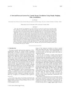
the multidisciplinary workings of the WFS in order to better manage its resources. Weather on the Florida peninsula is also punctuated by tropical cyclones in summer/fall and extratropical storms in winter/spring, and storm surge in either case can be substantial. Out of the needs for better advisories on coastal flooding and improved understanding of shelf ecology was born the Coastal Ocean Monitoring and Prediction System (COMPS) for the west coast of Florida. COMPS is operated by the College of Marine Science, University of South Florida. It combines real time data acquisition from coastal and offshore stations with numerical circulation modeling to assist emergency managers and research scientists. COMPS operates its own measurement sites while also importing data from other state, local, or federal agency operated sites. All available real time data are served to the public at http://comps.marine.usf.edu along with links to satellite remotely sensed products and numerical model results. Collaborating agencies include the Florida Department of Environmental Protection, Florida Marine Research Institute, Florida Division of Emergency Management, Florida Institute of Oceanography, Citrus County, Pasco County, City of Tarpon Springs, Southwest Florida Water Management District, South Florida Ocean Measurement Center, United States Geological Survey, National Oceanic and Atmospheric Administration, Office of Naval Research, United States Coast Guard, and Minerals Management Service. Section II describes the COMPS program and its interactions with other research programs on the west coast of Florida. Section III discusses some of our research findings. Based on these findings section IV provides suggestions for future monitoring of the WFS and elsewhere. II. THE COMPS PROGRAM AND INTERACTIONS The COMPS measurement domain, presently extending from Dania Florida in the southeast to Pensacola Florida in the northwest, consists of some 48 stations, 23 of which (including nine in Tampa Bay) are operated by USF,
Fig. 2. The COMPS buoy deployed on the 25 m isobath offshore of Sarasota Florida Fig. 1. The COMPS web-page at http://comps.marine.usf.edu or by USF in partnership with other agencies. A detailed station listing is provided at the web-site. Visitors to the web-site are greeted with the station map shown in Fig. 1. Clicking on any of the sites brings up the available data, which vary from site to site. Coastal stations nominally provide sea level and surface meteorology; offshore stations nominally provide surface meteorology; and the instrument suites and telemetry vary with location. The most completely instrumented sites are those within Tampa Bay as part of the Tampa Bay PORTS system (jointly operated by USF and NOS) and buoys located offshore. We presently maintain four offshore installations, two with complete air-sea interaction sensors (wind speed and direction, air and sea surface temperature, barometric pressure, relative humidity, rainfall, and incoming short and long wave radiation), water column currents, and water column temperature and salinity (T/S), all telemetered in near real time (with an approximate 1 hour delay) by GOES satellite, and two with a lesser array of surface meteorology (no radiation sensors) and without telemetry for currents or T/S. Fig. 2 depicts our mooring situated on the 25 m isobath offshore of Sarasota Florida. Plans are presently in place through NOAA MERHAB and ONR SEACOOS to: 1) add two more telemetering offshore locations, one on the 40 m isobath offshore of Sarasota and another on the 25 m isobath northeast of the Dry Tortugas and 2) add telemetry for currents and T/S to the two existing moorings located on the 50 m isobath offshore of Tampa Bay and Charlotte Harbor. SEACOOS will also provide a high frequency radar for mapping surface current and wave fields. When accomplished within the next year, COMPS and its associated programs will have substantial coverage for winds, waves, and currents over a major portion of the WFS. To this we will also have
a number of profiling floats that will telemeter water column T/S for objectively mapping fields. A portion of the anticipated USF moored array is shown in Fig. 3.
Fig 3. Buoys (triangles) with real time telemetry for currents and T/S anticipated for 2003. The two circles have radii of 100 km and 200 km from the center drawn at the mouth of Tampa Bay Depending upon the range and location of the specific radar chosen (to be determined this year through comparative field trials) we will have several sites for quantitative comparisons between currents measured either in-situ over the water column or remotely at the surface. The numerical modeling portion of COMPS presently uses the primitive equation Princeton Ocean Model [1]. The model domain extends from the Florida Keys to the
531
Mississippi River with one open boundary arching between (Fig. 4) where a radiation boundary condition is applied. Horizontal resolution varies from about 2 km near-shore to about 6 km at the open boundary, and 21 sigma layers are used in the vertical. Several preliminary studies, including barotropic responses to either climatological monthly mean winds or to upwelling and downwelling favorable winds [2, 3, 4] and baroclinic responses to either a specific upwelling case study or a series of wind-forced upwellings and downwellings [5, 6], were completed before engaging in more realistic hindcast and nowcast/forecast simulations. We also considered storm surge responses to prototypical categories 2 and 4 hurricanes [7].
Fig. 4. The COMPS regional model domain. Both the observational and modeling activities of COMPS have evolved in concert with other funded research programs. COMPS, in essence, has provided a backbone on which to expand process experimentation. Mutually supportive have been cooperative agreements between the USGS Center for Coastal Geology and USF, followed by one with the MMS. We then engaged in a NOAA sponsored ECOHAB regional field study coincident with the ONR sponsored HyCODE program on multidisciplinary factors that affect ocean color.
first attempt at hindcast simulation [8] was for the spring season transition of 1999, a time when Loop Current interactions with the shelf were not important. The model T/S stratification was initialized to be uniform over the entire domain using climatology below and hydrographic cruise data above 200 m. Beginning from this initial stratified state of zero baroclinicity, the model rapidly developed baroclinicity in balance with the local forcing. Quantitative agreements were achieved between the model simulation and the in-situ data thereby allowing us to diagnose the spring transition behavior and to account for regularly observed WFS features such as the spring "green river" [9] independent of the Loop Current. Direct effects by the Loop Current are anticipated to be small based on shelf width [10], and model experiments compared against data for a specific Loop Current impact event at the shelf break offshore of Tampa Bay demonstrate that this is true for the WFS, unpublished [11]. However, under special circumstances, when the Loop Current impacts relatively shallow isobaths at their convergence west of the Dry Tortugas, the Loop Current can have a major affect on the shelf circulation [12]. A southwest corner impact did occur during spring-fall 1998 when the shelf was anomalously cold and stratified and nutrient levels were elevated. These anomalous behaviors are accounted for, unpublished [13], on the basis of both local and deep-ocean forcing contributions. Deep-ocean forcing did two things. It elevated the height of material surfaces at the shelf-break, and it set the shelf currents in motion. Local wind and heat flux forcing was still required however for these elevated material surfaces to broach the shelf-break. From the bottom temperatures either observed or modeled on the shelf, do to upwelling across the shelfbreak, the elevated nutrient levels are accounted for by either historical or contemporaneously observed temperature/nutrient relationships. Once on the shelf a combination of local and deep-ocean forcing was responsible for distributing these cold, nutrient rich waters across the shelf and into the near-shore region. The primary conduit for across-shelf transport was the bottom Ekman
III. RECENT RESEARCH FINDINGS Our research approach has generally been to combine in-situ measurements with numerical model experiments, recognizing that measurements will always be sparse, and models will always be limited by initializations, boundary conditions, and model physics. The observational findings have served as motivation for experiments and as a means for quantitative comparison. Given a regional model our initial focus has been on the effects of local forcing independent of the Loop Current. For hindcasts, under local forcing only, we have used NCEP reanalysis winds and surface heat fluxes (with a sea surface temperature based flux correction) and inflows from seven major rivers. Our
Fig. 5. Modeled near bottom flow field on May 15, 1998.
532
layer induced by southward currents do to both the local winds and the remote Loop Current impact near the Dry Tortugas. An example of the near bottom flow as modeled in mid-May 1998 is shown in Fig. 5. Simulated Lagrangian trajectories, originating near the bottom at the shelf-break and integrated over the spring-fall seasons, demonstrate that water properties observed near-shore between Tampa Bay and Charlotte Harbor came from farther north in the Florida Big Bend and Panhandle. An example for a threemonth-long summer 1998 integration is shown in Fig. 6.
and an example of the web-based product for storm surge induced sea level is shown in Fig. 7 for tropical storm Barry. A separate nowcast/forecast system is also available for Tampa Bay, and, since density there is determined primarily by salinity and sufficient river data are available, this model is fully baroclinic.
Fig. 7. Sea level nowcast from August 3, 2001 for tropical storm Barry. IV. OBSERVING SYSTEM IMPLICATIONS
Fig. 6. Summer 1998 Lagrangian path lines for neutrally buoyant particles originating at the 50 m, and 100 m isobaths. Using the modeled circulation fields and the nutrient distributions, unpublished [14] accounts for the observed phytoplankton species behavior en route under varying light conditions, which is our first attempt at a coupled physical-biological model simulation under three– dimensional, baroclinic conditions. Along with hindcast simulations we also implemented a web-based nowcast/forecast model which is presently limited to a barotropic wind driven system. The model has constant density and is driven by NCEP Eta model winds with nowcasts and 36 hour forecasts, updated daily. Converting this to a baroclinic model is simple in principle, but it requires adequate surface heat flux and contemporaneous river inflow products, along with data assimilation, to maintain the density field. Sea level is the least affected prognostic variable by these limiting factors,
Our COMPS experience bears upon future monitoring of continental shelves. The bottom Ekman layer, being a conduit for across-shelf transport requires measurements of circulation and water properties. Measurements are also required at the shelf break because deep-ocean properties must first broach the shelf-break if they are to be advected across the shelf. For the WFS the depth of the shelf-break (defined here as the initial change in slope between the shelf and the deep-ocean) varies with location, making some regions preferred sites for deep-water penetration onto the shelf. Nutrients also enter the near-shore zone via rivers and estuaries and it is common to observe phytoplankton blooms within near-shore, salinity gradient regions. The circulation dynamics in such regions are also different do to the added stratification. Thus, near-shore measurements are also needed. The baroclinic structure of the shelf may also change in the across-shelf direction do to the combined effects of surface heat flux and shelf-break upwelling. A moored array that emphasizes the shelf-break, the mid-shelf, and the near-shore is therefore necessary with full water column multidisciplinary data along with surface meteorology for improved marine weather prediction. Moorings alone are not sufficient, however. Models require fields of variables for initialization and data assimilation. The T/S fields are particularly important because stratification determines the turbulence structure of the water column and hence the coastal ocean response to external forcing. T/S fields can be mapped using profiling floats, gliders, and other autonomous vehicles. Surface fields of currents, waves, and winds by high frequency radar are also of great value. Emergency managers need
533
coastal sea level at strategic locations for monitoring coastal flooding. When combined these monitoring requirements, for satisfying multidisciplinary scientific and pragmatic civil service needs, make maintaining an integrated, sustained coastal ocean observing system a daunting task. Nevertheless, judicious allocation of resources at key regions of importance will greatly improve the utility of such observing systems and facilitate the ultimate role of models in extrapolating limited observations over a much broader domain. Acknowledgments
Florida shelf," Geophys. Res. Lett., vol 26, pp22392242, 1999. [13] R.H. Weisberg and R. He, "Local and deep-ocean forcing contributions to anomalous water properties on the west Florida shelf," Jour. Geophys. Res., submitted. [14] J.J. Walsh, R.H. Weisberg, D.A. Dieterle, R. He, B.P. Darrow, J.K. Jolliff, G.A. Vargo, G. Kirkpatrick, K. Fanning, T.T. Sutton, A. Jochens, D.C. Biggs, B. Nababan, C. Hu, and F. Muller-Karger, "The phytoplankton response to intrusion of slope water on the west Florida shelf: models and observations," Jour. Geophys. Res., submitted.
The sea-going assistance provided by the officers and crew of the R/V Suncoaster operated by the Florida Institute of Oceanography is greatly appreciated. REFERENCES [1] A.F. Blumberg and G.L. Mellor, "A description of a three-dimensional coastal ocean circulation model," in N. Heaps, Ed., Three-dimensional coastal ocean models, vol. 4, AGU, Washington, DC, 1987, pp208233. [2] H. Yang and R.H. Weisberg, "Response of the west Florida continental shelf to climatological monthly mean wind forcing," Jour. Geophys. Res. vol. 104, pp 5301-5320, 1999. [3] Z. Li and R.H. Weisberg, "West Florida continental shelf response to upwelling favorable wind forcing, part I: kinematical description," Jour. Geophys. Res. vol. 104, pp 13507-13527, 1999. [4] Z. Li and R.H. Weisberg, "West Florida continental shelf response to upwelling favorable wind forcing, part II: dynamical analyses," Jour. Geophys. Res. vol. 104, pp 23427-23442, 1999. [5] R.H. Weisberg, B.D. Black, and Z. Li, "An upwelling cae study on Florida's west coast," Jour. Geophys. Res. vol. 105, pp 11459-11469, 2000. [6] R.H. Weisberg, Z. Li, and F. Muller-Karger, "West Florida shelf response to local wind forcing," Jour. Geophys. Res. vol. 106, pp 31239-31262, 2001. [7] H. Yang and R.H. Weisberg, "A three-dimensional numerical study of storm surges along the west Florida coast," College of Marine Science, University of South Florida, St. Petersburg FL, COMPS Technical Report, December 2000, 54pp. [8] R. He and R.H. Weisberg, "West Florida shelf circulation and temperature budget for the 1999 spring transition," Cont. shelf Res., vol 22, pp719-748, 2002. [9] F. Gilbes, C. Tomas, J.J. Walsh, F.E. Muller-Karger, "An episodic chlorophyll plume on the west Florida shelf," Cont. Shelf Res., vol 16, pp1201-1224, 1996. [10] D.C. Chapman and K.R. Brink, "Shelf and slope circulation induced by fluctuating offshore forcing," Jour. Geophys. Res. vol. 92, pp 11741-11759, 1987. [11] R. He and R.H. Weisberg, "A loop current intrusion case study on the west Florida shelf," J. Phys. Oceanogr., submitted. [12] R.D. Hetland, Y. Hsueh, R.R. Leben, and P.P. Niiler, "A loop current induced juet along the edge of the west
534