Within the service architecture a flexible Location Enabling Server (LES) .... VPS. Virtual Positioning System. WGS. World Geodetic System. WAAS ...... heterogeneous dedicated and location-inferring positioning systems relying on the.
Technische Universität München Lehrstuhl für Kommunikationsnetze
A Distributed Community-Based Location Service Architecture Maximilian Zündt
Vollständiger Abdruck der von der Fakultät für Elektrotechnik und Informationstechnik der Technischen Universität München zur Erlangung des akademischen Grades eines Doktor-Ingenieurs genehmigten Dissertation.
Vorsitzender: Prüfer der Dissertation:
Univ.-Prof. Dr. sc. nat. Christoph-Georg Günther 1. Univ.-Prof. Dr.-Ing. Jörg Eberspächer 2. Univ.-Prof. Bernd Brügge, Ph.D.
Die Dissertation wurde am 24.05.2007 bei der Technischen Universität München eingereicht und durch die Fakultät für Elektrotechnik und Informationstechnik am 21.11.2007 angenommen.
ii
Foreword This work has been developed while being a research assistant at the Institute of Communication Networks (LKN) and Center for Digital Technology and Management (CDTM) at the Technische Universität München. During my time at these institutes, I was not only able to gain deep understanding of the field of location technologies and services but also a broad interdisciplinary knowledge by conducting various research projects, carrying out courses and performing organizational tasks at the CDTM. Without the support of many individuals this work would have never been completed. It has been a great pleasure to work with all my former CDTM colleagues and staff members of the LKN. Being part of the first generation of CDTM assistants, I learnt that a small group of highly motivated people can achieve great things when working together, even with little resources available. Many special thanks go out to Peter Dornbusch, Martin Huber, Jonathan Landgrebe and Matthias Möller. The uncomplaining support of Mrs. Uta Weber, her skills to smoothly handle all challenges and specialties of CDTM administration were always an invaluable resource. She contributed a lot to my work by providing me creative and friendly support in many times. Many thanks go to my doctorial studies supervisor Prof. Dr. Jörg Eberspächer who always engaged me in fruitful discussions and guided me successfully towards my research goals. I would also like to express many thanks to Prof. Bernd Brügge of the Chair for Applied Software Engineering for being my second examiner. Apart from all the regular staff members, many students have provided extremely valuable work to the success of this thesis. Among them are Peter Ippy, Hermann Anton Karl, Bernd Laqua and Manuel Puerta. My family and friends have always backed me up throughout the ups and downs of research. I thank you all. Last but not least, I would like to thank my parents Heidelinde and Siegfried Zündt for supporting me heartily at all times with their wisdom and generosity. To them I owe everything.
Munich, March 2007
Maximilian Zündt
iii
Abstract Location-based services (LBS) to date offer information and specific services tailored to the current geographic usage environment. The “location service” delivering the required location information in turn is provided by a location platform using specific positioning technologies and geodetic data (e.g. maps). Currently no single positioning technology or location platform can provide a location service as well as geodetic data for all known LBS usage environments and required location QoS (i.e. accuracy, delay, etc.). Hence scientific research agrees that a truly ubiquitous location service can only be obtained by use of heterogeneous positioning technologies in our daily living environment, that is, by use of dedicated systems such as GPS and technologies capable of also being used for positioning e.g. the abundance of heterogeneous networks all around us. The difficulty which remains is how to effectively “capture” this diversified technology data, generating meaningful location information and providing a homogeneous ubiquitous location service. In this thesis we present a novel distributed location service architecture which focuses on the collaborative generation and centralized provisioning of location information derived from heterogeneous networks and readily available positioning systems using distributed heterogeneous location platforms. The architecture is specified using an abstract system model. It contains functional components structured by three major core processes representing its initialization, positioning, and self-optimization properties. Client-based sensor mechanisms paired with centralized knowledge databases and community user models have been combined to provide a self-optimizing and domain independent location service framework. Within the service architecture a flexible Location Enabling Server (LES) framework has been developed, representing the initialization and sustainability processes of a LES for various dynamic usage environments. The initialization of a community-based LES with focus on collaborative, community-based network environment data acquisition for positioning purposes has been analyzed and successfully simulated for an outdoor innercity usage scenario. On the data processing side, suitable initialization and positioning models have been evaluated and empirically tested using captured WLAN hotspot information, showing the localization performance in relation to GPS within inner-cities. An important requirement for providing a ubiquitous location service is the discovery of distributed location platform entities with different geographic scopes of responsibility. Using the heterogeneous network and/or GPS sensor information discovered by the mobile client, we have developed a network independent, DHT-based peer-to-peer location platform lookup mechanism using XPath in a hierarchical Chord ring structure. A demonstrator has been implemented showing the effectiveness of this approach. Finally, a working location service architecture prototype has been implemented. As a proof of concept, a seamless indoor/outdoor navigation application has been implemented using two fully functional location platform entities.
iv
Kurzfassung Ortsbezogene Dienste stellen Informationen und Dienste passend zu der jeweiligen Lokalität eines Benutzers oder Gegenstandes zur Verfügung. Der Dienst, welcher die dazu nötigen Ortsinformationen bereitstellt, verwendet geeignete Lokalisierungssysteme und Geo-Informations-Datenbanken über eine „Location Plattform“. Jedoch sind die gegenwärtig verfügbaren Lokalisierungslösungen nicht in der Lage, allgegenwärtig und für jeden Lebensraum brauchbare (d.h. Innen- wie Außenbereich) und dem ortsbezogenen Dienst anforderungsgerechte Ortsinformationen zu liefern. Durch die effiziente Nutzung von verteilten, heterogenen Lokalisierungslösungen und Bereitstellung von Ortsinformationen über standardisierte Schnittstellen ist das Ziel der Forschung die Entwicklung von adaptiven, allgegenwärtigen ortsbezogenen Diensten in verschiedenen Umgebungen. Hierzu werden unterschiedlichste dedizierte und kommunikationsnetze–abhängige Lokalisierungslösungen verwendet. Die Schwierigkeit besteht darin, die dadurch vorhandene Heterogenität der Technologien und Lokalisierungsverfahren effizient und kostengünstig im Griff zu bekommen, um einheitlich Ortinformationen zu generieren und bereitzustellen. Diese Arbeit beschreibt eine neuartige Dienstarchitektur für die Bereitstellung von verteilten Ortsinformationsdiensten. Der Schwerpunkt liegt auf kollaborativer Generierung und zentralisierter Bereitstellung von Ortsinformationen, welche aus heterogenen Netzen und mit herkömmlichen Lokalisierungsverfahren (z.B. GPS) gewonnen und verfügbar gemacht werden können. Die Beschreibung und Modellierung der Dienstarchitektur erfolgt aus verschiednen Sichtweisen. Sie umfasst die Struktur und das Verhalten von Steuerkomponenten für die Bereitstellung eines homogenen Ortsinformationsdienstes, sowie die dazu gehörenden Prozesse für die Initialisierung, Lokalisierung und Selbstoptimierung. Hierzu wurden endgeräte-basierte Sensormechanismen, zentralisierte Wissensdatenbanken und community-basierte Operations- und Verhaltensmodelle zu einem durchgängigen Servicekonzept vereinigt. Die Bereitstellung des homogenen Ortsinformationsdienstes wurde durch eine getrennte Teilnehmer-, Ortsinformationsdienst- und ortsbezogene Dienststeuerung über die dafür verantwortliche Dienstbereitstellungseinheit realisiert. Für die Initialisierung, Lokalisierung und Selbstoptimierung eines verteilten Ortsinformationsdienstes wurde ein universelles „Location Enabling Server“ (LES). Rahmenwerk entwickelt, welches die zugehörigen Prozesse in den jeweiligen Lebensräumen über die zentrale Dienstbereitstellungsentität unterstützt. Das Rahmenwerk und die Prozesse wurden erfolgreich anhand einer community-basierten LES-Simulation und -Implementierung untersucht. Eine weitere wichtige Anforderung in der Bereitstellung eines allgegenwärtigen Ortsinformationsdienstes unter der Verwendung von verteilten heterogenen Dienstquellen ist die Auffindung des geeigneten Dienstes in dem aktuellen Lebensraum. Hierzu wurde ein DHT-basierter Peer-to-Peer-Service-Discovery-Mechanismus entwickelt, der eine netzunabhängige Dienstauffindung anhand von endgerätegenerierten Sensorinformationen ermöglicht. Die Funktionalität des gewählten Ansatzes
v
wurde erfolgreich in einem Prototypen bewiesen. Wesentliche Teile der Dienstarchitektur wurden prototypisch realisiert. Darauf aufbauend wurde zusätzlich ein Navigationsdienst prototypisch umgesetzt, welcher eine durchgängige Navigation zwischen Innen- und Außenbereichen unter der Verwendung vorhandener Lokalisierungssystemen ermöglicht.
vi
Abbreviations 2dRMS AAA ACL AGPS AOA AP API BT CSCF CEP CDTM COO CORBA CoBrA CORBA CSD DCOM DECT DGPS DHCP DNS DHT EGPS EMI EOTD ERN ESSID EGNOS FM GMLC GTB GIS GPRS GNSS GPS GSM GLONASS HLR HSS HTTP IM IMS IP JNI
Two-dimensional Root Mean Sqaure Authentication, Authorisation and Accounting Access Control List Assisted GPS Angle of Arrival Access Point Application Programming Interface Bluetooth Call Session Control Function Circular Error Probability Center for Digital Technology and Management Cell of Origin Common Object Request Broker Architecture Context Broker Architecture Common Object Request Broker Architecture Circuit Switched Data Distributed Component Object Model Digital Enhanced Cordless Telecommunications Differential-GPS Dynamic Host Configuration Protocol Domain Name Service Distributed Hash Table Enhanced-GPS Electro Magnetic Interference Enhanced Observed Time Difference External Resource Network Enhanced Service Set Identifier European Geostationary Navigation Overlay Service Frequency Modulated Gateway Mobile Location Centre Geo Tool Box Geographic-Information System General Packet Radio Service Global Navigation Satellite System Global Positioning System Global System for Telecommunications Globalnaya Navigationnaya Sputnikovaya Sistema Home Location Register Home Subscriber Subsystem Hypertext Transfer Protocol Initialization Module IP Multimedia Subsystem Internet Protocol (RFC 791) Java Native Interface
vii
LPR LACBA LASAP LAM LBS LC LCD LCM LCP LCS LDAP LDB LES LiF LIN LMU LKN LLA LLD LLM LLP LOS LP LPA LPP LPM LRD LS LSM LSP LT MAC MEA MLP MM MPP MSC MSC MR MTSAT NMEA OMA OOD OSDE OSGi P2P PAU PDA PDB PM PPS
Local Positioning Radar Location-Aware Community-Based Architecture Location-Aware Service and Application Platform LACBA Access Manager Location-Based Service LACBA Client LACBA Client Database LACBA Client Manager LACBA Client Proxy Location Core Server Lightweight Directory Access Protocol Location Platform database Location Enabling Server Location Interoperability Forum Location Identification Number Location Measurement Unit Lehrstuhl für Kommunikationsnetze Latitude, Longitude, Altitude LES Location Service Database LES Location Service Manager LES Location Service Proxy Line of sight Location Platform Location Platform Agent Location Platform Proxy Location Platform Manager Location Reference Database Location Service Location Service Manager Location Service Proxy Location Trader Media Access Control Means Ends Analysis Mobile Location Protocol, by OMA Module Manager Mobile Positioning Protocol, by Ericcson Mobile Switching Center Mobile Switching Center Module Repository Multifunctional Transport Satellite System National Marine Electronics Association Open Mobile Alliance Object-Oriented Design Open Services Delivery Environment Open Services Gateway Initiative Peer to Peer Profile Authentication Unit Personal Digital Assistant Policy Database Positioning Module Precise Positioning Service
viii
P-CSCF QoS RDS RFID RNC RSS RPA SA SB SDB SMLC SIP SLP SOA S-CSCF SGSN SRNC SOAP SSID SPS TDOA TMC TOA TUM UDDI UMTS UTRAN UDB UP UTDOA UTM UWB VoIP VPS WGS WAAS WGS84 WLAN WSDL XML
Proxy CSCF Quality of Service Radio Data System Radio Frequency Identification Radio Network Controller Received Signal Strength Redundant Positioning Architecture Selective Availability Shared Buffer Service database Serving Mobile Location Centre Session Initiation Protocol Service Location Protocol Service-oriented Architecture Serving CSCF Serving GPRS Support Node Serving RNC Simple Object Access Protocol Service Set Identifier Standard Positioning Service Time Difference of Arrival Traffic Message Channel Time of Arrival Technische Universität München Universal Description, Discovery and Integration Universal Mobile Telecommunications System UMTS Terrestrial Radio Access Network User database User Proxy Upload TDOA Universal Transverse Mercator Ultra Wideband Voice over IP Virtual Positioning System World Geodetic System Wide Area Augmentation System World Geodetic System 1984 Wireless Local Area Network Web Services Description Language Extensible Markup Language
ix
Contents Chapter 1 Introduction .......................................................................................................................... 1 1.1.
Motivation ............................................................................................................................1
1.2.
Goal, Approach and Architecture Features...........................................................................3
1.3.
Related Research Areas ........................................................................................................6
1.4.
Contribution of this Work.....................................................................................................7
1.5.
Structure of this Thesis .........................................................................................................8
Chapter 2 Fundamentals and new Perspectives on Location Service Provisioning ....................... 11 2.1.
Location-Awareness and Location-Based Services............................................................11
2.2.
Positioning Systems and Technologies...............................................................................14
2.2.1 2.2.2 2.2.3 2.2.4 2.2.5 2.2.6 2.2.7 2.3. 2.3.1 2.3.2 2.3.3 2.3.4 2.4. 2.4.1 2.4.2 2.4.3 2.4.4 2.4.5 2.5.
Location Models and Location Data Characteristics .....................................................14 Principles of Localization ..............................................................................................17 Description and Classification of Positioning Systems..................................................19 Dedicated Positioning Systems......................................................................................22 Communication Network Dependent Positioning Systems ...........................................23 Identity-Based Positioning Systems...............................................................................25 Summary Discussion .....................................................................................................26 Location Service Provisioning............................................................................................27 The Location Platform Principle....................................................................................27 Evaluation Criteria of the Location Platform Concepts .................................................28 Current Location Platform Approaches .........................................................................29 Summary Discussion .....................................................................................................33 Location Information Generation and Provisioning by User Communities .......................33 Description of a Community..........................................................................................33 Growth and Development of a Community ...................................................................35 User Integration and Roles within the Community........................................................37 Communities Using and Generating Location Information ...........................................39 Summary........................................................................................................................41 Features of a Global Location Service Architecture Supporting Community Principles ...41
Chapter 3 Overview and Evaluation of Existing Location Service Architecture Concepts........... 44 3.1. 3.1.1 3.1.2 3.2. 3.2.1 3.3. 3.3.1 3.4.
Context-Aware Architecture Frameworks focusing on Location .......................................45 The Redundant Positioning Architecture (RPA)............................................................45 The Location Stack ........................................................................................................47 Service-oriented Architectures ...........................................................................................47 The Service Architectures LASAP and Symphonia ......................................................48 Mobile Operator-based and Open Standards ......................................................................49 Polos ..............................................................................................................................50 Distributed, Middleware-based and Device-centric Location Service Platforms ...............50
x 3.4.1 3.4.2 3.4.3 3.5. 3.5.1 3.5.2 3.6.
The Device-Centric Location Platform TraX ................................................................50 Nimbus: A Distributed Middleware-based Location Platform ......................................51 A Middleware-Based Approach on Efficient Location Service Signalling ...................52 Community–based Location Platforms ..............................................................................53 Generation of Location-based Content by PILGRIM ....................................................53 Operator-Independent Location Service Provisioning...................................................54 Summary Discussion and Conclusion ................................................................................54
Chapter 4 Modeling a New Location Service Architecture .............................................................. 58 4.1. 4.1.1 4.1.2 4.1.3 4.1.4 4.2. 4.2.1 4.2.2 4.2.3 4.2.4 4.2.5
Basic Concepts of LACBA.................................................................................................59 The LACBA Use Case Model .......................................................................................60 The LACBA Location Service.......................................................................................61 Generating and Adapting Location Information from the Environment........................62 Intelligence Distribution ................................................................................................64 The LACBA Core Processes ..............................................................................................65 The LACBA Layer Model .............................................................................................65 Initialization and Location Modeling.............................................................................66 Positioning and Adaptation............................................................................................67 Feedback and Optimization ...........................................................................................68 The LACBA Modelling Views......................................................................................68
4.3.
Interfaces and Data Flow in LACBA .................................................................................70
4.4.
Modeling of the LACBA Control via Sessions ..................................................................71
4.4.1 4.4.2 4.5. 4.5.1 4.5.2 4.5.3 4.5.4 4.6. 4.6.1 4.6.2 4.6.3 4.6.4 4.6.5 4.7. 4.7.1 4.7.2 4.8.
Sessions in LACBA .......................................................................................................71 Modeling of Location Service Mobility in LACBA ......................................................73 Information Modeling and Data Structures ........................................................................75 The LACBA Location QoS and Model .........................................................................77 Data Model of the User Session.....................................................................................81 Data Model of the Sensor and Location Platform Session.............................................82 Data Model of the Location Service Session .................................................................84 LACBA Components .........................................................................................................84 The User Control ...........................................................................................................85 The Location Platform Control......................................................................................86 The LACBA Location Service Control .........................................................................87 Profile Authentication and Policy Control.....................................................................88 Interface Components to Location Platforms ................................................................88 LACBA Signaling and Behavior ........................................................................................88 The Signaling Principle .................................................................................................89 Functionality of the LACBA Location Service .............................................................90 Summary.............................................................................................................................98
Chapter 5 LACBA Usage Behavior Modeling and Simulation ........................................................ 99 5.1. 5.1.1 5.1.2 5.2. 5.2.1 5.2.2 5.2.3
The LACBA Community Model ........................................................................................99 Location Service Building Strategies...........................................................................101 Location Service Development Model ........................................................................103 Determination of the Modeling Factors............................................................................104 Environmental and Technology Related Factors .........................................................104 User Behavior and Contribution Factors .....................................................................105 Summary of Relevant Factors......................................................................................108
xi 5.3. 5.3.1 5.3.2 5.3.3 5.3.4 5.4.
Simulation of the LACBA Community Model.................................................................108 Descriptions of Environment and User Behavior for Simulation ................................109 Varying Initial User Count on Location Service Deployment .....................................111 Effect of Average Usage per Week on Initialization ...................................................114 Evolution Rate of Access Networks and System Sustainability ..................................116 Summary and Conclusion.................................................................................................117
Chapter 6 A Flexible Framework for Initialization and Positioning in LACBA .......................... 120 6.1. 6.1.1 6.1.2 6.1.3 6.2. 6.2.1 6.2.2 6.2.3 6.2.4 6.3. 6.3.1 6.3.2 6.3.3 6.3.4 6.4.
Developing a Flexible LES Framework ...........................................................................120 Precautions on Processing Collaboratively Captured Sensor Data ..............................122 LES Component Model ...............................................................................................124 LES Data Processing Principles...................................................................................127 Initialization and Positioning Models for a Community-Based LES................................131 Determination of Suitable Initialization and Positioning Methods ..............................131 The Sub-Cell Processing Model ..................................................................................133 Feature Extraction Principle ........................................................................................135 Cluster Analysis Methods ............................................................................................135 Analysis of the Sub-Cell Processing Model .....................................................................137 Experimental Setup for Raw Sensor Data Generation .................................................138 Feature Extraction........................................................................................................138 Reference Location Data Building...............................................................................140 Evaluation of Different Initialization and Positioning Module Combinations.............141 Summary...........................................................................................................................145
Chapter 7 Location Service Discovery.............................................................................................. 146 7.1. 7.1.1 7.1.2 7.2. 7.2.1 7.2.2 7.2.3 7.2.4 7.2.5 7.3.
Evaluation of Location Service Discovery Mechanisms for LACBA ..............................146 Requirements on Location Service Discovery in LACBA ..........................................148 Means of Performing Location Service Discovery ......................................................148 A Novel DHT-based Peer-to-Peer Approach for Location Service Discovery.................149 DHT-based P2P Systems and the Chord Protocol .......................................................150 The Chord-based Location Platform Hierarchical Ring Model ...................................151 Location Platform Registration....................................................................................153 Initialization: Generating and Allocating Reference Location Data Keywords...........154 Location Service Lookup Using Client Sensor Data ...................................................156 Summary...........................................................................................................................158
Chapter 8 Prototype Realization....................................................................................................... 159 8.1. 8.1.1 8.1.2 8.1.3
The LACBA Prototype System ........................................................................................160 The Location Core Server............................................................................................161 The Location Platform Systems...................................................................................163 The LACBA Client......................................................................................................167
8.2.
A Seamless Navigation Prototype using LACBA ............................................................168
8.3.
Summary...........................................................................................................................169
Chapter 9 Resume and Outlook ........................................................................................................ 171 Appendix A ......................................................................................................................................... 189
xii Appendix B.......................................................................................................................................... 192 Appendix C ......................................................................................................................................... 196 Appendix D ......................................................................................................................................... 201 Appendix E.......................................................................................................................................... 216 Appendix F.......................................................................................................................................... 218
Chapter 2 Fundamentals and new Perspectives on Location Service Provisioning
Chapter 1 Introduction “Navigation is the art of choosing between futures” The Plan to Singularity, by Eliezer S. Yudkowsky
1.1. Motivation There are many different LBS solutions on them market today. Navigation and routing services based on on-board in-car and mobile (off-board) PDA solutions using standalone GPS devices and locally stored static map data, sometimes using also dynamic information such as car-traffic information via the FM radio broadcast channel dominate the consumer market. Cellular network operator LBS are slowly starting to gain potential as better end-devices with higher usability and more cost effective and accurate positioning technologies become available, but still suffer regulatory and privacy issues for an efficient global deployment. Indoor-tracking solutions using specialized radar equipment or well established short-range network WLAN or Bluetooth radio signals for location-based services are either too costly, complex or simply lacking the concurrent added value and/or market demand for such in-house services. Last but not least, internet-based providers such as Google and community platforms such as Flickr1 – a service for publishing pictures on the internet including their geographic locations of where they have been taken – are considering teaming up with cellular operators pushing their services onto the mobile market. Looking at this spectrum of LBS market solutions, there is a clear trend towards a convergence of stand-alone, cellular operator, in-house and internet-based LBS providing network, domain independent ubiquitous LBS solutions. Despite the diverse nature of LBS, underlying location platforms (LP) with respective positioning technologies have similar approaches on providing the best possible location information on entities such as people or other target objects such as buildings, parcels etc. Every positioning system consist of a Location Enabling Server (LES) and Geographic Information System (GIS) entity comprising the LP, in order to make use of and provide the location information from its designated usage environment. In the case of satellite-based positioning systems, GPS and the future Galileo system (will) provide good global coverage of accurate outdoor location information, yet certain weather conditions, urban canyons, inner-cities or indoor building conditions will still set limitations on accuracy and availability [ETZ05]. The abundance and almost ubiquitous 1
Flickr: http://www.flickr.com
Chapter 1 Introduction
2
coverage of heterogeneous wireless networks in our daily living environment (e.g. GSM/UMTS, WLAN, or Bluetooth networks especially for indoors) and positioning systems realized using them [OM04b][DH03][DZ02] will hence be a key component for future ubiquitous location information access. Many solutions exist, but currently no LES and corresponding GIS is capable of covering and providing location information for all usage environments. Thus multiple inter-working LES and GIS entities with respective heterogeneous positioning technologies will be needed for ubiquitous location information and content access. The “multi-facetted” wireless provider and technology landscape, as well as lack of standardization for inter-working and “easy access” to this heterogeneous technology information necessary for location determination systems, makes it difficult to effectively “capture” the diversity and distributed nature of positioning systems for ubiquitous, homogeneous location-information provisioning for LBS. Cellular operatorbased LPs specify interfaces for accessing location information of clients within their networks for 3rd party application providers [OM04a][OM04b] having considerable privacy, performance and pricing implications [ZD05b]. Furthermore, the LBS interworking and roaming between cellular operators is still an ongoing debate. The situation is even more extreme considering the numerous WLAN operators and providers i.e. for WLAN-Hotspot based positioning [ZTB03][LaM05]. There is a continuous evolution especially in the case of short range wireless net-works (e.g. WLAN, Bluetooth), hence making it even more difficult to provide a reliable and up-to-date positioning system based on such technologies. Short-range indoor based solutions as mentioned earlier and even commercial products such that of Ekahau [Eka06] often have proprietary provisioning means of location information and location content e.g. maps of local buildings. There is yet little movement but a lot of work to be done towards harmonized standards for homogenous location information and content provisioning from heterogeneous positioning systems and data formats i.e. relating to format transformation/translation issues. As a result from the heterogeneity of communication networks and due to the slow evolvement towards 4G architectures for seamless heterogeneous network inter-working, a paradigm shift has evolved towards autonomous, multimode mobile clients being able to discover and roam between potential access networks by themselves [ZTB03][Zue04]. Extending on this principle, such “mobile sensors” can even collect certain wireless data for maintenance and site-mapping purposes, or even distribute local information such as accidents, weather warnings and other public/private event data to potential user communities via centralized knowledge databases [Zha05]. Based on such principles, community-, operator independent- or often called “open-oasis”-based approaches to next-generation network design and service provisioning platforms provide a potential competitive alternative solution [DFH04][ZTB03]. Last but not least, there is a growing notion that valuable as well as up-to-date location information and content can only be provided effectively by local sources e.g. communities living in the specific usage environment of the LBS. This is also true for capturing the dynamic nature and changes in our daily living environment (e.g. WLAN hotspot evolution in inner-cities, local events/traffic information etc.). The whole area of GIS data capture and retrieval tries to deal with this concept, yet is far too slow to discover such volatile location events. Internet communities and their innovative collaboration and communication means (e.g. blogging, geocaching, war-driving, etc.)
Chapter 1 Introduction
3
evolving into mobile communities are seen as a potential valuable resource in the provisioning of location content for future LBS. In developing future ubiquitous LBS, all these issues need to be considered. One of the most important factors is to handle the heterogeneity of dedicated positioning technologies and respective location information derived from location-inferring systems using communication networks. Apart from this, community models and collaborative information generation and provisioning concepts will play an important role in not only providing value added location information and content but also help in capturing and controlling the heterogeneity of existing and future systems at hand. A novel location service relying on a distributed network of LPs will have to be independent of technology, usage domain and service environment. In this thesis a new solution to such a ubiquitous location service architecture will be presented.
1.2. Goal, Approach and Architecture Features The goal of this work is to develop a location service which brings together heterogeneous dedicated and location-inferring positioning systems relying on the abundance of wireless communication networks in our daily living environment. The challenge here is to capture and control this dynamic and heterogeneous technology environment to provide a competitive domain and network independent location service. As a solution a novel location service architecture will be developed, which focuses on the capturing (initialization), location information generating and homogeneous provisioning (positioning) from heterogeneous network information. The dynamic and evolutionary aspect of wireless networks in the environment requires self-learning and optimization of the provided location information. Client-based data acquisition and provisioning via centralized knowledge databases concepts will be used for a network and operator independent location service approach. Furthermore, community models will not only help developing the collaborative data acquisition and location information generation processes, but also define the degree of interaction and location content provisioning of community members for potential new LBS concepts. Finally, the architecture should be positioning technology independent supporting readily available and future positioning technologies. Apart from the provisioning of location information form heterogeneous networks the architecture should support the discovery and provisioning of heterogeneous, independent LP systems for optimal LBS support in varying usage environments and respective LBS location QoS requirements. In order to realize these requirements in a new location service architecture solution, the following approach has been taken (see Figure 1.1). In the analysis phase we have examined readily available positioning systems and technologies with their respective LP solutions in their common usage environment. By analyzing existing community models and examples relating to the collaborative value generation we will then generate an architecture model. To account for the complexity of LPs we can describe the system in distinct system processes. Furthermore, we will consider existing architecture concepts and apply them to our specific model. From this architecture model we will then look at the collaborative location information generation from heterogeneous network technologies in various usage environments
Chapter 1 Introduction
4
more closely. We will define the boundary conditions and critical factors e.g. critical mass of users for initialization, types of networks and coverage, availability, evolution rate, etc. Following this analysis, we then will consider the process of capturing, generating location information and performing localization on the generated location data for various usage environments. The goal from this analysis is to define our novel architecture model in more detail and determine the possible positioning performance relating to existing and readily available positioning systems. Having discovered the possibilities of collaborative location information from usage environments, we will look at the location service provisioning aspects (i.e. distributed location services) and how to combine them for ubiquitous location service provisioning. This will involve looking at the signaling and inter-working between the different defined architecture components and how specific tasks can be allocates to different control areas in order to keep complexity low e.g. user access, location service discovery, handover and centralized location service provisioning for LBS. We will prove the functions of various system architecture components by means of iterative prototype implementations. Rapid prototyping methods and part system behavior simulation concerning the collaborative location information generation and user community behavior should become useful here.
Figure 1.1 The formal approach for developing the new location service architecture concept
We will perform statistical analysis using readily available data gathering tools on capturing real life data from various usage environments. Together with the simulation results we will develop our prototypes further and test them in selected usage environments as well. The implementation of a LBS using out novel location service from our prototype architecture will be used as prove of our concept. With this approach we will develop the new location service architecture with the following features: •
Seamless provisioning of a centralized and homogenous location service using multiple, distributed location sources (i.e. LP entities)
Chapter 1 Introduction
5
•
The centralized location service needs to be globally available, scalable and independent of access networks and service domains.
•
Provisioning occurs via a generic location service API to be modeled after existing standards ensuring inter-operability with existing commercial LP solutions [OM04c][LES04].
•
Differences in location QoS (LQoS) provided by respective LPs, and matching to LBS requirements is realized by means of translation, adaptation as well as potential feedback mechanisms to a LQoS-aware LBS.
•
A LQoS model is specified on handling and matching the LBS requirements to available LP sources.
•
Support of heterogeneous positioning technologies and respective LP implementations (i.e. of both readily available dedicated GPS-based and communication network location-inferring solutions). The framework should support current and future location technologies (i.e. be positioning technology and LP independent).
•
The control of location services from LPs in respective usage domains will be via existing, standardized APIs. Hence the architecture can be realized without modifications to these existing location service domains.
•
The architecture will be separated into three separately managed parts: user, LP and centralized location service control.
•
The user control manages user access and profiles independent of the LP and centralized location service control logic. It considers security and privacy aspects of accessing user location information by LBS and other users.
•
The centralized location service control registers and manages LBS requirements (e.g. session setup, LQoS negotiation and adaptation) depending on the location sources currently available on a user.
•
The LP control handles the discovery and inter-working (e.g. handover) between LP entities. It determines the relevant entities for the users current usage environment considering user and LBS access rights.
•
A communication network and location service domain independent location service discovery mechanism will be provided.
•
The architecture will resemble three core processes: the initialization (i.e. sensor data capturing and location information generation), provisioning (i.e. positioning on generated data), and self-optimization (i.e. learning about changes in the environment and adapting the generated data).
•
The initialization and self-optimization processes need to perform integrity checking, authentication, and sanitation on captured sensor data provided by community members for environment specific reference location data generation i.e. to account for hardware differences and user trust levels.
•
A flexible framework will be provided enabling the realization of LP solutions for various usage environments and positioning technologies used (e.g. from fairly static indoor to highly dynamic outdoor community-based application scenarios). In each case initialization strategies, initialization and localization methods, as well as self-optimization features will be supported.
Chapter 1 Introduction
•
6
The client middleware should be kept “light weight” due to legacy device support. It should be modular and platform independent to support many potential devices and future positioning systems e.g. by using a Java platform and object oriented programming.
The essential parts of this architecture will be implemented in a prototype. The seamless location service and inter-working between multiple LP entities will be demonstrated by an example LBS implementation. The data capturing, collaborative location information generation and positioning (i.e. respective positioning methods) will be validated by simulations and statistical analysis of real life environment data.
1.3. Related Research Areas At this point we will introduce the research areas which are closely related to the architecture presented by this work. A detailed discussion on related work regarding heterogeneous positioning technologies, LPs and location service architecture concepts will be presented in chapters 2 and 3 later on. Location Service Provisioning The major research focus of this work deals with the provisioning of a location service from multiple distributed location sources. This requires a close look at the “location service delivery chain” i.e. positioning technologies and localization methods, as well as standardized and proprietary solutions on location service delivery [OM04b][OGISa] [Eri04]. This work uses readily available positioning technologies and location service solutions, focussing more on the initialization aspects (i.e. methods, efforts and costs involved in provisioning of localization). Initialization and positioning heuristics will be evaluated and applied relating to the community-based scenarios envisioned in this work. Another main research area presented in this work lies in the provisioning of a ubiquitous location service using multiple distributed and heterogeneous LES and GIS sources along the lines of Nimbus [Rot05] and RPA [Pfe05]. Location fusion aspects of heterogeneous location sources as covered in [HIG03] are discussed and considered. Other research deals with optimized transmission and availability of measured sensor data and location information according to the LBS needs e.g. speed of target, entering a certain area, etc. [KTL06][Leo03]. This work does not cover the signalling aspects and rather sees such functionality as future work on optimizing the concept proposed here. The privacy and access control of user location information is very crucial and greatly discussed in this research field e.g. centralized or decentralized storage and access control [ZD05b][Leo03][Rot05], location information “obscuring” techniques [Rot05][SHG03], etc. Privacy and security on location service provisioning will be discussed and adapted in this work. Context-Awareness and Frameworks Context-awareness is a concept that enables electronic systems to adapt their actions or responses to a given situation defined by the context of the device and/or its user. Ontology languages [W3C04] are used to model and interpret different kinds of context information. Context-aware systems such as CoBrA [Che04] support the representation
Chapter 1 Introduction
7
of contextual knowledge, and provide knowledge sharing as well as context reasoning on different kinds of raw context information enabling context-aware applications. The capturing and modeling of heterogeneous context modeling is very complex and still an open debate, hence architectures more or less at a conceptual state. Hence, we will focus on dealing with heterogeneous location context information in our work. Service-oriented Architectures (SoA) The SoA concept has gained great momentum in the Enterprise IT-services environment. It provides a framework for registering, discovering and providing distributed services which can be loosely coupled and interchanged realizing complex business or product processes. The work presented here will adapt SoA principles and especially rely on service architecture modeling principles using RM-ODP [X.901]. Communities and Network Effects Online communities and the Web 2.0 phenomenon have started to revolutionize the way use and communicate on the internet. There are many community types, interest topics e.g. dating, local events, etc. Technological advances allowed them to evolve into new living domains and become more context aware e.g. from internet or “virtualcommunities” to “mobile communities” accessing information or services on-the-go, or location-aware mobile communities using explicitly location context in collaborating e.g. “geocaching”. Despite the many forms each follow common laws regarding the community development, network effects, collaboration and user behavior or experiences the same user types found within a community. These principles will also be applied in developing our community principle. Sensor Networks and Peer-to-Peer Systems Sensor networks are self-organizing and usually composed of a large number of densely deployed spatially distributed, sensor nodes monitoring conditions at different locations and distributing their sensed information and services throughout the network [ASS02][LMS04]. Typical application scenarios are emergency situations (e.g. accidents) or health monitoring of patients (e.g. body area networks). There are location frameworks which provide their LBS without any central server entities using a peer-topeer approach to provide their services [ZD05b]. Although we use distributed clients measuring the heterogeneous network environment and have them “share” the information with the entire community, we provide centralized entities and knowledge databases generating location information form the sensed data, as well as server side location service provisioning means. However peer-to-peer systems and network independent LES discovery mechanisms will be discussed.
1.4. Contribution of this Work The presented work in this thesis and developed architecture manages to contribute to important fields in the area of location service development and provisioning: •
Location service architectures: This work provides a novel location service provisioning concept incorporating the location service creation, provisioning and self-optimization for respective usage environments. We have shown an alternative approach on providing a location service using heterogeneous sources in the user environment, solving the lack of standardization and interworking between existing solutions by means of multimodal and autonomous
Chapter 1 Introduction
8
clients and centralized knowledge databases. The community concept has been introduced showing its potential regarding access to locally relevant location information and provisioning for LBS. A working architecture prototype illustrating the major features, as well as a proof-of-concept LBS have been implemented to demonstrate the novel concept of this work. •
Ubiquitous and adaptive location service provisioning: This work has addressed the seamless location service provisioning using multiple distributed location services considering the LQoS requirements of certain LBS types. Furthermore, the new concept of LQoS-aware LBS has been introduced providing additional LQoS matching, negotiation and adaptation functions within the service architecture. This is seen as an important feature in future ubiquitous distributed location service provisioning for LBS.
•
Initialization and self-optimization of location services: We have analyzed the initialization and provisioning of location information from various location service solutions. From this we have developed a flexible LES framework for the deployment and sustainability of positioning systems for various usage environments.
•
Location service discovery: A new location service discovery mechanism based on a DHT-based peer-to-peer system approach using a hierarchical Chord ring LP structure has been adapted and developed from [ZET06]. A demonstrator application has been created implementing the location service discovery approach.
1.5. Structure of this Thesis The remaining thesis structure is as follows (see also the illustration in Figure 1.2): Chapter 2 will set the foundations of our work by describing the LBS environment, giving necessary definitions as well as an analysis of existing positioning technologies and LP approaches for certain usage environments. We will introduce the basic principles of communities and collaborative value generation, showing how they can be applied for location service provisioning. From this analysis, we will develop the requirements of our global location service architecture concept. Chapter 3 will give an overview of related location service architectures and frameworks. They will be evaluated against our requirements as set out in chapter 2. In particular, we will elaborate on distributed location service architectures closely related to our approach. In chapter 4 we will introduce our novel architecture concept, showing the various processing planes and control instances in delivering the location information, as well as the vertical distribution of the three core processes among different components regarding the initialization, localization and self-optimization. The architecture model will be presented using different abstract modeling views to illustrate the various functional requirements as specified in chapter 2. We will show the business view defining the different actors and interfaces for interaction with the centralized location service. The data model and component views will show the structuring of the various architecture components relating to the various interfaces. The session view will show the interactions of users, location platform providers and LBS with the architecture. Last
Chapter 1 Introduction
9
Figure 1.2 Structure of thesis and topics covered in respective chapters
but not least, the communication view will illustrate the signaling requirements between the different components. Example signaling scenarios, we show the functionality of the architecture and interplay between the various components. Chapters 5 and 6 will focus on the initialization, localization and self-optimization core processes and respective architecture components. A community model representing the collaborative location service building and usage behavior will be developed in chapter 5. Technology, community, user and environmental factors will be discussed and rated. On choosing suitable community example scenarios, the most influential factors will be evaluated and simulated using the developed community model i.e. showing the user behavior and community development on varying critical factors. Using additional empirical results from test drives within the inner-city of Munich, we will determine the boundary conditions for successful location service deployment in our selected scenarios. Chapter 6 will look at the initialization and positioning processes in more detail i.e. focus on the processing of collaboratively captured environment data, reference location data model generation, and localization performance on the generated data. First of all, a flexible LES framework fulfilling the requirements on initialization and location service provisioning for various usage environments and application scenarios will be presented. Using the challenging requirements of a community-based LES and the scenario used in chapter 5, we will evaluate respective initialization and localization methods for
Chapter 1 Introduction
10
collaborative location information generation and positioning. Empirical results from test drives of the inner-city of Munich and a community-based LES prototype implementation will be used to illustrate a competitive localization performance in relation to the readily available technology GPS. Based on the architecture concept and model developed in chapter 4, we will look at the location service discovery issues more closely in chapter 7. Various location service discovery mechanisms will be evaluated against the architecture requirements. A hierarchical LP model and a novel location service discovery approach based on a DHT-based peer-to-peer system hierarchical Chord ring structure will be presented, illustrating location service registration and discovery procedures. Chapter 8 will present an overview of the specification and prototypic realization of our novel architecture concept, as well as a proof-of-concept seamless navigation application using multiple fully functioning LP entities. Chapter 9 will close this work with a summary and outlook for potential future research items.
Chapter 2 Fundamentals and new Perspectives on Location Service Provisioning
Chapter 2 Fundamentals and new Perspectives on Location Service Provisioning The new location service approach described in this thesis bears reference to research areas dealing with location service provisioning concepts and architectures, as well as currently developing community-based approaches. This chapter will give an overview on existing state-of-the-art research and available solutions in respective fields. The first part of this chapter will focus on the location service provisioning and respective positioning systems. Hereby, the fundamentals of location information generation and provisioning via positioning systems will be introduced. The following analysis will focus on currently available positioning system technologies and approaches, their generated location data characteristics as well as positioning system provisioning costs (i.e. initialization issues).The second part will deal with the actual location service provisioning via various LP approaches. On establishing the common principles of LPs, current approaches will be evaluated and features of a “silver-bullet” solution drafted. Having summarized the limitations of current location service solutions, we will introduce the concepts governing community-based systems and user generated co-value production, showing the opportunities which will set the foundations for an alternative approach on realizing a location service. Finally, the requirements for a global, “seamless” location service architecture will be outlined, forming a new paradigm on establishing and providing a location service independent of positioning and communication network technologies from our daily living environment.
2.1. Location-Awareness and Location-Based Services Location information is a form of context information which can be classified as follows [DA99]: Context is any information that can be used to characterize the situation of an entity. An entity is a person, place, or object that is considered relevant to the interaction between a user and an application, including the user and applications themselves. Hence context information can relate to the time, place, and state or presence status of an entity, influencing an application’s execution. Relating to the place i.e. location context an application is refereed to as “location-aware” or “location-based”.
Chapter 2 Fundamentals and new Perspectives on Location Service Provisioning
12
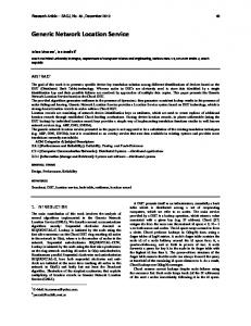
Corresponding services are called location-based services (LBS). The term “service” is commonly used in network domains. According to the World Wide Web Consortium2 (W3C) the definition of a web service is that: Web services provide a standard means of interoperating between different software applications running on a variety of platforms and/or frameworks. The key point in this definition is that web services enable heterogeneous application inter-working. The term location-aware application describes an application which works offline such as a car navigation system. Due to the common understanding of the term LBS and the trend towards ubiquitous service access we use the term LBS relating to both types of services and/or applications in this thesis. The kinds of LBS services offered can be classified into two main types [3GP04] as illustrated in Figure 2.1a: Services which are triggered by an application service provider when a user arrives or enters a certain geographic location, e.g. push advertisements in a shopping mall or localized weather warnings, are classified as type 1 services (also called “push” or “triggered services”). Services which are typically information services requested by a user from an application service provider, e.g. finding nearby restaurant/gas-stations or navigation services, are classified as type 2 LBS (so called “user-requested” or “pull services”). Type 1
Type 2
(a) Server-to-User Location Based Services
Type 3
(b) Peer-to-Peer Services with de-centralized location information management Figure 2.1 Location-based service classifications
The two types illustrated in Figure 2.1(a) are server-to-user LBS where location information is provided and managed by a central location platform provider, i.e. an approach followed by mobile operators primarily [OM04b]. Access to location information i.e. to 3rd party application providers, is only being made available through mobile operator network entities. A third type of peer-to-peer LBS (Figure 2.1b) 2
W3C: http://www.w3.org
Chapter 2 Fundamentals and new Perspectives on Location Service Provisioning
13
represents a different approach to type 1 and 2 LBS, in which location information is directly exchanged by communicating peers, but LBS can be still provided by a 3rd party. Stand-alone solutions such as in-car- or mobile PDA-based navigation using GPS and static geo-information data stored locally on the device for outdoor navigation can be seen as a decentralized location platform approach. The issue of (de-)centralized location information provisioning will be discussed in later sections of this chapter in more detail. The LBS classifications represented in Figure 2.1 give a short overview on recognized LBS types. A classification representing next generation LBS is presented in [KTL06]. Here, the classical LBS types are extended to include the different approaches and possibilities on providing a location service in different usage domains which will help define the requirements on future seamless location service architectures later on in this thesis. The extended LBS classifications are as follows: 1) Reactive and proactive LBSs: This corresponds to the type 2 interactive LBS (reactive) and type 1 triggered LBS on the occurrence of predefined events (proactive). 2) Self-referencing and cross-referencing LBSs: This distinguishes whether the user is processing his own location information (self-referencing) or that of another entity (cross-referencing). The latter case must consider privacy aspects of that entity, respectively. 3) Single-target and multi-target LBSs: The single target LBS considers location information in reference to an entity, whereas the multi-target LBS interrelates the location information of multiple entities, e.g. they are close-by, within the same building etc. 4) Central and peer-to-peer LBSs: This distinguishes between the centralized (Type 1 & 2) and decentralized (Type 3) approach on managing location information. 5) Outdoor and indoor LBSs: This refers to availability and relevance of the LBS, i.e. global (outdoor) availability and relevance, or only local relevance to a “closed” (indoor) environment. Items 1) to 3) help to distinguish between LBS type requirements on location information and user interaction mechanisms. Apart from user privacy and availability considerations on LBS, items 4) and 5) relate much more to location service architecture requirements. While item 4) has implications on the general location service architecture strategy, item 5) addresses the “seamless” location service availability question to be addressed in our later architecture discussion. Table 2.1 summarizes the discussed LBS classifications with corresponding LBS examples. Instead of classifying LBS as outdoor or indoor, it is more meaningful to talk about global or local relevance in terms of availability. Item 4) has been omitted since it relates more to the infrastructure rather than to the LBS requirements, although peer-to-peer benefits user privacy control in some of the listed cases [ZD05b]. An accuracy indicator has been included in each case. What becomes clear when looking at the various LBS types and requirements on location information delivery as well as accuracy, a single system capable of providing a location service meeting all requirements efficiently, at all times and at a reasonable cost is not very feasible. Since a majority of LBS involve location changes of both user and target(s), the complexity of such a system even increases if the location service
Chapter 2 Fundamentals and new Perspectives on Location Service Provisioning Category
14
Reactive vs. Proactive
Self. vs. Cross Reference
Single vs. multiple targets
Global vs. local relevance
Required Accuracy
Reactive
Self
Single
Local