VOL. 10, NO 21, NOVEMBER, 2015
ISSN 1819-6608
ARPN Journal of Engineering and Applied Sciences ©2006-2015 Asian Research Publishing Network (ARPN). All rights reserved.
www.arpnjournals.com
A MODIFIED EFFECTIVE PATH LENGTH FOR PREDICTING RAIN ATTENUATION BASED ON MEASUREMENTS IN PENANG-MALAYSIA Ali Kadhim Lwas1, MD. Rafiqul Islam1, Mohamed Hadi Habaebi1, Singh Jit Mandeep2, Ahmad Fadzil Ismail1, Jamal Ibrahim Daoud3 and Alhareth Zyoud1 1
Department of Electrical and Computer Engineering, University of International Islamic Malaysia, Jalan Gombak, Kuala Lumpur, Selangor, Malaysia 2 Department of Electrical, Electronic and Systems Engineering, University Kebangsaan Malaysia, Jalan Reko, Bangi, Selangor, Malaysia 3 Department of Science in Engineering, University of International Islamic Malaysia, Jalan Gombak, Kuala Lumpur, Selangor, Malaysia E-Mail:
[email protected]
ABSTRACT A modification to an effective path length for predicting rain attenuation in Malaysia is proposed in this paper. Due to the scarcity of actual signal measurements at high frequencies-bands in tropical climates make predicted models are key resource for generating rain attenuation. A modification to calculate the effective path length is introduced in the original model. A control parameter rho is also induced based on the rain intensity variations along the slant path. A new value is suggested according to measurements in Malaysia. The results showed that modified rain attenuation model has significantly improved the rain attenuation prediction in Malaysia. Keywords: effective path length, rain attenuation, prediction model.
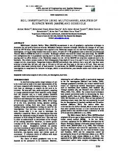
INTRODUCTION Knowledge about the outage probability of a satellite system is essential for any satellite communication system designer. Therefore, it is very important to determine the rain fade characteristics, and analyze the rain attenuation in-depth. Accurate estimation of rain attenuation leads to propose the appropriate and suitable mitigation technique for the rain effect. Any error in the estimation of rain attenuation leads to increase the outage probability and lost the satellite signal for some period of time [1]. Most of the available studies in the literature are conducted in temperate region where rain has different characteristics, thus, such results and analysis proposed by these studies will not be appropriate for tropical regions like Malaysia [2-3]. In temperate regions, the rain cell size is large and the rainfall is moderate while in the tropical regions the cell size is smaller and the rain is convectional [4-7]. The differences between temperate and tropical regions are not only in rainfall rate but also in the rain structure and spatial structure between the Earth base station and the satellite [8]. The rain height in temperate region is less than the rain height in tropical region where it reaches up to 10 km [9]. Evidently, the slant path of satellite signal between the Earth base station and the satellite is a function of the elevation angle. Therefore, the slant path in tropical regions will be subject to strong and higher rainfall rate than in temperate regions. Of course, not the whole path of the satellite signal will be subject to rain. The part of the path that is covered by rain is called the effective length as shown in Figure-1. Based on
previous studies, the effective length is a function of elevation angle, rain height, and rainfall rate. Based on the above description, therefore, the effective path length determination models proposed for temperate regions will not be accurate for tropical regions. Furthermore, the rain attenuation prediction models which are proposed based on the data from temperate regions will be unsuitable to be applied in tropical regions too. Therefore, and based on the above description, the effective path length determination models that proposed for temperate regions will not be that accurate for tropical regions. Furthermore, the rain attenuation prediction models which proposed based on data from temperate regions will not suitable also to be applied in tropical regions too. The objectives of this paper are to modify the equation used to calculate the effective path length, and to propose control parameters of variation intensity in Malaysia. To meet these objectives, rain rate and rain attenuation were measured concurrently at University Science Malaysia (USM) campus (5.17° N, 100.4° E) and were used to test the modified model. This paper shows very promising results for the rain attenuation prediction in tropical regions.
10096
VOL. 10, NO 21, NOVEMBER, 2015
ISSN 1819-6608
ARPN Journal of Engineering and Applied Sciences ©2006-2015 Asian Research Publishing Network (ARPN). All rights reserved.
www.arpnjournals.com respectively as shown in Figure-2 and can be determined by: Satellit
LA
°0 Isotherm height
HR Hs sin( )
(4)
HR Hs h sin( )
(5)
L
LB
HR Leff
θ
Hs
Figure-1. A diagram showing the propagation path, HR is the rain height and Leff is effective path length. PROPOSED MODIFICATION The total attenuation along slant path can be estimated as [10]:
A(dB) (dB / km) Leff
(1)
where the effective length Leff is the part of path length that is subjected to raining and the first term of Equation (1) is a specific rain attenuation over a kilometer and can be determined as [11]:
(dB / km) kRp
where theta (θ) is the elevation angle of slant path between Earth station and satellite, Hs presents the Earth station latitude and h is the thickness of the melting layer which is 0.36 km while HR is the height of rain and it can be estimated by [13].
H R h 0.36 km
where h0 is the 0°C isotherm height, for Malaysia is 4.5 km. The prediction rain attenuation model in Eqn. (3) depends on rain height and elevation angle to determine rain height length, while neglecting the rain intensity variations. The authors in [14] proposed model to compute the Leff based on rain height, elevation angle and the rain intensity variations. This model is adopted with some modification to calculate the effective length as following:
(2)
where k and α are related to the frequency and the polarization of the traversing signal and raindrop size distribution. To determine the effective length, some main parameters such as rain intensity, rain height and elevation angle were taken into consideration. However, Equation (3) presents prediction rain attenuation model of two layers as shown in Figure-2 and it is proposed to estimate rain attenuation at any time percentage by inserting the values of point rain rate exceeded Rp with a given probability and effective length [12].
Leff
1 R pL cos( )
B
B p
A k A R LA r k B R ( LB LA )
(3)
where � is a controlling parameter representing the rain intensity variations along the satellite path. In addition, the value of L in the above equation is proposed to LA as shown in Figure-2 for rain layer. In prediction rain attenuation model as explained in Equation (5) can be modified by replacing LA by Leff as in (8) and (LB-LA) = h/sinθ as shown in Figure-2 as follows:
A
A L A cos( )
1 Rp
A ln( R p ) cos( ) B
B
Nr k B R p The first term in Equation (3) is predicted rain attenuation for rain layer while second term presents rain attenuation for melting layer. LA and LB represent the raining path through rain layer and melting layer
(7)
ln( R p ) cos( )
A k A Rp A p
(6)
(8)
h sin( )
where N is defined as a binary operator that can be expressed as
10097
VOL. 10, NO 21, NOVEMBER, 2015
ISSN 1819-6608
ARPN Journal of Engineering and Applied Sciences ©2006-2015 Asian Research Publishing Network (ARPN). All rights reserved.
www.arpnjournals.com
HR HR
3
p
(9)
HR HR
P
2.5 Function Value
1 N 0
where HRp is proposed by [15] and given by:
1.5 1 0.5 0 0
0.01
0.02
0.03
0.04
0.05
(10)
The parameter (N) value in (9) determines the output of prediction rain attenuation model in (8). The model will consider the rain attenuation by both of rain and melting layer (N=1). On the other hand, the rain attenuation is only calculated for the rain layer (N=0).
0.06
0.07
0.08
0.09
0.1
0.11
0.12
0.07
0.08
0.09
0.1
0.11
0.12
0.07
0.08
0.09
0.1
0.11
0.12
0.07
0.08
0.09
0.1
0.11
0.12
-a2.5 2 Function Value
H R p 4.5 0.0005R
1.65 p
2
1.5 1 0.5 0 0
0.01
0.02
0.03
0.04
0.05
0.06
-b-
Function Value
2
1.5
1
0.5
0 0
0.01
0.02
0.03
0.04
0.05
Figure-2. Parameters diagram of two layers model of precipitation and Earth - satellite link geometry.
0.06
-c-
Function Value
1.5
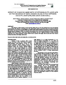
PROPOSED CONTROLLING PARAMETER The percentages of measurements rain rate are used in Equation (8) and compare with the measured values of rain attenuation for one year in order to establish the value of the parameter rho (�). The Octave software was used to solve (8) to determine the rho (�) value. Octave software is defined as a high level programming language; it has a capability for the numerical solution of linear and nonlinear problems .The appropriate rho (�) value for several measured data is found to be between 1/10 and 1/35 and the best fit for Malaysia is found to be 1/15. Maximum and minimum values of rho that fits different data measured are illustrated in Figure-3.
1
0.5
0 0
0.01
0.02
0.03
0.04
0.05
0.06
-dFigure-3. Different values of rho are explained in (a-d), (a) minimum and (d) maximum for measured data using modified model.
10098
VOL. 10, NO 21, NOVEMBER, 2015
ISSN 1819-6608
ARPN Journal of Engineering and Applied Sciences ©2006-2015 Asian Research Publishing Network (ARPN). All rights reserved.
www.arpnjournals.com COMPARISON AND DISCUSSIONS The receiver site was located at University Science Malaysia (USM). The antenna was pointed towards SUPERBIRD-C located at 144°E. The signal frequency of receiver was 12.255 GHz and it was horizontally polarized. The diameter of receiver antenna was 2.4 m. The elevation angle of slant path was 40.1° and the height of receiver site above sea level was approximately 57 m. The tipping bucket rain gauge was placed close the receiver antenna and its capacity was 0.5 mm per tip. One minute integration time was used to compute the rain rate. The time of measurements was close to 96% over one year. The complementary cumulative distributions of rain rate and took difference percentage of time change from 1% to 0.001% to generate prediction rain attenuation using modified model (8) and control parameter (rho=1/15). The complementary cumulative distribution of the real rain attenuation was compared with modified model and ITU. R. P.618-11 model as shown in Figure-4. The ITU-R model underestimates the measured rain attenuation throughout all percentages of time. The modified model agreed well with the measured signal. The measured rain attenuation, at 0.001 % and 0.01 % time percentage are 27.3 and 22.3 dB respectively; while the modified model values are 28 and 22.5 dB and the ITU-R model values 18.8 and 15.3 dB.
Time Percentage (%)
10
10
10
10
0
ITU-R P.618-11 Measured Rain Attenuation Predicted Rain Attenuation by Modified Model -1
-2
-3
0
2
4
6
8
10 12 14 16 18 20 22 24 26 28 30 32 34 36 38 40 Rain Attenuation (dB)
Figure-4. Complementary cumulative distribution of rain attenuation at 12.225 GHz: Predictions using the modified modeland ITU-R P.618-11. CONCLUSIONS This paper presents a modification to an effective path length for predicting rain attenuation from measured rain intensity in Malaysia. The method will be very useful due to the lack of real signal measurements at Ka and Vbands in tropical regions. A modification for the calculation of the effective path length is introduced in the original model. A control parameter (�) is also introduced to represent the rain intensity variations along the satellite path and a new value is proposed based on data measured in Malaysia. The proposed model was validated with
measurement and found to be accurate in predicating rain attenuation measurement on Earth-to-satellite link at Kuband in Malaysian tropical climate. ACKNOWLEDGEMENTS This work was funded by E-Science grant SF13002-0052 from Malaysian ministry of Science, Technology and Innovation (MOSTI). REFERENCES [1] Abdulrahman A. Y., Rahman T. A., Rahim S. K. B. A., Islam MD. R. 2010. A new rain attenuation conversion technique for tropical regions, Progress in Electromagnetics Research B, vol. 26, pp. 53-67. [2] Lwas A. K., Islam M. R., Chebil J., Habaebi M. H., Ismail A. F., Mandeep J. S., Zyoud A. and Dao H. 2014. Analysis of Synthetic Storm Technique based on Ku-Band Satellite Beacon Measurements in Malaysia, Advanced Computer and Communication Engineering Technology Lecture Notes in Electrical Engineering, vol. 315, pp. 121-128. [3] Lwas A. K., Islam M. R., Habaebi M. H., Ismail A. F., Abdullah K., Zyoud A. and Mandeep, J. S. 2014. Analysis of the Synthetic Storm Technique Using Rain Height Models to Predict Rain Attenuation in Tropical Regions. In: Computer and Communication Engineering (ICCCE), 2014 International Conference on. IEEE. pp. 220-223. [4] Dissanayake A., Allnutt J. and Haidara F. 1997. A prediction model that combines rain attenuation and other propagation impairments along earth-satellite paths. IEEE Transactions on Antennas and Propagation, vol. 45, pp. 1546-1558. [5] Mandeep J. S., Hassan S.I.S. , Ain M.F., Ghani F., Igarashi K., Tanaka K. and Iida, M. 2007. Rain attenuation model for South East Asia countries. IET Electronic Letters, vol. 43, pp. 75-77. [6] Pan Q., Bryant G. H., McMahon J., Allnutt J. E. and Haidara F. 2001. High elevation angle satellite to earth 12 GHz propagation measurements in the tropics. International Journal of Satellite Communications, vol. 19, pp. 363-384. [7] Suriza, A. Z., Islam, R. MD., Wajdi, A. K. and Naji, A. W. 2013. Proposed parameters of specific rain attenuation prediction for Free Space Optics link
10099
VOL. 10, NO 21, NOVEMBER, 2015
ISSN 1819-6608
ARPN Journal of Engineering and Applied Sciences ©2006-2015 Asian Research Publishing Network (ARPN). All rights reserved.
www.arpnjournals.com operating in tropical region. Journal of Atmospheric and Solar-Terrestrial Physics, vol. 94, pp. 93-99. [8] Lwas A. K., Islam, M. R., Habaebi, M. H., Mandeep, J. S., Ismail, A. F. and Zyoud, A. 2015. Effects of wind velocity on slant path rain-attenuation for satellite application in Malaysia. Acta Astronautica, Acta Astronaut. 117: 4024-407, doi.org/10.1016/j.actaastro.2015.09.008. [9] Mandeep J. S.,Tanaka K. 2007. Effect of atmospheric parameters on satellite link. International Journal of Infrared and Millimeter Waves, 28(10): 789-795. [10] I.T.U. R., P.618-11. 2013. Propagation data and prediction methods required for the design of Earthspace telecommunication Systems. Geneva. [11] ITU-R P.838-3. 2005. Specific attenuation model for rain for use in prediction methods, Geneva. [12] Matricciani E. 1996. Physical-mathematical model of the dynamics of rain attenuation based on rain rate time series and a two-layer vertical structure of precipitation. Radio Science, vol. 31, pp. 281-295. [13] ITU- R., P.839-0. 1990. Rain height model for prediction methods. Geneva. [14] Stutzman W. L., Dishman W. K. 1982. A simple model for the estimation of rain-induced attenuation along earth-space paths at millimeter wave lengths. Radio Science, vol. 17, pp. 1465-1476. [15] Bryant G. H., Adimula I., Riva C. and Brussaard G. 2001. Rain attenuation statistics from rain cell diameters and heights. International Journal of Satellite Communications. 19(3): 263- 283.
10100