International Journal of Spatial Data Infrastructures Research, 2012, Vol.7, 323-351
A multidisciplinary Spatial Data Infrastructure for the Mediterranean to support the implementation of the Marine Strategy Framework Directive Sergio Cinnirella1, David March2, Tim O’Higgins3, Carla Murciano4, Rafael Sardà5, Joan Albaigés4 and Nicola Pirrone1
1
CNR-Institute of Atmospheric Pollution Research, Division of Rende – Rende, Italy;
[email protected];
[email protected]
2
Consejo Superior de Investigaciones Científicas, Institut Mediterrain d’Estudis Avançats – Esporles, Spain;
[email protected]
3
Scottish Association for Marine Science (SAMS), Scottish Marine Institute – Oban, Scotland; Tim.O'
[email protected] 4
Consejo Superior de Investigaciones Científicas, Centre d’Investigació i Desenvolupament – Barcelona, Spain;
[email protected];
[email protected]
5
Consejo Superior de Investigaciones Científicas, Centre d'Estudis Avançats de Blanes – Blanes, Spain;
[email protected]
Abstract
The Marine Strategy Framework Directive (MSFD) adopted in 2008 aims to protect the marine environment through the holistic Ecosystem Approach (EA). The MSFD requires Member States to develop and implement cost-effective measures to achieve and/or maintain “Good Environmental Status” (GEnS). To this end, interested parties require a large amount of data and this data should be appropriately managed. This is particularly true for EA applications, where data
This work is licensed under the Creative Commons Attribution-Non commercial Works 3.0 License. To view a copy of this license, visit http://creativecommons.org/licenses/by-nc-nd/3.0/ or send a th letter to Creative Commons, 543 Howard Street, 5 Floor, San Francisco, California, 94105, USA. DOI: 10.2902/1725-0463.2012.07.art16
323
International Journal of Spatial Data Infrastructures Research, 2012, Vol.7, 323-351
can come from diverse sources, in diverse formats, and from several disciplines. Preliminary steps for supporting reliable multi-disciplinary analysis include data collection, data management, and the implementation of an interoperable sharing system. In an effort to implement this type of multidisciplinary analysis, a working group from the KnowSeas project (www.knowseas.com) created a Spatial Data Infrastructure for the Mediterranean Sea, designed to define and analyze the GEnS concept across various geographical scales. This article describes the implementation of this SDI, demonstrating how an interoperable system can provide strong support in implementing the MSFD under the EA, and how marine spatial planning can assist policymakers in the decision making process.
Keywords: Spatial Data Infrastructures, Marine Strategy Framework Directive, EUROGEOSS, DPSIR, Chemical pollution, Environmental Management, Ecosystem Approach, Web Services
1. INTRODUCTION The European Union’s Marine Strategy Framework Directive (MSFD) was adopted in June 2008 to protect the marine environment. To date, this directive forms the main environmental pillar of the European Union’s (EU) Integrated Maritime Policy (EU, 2008). Under the MSFD, EU Member States are required to use the Ecosystem Approach (EA) (MEA, 2005) to environmental management in an effort to achieve Good Environmental Status (GEnS) for their marine waters by 2020. The EA is characterised by the following elements: a multi-sectoral focus, the inclusion of ecosystem services within the decision making process, and the recognition that human and ecological systems are tightly coupled (Tallis et al, 2010). The GEnS descriptors for the MSFD are ambitious, covering many aspects of the marine environment. While some of these encompass aspects of the marine environment already addressed by existing Directives, others require additional research (Cardoso et al, 2010). These descriptors cover a mixture of environmental pressures and environmental states, and member nations are required to provide an initial assessment by July 2012. To implement the MSFD by using GEnS descriptors, Spatial Data Infrastructures (SDIs) should be designed, implemented, and endorsed in a multidisciplinary fashion. Marine SDIs are no longer a novelty, as they are well reported in existing literature and are acknowledged to be a key element in improving the management and protection of coastal and marine ecosystems (Drapeau, 2008). Thematic SDIs can cover navigation and marine infrastructures, as well as marine habitats and biodiversity (Fowler et al, 2010), but, most importantly, they
324
International Journal of Spatial Data Infrastructures Research, 2012, Vol.7, 323-351
reinforce the need for a cohesive and decisive management and administration strategy for coastal zones (Binns, 2004; Strain et al, 2006). When considering the objectives and requirements of MSFD, it appears that the steps toward the implementation process are strongly supported by an SDI, both for the initial assessment phase and for implementing a measurement program, as most processes involve a massive amount of information. Only such an approach can strongly support the definition of GEnS, a status that reflects a mixture of environmental and anthropocentric concerns and sets out a strict timeline for achieving these environmental goals. With the above in mind, we embarked on the design and implementation of multidisciplinary SDI for the KnowSeas project (www.knowseas.com) and with the support of EGIDA project (www.egida-project.eu). This paper describes the process and the results, including the planning of the SDI, the selection of key indicators, the management of diverse information, and an analysis of the problems that can arise when managing a shared resource, like the Mediterranean. In the process, this paper demonstrates how a multidisciplinary SDI can provide strong support towards the implementation of the MSFD. In conclusion, this paper discusses how such SDIs could enhance our capacity to create effective environmental management structures, engage communities, and nurture some of the areas of Societal Benefit outlined in the Global Earth Observation System of Systems (GEOSS). 2. POLICY FRAMEWORK The MSFD lists eleven qualitative descriptors for determining GEnS, which reflect a mixture of environmental and anthropocentric concerns. The MSFD also sets out a strict timeline for achieving these environmental goals and requires social and economic analysis as part of the initial assessment. This social analysis combined with the broad variety of descriptors represents an attempt to provide a more holistic understanding (i.e. assessment, planning, and management of any environmental system is based on multiple disciplines, to the greatest extent possible) of the marine environment, necessary to implementing an EA. The EA (and its application in social-ecological systems) is a relatively new paradigm for marine management, and the information required to put it into practice requires multidisciplinary inputs (Farmer et al, 2012). While environmental pressures and state-changes may be measured by an environmental scientist (e.g. nutrient fluxes, chlorophyll and chemicals concentrations), the changes in human welfare require input from environmental and ecological economists (e.g. values of marginal changes in environmental parameters, willingness to pay estimates and an application of ecosystem service concepts).
325
International Journal of Spatial Data Infrastructures Research, 2012, Vol.7, 323-351
This complex analysis can be done by utilizing the Drivers-Pressures-StateImpact-Response (DPSIR) framework, a widely-accepted and well-tested approach for the integrated analysis of social and ecological systems (IMPRESS, 2002; Borja et al, 2006, Langmead et al, 2008; Knudsen et al, 2010; Atkins et al, 2011). For the purposes of the KnowSeas project, the framework has been modified using the word “Welfare” instead of the term “Impact” – using it as a synonym to make a clear distinction between environmental impacts or Statechanges and the human Welfare changes it causes (Cooper, 2012). Henceforth we refer to this framework as DPSWR. Drivers are economic and social forces that result from government policies, markets, and private industry. Pressures are the ways these Drivers place demands upon ecosystems causing alterations. These alterations lead to an environmental State. Welfare-changes are those changes in human welfare that are attributable to environmental State-changes. The management Response to a particular problem may then be directed towards any of the other elements (D, P, S or W) in an effort to achieve a balance between the benefits of economic and social development and the costs to an ecosystem. This framework can help us analyze inter-related systems and link environmental, social and economic outcomes by establishing causal links between such system components. A DPSWR framework is based on a selection of key indicators that form the basis of our analysis. In our case, we adapted this framework to group indicators in a way that made for an effective causal-link analysis. The EU has required the EA and MSFD to use environmental and socioeconomic information with geographic components (e.g. longitude and latitude) (Bertram and Rehdanz, 2012). The varied and multi-sectoral nature of the GEnS descriptors, combined with the requirement for social and economic components, presents a considerable challenge for environmental decision makers. Any efficient implementation of the MSFD requires easy access to environmental, economic, and social data, but the implementation timeline has coincided with an era of unprecedented economic change. This challenge requires a broad variety of interdisciplinary expertise, and this combination of factors provides a unique challenge for the design and implementation of efficient SDIs. 3. A SHARED SEA WITHOUT SHARED DATA The Mediterranean is “shared” more than other seas, as it is surrounded by 21 coastal states that often exercise their right to extend national jurisdiction over the sea’s waters (Figure 1). A few of these states have designated areas as “Exclusive Economic Zones,” resulting in several cases wherein highly-productive sea areas lie much closer to the coasts than they do in other seas and oceans. This large number of highly-productive areas require an enhanced level of cooperation between coastal states, undertaken to tackle environmental threats and ensure the sustainable use of resources such as fish stocks.
326
International Journal of Spatial Data Infrastructures Research, 2012, Vol.7, 323-351
Figure 1: The Jurisdictional Waters of the Mediterranean
Source: Modified from de Vivero, 2009
Countries surrounding the Mediterranean share approximately 2.5 million km 2 of sea, of which 652 507 km2 lie within Member States’ jurisdictions (~25.2%). In this legal context, each Mediterranean country participates in different marine protection initiatives, which range from international conventions (e.g. the United Nations Convention on the Law of the Sea, UNCLOS; the Convention on Wetlands, RAMSAR; the Convention on Biological Diversity, CBD; and the Basel Convention) to regional initiatives (e.g. the United Nations Environment Programme-Mediterranean Action Plan, UNEP-MAP; the Initiative to substantially reduce the pollution of the Mediterranean Sea by 2020, H2020). Not all of these countries are within Europe’s legislative jurisdiction (e.g. they do not have obligations under the MSFD). This has important implications for the conservation and management of marine environments. In particular, there are broad differences in the various measurement and monitoring programmes, as well as in different data collection and management practices. These differences may result in difficulties in assessing environmental status at the regional sea level, as is required by the Directive.
327
International Journal of Spatial Data Infrastructures Research, 2012, Vol.7, 323-351
With the launch of the Regional Seas Programme in 1974, Mediterranean countries first adopted an Action Plan, which was then revised in 1995, and finally enforced in 2004. Seven Protocols addressing specific aspects of Mediterranean environmental conservation were adopted, creating an international legal framework for the Mediterranean region. Most of these require monitoring and data management actions in their implementation and enforcement. To some extent, all initiatives have or are contributing to the establishment of central databases, by using reference standards or dedicated formats to store both data and metadata (see, for example, MEDPOL, The Mediterranean Oceanic Data Base (MODB), the Mediterranean wetlands initiative (MEDWet), MyOcean, SeaDataNet and the website of the European Environment Agency). However, not all these initiatives adopt common standards or use metadata. In addition, many research projects, including past and ongoing national and international projects, do not create public databases or metadata, despite the added value such products would provide (and despite the public funding they receive). Sporadic project funding for research groups, the diversity of institutional structures, and the variations in technical capabilities are all obstacles to making data interoperable. Where funding is short, institutions are more likely to be possessive of their data-holdings, and many institutions lack the relevant technical expertise to harness emerging technologies for creating public metadata systems. The importance of sharing environmental information has been recognized by the EU in their Communication towards a Shared Environmental Information System (SEIS). This initiative aims to establish an integrated and shared EU-wide environmental information system, through a collaboration amongst Member States, the European Commission, and the European Environment Agency (EEA). In addition, the launch of initiatives aimed to discover and implement data infrastructures (e.g. Marine Ecosystem Dynamics and Indicators for North Africa – the MEDINA project) shows that data sharing technologies are establishing a strong foundation, with the potential to deliver major benefits to society. However, different practices of data classification and reporting continue to complicate data access and reduce the utility of the data for cross-border analyses. Data sharing can strengthen decision making by providing real-time information when determining the most appropriate course of action, or when it is desirable to increase public awareness of specific environmental topics. A holistic and consistent Europe-wide methodological approach to multidisciplinary spatial data is essential to efficient and economical management of European social and ecological systems. It is also essential to the implementation of the MSFD. To this end, information held in an SDI can be particularly powerful, especially if the SDI itself is part of a larger network. An over-arching system connecting SDIs can provide a wider range of decision-support tools, as well as access to a broad
328
International Journal of Spatial Data Infrastructures Research, 2012, Vol.7, 323-351
range of information. Such a global system is becoming a reality with GEOSS, a federated system in which registered services and components allow users to access, search, and then use different data, information, tools, and services. GEOSS components include observation systems, data processing systems, dissemination systems, capacity-building systems, and other initiatives. GEOSS services provide functionalities to these components. SDIs participating in these networks will benefit from (GEO, 2007):
sharing costs for data collection, data processing, data distribution and data archiving; gaining worldwide exposure to potential users and collaborations that could enhance the products and services they offer; improving their existing products and services, or acquiring entirely new cross-system synergies or innovations; optimizing shared observational strategies, and filling cooperative gaps, thereby improving coverage and continuity in the data; capacity-building to contribute to and exploit already existing Earth observation data and information, thereby enhancing the system’s applications that yield benefits to its end-users.
4. GENS DEFINITION FOR THE MEDITERRANEAN While the MSFD poses a significant challenge to environmental scientists and decision makers, several existing processes are of direct relevance to its implementation. GEnS must be determined on the basis of eleven qualitative descriptors, and these reflect a mixture of environmental and anthropocentric concerns using criteria and methodological standards (on the good environmental status of marine waters) as reported in the Commission Decision of 1 September 2010 (2010/477/EU; hereafter referred to as COM-Dec) (EU, 2010). COM-Dec states that, for most criteria, the required assessment methodologies need to be based on (or take into account) existing Community legislation. In COM-Dec, qualitative descriptors are accompanied by a number of related indicators that are useful in assessing environmental status (Piha and Zampoukas, 2011). COMDec requires that they be combined, resulting in an overall assessment of environmental status. To this end, easily accessible data could provide an invaluable first step toward a regional harmonisation of the MSFD, and SDIs have a clear role to play in facilitating easy access to this data, with many examples emerging in the last few years.
329
International Journal of Spatial Data Infrastructures Research, 2012, Vol.7, 323-351
5. SDIS AS FUNDAMENTAL TOOLS FOR MARINE AND COASTAL MANAGEMENT An SDI can be described as “...the underlying infrastructure, often in the form of policies, standards and access networks that allows data to be shared between and within organisations, states or countries.” (Strain et al, 2006). In practice, an SDI uses machines and tools oriented to archive, access, query, discover, and export metadata and spatial data. To fulfil its “natural” propensity for interoperability, an SDI should adopt widely-used, commonly-adopted standards. Effective marine governance and administration is reliant upon access to spatial information (Ting and Williamson, 2000; Barry et al, 2003). One of the main advantages of an SDI for integrated environmental management is easy data accessibility, which not only enables scientific analyses, but facilitates fast and informed decision making (Cömert et al, 2008, Douven, 2003; Pepper, 2003; Binns, 2004). In addition, any collaboration between different institutions in the development of a dedicated SDI allows those institutions to benefit from the resultant networking, which in the long term, supports the accumulation of spatial data, models, and expertise (Tolvanen and Kalliola, 2008). Thus, clearly there is an opportunity to improve the management of marine and coastal environments through better access to, and improved sharing of, spatial information (Strain et al, 2006; Sardà et al, 2009). Until recently, SDIs were focused mainly on the management of coastal zones (Strain et al, 2006; Williamson et al, 2006) butrecent adoptions of marine spatial planning (MSP) processes – those that attempt to ensure the sustainable ecological use of socio-economic services that oceans provide (Douvere and Ehler, 2009a) – require the availability and analysis of multidisciplinary data. Today, there are many current examples of SDIs that support marine management. There are several initiatives currently underway at the global level. Of major importance is the involvement of the International Hydrographic Organisation (IHO) in developing a Marine SDI (IHO, 2012). In addition, several US states (e.g. Massachusetts, Rhode Island, Oregon), use complex data frameworks that include information on marine habitats and biodiversity, human use, and the geology of the seafloor. Similar efforts are being undertaken on the international level in Belgium, the Netherlands, and Germany (Douvere and Ehler, 2009b; Fowler et al, 2010). The U.S. Integrated Ocean Observation System (IOOS) is another example of a complex system that provides tools for tracking, predicting, and managing data, products, and services for ocean, coastal and Great Lakes environments (IOOS, 2012).
330
International Journal of Spatial Data Infrastructures Research, 2012, Vol.7, 323-351
Japan has recently launched a recent prototype that integrates and provides marine-related information aimed at supporting marine management (Muto et al, 2010). In this case, a Marine Spatial Data Infrastructure allows users to browse data on bathymetry, sea/undersea names, lighthouses, alongside information on rights, interests, and responsibilities throughout the ocean domain. This prototype integrates multiple services, such as providing water chemical parameters by connecting to a WMS server and then providing MODIS Sea Surface Temperatures. In a bi-lateral collaboration, South Africa and France have implemented a geospatial node (Drapeau, 2008) aimed at studying spatial and temporal relationships between the different components of ecosystems, with foci that range from general environmental factors to more-specialized understandings of phytoplankton, zooplankton, and pelagic fish (their distribution and recruitment) and their predators and/or competitors. The Australian Ocean Data Centre Joint Facility successfully bid to develop the eMarine Information Infrastructure (eMII) for the Integrated Marine Observing System (IMOS). eMII provides a single integrated framework for data and information management, discovery, and access for the IMOS nodes. eMII is developing a distributed model to manage, host, and archive the data (raw and processed) from the IMOS nodes. It will also develop standards, protocols, and systems for integrating the data into a compliant framework and to provide the tools to allow its end-users to access and utilize the data (AODC, 2012). At the European level, Institut Français de Recherche pour l'Exploitation de la Mer (IFREMER) manages Sextant, a georeferenced marine data server (IFREMER, 2012). This SDI shares information to support issues like biodiversity, renewable energy at sea, the integrated management of coastal zones, fisheries, the coastal and deep-sea environments, exploration, and exploitation of the seabed. The SDI meets the technical interoperability requirements of the INSPIRE European Directive, and is based on both Open Geospatial Consortium (OGC) and ISO TC211 standards for accessing and disseminating geospatial data. In addition, the EMECO Datatool (EMECO, 2012) is part of the European Marine Ecosystem Observatory Initiative and is a suite of web-based tools that enable rapid integration and visualisation of multi-platform, multi-parameter, and multi-national data. The EMECO Datatool is mostly oriented to eutrophication assessment in the northern European seas but, at present, no metadata has been released. In addition, SeaDataNet (an Infrastructure on oceanographic data) is a distributed Marine Data Management Infrastructure for the management of large and diverse sets of data deriving from in situ and remote observation of the seas and oceans (SeaDataNet, 2012).
331
International Journal of Spatial Data Infrastructures Research, 2012, Vol.7, 323-351
At the Mediterranean level, specific tools have been developed for identifying candidates to be Specially Protected Areas of Mediterranean Interest in the open seas (including deep seas) (UNEP-MAP-RAC/SPA 2010). It is important to note that this system is far from an SDI as it is defined here (Strain et al, 2006), as it holds data on habitats and species ecology, human activities, resources, biotic and abiotic factors but lacks data-sharing capabilities. In general, all the Northern Africa Countries have yet to develop and implement SDIs, and they have had particular problems addressing communication and education challenges. It is possible that they have had no involvement with the European policies and legal frameworks that exist for the sea that they share (Smith and Dallemand, 2003) but more work is needed in this area to updating these findings from almost ten years ago. The above examples reflect the belief that these initiatives will improve marine and coastal management through a multidisciplinary (i.e. holistic) approach. From this point of view, the Sustainable Development Strategy for the Seas of East Asia (SDS-SEA), Integrated Coastal Zone Management (ICZM), and the 3rd United Nations Convention on the Law of the Sea (UNCLOS) can be considered as either compelling examples of this holistic approach or examples driving the adoption of a multidisciplinary approach. Based on this type of analysis, we developed a specific SDI that integrated social and ecological information relevant to the Mediterranean. Planned to facilitate an EA and implementation of the MSFD, this SDI utilized a GEnS definition through the DPSWR framework. This novel approach has allowed our SDI to integrate all existing environmental, social, and economic information that is available for marine status evaluation under the EA. In addition, this SDI was build up on process-based initiatives instead of productoriented as it was based on a voluntary partnerships and multi-sectoral collaboration. The process of engaging organizations across Europe already from the drafting stages and giving them a leading role in shaping the infrastructure is in line with best practice and the literature on participatory approaches, which can guide the selection of appropriate decision support methods and tools (Craglia and Onsrud, 2003). Moreover the establishment of a scientific network of key actors in different countries and thematic areas provides an opportunity for the long-term sustainability and use of the infrastructure. At the same time it is necessary to recognize the complex challenges that such an approach entails and the perspective of its contribute to GEOSS, a de facto sustainable programme. The SDI we developed was based on the idea that the adoption of the EA (and implementation of the MSFD) requires a variety of spatially-explicit ecological and social data to be made available to decision makers in a rapid and easily-
332
International Journal of Spatial Data Infrastructures Research, 2012, Vol.7, 323-351
accessible way. As marine management requires multiple spatial scales, such data should also be available in a similar way – across the scales most suited to managing specific locations or within specific eco-regions. This data collection and management is the basis for both marine environmental assessment and a GEnS definition. We planned to use this opportunity to develop innovative products and services based on the requirements of the collected data, by improving data standards (i.e. metadata, formats, nomenclature, information on precision and accuracy), and by providing wider access to quality-checked, rapidly-available coherent data (EC, 2010). While our SDI can provide the technical framework for implementing exactly these products and services, the data themselves are also fundamental in developing effective decision support systems and improving efficiency and effectiveness in actions that involve citizens. 6. IMPLEMENTATION OF THE SDI 6.1.
Requirements to Implement the SDI
Consistent with the definition of an SDI, we can establish a minimum set of components related to geospatial data management that work together to match user requirements. An effective SDI should have all of the following, if it is to facilitate ease-of-use and interoperability; and if it is to be used to support marine management (GSDI, 2009):
Policies and Institutional Arrangements: governance, data privacy and security, data sharing, cost recovery, standards; People: capacity building, cooperation, outreach; Data: single/distributed data storage for geospatial data and metadata; Technology: hardware, software, networks, databases, technical implementation plans.
With the above in mind, the SDI architecture was developed. 6.2.
Architecture
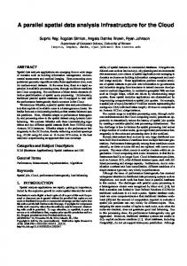
The SDI architecture consists of three different logic levels: the Data Storage Layer (DSL), the Business Logic Layer (BLL), and the Application Layer (AL) alike developed for a different environmental compartment (Figure 2) (D’Amore et al, 2011; D’Amore et al, 2012). The core of the system is represented by the Database Management System (DBMS), which holds vector geospatial information and functional data (e.g. users’ roles, credentials on datasets). The DBMS represents the DSL in the SDI architecture. It stores metadata and geographic data in separate databases to maintain a different logic structure for each type of data. It is accessed by BLL 333
International Journal of Spatial Data Infrastructures Research, 2012, Vol.7, 323-351
components, or it can be accessed in a secure way. Additional databases are dedicated to functional tasks by applications that perform data integration or system management. Figure 2: The SDI Architecture with the Data Storage Layer (left) the Business Logic Layer (centre left) and the Application Layer (right) Data Storage Layer
Application Layer
Business Logic Layer
Service broker
Geodatabase
GI-cat
Interfaces
WFS
Desktop GIS
Map server Geoserver
WMS
Catalog server Geonetwork
Thesaurus
WCS
EARTh
GeoInt File system
User-interface
WebGis
CSW
GEOInt
Currently, raster data are stored in the File System and handled directly by the map server. We adopted this approach because of constraints imposed by the open-source geodatabase (i.e. Postgis) that cannot directly handle raster information. In the near future, we hope to manage raster information using Data Access Objects (DAOs), which are objects that provide an abstract interface to access a database. DAOs are used in Software Engineering to decouple storage systems from software layers (D’Amore et al, 2011), making independent important parts of an application that can be expected to evolve frequently. Changes in business logic can rely on the same DAO interface, while changes to persistence logic do not affect DAO clients as long as the interface remains correctly implemented. Modifications made to the DAO implementation without altering other decoupled modules of the application is the principal expected benefit of use of DAO. All server components that perform metadata editing, data management, map creation, and data dissemination are in the BLL. Among them, the map server is used to export data through OGC compliant services and the metadata server is used to manage metadata and its related catalog. Server components export OGC Web Services (OWS) such as Web Feature (WFS), Web Map (WMS), Web
334
International Journal of Spatial Data Infrastructures Research, 2012, Vol.7, 323-351
Coverage (WCS) and Catalogue Services for the Web (CS-W), through the Hypertext Transfer Protocol (HTTP). The BLL adopts components that are useful in exploiting data stored in the DSL. It does so in order to export OWS to the AL, which represents a set of tools oriented to final-users. This container holds Desktop Geographical Information Systems (GISs), WebGISs, Metadata viewers, and a data downloader. 6.3.
System Implementation and Interoperability
The SDI architecture has been implemented using open-source components that fully match the requirements listed above. The main open-source components that perform the requested tasks include:
Geoserver (Geoserver, 2012), a map server that exports OWS. These services can be used directly by end-users in complex Service-Oriented Architecture (SOA) systems or geo-portals built with Web technologies. OGC services are also used by the following tool to integrate metadata with maps and other geographic data; Geonetwork (Geonetwork, 2012), a tool used to manage metadata. Metadata are exported via the CS-W 2.0.2 protocol, which is the basis for integrating the SDI into complex systems. This tool allows links to be made with Geographical Services (such as WMS) and correlations with different (even unstructured) data sources; EARTh (Plini et al, 2009; EARTh, 2012), the Thesaurus contained within Geonetwork in order to support the metadata editor process; GI-cat (Nativi et al, 2009; GI-cat, 2012), a Service Broker used as a collector for Geographic Web Services. It supports several protocols including WMS, WFS, Thematic Realtime Environmental Distributed Data Services (THREDDS), CS-W and accepts a wide variety of inputs. GI-cat extracts information and exports it in a standardized protocol as CS-W, and is linked directly with Geonetwork to export metadata and integrate the SDI into a more complex Systems of Systems like those constructed within GEOSS.
Novel aspects found in this selection of open-source components include i) a tight integration among components that can be easily realized, and ii) a potentially larger number of users that can check the code and establish a system with a very small economic commitment. These two simple aspects of the project have the potential to be good catalysts that can foster the wide-spread implementation of SDIs. The SDI was implemented in two separate iterations, the first covering the entire Mediterranean including the DPS and R indicators for mercury, and the second
335
International Journal of Spatial Data Infrastructures Research, 2012, Vol.7, 323-351
being restricted to the Gulf of Lions. In the second iteration we analysed elements for the whole DPSWR cycle. We adopted this approach because the geographical scale of the first iteration included data at the regional level, while the second was much more focused on decision making. We also adopted this strategy for practical reasons; while the second iteration focusing on the Gulf of Lions was the “official” version that demonstrated to KnowSeas participants how the system worked, the more comprehensive first iteration focused on “the big picture” of marine pollution throughout the entire Mediterranean, and was designed to be part of the permanent infrastructure of GEOSS. 6.4.
Indicator Selection and Database Compilation
At Mediterranean level, some studies have addressed the environmental consequences of Drivers like shipping, commercial fishing, tourism, and industrial production by focusing on issue-specific case studies (Hildering et al, 2009). Here, we present a summary of two such case studies for the Mediterranean, discuss their relevance to the MSFD, and identify the relevant Pressures and indicators. In general, we compiled our database with the overall aim to develop a broad, multi-issue, conceptual model for the Mediterranean Sea. As it needed to follow the DPSWR approach, we also considered:
selecting issues with reference to change in biodiversity, invasion of new marine species, change in the food web and chemical pollution; developing the cause-effect conceptual model for selected issues; defining the indicators list; assessing Pressures and State-characterization for the Mediterranean Sea and its basin.
The Ancillary information that we collected came in a wide variety of possible formats; from raw geographical tables to structured works in GIS formats. Existing datasets endorsed by public institutions such as the European Commission (as a Geographical Information System at the COmmission - GISCO - Database, a EUROSTAT service to manage and disseminate geodatabases), the FAO, and the EEA network EIONET (European Environment Information and Observation Network) aided in data compilation. Data from past and ongoing EU projects were also useful, as were ancillary datasets found in geoportals or obtained from data distributors. Based on this information, the study went on to examine SDI development in the Mediterranean from two perspectives: for the sea as a whole for one issue and in a cross-border context, illustrated by two case studies.
336
International Journal of Spatial Data Infrastructures Research, 2012, Vol.7, 323-351
7. SELECTED CASE STUDIES 7.1.
Case Study: Mediterranean
A Mediterranean-wide SDI was developed within a KnowSeas Work Package focused on heavy metal pollution, namely mercury. Major environmental and health problems associated with mercury derive from high concentrations of organic mercury in fish (Sprovieri et al, 2010). The distribution of mercury concentrations within fish are complex because fish-mercury concentrations vary with a fish sample’s characteristics. Among species, fish-mercury concentrations tend to increase with trophic level (MacCrimmon et al, 1983; Suns et al, 1987; Cope et al, 1990; Kim and Burggraaf, 1999). To assess the environmental status of marine waters and biota with respect to mercury contamination, we moved toward the identification of Pressures. Mercury in water and biota was analyzed to discover any correlation and find bioaccumulation trends along Trophic Levels (TLs). Finally, concentrations were compared with quality standards as established by the Directive 2008/105/EC on Environmental Quality Standards (EQSD). To this end, indicators related to mercury contamination were collected and data are particularly focused on GEnS descriptor numbers 8 and 9 (contaminants and seafood contaminants) (Table 1). The following are the major datasets collected for the assessment and contained in the SDI:
MEDPOL, a dataset collected under the Mediterranean Pollution Programme a scientific and technical component of the Mediterranean Action Plan/Barcelona Convention. It holds data and information on contaminant levels in different marine matrices (UNEP/MAP, 1996); MLI, a dataset collected from scientific publications (in a collaboration between the CNR-IIA and the Jožef Stefan Institute). It holds information on mercury in different marine matrices, and, where possible, has been geolocated; the RNO, the dataset established for the chemical surveillance of the French coastal zone; the SIDIMAR,the dataset established for the chemical surveillance of the Italian coastal zone; MERCYMS and MEDOCEANOR, datasets of measurements of mercury in marine waters collected during several cruise campaigns (www.iia.cnr.it).
337
International Journal of Spatial Data Infrastructures Research, 2012, Vol.7, 323-351
Table 1: Indicators for the Mediterranean Case Study (for State indicators, Relationship with the Eleven Descriptors of the MSFD are Presented) Descriptor number - Layer rd Nuts 3 level Coastlines Jurisdictional boundaries Marine ecoregions Basins Urban areas Airports Crude oil pipelines Ferries routes Highways Ports Rivers Mercury deposition for 1995 Mercury deposition for 2000 Mercury deposition for 2005 River total mercury load 8 - Inorganic mercury concentrations in water
DPSWR Ancillary Ancillary Ancillary Ancillary Ancillary Ancillary D D D D D D P P P P S
9 - Inorganic mercury concentrations in fish
S
8 - Organic mercury concentrations in water 9 - Organic mercury concentrations in fish 8 - Inorganic mercury concentrations in sediments Water Framework Directive (WFD), MSFD implementation areas Fisheries Restricted Area
S S S
Source EUROSTAT EEA, ISPRA de Vivero, 2009 EEA EEA EEA EEA EEA EEA EEA EEA EEA MSC-E MSC-E MSC-E UNEP/MAP MLI, RNO, SIDIMAR, MERCYMS MLI, RNO, SIDIMAR, MEDPOL MLI, MERCYMS MLI, MEDPOL MLI, MERCYMS
R
EC
R
Marine protected areas
R
General Fisheries Commission for the Mediterranean (GFCM) World Database on Protected Areas (WDPA), Abdulla et al, 2008
The DPSWR framework helped the selection of indicators, which belong to different domains (e.g. ecological, economic). Additional ancillary datasets have also been collected and stored in the SDI. These were included to improve understandings of the mercury issue at a regional level. These datasets include infrastructures (e.g. ports, roads, ferries routes, pipelines), jurisdictional borders
338
International Journal of Spatial Data Infrastructures Research, 2012, Vol.7, 323-351
(e.g. marine eco-regions, fish areas) and natural systems (e.g. bathymetry, rivers, watersheds). Once collected, all datasets were checked for discrepancies between location and geographical coordinates. After that, TLs were associated with each organism by means of information retrieved from the Sealifebase (www.sealifebase.org), a database on sea life, and each record was allocated to a marine eco-region. Indicators taken from the WMS were then correlated with the Pressure and State components of the DPSWR, making the SDI well-suited to supporting assessment under the MSFD. At the end of the process we developed a viewer to show mercury concentration in sediments, water, and biota (Figure 3). For example, the viewer helps us compare these concentrations with thresholds as established in the EQSD (Directive 2008/105/EC) and the assessment criteria for mercury in biota used in the 2008/9 Co-ordinated Environmental Monitoring Programme (CEMP). Figure 3: An Example of the SDI Viewer presenting Mercury Concentrations in Biota in the Mediterranean Basins from 1976-2010
7.2.
Case Study: Gulf of Lions
Marine pollution is one of the main problems for the entire Mediterranean, but it is more acute within the domain of the Gulf of Lions (in the NW Mediterranean). In this case study, we used DPSWR to assess eco-toxicological pollution from organochlorines in the trophic web. As before, we used an holistic approach. Bioaccumulation of Polychlorinated biphenyl (PCB) and dichlorodiphenyltrichloroethane (DDT) can have direct and indirect effects on marine organisms. These effects vary across different trophic levels, as seen in filter feeders (e.g. mussels), pelagic fish (e.g. anchovy and sardine), or top-
339
International Journal of Spatial Data Infrastructures Research, 2012, Vol.7, 323-351
predators such as marine mammals. At the same time, these effects on biota can have consequences for human health or human activities (e.g. fisheries, aquaculture and tourism). Measures to control marine pollution have been in effect since organochlorines were banned in the 1970s, and current legislation aimed at preserving biological resources exists at different organisational levels, in different regional agreements, and in different monitoring programs. We used this case study to develop a thematic SDI-approach specifically focused on the MSFD in the Gulf of Lions. Shared between Spain and France, the Gulf of Lions is a good trans-boundary case study because only two countries are involved and they both from the EU. Spain and France share common EU policies (e.g. INSPIRE, MSFD, WFD, EQSD), but also differ on national and local levels. The main issues we faced in building this thematic SDI were: 1) allowing for different types of indicators to be computed between countries, 2) accounting for data licenses from different sources of information, 3) accounting for a lack of complete OWS implementation by the different cartographic producers in both countries, 4) allowing for different language issues (Spanish, French, English). We classified the datasets and the indicators collected using the DPSWR approach, and their relationship with the eleven descriptors from the MSFD is described in (Table 2). Table 2: Indicators and their Classification based on the DSPWR Framework (for State Indicators, we also report Relationship with the Eleven Descriptors in the MSFD) Descriptor number - Layer Land use Bluefish catch (S. pilchardus and E. encrasicolus) Mussel (Mytilus galloprovincialis) catch 9 - PCB and DDT in M. galloprovincialis 3 - Bluefish stocks (S. pilchardus and E. encrasicolus) 1 - Presence of S. coeruleoalba 1 - Pollution levels in tissues of S. coeruleoalba Income/port Fishery subsidies Areas under WFD, MSFD jurisdiction Restricted Fishery Areas
340
DSPWR D P
Source EEA Gencat, France Agrimer
P S S
France Agrimer Ifremer, MEDPOL GFCM
S S
EEA Aguilar and Borell, 2005; Castrillon et al, 2010 Gencat, Agrimer Fishsubsidy.org EU, 2000; EU, 2008 GFCM
W W R R
International Journal of Spatial Data Infrastructures Research, 2012, Vol.7, 323-351
Following the interoperable standards of the SDI, users can access the data contained in the geodatabase and combine it to produce thematic maps. An example of this capability is presented in Figure 4, where we synthesized different datasets in order to illustrate the different indicators we presented in Table 4. Figure 4: Map of the DPSWR Framework representing Indicators related to Corals (C. rubrum) and Seagrass (P. oceanic).in the Gulf of Lions
8. CONCLUSION 8.1.
Needs and Gaps
The eleven descriptors for GEnS assessment under the MSFD pose a significant challenge to scientists and policymakers alike. In our work developed at the Mediterranean level, we found that some of the linkages (i.e. causal links) between Drivers and the Pressures causing changes in environmental States are well known and studied, whereas others remain research challenges. Understanding these linkages should continue to be a priority in marine environmental science research, not only at the Mediterranean level, but in general. Analysis of these linkages should push data collection and sharing forward, as it is essential for informed decision making and is a necessity for regional implementation for the MSFD. The regional management of European seas poses further difficulties, as effective management must overcome the differences in languages, cultures, and existing practices within each nation. SDIs are a promising and rapidly-developing tool to overcome these problems, and they have the potential to revolutionise environmental management. Shared information based on data and metadata will only improve as the adoption of
341
International Journal of Spatial Data Infrastructures Research, 2012, Vol.7, 323-351
standards and multi-language thesauri increase participation in this interoperable community. While the implementation of the MSFD is required of each EU member state, on a regional basis, the Mediterranean requires a special focus due to the diverse cultural, economic, social, and governance conditions that arise in the surrounding nations. At present, few countries monitor all the key indicators stipulated in the GEnS descriptors, and monitoring has been more focused on specific well-known environmental problems or based on scientific/local criteria (e.g. phytoplankton). In this respect, a regionally-integrated monitoring programme that takes into account ecological objectives, operational objectives, appropriate indicators, and targets for GEnS, needs to be established. All monitoring activities should be integrated within a single, well-defined approach, to achieve a particular level of environmental quality. Moreover, the SDI can identify gaps and overlaps and it can include historical and ongoing monitoring campaigns, thereby making visible gaps and redundancies in the sampling points. The design and implementation of this type of SDI is becoming more common, but they remain far from being fully operational and fully integrated, as was found in our cross-boundary example. This lack of integration can be attributed to existing national policies on data sharing, and differences in monitoring resolution, data, and collection. In addition, metadata are frequently absent or do not follow existing standards. Adoption of agreed-upon standards is one means of achieving operational sustainability in SDIs, facilitating data and metadata retrieval by means of service broker tools. 8.2.
Capacity Building, Community Engagement and SBAs Impact
For SDI implementation, capacity-building is another important technological challenge. Capacity-building also strengthens our knowledge of ocean management, as it requires different types of technological, human, and financial capacity (Rajabifard and Williamson, 2004). Achieving a GEnS and a sustainable use of marine ecosystems are the primary objectives of MSFD. To do so, MSFD aims to bring an EA to the marine environment. A practical application of the EA and the sustained delivery of ecological services in Europe’s seas are limited in two major ways: i) by a lack of comprehensive datasets, analytical tools, and techniques that work at appropriate spatial and temporal scales; and ii) by the absence of a clear institutional managerial framework and/or leadership aimed at reducing the environmental impact of human activities on those systems (Sardá et al, 2009). Both components (tools and frameworks) are necessary in order to synthesise existing
342
International Journal of Spatial Data Infrastructures Research, 2012, Vol.7, 323-351
information, to apply sustainable ecosystem services, to maintain ecosystem integrity, and to pursue the ultimate goal of obtaining GEnS in all the Member States in this marine environment. As a consequence, SDIs become especially relevant when they include the widest spectrum of information for ecosystem assessment. To this end, the design and implementation of a multidisciplinary SDI in support of the MSFD is a major step toward the EA, as it strengthens our shared knowledge, the basis of shared management. The capacity-building process is an essential component in the construction and maintenance of an SDI, as after the preliminary technical phase it should be maintained in a sustainable way (Rajabifard and Williamson, 2004). The way to address the SDI sustainability is to foster voluntary partnerships and multi-sectoral collaborations in order establish a scientific network of key actors and thematic areas which will further develop the infrastructure and use shared information in a participatory approach practice. SDIs such as those described here can help to build a management framework, that supports the interactions and dynamic nature of partnerships between spatial data communities. However, their practical utility is strictly reliant on engagement by decision makers. The mode in which our SDI was developed helps to enable the EA, leading to a coherent, holistic, and formally systematic way of managing the marine environment. In the process the SDI supports the correct function and performance of a managerial system, and it facilitates a wider use of sustainable development principles, such as integration, adaptability, transparency, and participation. A multidisciplinary SDI has certain challenges in relation to its contribution to the GEOSS Societal Benefits Areas (SBAs). Benefits relate both to human welfare and to how livelihoods of different communities are affected, strengthening the application of the EA. This SDI indirectly, but concretely, impacts a number of SBAs including health, water, ecosystems, and biodiversity. It also has Benefits associated with brokering and sharing information on MSFD Descriptors, thereby addressing a direct economic impact on database/dataset collection in support of environmental decision making and policy assessment. A final remark should be made in reference to an SDI’s economic importance within environmental integrated assessment. A recent survey of practitioners in Europe undertaking Environmental Impact Assessments (EIAs) and Strategic Environmental Assessments (SEAs), indicates that current barriers to the discovery, access, and use of environmental and geographic data necessary to undertake EIAs and SEAs account for an added cost of € 150-200 million per annum in the EU (Craglia et al, 2010). The development of multidisciplinary SDIs can remove these barriers (McCallum et al, 2010), providing significant economic benefits and increased knowledge of the complex causal links between human efforts and environmental consequences. Such SDIs should, definitively, provide
343
International Journal of Spatial Data Infrastructures Research, 2012, Vol.7, 323-351
profitable benefits to scientific networks as it will reduce time and resources allocated for dataset/databases search and discovery, strengthening scientific investigation in interdisciplinary research teams. 8.3.
Lessons Learned and Future Work
Lessons learned from the implementation of this multidisciplinary SDI include:
Data collected within a EU funded project can be made accessible if there is an internal initiative aimed at disseminating this information; A small additional investment is required to implement this type of SDI and medium skill competences are required to make the system fully functional; Substantial difficulties can be encountered when considering metadata input, as converting such data is often time consuming and cumbersome; It was necessary to convince all partners that this system would help both existing and new projects, and this discussion was long and protracted (nearly 8 months); An short explanation of the system architecture, data matters, network services, is necessary for all partners, as the most important topic for the community continues to be data availability. Their awareness of the SDI’s potential continues to be limited.
Finally, the SDI proposed in two separate instances, made information gathering and promoting data sharing and communication possible between organisations. This helped to facilitate better decision-making involving marine spatial information. This infrastructure should become a powerful information resource for managers who deal with MSFD implementation. In addition, we have seen that the limits to develop SDIs as one platform can be overcome by data integration brokers. For future work we see a single fundamental issue: extending and promoting the best practices in the use and implementation of SDIs, to make the broader scientific community aware of their utility and importance in policymaking. ACKNOWLEDGEMENTS This work was co-funded by the KnowSeas project (grant number 226675) and the EGIDA project (grant number 265124). We would also like to thank the EGIDA team for their technological support, Dr. Tyler Cornelius for his invaluable language revision and the anonymous reviewers for their profitable comments.
344
International Journal of Spatial Data Infrastructures Research, 2012, Vol.7, 323-351
REFERENCES Abdulla, A., Gomei, M., Maison, E., and C. Piante (2008). Status of Marine Protected Areas in the Mediterranean Sea. IUCN, Malaga and WWF, France, 152 pp. Aguilar, A., and A. Borrell (2005). DDT and PCB reduction in the western Mediterranean from 1987 to 2002, as shown by levels in striped dolphins (Stenella coeruleoalba). Marine Environmental Research, 59(4): 391-404. AODC
(2012). Integrated Marine Observing System (IMOS), at: http://www.aodc.gov.au/index.php?id=34 [accessed 5 November 2012].
Atkins, J.P., Gregory, A.J., Burdon, D. and M. Elliott (2011). Managing the Marine Environment: Is the DPSIR Framework Holistic Enough? Systems Research and Behavioral Science, 28: 497-508. Barry, M., Elema, I. and P. van der Molen (2003). Ocean Governance and the Marine Cadastre: The Netherlands North Sea. Geomatica, 57(3): 313-324. Bertram, C. and K. Rehdanz (2012). On the Environmental Effectiveness of the EU Marine Strategy Framework Directive. Kiel Working Papers, 1760, at: http://www.ifw-members.ifw-kiel.de/publications/on-theenvironmental-effectiveness-of-the-eu-marine-strategy-frameworkdirective/ [accessed 5 November 2012]. Binns, A. (2004). Defining a Marine Cadastre: Legal and Institutional Aspects. M.Sc Thesis, The University of Melbourne, Australia, at: http://repository.unimelb.edu.au/10187/1151 [accessed 5 November 2012]. Borja, A., Galparsoro, I., Solaun, O., Muxika, I., Tello, E.M., Uriarte, A. and V. Valencia (2006). The European Water Framework Directive and the DPSIR, a methodological approach to assess the risk of failing to achieve good ecological status. Estuarine, coastal and shelf science, 66(1-2): 84-96. Cardoso, A.C., Cochrane, S.K.J., Doerner, H., Ferreira, J.G., Galgani, F., Hagebro, C. Hanke, G., Hoepffner, N., Keizer, P., Law, R., Olenin, S., Piet, G., Rice, J., Rogers, S., Swartenbroux, F., Tasker, M. and W. van de Bund (2010). Scientific support to the European Commission on the Marine Strategy Strategy Framework Directive: management group report. Piha H. (Ed.). JRC Scientific and Technical Reports., at:
345
International Journal of Spatial Data Infrastructures Research, 2012, Vol.7, 323-351
http://publications.jrc.ec.europa.eu/repository/handle/111111111/13 626 [accessed 5 November 2012]. Castrillon, J., Gomez-Campos, E., Aguilar, A., Berdié, L. and A. Borrell (2010). PCB and DDT levels do not appear to have enhanced the mortality of striped dolphins (Stenella coeruleoalba) in the 2007 Mediterranean epizootic. Chemosphere, 81: 459-463. Cömert, Ç., Akýncý, H., Sahin, N. and O. Bahar (2008). The value of marine spatial data infrastructure for integrated coastal zone management. Fresenius Environmental Bulletin, 17: 2240-2249. Cooper, P. (2012). The DPSWR Social-Ecological Accounting Framework: Notes on its Definition and Application. Policy Brief, 3. EU FP7 KNOWSEAS Project. ISBN 0-9529089-5-6. Cope, W.G., Wiener, J.G. and R.G. Rada (1990). Mercury accumulation in yellow perch in Wisconsin seepage lakes: Relation to lake characteristics. Environmental Toxicology & Chemistry, 9: 931-940. Craglia, M. and H. Onsrud (2003). Workshop on Access to Geographic Information and Participatory Approaches in Using Geographic Information. Report of Meeting and Research Agenda. The Urban and Regional Information Systems Association, 15, APA II: 9-15. Craglia, M., Pavanello, L. and R. S. Smith (2010). The Use of Spatial Data for the Preparation of Environmental Reports in Europe. European Commission, Joint Research Centre, Institute for Environment and Sustainability, EUR24327 EN – 2010. 45 pp. D’Amore, F., Cinnirrella, S. and N. Pirrone (2011). Architecture solution for air quality management through a dedicated SDI. Geophysical Research Abstracts, 13, EGU 2011-7113. D’Amore, F., Cinnirrella, S. and N. Pirrone (2012). ICT methodologies and spatial data infrastructure for air quality information management. IEEE Journal of Selected Topics in Applied Earth Observations and Remote Sensing (in printing). de Vivero, J.L.S. (2009). Jurisdictional waters in the Mediterranean and Black seas. Directorate General for Internal Policies, at: http://www.europarl.europa.eu/studies [accessed 5 November 2012]. Douven, W., Buurman, J. and W. Kiswara (2003). Spatial Information for Coastal Zone Management: the example of the Banteen Bay Seagrass Ecosystem, Indonesia. Ocean and Coastal Management, 46(6): 615-635.
346
International Journal of Spatial Data Infrastructures Research, 2012, Vol.7, 323-351
Douvere, F. and C. Ehler (2009a). Ecosystem-based Marine Spatial Management: An Evolving Paradigm for the Management of Coastal and Marine Places. Ocean Yearbook, 23: 1-26. Douvere, F. and C. Ehler (2009b). New perspectives on sea use management: initial findings from European experience with marine spatial planning. Journal for Environmental Management, 90: 7788. Drapeau L. (2008). Marine spatial data infrastructure. Ecological Circuits, at: http://eepublishers.co.za/printarticle/ecological-circuits-issue1.html EARTh
(2012). Environmental Thesaurus, http://uta.iia.cnr.it/earth_eng.htm [accessed 5 November 2012].
at:
EC (2010). Communication “Marine Knowledge 2020”. Marine data and observation for smart and sustainable growth COM (2010) 461 final, Brussels, at:http://eurlex.europa.eu/LexUriServ/LexUriServ.do?uri=CELEX:52010DC046 1:EN:NOT [accessed 5November 2012] .EMECO (2012). European Marine Ecosystem Observatory, http://www.emecogroup.org [accessed 5 November 2012].
at:
EU (2000). Directive 2000/60/EC of the European Parliament and of the Council of 23 October 2000 establishing a framework for Community action in the field of water policy, at: http://eurlex.europa.eu [accessed 5 November 2012]. EU (2008). Directive 2008/56/EC of the European Parliament and of the Council of 17 June 2008 establishing a framework for community action in the field of marine environmental policy (Marine Strategy Framework Directive), at: http://eur-lex.europa.eu [accessed 5 November 2012]. EU (2010). Commission Decision 2010/447/EU of 1 September 2010 on criteria and methodological standards on Good Environmental Status of marine waters, at: http://eurlex.europa.eu/LexUriServ/LexUriServ.do?uri=OJ:L:2010:232:0014:0 024: EN:PDF [accessed 5 November 2012]. Farmer, A., Mee, L., Langmead, O., Cooper, P., Kannen, A., Kershaw, P. and V. Cherrier (2012). The Ecosystem Approach in Marine Management. EU FP7 KNOWSEAS Project. ISBN 0-9529089-5-6 Fowler, C., Smith B. and D. Stein (2010). Building a Marine Spatial Data Infrastructure to support Marine Spatial Planning in U.S. waters.
347
International Journal of Spatial Data Infrastructures Research, 2012, Vol.7, 323-351
GISLANDS 2010, November 2012].
at:
http://www.gislands.org
[accessed
5
GEO (2007). Strategic Guidance For Current and Potential Contributors to GEOSS, at: http://www.earthobservations.org/docs_key.shtml [accessed 5 November 2012]. Geonetwork (2012). Catalog application, at: opensource.org/ [accessed 5 November 2012].
http://geonetwork-
Geoserver (2012). Geospatial data tool, at: http://geoserver.org [accessed 5 November 2012] . Gi-cat
(2012). Broker catalog service, at: http://essi-lab.eu/cgibin/twiki/view/ GIcat [accessed 5 November 2012].
GSDI
(2009). Spatial Data Infrastructure Cookbook, at: http://www.gsdi.org/gsdicookbookindex [accessed 5 November 2012].
Hildering, A., Keessen, A.M. and H.F.M.W. van Rijswick (2009). Tackling pollution of the Mediterranean Sea from land-based sources by an integrated ecosystem approach and the use of the combined international and European legal regimes. Utrecht Law Review, 5(1): 80-100. IFREMER (2012). Sextant – Server of georeferenced marine data, at: http://www.ifremer.fr/sextant [accessed 5 November 2012]. IHO (2012). International Hydrographic Organization, at: http://www.iho.int [accessed 5 November 2012]. IMPRESS (2002). Guidance for the analysis of pressures and impacts in accordance with the Water Framework Directive. Common Implementation Strategy Working Group 2.1, 156 pp. Office for Official Publications of the European Communities, at: www.minenv.gr/pinios/00/odhgia [accessed 5 November 2012]. IOOS
(2012). Integrated Ocean Observing System http://www.ioos.gov [accessed 5 November 2012].
(IOOS),
at:
Kim, J.P. and S. Burggraaf (1999). Mercury bioaccumulation in rainbow trout (Oncorhynchus mykiss) and the trout food web in lakes Okareka, Okaro, Tarawera, Rotomahana and Rotorua, New Zealand. Water Air & Soil Pollution, 115: 535-546. Knudsen, S., Zengin, M., and M.H. Koçak (2010). Identifying drivers for fishing pressure. A multidisciplinary study of trawl and sea snail fisheries in Samsun, Black Sea coast of Turkey. Ocean & Coastal Management, 53: 252-269.
348
International Journal of Spatial Data Infrastructures Research, 2012, Vol.7, 323-351
Langmead, O., McQuatters-Gollop, A., Mee, L. D., Friedrich, J., Gilbert, A.J., Gomoiu, M., Jackson, E. L., Knudsen, S., Minicheva, G. and V. Todorova (2008). Recovery or decline of the northwestern Black Sea: A societal choice revealed by socio-ecological modelling. Ecological Modelling, 220(21): 2927-2939. MacCrimmon, H.R., Wren, C.D. and B.L. Gots (1983). Mercury uptake by lake trout, Salvelinus namaycush, relative to age, growth, and diet in Tadenac Lake with comparative data from other Precambrian shield lakes. Canadian Journal of Fisheries and Aquatic Sciences, 40:114-120. McCallum, I., Fritz, S., Khabarov, N., Fuss, S., Szolgayova, J., Rydzak, F., Havlik, P., Kraxner, F., Obersteiner, M., Aoki, K., Schill, C., Quinten, M., Heumesser, C., Bouma, J., Reyers, B., Schneider, U., Pignatelli, F., Pavanello, L., Borzacchiello, M.T. and M. Craglia (2010). Identifying And Quantifying The Benefits Of GEOSS. Earthzine, July 12th, 2010, at: http://www.earthzine.org/2010/07/12/identifying-and-quantifyingthe-benefits-of-geoss/ [accessed 5 November 2012]. MEA (2005). Millennium Ecosystem Assessment. Ecosystems and human well being: Wetlands and water synthesis. World Resources Institute, Washington D.C. Muto, M., Tsunoda, T. and F. Kumasaka (2010). Development of Marine Spatial Data Infrastructure in Japan. GSDI 12 World Conference, October 19-22, 2010, Singapore, at: http://www.gsdi.org/gsdiconf/gsdi12/prog_details.html [accessed 5 November 2012]. Nativi, S., Bigagli, L., Mazzetti, P., Boldrini, E. and F. Papeschi (2009). GIcat: A Mediation Solution for Building a Clearinghouse Catalog Service. International Conference on Advanced Geographic Information Systems & Web Services. GEOWS '09, Febrary 1-7, 2009, Cancun, Mexico, pp.68-74. Pepper, J. (2003). Towards a Marine Geospatial Data Infrastructure. Geomatics World, 11(6). Piha, H. and N. Zampoukas (2011). Review of Methodological Standards Related to the Marine Strategy Framework Directive Criteria on Good Environmental Status. JRC Scientific and Technical Research series, EUR 24343 EN – Joint Research Centre, Luxembourg: Office for Official Publications of the European Communities, p. 53.
349
International Journal of Spatial Data Infrastructures Research, 2012, Vol.7, 323-351
Plini, P., Di Franco, S. and V. De Santis (2009). A state-of-the-art of Italian Reseach Council (CNR) activities in the area of terminology and thesauri. In Proceedings of the European conference Towards Environment. Opportunities of SEIS and SISE: Integrating Environmental Knowledge in Europe. J. Hrebícek, J. Hradec, E. Pelikán, O. Mírovský, W. Pillmann, I. Holoubek, T. Bandholtz (Eds.). Prague, March 25-27, 2009. ISBN 978-80-210-4824-9. pp. 614-622. Rajabifard, A. and I.P. Williamson (2004). SDI Development and Capacity Building, in Proceedings, of the 7th GSDI Conference, Bangalore, India, at: http://repository.unimelb.edu.au/10187/1135 [accessed 5 November 2012]. Sardà, R., Diedrich, A., Janssen, R., Langmead, O., Newton, A. and J. Tintoré (2009). Deliverable 6.1. Conceptual design of the Ecosystem-based management System (EBMS), at: http://www.knowseas.com [accessed 5 November 2012]. SeaDataNet (2012). SeaDataNet Marine Data Management Infrastructure, at: http://www.seadatanet.org/Overview [accessed 5 November 2012]. Smith, R.S. and J.-F. Dallemand (2003). SDI in the Mediterranean Basin. Geographical Information Network in Europe, deliverable 3.4.2., at: www.ec-gis.org/ginie/doc/book/ch4.pdf [accessed 5 November 2012]. Sprovieri, F., Hedgecock, I. M., Pirrone N., (2010). An investigation of the origins of reactive gaseous mercury in the Mediterranean marine boundary layer, Atmospheric Chemistry & Physics, 10: 3985-3997. Strain, L., Rajabifard, A. and I. Williamson (2006). Marine administration and spatial data infrastructure, Journal of Marine Policy, 30 (4): 431-441. Suns, K., Hitchin, G., Loescher, B., Pastorek, E., and R. Pearce (1987). Metal accumulations in fishes from Muskoka-Haliburton lakes in Ontario (1978-1984). Queen's Printer for Ontario, at: http://archive.org/details/METALACCUMULATIO00SUNS09283.om e [accessed 5 November 2012]. Tallis, H., Levin, S.P., Ruckelshaus, M., Lester, S.E., McLeod, K.L. Fluharty, D.L. and B.S. Halpern (2010). The many faces of ecosystem-based management: making the process working in real places. Marine Policy, 34: 340-348.
350
International Journal of Spatial Data Infrastructures Research, 2012, Vol.7, 323-351
Ting, L. and I.P. Williamson (2000). Spatial Data Infrastructures and Good Governance: Frameworks for Land Administration Reform to Support Sustainable Development. 4th Global Spatial Data Infrastructure Conference, Cape Town, South Africa Tolvanen, H. And R. Kalliola (2008). A structured approach to geographical information in coastal research and management. Ocean & Coastal Management, 51 (6): 485-494. UNEP/MAP (1996). Survey of pollutants from land-based sources in the Mediterranean. MAP Technical Reports Series, 109. 83pp. UNEP-MAP-RAC/SPA (2010). Technical report on the geographical information system developed for Mediterranean open seas (Requena, S. Ed.) RAC/SPA, Tunis: 50pp. Williamson, I., Rajabifard, A. and A. Binns (2006). Challenges and Issues for SDI Development. International Journal of Spatial Data Infrastructures Research, 1, 24-35. APPENDIX 1: SDI ENDPOINTS Mediterranean Thematic SDI The SDI related to the Mediterranean can be accessed through the following endpoints:
WMS: http://sdi.iia.cnr.it/geoserver/wms? Metadata catalog: http://sdi.iia.cnr.it/geonetwork GI-cat interface: http://sdi.iia.cnr.it/gicat/services/catalog? CSW/ISO 2.0.2 interface: http://sdi.iia.cnr.it/gicat/services/cswiso? OPENSEARCH interface: http://sdi.iia.cnr.it/gicat/services/opensearch?getDescriptionDocument GI-cat federated resource: http://sdi.iia.cnr.it/geonetwork/srv/csw?
Gulf of Lions Thematic SDI The SDI related to the Gulf of Lions can be accessed through the following endpoints.
WMS: http://knowseas.socib.es/geoserver/wms? Metadata catalog: http://knowseas.socib.es/geonetwork
351