Transactions in GIS, 2011, 15(s1): 109–124
Research Article
A New GIScience Application for Visualized Natural Resources Management and Decision Support Yi-Chen E. Yang
Yu-Feng F. Lin
Illinois State Water Survey, ESRI-GIS Development Center, Institute of Natural Resource Sustainability, University of Illinois at Urbana-Champaign
Illinois State Water Survey, ESRI-GIS Development Center, Institute of Natural Resource Sustainability, University of Illinois at Urbana-Champaign
Abstract This article presents two decision support plug-ins in free GIS software: ArcGIS Explorer Desktop. The ubiquitous WebGIS Analysis Toolkit for Extensive Resources (uWATER) focuses on providing GIS analysis functions: spatial and attribute queries in the public services tool for users with limited access to commercial GIS software. The interface of uWATER is general enough to support decision-making in numerous management issues in natural resources, economics and agriculture. The uWATER-Pumping Assessment (uWATER-PA) toolkit, on the other hand, is an extended package targeting the specific environmental issue of groundwater pumping impacts. The uWATER-PA package is an excellent alternative to evaluating complex groundwater pumping assessment issues before investing significant time, labor, and funds in monitoring and detailed scientific study. It incorporates simulation of the physics of groundwater flow and user interaction into GIS software. A graphical user interface makes both data entry and interpretation of results intuitive to non-technical individuals. Results are presented as colored drawdown maps and can be saved in GIS format for future dissemination. The impact of drawdown on existing wells can be characterized and mapped, through the use of uWATER’s spatial query capabilities and the drawdown maps generated by uWATER-PA.
Address for correspondence: Yi-Chen E. Yang, Illinois State Water Survey, 2204 Griffith Drive, Champaign, IL 61820-7463, USA. E-mail:
[email protected] © 2011 Blackwell Publishing Ltd doi: 10.1111/j.1467-9671.2011.01267.x
110
Y-C E Yang and Y-F F Lin
1 Introduction Geographic information systems (GIS), individual users, and society are the three major domains of geographic information science (GIScience) summarized by Goodchild et al. (1999). To address these three domains, tools must be created that allow scientific modeling results to be easily presented and to provide information for decision-making. This is one of the major research challenges in GIScience listed by the National Research Council (2010). Such tools “. . . are an absolute necessity if scientific understanding is to be translated into effective evidence-based and place-based policy, and if the average citizen is to become fully informed and engaged in discussions about the potential uses and abuses of geographical technologies.” Free GIS software such as Google Earth and ArcGIS Explorer Desktop (AGX), developed by Esri, are appropriate tools to address this challenge. Google Earth and AGX have been described as “the democratization of GIS” because they have allowed millions of users to become familiar with some of GIS’s most basic operations (Butler 2006). Policy makers and individual citizens are far more likely to respond to scientific research when they have access to free GIS software and can use the software to examine local scientific implications (NRC 2010). These tools allow scientific models of a wide range of processes, from environmental to social, to be represented using a common and reusable set of software primitives (Craglia et al. 2008). The Illinois State Water Survey (ISWS) recently launched a free downloadable plug-in package, the ubiquitous WebGIS Analysis Toolkit for Extensive Resources (uWATER) for AGX (Yang and Lin 2010), as a toolkit for non-technical citizens and decision-makers to access a variety of spatial datasets, including scientific modeling results. The uWATER package is a plug-in program that adds GIS attribute and spatial query functions to the functions native to ESRI ArcGIS Explorer Desktop, thus providing for a range of applications in environmental resources management. The original uWATER package can be further extended for environmental management problems such as groundwater supply. About half of all Americans use groundwater as their primary source of water, and it is reasonable to expect that as the population grows, problems of groundwater scarcity will increase. New wells are continually added to meet increasing groundwater demands. However, in many parts of the country, an assessment of a new well’s impact on surrounding wells or water bodies is rarely conducted. Detailed assessments in the form of comprehensive 3-D numerical groundwater models are costly because substantial data on factors such as geological structure, aquifer hydraulic characteristics, and surface hydrological conditions are required. Moreover, decision makers frequently encounter difficulty interpreting modeling results without assistance from technical staff. To address these limitations, uWATER–Pumping Assessment (uWATER-PA) has been developed based on the original uWATER framework. uWATER-PA provides a tool for quick assessment of the impacts of groundwater pumping before significant time, labor, and funds are invested in more data-intensive and comprehensive studies. uWATER-PA permits user-computer interaction, and its analysis incorporates the physical principles governing groundwater flow. As input, uWATER-PA requires the basic aquifer characteristics of transmissivity and storativity as well as a proposed pumping rate, duration, and impact range of interest (distance). The cursor is used to locate a proposed well directly, using a selected basemap for reference. Through this © 2011 Blackwell Publishing Ltd Transactions in GIS, 2011, 15(s1)
Visualized Natural Resources Management
111
user-software interaction, pumping impacts are visualized and can become intuitive to non-technical decision/policy makers and citizens. The results of both uWATER and uWATER-PA are presented as colored maps that can be saved in GIS format for future reference. The uWATER and uWATER-PA packages combine basic scientific knowledge, geography, and geodesy and allow users to interact not only with input data, but also with simulation models, and to implement them in a virtual environment. These packages are designed to respond to two of the questions posed by Goodchild (2010) about the next steps for GIScience in the coming decade: •
•
How can the contrast between the interfaces of public services, such as Google Maps and AGX, and the complex interfaces of industrial-strength GIS, such as ArcGIS Desktop, be reduced? What methods of analysis, modeling, visualization and dissemination of results would be appropriate?
2 ArcGIS Explorer Desktop (AGX) AGX is a free GIS viewer that allows users to easily explore, visualize and share GIS information in both 2D and 3D modes (Esri 2011). It has an intuitive interface and is designed to be available and understandable to everyone. Using AGX, users can: (1) access the ArcGIS Online basemaps and layers; (2) add local GIS data such as shapefiles to create a custom map; (3) link photos, reports and website information with the created map; and (4) conduct basic analyses, such as attribute queries, on GIS data. The basemap gallery in AGX provides ArcGIS Online World Imagery, World Streets and World Topographic Maps. Users can also select basemaps from Bing Map services such as Aerials, Hybrid and Roads, or a user can use his or her own map as a basemap. GIS data formats that can be loaded and displayed in AGX include geodatabases, shapefiles, KML/KMZ, GPX, and raster formats ( JPEG 2000, GeoTIFF, and MrSID). AGX also allows users to import location information, such as x and y coordinates, from spreadsheets and text files. The most important feature of AGX is that “add-ins” (plug-in packages) and analysis galleries can be used to extend the capabilities of AGX. Furthermore, the ArcGIS Explorer software developer kit (SDK) provides software developers with the opportunity to create their own “add-ins”. ArcGIS Explorer SDK can be programmed through either Visual Basic 2008 SP1 (or later versions) or Visual C#. The freedom to create plug-in packages is the major reason this study used AGX as the primary platform. The latest version of AGX (Build 1500) can be downloaded free from the Esri’s website (http://www.esri.com/software/arcgis/explorer/index.html). Detailed system requirements are listed at http://resources.arcgis.com/content/arcgis-explorer/1500/ system-requirements.
3 Methodology and Application Development 3.1 uWATER uWATER is an “add-in” developed by ISWS researchers (Yang and Lin 2010) through ArcGIS Explorer SDK using Microsoft Visual Basic 2008. It provides, within AGX, © 2011 Blackwell Publishing Ltd Transactions in GIS, 2011, 15(s1)
112
Y-C E Yang and Y-F F Lin
complex query functions (both attribute and spatial queries) similar to those native to ESRI ArcGIS Desktop. Installation of uWATER does not require a conventional executable file (e.g. .exe or .dll) on the destination computer. Instead, uWATER is an ArcGIS Explorer Application Configuration file (.ncfg) that installs automatically on any computer on which AGX is properly installed. The function and interface design of uWATER are intended to reduce the contrast between the public services tool (AGX) and the complex industrial-strength GIS (ArcGIS Desktop). Spatial and attribute queries are the most common GIS analysis functions used by decision-makers and the general public. uWATER provides free access to these analysis functions for the individual with limited resources or insufficient technical expertise. Six spatial query options (Table 1): contains, crosses, intersects, overlaps, touches, and within are available in uWATER which are similar to those in ArcGIS Desktop. The uWATER interface allows users to select the query criteria layer intuitively from a dropdown list and key in the minimum and maximum values of query attribute. The result
Table 1 Spatial query methods in uWATER (Modified from ESRI ArcGIS Explorer SDK HELP file) Methods
Description
Contains
Searches for occurrences when the input geometry completely contains any of the geometries stored in the table. Valid for all shape type combinations. Searches for occurrences when the input geometry intersects any of the geometries stored in the table, but only when they share points in common, at least one of which is not an endpoint. A polyline and a polygon cross if they share a polyline in common on the interior of the polygon that is not equivalent to the entire polyline. Valid for Polyline/Polyline, Polyline/Polygon, and Polygon/Polyline shape type combinations. Searches for any type of spatial relationship between the input geometry and the geometries stored in the table. Valid for all shape type combinations. Searches for occurrences when the input geometry intersects any of the geometries stored in the table, but also when the region of their intersection is of the same dimension as the geometries involved and is not equivalent to either of the geometries (i.e. the shapes cannot be completely on top of each other). Applies to Polygon/Polygon, Polyline/Polyline, and MultiPoint/MultiPoint shape type combinations. Searches for occurrences when the input geometry shares a common boundary with any of the geometries stored in the Table, but also when the intersection of the interiors of the searched shapes is empty. In the Point/Polyline case, the point may only touch an endpoint of the line. Applies to all combinations except Point/Point. Searches for occurrences when the input geometry is completely within any of the geometries stored in the Table. Valid for all shape type combinations.
Crosses
Intersects
Overlaps
Touches
Within
© 2011 Blackwell Publishing Ltd Transactions in GIS, 2011, 15(s1)
Visualized Natural Resources Management
113
of a spatial query in uWATER is a folder of notes (the spatial query notes). This folder contains one note for each feature identified through the query. Since AGX cannot generate or edit a shapefile, the spatial query results of uWATER are stored as notes and grouped in folders. These results can then be saved into other GIS formats such as the ArcGIS Layer Package (.lpk) which can be read in ArcGIS Desktop or the Keyhole Markup Language (.kml) which can be imported into Google Earth for wider uses. Therefore, uWATER can serve as an enhanced public services tool which is closer to the complex GIS software.
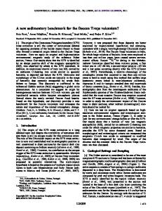
uWATER-PA While uWATER provides a general means for examination and analysis of spatial data, uWATER-PA targets a specific environmental issue: groundwater pumping. The governing equation used in uWATER-PA to compute drawdown (change in groundwater level) is the Theis equation (Theis 1935). This equation describes the drawdown caused by a single pumping well at different distances and after different durations of pumping in an idealized two-dimensional aquifer system. uWATER-PA is designed to address one of Goodchild’s (2010) questions by using a visualized map to show the results of drawdown analysis and this impact map can be easily disseminated to the general public. There are many numerical models available for simulating a three-dimensional groundwater flow system. However, these models are all computationally intensive and require sophisticated professional knowledge to develop, operate, and maintain. Assuming a uniform two-dimensional system reduces computation time significantly. It should be noted that due to this simplification, the results from uWATER-PA are intended as a preliminary assessment, not a replacement of sophisticated numerical models. The model assumes an idealized pattern of radial groundwater flow surrounding a single, constantly pumping well open to a confined aquifer (Figure 1, modified from Freeze and Cherry (1979)). The pumping rate of this well is Q [L3/T], the pumping duration is t [T], the transmissivity of the confined aquifer is T [L2/T], storativity is S [dimensionless], the original water level is h0 and the water level after t at distance r [L] is h(r,t). The Theis equation expresses the drawdown (s) at distance r after duration t as:
s ( r, t ) = h0 − h( r ,t ) =
Q 4π T
∫
∞
u
e−u du u
(1)
where
u=
r 2S 4Tt
(2)
The exponential integral in Equation (1) is known as the well function: W (u). Therefore, Equation (1) becomes:
s ( r, t ) = h0 − h( r ,t ) =
Q W ( u) 4π T
(3)
Groundwater textbooks typically provide a table of values of W(u) for various values of u. Srivastava and Guzman-Guzman (1998) developed an accurate approximation for the well function (Equations 4 and 5): © 2011 Blackwell Publishing Ltd Transactions in GIS, 2011, 15(s1)
114
Y-C E Yang and Y-F F Lin
Figure 1 Drawdown surrounding a single pumping well (modified from Freeze and Cherry 1979)
W ( u ) = ln
( Cu ) + 0.9563u − 0.1690u when u ≤ 1 1
W ( u) =
2
1 u + 0.3575 × when u ≥ 1 ue u u + 1.280
(4)
(5)
where C1 is Euler’s constant, i.e. C1 = 0.5615 The Pseudo code of uWATER-PA is given in Table 2. The transmissivity (T) and storativity (S) of the confined aquifer, which are critical controls on groundwater flow in the aquifer, are required to be imported. The locations of existing wells are also needed. The new well will be located by users directly on the map and the pumping rate (Q) and pumping duration (t) of the new well should also be keyed in by users. After the input procedure is completed, uWATER will use a loop to compute drawdown for each cell located within the distance of interest using the Theis equation (Table 2, Loop 1). Loop 2 in Table 2 will then assign a color to each cell with drawdown greater than zero based on the ratio between current cell drawdown and the maximum drawdown value. Finally, a third loop (Table 2, Loop 3) is used to identify the impact on existing wells.
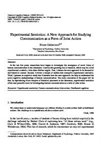
4 Example Calculation McHenry County, Illinois (Figure 2) is located approximately 50 km northwest of Chicago and is one of the fastest growing counties in the U.S. Midwest. Since the county’s © 2011 Blackwell Publishing Ltd Transactions in GIS, 2011, 15(s1)
Visualized Natural Resources Management
115
Table 2 The Pseudo code of uWATER-PA Import existing wells, transmissivity and storativity shapefile Record location of user defined new well Record pumping rate (Q) and duration (t) of new well ‘Loop 1 For every cell located within the distance of interest Compute distance (r) from current cell to the new well location Compute the average transmissivity (T) from current cell to the new well location Compute the average storativity (S) from current cell to the new well location Compute drawdown of current cell by Theis equation using Q, t, r, T and S. Next cell Record maximum drawdown value ‘Loop 2 For cells with drawdown greater than 0 Set color scheme for current cell based on the ratio between current cell drawdown and maximum drawdown value Output results to AGX display Next cell ‘Loop 3 For every existing well located within the distance of interest Record drawdown from cell where current well is located Set color scheme for current well based on drawdown Output results to AGX display Next well
water supplies are derived entirely from groundwater, groundwater resource management has become an issue of vital importance to the residents and economy of the county (McHenry County 2006). About 75% of this groundwater resource is derived from sand and gravel aquifers contained within the Quaternary glacial materials overlying bedrock. The remainder of the supply is withdrawn from shallow and deep bedrock aquifers underlying the glacial materials (Meyer 1998). Pumping from sand and gravel aquifers and the shallow bedrock aquifer has caused drawdown in several areas of McHenry County. This drawdown has been simulated using a 3D groundwater flow model developed by ISWS (Meyer et al. 2011) and saved in GIS format. If wetlands are hydrologically connected with these shallow aquifers, the water level in the wetlands may drop in response to pumping. In extreme cases wetlands may dry out, posing a significant threat to aquatic habitats. The McHenry County Conservation District has mapped the Advanced Identification wetlands (ADID wetlands) in GIS format within the county, many of which are groundwater dependent. Using the model drawdown results and the ADID wetlands data, uWATER can quickly identify wetlands that are threatened by groundwater development. The uWATER package can provide general information about the potential for drawdown to affect wetlands. The uWATER-PA package extends this capability by providing specific information about the potential drawdown impacts of a proposed well © 2011 Blackwell Publishing Ltd Transactions in GIS, 2011, 15(s1)
116
Y-C E Yang and Y-F F Lin
Figure 2 McHenry County, in Illinois with Advanced Identification (ADID) wetlands and existing wells pumping from both shallow and deep aquifers
on surrounding areas and wells. This capability provides a reference for the mandate of the Illinois Water Use Act of 1983, which requires that an impact assessment be completed for any proposed high-capacity well in Illinois. With its rapid growth and complete dependence on groundwater, McHenry County is an appropriate location for demonstration of uWATER-PA because its deep bedrock aquifers most closely meet the assumptions of the Theis equation.
5 Demonstration and Discussion of Results 5.1 uWATER Figure 3a shows the uWATER interface in AGX. Shapefiles showing ADID wetlands and groundwater modeling results (from Meyer et al. 2011) have been preloaded into AGX by the user, and a map depicting these features occupies the right portion of the interface. The uWATER interface uses a listbox to show all loaded shapefiles; the listbox is updated when the user clicks the Refresh button. Using the cursor to highlight the shapefile to be queried (in this case, the ADID wetland shapefile) and clicking the Select button, some basic information about the selected shapefile is displayed in the uWATER interface. There are more than 4,050 ADID wetlands in McHenry County as shown in Figure 3b. The user then clicks a radio button to select the spatial relationship for the query. In this example, the spatial relationship intersect has been selected (Figure 3b). From a dropdown list, the user then selects a second layer, which will be employed for query criteria. The groundwater modeling results shapefile is selected in this example. uWATER includes another dropdown list from which the user selects the attribute to employ in the query. The attribute table of the shapefile of groundwater modeling results includes, for © 2011 Blackwell Publishing Ltd Transactions in GIS, 2011, 15(s1)
Visualized Natural Resources Management
117
(a)
(b)
Figure 3 Demonstration of a complex query in uWATER: (a) ADID wetlands and groundwater modeling results; and (b) ADID wetlands intersecting with areas that have modeled drawdown between 5 to 150 feet
each model cell, attributes representing drawdown at the close of various selected years, pumping scenarios, and the name of the attribute (i.e. the column heading in the attribute table) indicating both year and pumping scenario. In this example, the attribute S_2050B (representing drawdown at the close of 2050 under a baseline pumping scenario) is selected. If the user wishes to specify a range of attribute values to employ in the query, he or she enters minimum and maximum values into windows provided in the uWATER interface. In this example, the user wishes to employ only those cells having drawdown © 2011 Blackwell Publishing Ltd Transactions in GIS, 2011, 15(s1)
118
Y-C E Yang and Y-F F Lin
(a)
(b)
(c)
Figure 4 The interface of uWATER-PA: (a) Data Input; (b) Impact Assessment; and (c) Impact System
values between 5 and 150 feet (Figure 3b). When the required information has been selected and entered, a summary of the query specifications is provided at the bottom of the uWATER interface. As shown in Figure 3b, the example query will identify the ADID wetlands intersecting groundwater model cells having modeled drawdown between 5 and 150 feet at the close of 2050 under a scenario of baseline pumping. The user then clicks the Identify Features button and the final results are shown in Figure 3b. In Figure 3b, the cells outlined in green denote areas having modeled drawdown between 5 and 150 feet. uWATER identifies in red the ADID wetlands intersecting the green-outlined cells; these wetlands are those facing the most significant threat due to groundwater drawdown in 2050. The general public can zoom in to their local areas and see if their nearby wetlands have been identified as threatened. Using uWATER to present the results may increase the chance for these wetlands to receive higher public attention. These query results might also be used by decision makers to target wetlands for monitoring.
5.2 uWATER-PA The uWATER-PA interface includes three major tabs (Figure 4). The Data Input tab (Figure 4a) is used to define units and to import the necessary data from AGX to uWATER-PA. The Impact Assessment tab (Figure 4b) is employed to specify the properties of the proposed new pumping well and the display settings for the computation and results. The Impact System (Figure 4c) tab shows the legend used to display the significance of the additional drawdown caused by the new pumping well. This legend is based on the ratio between the additional drawdown at one location to the maximum additional drawdown at the proposed new pumping well location. The user must first select the units to be employed in uWATER-PA (Figure 4a). These may be US customary units (miles for distance, ft2/day for transmissivity and gallons/day for pumping rate) or SI Metric units (kilometers for distance, m2/day for transmissivity and liters/day for pumping rate) for common management usage. The button Add a well © 2011 Blackwell Publishing Ltd Transactions in GIS, 2011, 15(s1)
Visualized Natural Resources Management
119
on the map using the cursor then allows the user to locate the new well anywhere on the map directly. This second step allows direct user-software interaction, making the decision process visual and intuitive. The user also must enter a range of interest (i.e. a radial distance from the well within which results will be displayed); alternatively, marking a check box will cause results to be displayed for the entire aquifer. The third step is to import transmissivity (T) and storativity (S) data from AGX into uWATER-PA. Shapefiles containing these data must be pre-loaded into AGX, and the user employs the cursor to select each shapefile, display its attributes, and select the attributes representing transmissivity and storativity. A similar procedure is required to import a shapefile representing existing wells from AGX into uWATER-PA. The Pumping Assessment tab (Figure 4b) allows the user to enter maximum and actual pumping rates and durations. Sliding bars provide convenient input for using different pumping rates and durations because these actual operational parameters of pumping well are often uncertain in advance or vary during operation. Optionally, the user can check a box to show the drawdown distribution as a color-coded impact map. Otherwise uWATER-PA will only show the impacted wells using a color-coded system. When the pumping rates and durations have been entered, the user clicks either Compute Impact with Maximal Pumping button or Compute Impact with Actual Pumping button for additional drawdown calculations. It should be noted that uWATER-PA does not require a predevelopment water level surface as input data, so the program output consists of additional drawdown caused by the proposed new pumping well. The absolute value of additional drawdown is given in the pop-up window of every cell. The maximum additional drawdown value caused by pumping from the proposed well is used for normalization of the result display. The impact in areas within the designated radius surrounding the proposed well is shown using color coding adapted from the Homeland Security Advisory System (Figure 4c). The degree of impact is calculated using the impact ratio, which is the ratio of the additional drawdown in a cell to the maximum additional drawdown (i.e. the drawdown in the cell containing the proposed well). Areas with extreme, high, elevated, perceptible and low impacts are shown in red, orange, yellow, blue and green, respectively. The same color scheme is used for the impacts on existing wells. Note that, regardless of the input data and grid size, the grid cell containing the proposed pumping well is always red because the impact ratio within the cell is always 1. As an example, we used uWATER-PA to evaluate the impacts of two hypothetical pumping wells at the same geographic location in rapidly-urbanizing southeastern McHenry County but finished in two different deep bedrock aquifers. These aquifers are the Ancell and Ironton-Galesville Units, the tops of which are about 400 to 600 feet and 1,000 to 1,200 feet beneath the land surface, respectively. Each proposed well is assumed to have a pumping rate (Q) of 200,000 gallons/day (the median value for wells open to these aquifers based on 2005 pumping data), and the radius of interest is set at 8 miles. For each of the two proposed wells, we examine the impact using the assumed pumping rate of 200,000 gallons/day and for two different pumping durations (t), 30 days and 365 days. Figure 5, which shows additional drawdown in the Ancell Unit, demonstrates that a longer pumping duration results in a greater impact radius. The maximum additional drawdown is 55 and 72 feet for pumping duration 30 days and 365 days, respectively. This information is accessed by clicking on the grid cell where maximum drawdown occurs (i.e. the cell containing the proposed well). In Figure 5a most of the area within © 2011 Blackwell Publishing Ltd Transactions in GIS, 2011, 15(s1)
120
Y-C E Yang and Y-F F Lin
Figure 5 uWATER-PA analysis results for a well pumping 200,000 gallon/day from the Ancell Unit aquifer for: (a) 30 days (maximum additional drawdown is about 55 feet); and (b) 365 days(maximum additional drawdown is about 72 feet)
the radius of interest is shaded green meaning that impacts to existing wells will be low. Perceptible level (blue) and higher impacts extend only 2 miles from the well location. Perceptible or higher impacts extend 5 miles from the well location when the pumping duration is prolonged to 365 days in Figure 5b. In this longer-duration scenario, one well closest to the proposed new well is in an area of high impacts. Figure 6 shows additional drawdown surrounding a well finished in the IrontonGalesville Unit at the same location and for the same scenarios of pumping rate and © 2011 Blackwell Publishing Ltd Transactions in GIS, 2011, 15(s1)
Visualized Natural Resources Management
121
Figure 6 uWATER-PA analysis results for a well pumping 200,000 gallon/day from the Ironton-Galesville Unit aquifer for: (a) 30 days (maximum additional drawdown is about 25 feet); and (b) 365 days (maximum additional drawdown is about 32 feet)
duration. As expected from the previous discussion, a longer pumping duration results in greater impacts. Maximum additional drawdown is 25 and 32 feet for pumping durations of 30 and 365 days, respectively. The major difference between Figures 5 and 6 is that for the same geographic location and scenario specifications, the impact range is larger for the Ironton-Galesville Unit than the Ancell Unit, but the maximum additional drawdown is higher in the Ancell Unit than the Ironton-Galesville unit. This is due to the difference in transmissivity between the aquifers. According to the data from the ISWS © 2011 Blackwell Publishing Ltd Transactions in GIS, 2011, 15(s1)
122
Y-C E Yang and Y-F F Lin
(Meyer et al. 2009), the value of storativity is the same for these two deep bedrock aquifers, but the Ironton-Galesville Unit has a higher transmissivity than the Ancell Unit. The higher transmissivity of the Ironton-Galesville is reflected by a wider impact range (larger radial impact) and lower maximum drawdown since this higher transmissivity permits groundwater to flow more readily in the horizontal direction. Horizontal flow is attenuated in aquifers with smaller transmissivities. The impact range in such aquifers is smaller, but the maximum drawdown is greater. We conclude that if a new well at this location is finished in the Ancell Unit, fewer existing wells will be affected, but the areas close to the new well will incur a greater impact. The outcome of pumping from the Ironton-Galesville at the proposed location will be the exact opposite. Since uWATER-PA’s result is additional drawdown instead of absolute drawdown, it provides the critical first step of impact assessment but not the complete process. In order to assess the actual impact of the new pumpage, the decision maker might need to explore additional information such as: (1) starting water levels; (2) pump intake elevations in nearby wells open to the source aquifer; and (3) the top and bottom elevations of the source aquifer. With such information, an individual could assess whether there is concern that the new well might cause nearby wells to suffer water-supply interruptions or cause the source aquifer to become partially or fully desaturated (Meyer 2011 pers. comm.). This comparison can be accomplished using the complex query function in uWATER, if the abovementioned additional information is available in GIS format.
6 Conclusions Providing useful and scientifically sound spatial information to planners and decision makers should be the ultimate goal of computer-based decision support systems (Blaschke 2004). This study has demonstrated the development of two decision support plug-in packages within ArcGIS Explorer Desktop: the ubiquitous WebGIS Analysis Toolkit for Extensive Resources (uWATER) and uWATER-Pumping Assessment (uWATER-PA) to respond two of Goodchild’s (2010) questions about the next steps for GIScience in the coming decade. The uWATER package reduces the contrast between public services tools and professional GIS software by coding the analysis function: spatial and attribute queries into a free GIS browser: ArcGIS Explorer Desktop. The intuitive interface of uWATER is general enough to be used in a wide range of natural and social management issues. The demonstration section used the wetlands identification, an ecological issue, but uWATER can also be used for economic analysis (e.g. identification of retail stores located in areas of high unemployment), social analysis (e.g. identification of liquor stores within a specified distance of a school) and agricultural analysis (e.g. identification of the major crop areas overlapping drought-sensitive areas). On the other hand, the uWATER-PA package is designed as a decision support toolkit for stakeholders and local governments for the specific purpose of assessing groundwater pumping impacts. If transmissivity and storativity data are available, uWATER-PA can quickly provide additional drawdown information for a proposed new well under the assumptions of the Theis equation prior to investing in a full-scale numerical groundwater flow model. uWATER-PA results show the additional drawdown caused by a proposed new well since neither current nor past pumping information is needed. The demonstration section illustrated the impact area and magnitude of a © 2011 Blackwell Publishing Ltd Transactions in GIS, 2011, 15(s1)
Visualized Natural Resources Management
123
proposed new well in the southeastern corner of McHenry County, a rapidly urbanizing area. uWATER-PA shows an approximate additional drawdown value for each cell and uses the maximum drawdown value (where the proposed pumping well is located) to compute the impact ratio and displays the result in a color map. Users can judge the influence of the potential well based on these results. uWATER-PA uses a visualized impact map to show the results of drawdown analysis and the outcomes can be easily disseminated to the general public. Further studies are recommended to compare the output from 3D numerical groundwater flow models with that of the preliminary evaluations possible using uWATER-PA. Since transmissivity and storativity data are neither nationally nor globally available, more hydrogeological studies to enlarge this database will certainly increase the benefit of uWATER-PA. In addition, we suggest trials of uWATER-PA in a range of hydrogeological settings to test the package’s robustness. Lastly, we are testing the use of uWATER-PA for assessing the effect of proposed new withdrawals on stream flow, and will make this available in future versions of uWATER-PA.
Acknowledgement Support for development of the uWATER and uWATER-PA packages was provided by McHenry County, Illinois, USA and the State of Illinois. The uWATER package (program, example files, and users’ manual) is free to download at http://www. isws.illinois.edu/gws/sware/. The uWATER-PA package is also available upon requests to the authors. The authors thank Scott C. Meyer, Philip M. Graff and Dr. Tom Holm for their assistance and suggestions. The authors also thank reviewers for their insightful comments.
References Blaschke T 2004 Participatory GIS for spatial decision support systems critically revisited. In Egenhofer M, Freksa C, and Miller H (eds.) Third International Conference on GIScience. Berlin, Springer-Verlag Lecture Notes in Computer Science Vol. 3234: 257–61 Butler D 2006 The web-wide world. Nature 436: 776–78 Craglia M, Goodchild M F, Annoni A, Camara G, Gould M, Kuhn W, Mark D, Masser I, Maguire D, Liang S, and Parsons E 2008 Next-Generation Digital Earth: A position paper from the Vespucci Initiative for the Advancement of Geographic Information Science. International Journal of Spatial Data Infrastructures Research 3: 146–67 Esri 2011 ArcGIS Explorer Desktop Website. WWW document, http://www.esri.com/software/ arcgis/explorer/index.html Freeze R A and Cherry J A 1979 Groundwater. Englewood Cliffs, NJ, Prentice-Hall Goodchild M F 2010 Twenty years of progress: GIScience in 2010. Journal of Spatial Information Science 21: 3–20 Goodchild M F, Egenhofer M J, Kemp K K, Mark D M, and Sheppard E 1999 Introduction to the Varenius project. International Journal of Geographical Information Science 13: 731–45 McHenry County 2006 County of McHenry, Illinois Groundwater Resources Management Plan. WWW document, http://www.co.mchenry.il.us/departments/waterresources/Pages/ ManagementPlan.aspx Meyer S C 1998 Ground-Water Studies for Environmental Planning, McHenry County, Illinois. Champaign, IL, Illinois State Water Survey © 2011 Blackwell Publishing Ltd Transactions in GIS, 2011, 15(s1)
124
Y-C E Yang and Y-F F Lin
Meyer S C, Roadcap G S, Lin Y-F, and Walker D D 2009 Kane County Water Resources Investigations: Simulation of Groundwater Flow in Kane County and Northeastern Illinois. Champaign, IL, Illinois State Water Survey Contract Report No. 2009–07 Meyer S C, Wehrmann H A, Knapp H V, Lin Y F, Glatfelter F E, Winstanley D, Angel J R, Thomason J F and Injerd D A 2011 Northeastern Illinois Water Supply Planning Investigations: Opportunities and Challenges of Meeting Water Demand in Northeastern Illinois. Champaign, IL, Illinois State Water Survey (draft) National Research Council 2010 Understanding the Changing Planet Strategic Directions for the Geographical Sciences. Washington, D.C., National Academies Press Srivastava R and Guzman-Guzman A 1998 Practical approximations of the well function. Ground Water 36: 844–48 Theis C V 1935 The relation between the lowering of the piezometric surface and the rate and duration of discharge of a well using groundwater storage. Transactions of the American Geophysical Union 2: 519–24 Yang Y C E and Lin Y F 2010 Making the results of analysis accessible: ArcGIS Explorer plug-in aids natural resources management. ArcUser 14(1): 22–25 (available at http://www.esri.com/ news/arcuser/0111/uwater.html)
© 2011 Blackwell Publishing Ltd Transactions in GIS, 2011, 15(s1)