A Spatially Explicit Model of Functional Connectivity for the Endangered Przewalski’s Gazelle (Procapra przewalskii) in a Patchy Landscape Chunlin Li1, Zhigang Jiang2*, Hongxia Fang2, Chunwang Li2 1 School of Resources and Environmental Engineering, Anhui University, Hefei, Anhui, China, 2 Key Laboratory of Animal Ecology and Conservation Biology, Institute of Zoology, Chinese Academy of Sciences, Beijing, China
Abstract Background: Habitat fragmentation, associated with human population expansion, impedes dispersal, reduces gene flow and aggravates inbreeding in species on the brink of extinction. Both scientific and conservation communities increasingly realize that maintaining and restoring landscape connectivity is of vital importance in biodiversity conservation. Prior to any conservation initiatives, it is helpful to present conservation practitioners with a spatially explicit model of functional connectivity for the target species or landscape. Methodology/Principal Findings: Using Przewalski’s gazelle (Procapra przewalskii) as a model of endangered ungulate species in highly fragmented landscape, we present a model providing spatially explicit information to inform the long-term preservation of well-connected metapopulations. We employed a Geographic Information System (GIS) and expert-literature method to create a habitat suitability map, to identify potential habitats and to delineate a functional connectivity network (least-cost movement corridors and paths) for the gazelle. Results indicated that there were limited suitable habitats for the gazelle, mainly found to the north and northwest of the Qinghai Lake where four of five potential habitat patches were identified. Fifteen pairs of least-cost corridors and paths were mapped connecting eleven extant populations and two neighboring potential patches. The least-cost paths ranged from 0.2 km to 26.8 km in length (averaging 12.4 km) and were all longer than corresponding Euclidean distances. Conclusions/Significance: The model outputs were validated and supported by the latest findings in landscape genetics of the species, and may provide impetus for connectivity conservation programs. Dispersal barriers were examined and appropriate mitigation strategies were suggested. This study provides conservation practitioners with thorough and visualized information to reserve the landscape connectivity for Przewalski’s gazelle. In a general sense, we proposed a heuristic framework for species with similar biological and ecological characteristics. Citation: Li C, Jiang Z, Fang H, Li C (2013) A Spatially Explicit Model of Functional Connectivity for the Endangered Przewalski’s Gazelle (Procapra przewalskii) in a Patchy Landscape. PLoS ONE 8(11): e80065. doi:10.1371/journal.pone.0080065 Editor: Judi Hewitt, University of Waikato (National Institute of Water and Atmospheric Research), New Zealand Received July 1, 2013; Accepted October 8, 2013; Published November 8, 2013 Copyright: © 2013 Li et al. This is an open-access article distributed under the terms of the Creative Commons Attribution License, which permits unrestricted use, distribution, and reproduction in any medium, provided the original author and source are credited. Funding: This study was supported by the Key Program of Knowledge Innovation Program of Chinese Academy of Sciences (KSCX2-EW-Z-4), the National Natural Sciences Foundation of China (No. 31070469, 31070348, 31372175), the Natural Sciences Foundation of Education Department of Anhui Province (No. 06061749), the Doctor Scientific Research Starting Foundation (No. 33190222), and young teacher foundation (No. 12333010296) of Anhui University of China. The funders had no role in study design, data collection and analysis, decision to publish, or preparation of the manuscript. Competing interests: The authors have declared that no competing interests exist. * E-mail:
[email protected]
Introduction
facilitates movement among resource patches”, people are putting increasing efforts in maintaining and restoring landscape connectivity. Numerous connectivity models have been put forward but there has been no consensus over their definitions and algorithms [7,8]. Despite disagreement over these connectivity models, researchers agree that involving species-specific perceptions of landscape determines, to a large extent, the success of a model in predicting potential connectivity between patches [7,9,10,11]. This consensus has motivated the concept of functional connectivity [7], which has rapidly expanded
Habitat fragmentation, associated with human population expansion and the following landscape modification, is of major concern to agencies of wildlife conservation [1,2]. Disconnected landscape impedes dispersal, reduces gene flow and aggravates inbreeding in endangered species [3]. Wellconnected landscape is considered necessary for long-term viability of extinction-prone metapopulation [2,4]. Since Merriam [5] firstly introduced the concept and Taylor et al. [6] defined it as “the degree to which the landscape impedes or
PLOS ONE | www.plosone.org
1
November 2013 | Volume 8 | Issue 11 | e80065
Functional Connectivity for Przewalski's Gazelle
Modeling overview
beyond stepping stones, migratory stopovers and habitat mosaics [2,10]. With the help of Graph Theory and Geographic Information System (GIS), a growing number of studies model least-cost functional connectivity between patches [12,13,14]. The functional model uses species-specific habitat preference, often based on expert opinion and literature [15,16], to depict the least-cost movement corridors or paths that provide better opportunities for successful dispersals. Advantages of this methodology include modest data requirements, a great benefit-to-effort ratio, visualized outputs and a convenient update process [7]. There exists, however, a common complaint about the expert-driven resistance estimates of landscape features, known as the “subjective translation problem” [17]. To improve the quality of and confidence in the least-cost algorithm, researchers suggest testing and refining the resultant map with empirical data, among others, results from landscape genetics are increasingly used [17,18,19]. Przewalski’s gazelle, endemic to the Qinghai-Tibetan Plateau, is one of the most endangered antelope species in the world [20] and listed as Endangered on the IUCN Red List [21] and as a Category I Key National Protected Wild Animal Species in China [22]. The population underwent significant decline from the 1950s onwards and is now constrained to several isolated habitat remnants around the Qinghai Lake (Figure 1) [22,23,24]. Since the 1990s, local populations of Przewalski’s gazelle have experienced different trends [23,25]. Gazelle populations in patches experiencing either rebounds in population size or declines in habitat suitability may disperse to search for potential habitats [25,26]. On the other hand, Yang et al. [27] found significant genetic differentiation in the species, which call for gazelle dispersals between patches. Although habitats of the gazelle are relatively flat moraine covered with steppe, sand dunes and meadows, the gazelle may not move along the shortest Euclidean distance due to habitat degradation. In this context, it is necessary to assess functional connectivity among patches, including extant distributed areas and new potential habitats. Thus far, except for a few inter-patch movements reported by local pastoralists and inferred by researchers [25,27,28], no studies have been conducted with regard to dispersal connectivity for Przewalski’s gazelle. Here, we present a spatially explicit model of habitat suitability and least-cost functional connectivity between the populations. We further evaluate and test the model using the latest evidence from landscape genetics of the gazelle [27]. This study presented thorough and visualized information for making conservation plans. In a general sense, we provided a heuristic framework to model landscape connectivity for species with similar biological characteristics and habitat patchiness to Przewalski’s gazelle.
We mapped habitat suitability and functional connectivity (least-cost corridors and paths) between habitat patches occupied by Przewalski’s gazelle based on Graph Theory, GIS and expert-literature method [10,18,29]. We first created a regional habitat suitability map and identified new potential habitat patches. Then we created a movement cost surface (permeability matrix) and modeled functional connectivity between neighboring pairwise habitat patches. We did not depict connectivity between patches over 25 km apart in that little or no gene flow of the gazelle had occurred beyond this threshold [27].
Study area Current distribution ranges of Przewalski’s gazelle are located around the Qinghai Lake (36°9’-37°56’N, 97°50’-101°6’E, Figure 1) [25]. The analytical window we used was large enough (58 610 km2) to include all the twelve extant distribution remnants, neighboring landscape and all potential looping corridors. The elevation of the analysis area ranges from 2 500 to 5 200 m. Dominant vegetation types include alpine meadow, alpine steppe, alpine shrub and psammophilous vegetation. The region has an inland plateau and typical semi-arid climate with dry, cold and long winters, a high level of solar radiation and a short frost-free period. Mean annual temperature is 0.5°C with the lowest record of -31°C and the annual precipitation is 350~420 mm.
Landscape features After reviewing previous literature and consulting gazelle experts, we selected ten landscape features that were supposed to influence how Przewalski’s gazelle perceive landscape: elevation, slope, normalized difference vegetation index (NDVI), human density and distances to rivers, highways, railways, farmlands, settlements and individual houses. Raster layers of elevation, slope, NDVI and human density and vectors of river, highway and railway were downloaded from national websites (Table 1). The MODIS 16-day NDVI was composited by imageries from the 12th to the 27th of July 2010, the height of the growing season for plants on the grassland around the Qinghai Lake. Vectors of farmlands, settlements and individual houses were obtained with the help of high resolution (2.5m) GoogleTM Earth imagery, which has been widely used in ecological and geographic studies [30,31]. Distances to the vectorial landscape features were calculated with the Spatial Analyst and saved in grid format. The ten raster layers were all projected in WGS 1984 UTM Zone 47N and rescaled to spatial resolution of both 250m and 30 m. All analyses were completed in ArcGIS 9.3 (ESRI 2008).
Methods Ethics Statement
Assigning suitability scores, movement cost scores and weights to landscape features
Our research protocols were approved by the Chinese Wildlife Management Authority. The study is an ecological model with no cruelty to animals and no review from the ethnic committee is required in China. All work was conducted under the Wildlife Protection Law of the People's Republic of China.
Before modeling habitat suitability and cost surface, cells in the raster layers were reclassified and each cell was assigned two integral scores (1-10) indicating habitat quality and movement resistance, respectively, for Przewalski’s gazelle. Due to the rarity of quantitative data, we employed the expert-
PLOS ONE | www.plosone.org
2
November 2013 | Volume 8 | Issue 11 | e80065
Functional Connectivity for Przewalski's Gazelle
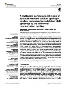
Figure 1. Habitat suitability map with extant and potential habitat patches of Przewalski’s gazelle. Przewalski’s gazelle are currently constrained in twelve isolated habitat remnants: Yuanzhe (YZ), Hudong (HD), Ketu (KT), Sand Island (SI), Ganzihe (GZ), Hargai (HG), Taliexuanguo (TL), Bird Island (BI), Kuairma (KM), Shengge (SG), Wayu (WY) and Ranquhu (RQ). The suitability scores range from one to ten, representing increasing habitat quality or movement resistance. Lakes in light blue and high mountains (> 4 000 m in elevation) in grey are avoided by the gazelle. doi: 10.1371/journal.pone.0080065.g001
Table 1. Variables involved in mapping habitat suitability and functional connectivity for the endangered Przewalski’s gazelle.
Data base
Resolution
Year of data
Source
Elevation
30 m
2009
International Scientific Data Service Platform (http://datamirror.csdb.cn/)
Slope
30 m
2009
NDVI
250 m
2010
Human density
1 km
2003
River
1:4000000
2009
Highway
1:4000000
2009
Railway
1:4000000
2009
Farmland
2.5 m
2008-2011
Settlement
2.5 m
2008-2011
Individual house
2.5 m
2008-2011
Data Sharing Infrastructure of Earth System Science (http://wdcrre.geodata.cn/Portal/index.jsp)
GPS locations collected during field surveys and GoogleTM Earth
doi: 10.1371/journal.pone.0080065.t001
PLOS ONE | www.plosone.org
3
November 2013 | Volume 8 | Issue 11 | e80065
Functional Connectivity for Przewalski's Gazelle
Table 2. Variables used in development of the habitat suitability model for Przewalski’s gazelle and expert-determined classification of landscape layers, corresponding suitability scores and weights.
Habitat suitability score*
Elevation (m)
1
< 3000
2 3 4
3000-3200
5
3700-3800
6
3600-3700
7
3500-3600
8
3400-3500
9
3300-3400
10
Slope (degree) 25-60
NDVI
Human density (/km2)
Distance to (m) river
highway 0-250
railway
farmland
0-250
0-250
45
>4000
3900-4000
0.1-0.2
40-45
3000-4000
3800-3900
0.2-0.3
35-40
2500-3000
250-500
0.3-0.4
30-35
0.4-0.5
25-30
2000-2500
500-1000
0.5-0.6
20-25
1500-2000
0.6-0.7
15-20
10-15
0.7-0.8
10-15
1000-1500
5-10
0.8-0.9
5-10
500-1000
1500-2000
3200-3300
0-5
0.9-1.0
0-5
0-500
>2000
>1000
>1500
N/A†
>4000
>60
Relative weights‡
0.0548
0.3891
0.1375
0.1813
0.0818
0.0964
0.0284
0.0307
20-25 15-20
250-500 250-500 500-750
1000-1500
500-1000 750-1000 1000-1500
* Suitability scores range from 1 to 10 representing low to high habitat quality. † An N/A value indicates that the gazelle never use the cells with those characteristics. ‡ Analytical Hierarchy Process (Saaty, 1987) was used to calculate the weights, which represent relative importance of variables to gazelle habitat selection. doi: 10.1371/journal.pone.0080065.t002
Table 3. Variables used in development of the functional connectivity model for Przewalski’s gazelle and expert-determined classification of landscape layers, corresponding movement cost and weights.
Movement cost*
Elevation (m)
10 9
3900-4000
8 7
railway
farmland
settlement
25-60
0-90
0-30
0-90
200-300
20-25
90-150 30-90
90-150
300-500
200-300
90-150
150-200
500-1000
300-500
150-200
200-300
1000-1500
3800-3900
individual house 30-90
150-200 10-15
90-150
3600-3800
4 3
Distance to (m) Highway
15-20
6 5
Slope (degree)
3400-3600
5-10
1
4000
>60
Relative weights‡
0.0322
0.3875
2
500-1000
150-300
1500-2000
1000-2000 >2000
>200
0.1715
0.0477
300-500
2000-2500
300-500
>500
>2500
>500