THIS IS THE AUTHOR’S VERSION OF THE WORK. THE DEFINITIVE VERSION OF RECORD WAS PUBLISHED IN, DOI 10.1145/1900179.1900215.
A Tracking Framework for Augmented Reality Tours on Cultural Heritage Sites Byung-Kuk Seo∗
Kangsoo Kim†
Jungsik Park‡
Jong-Il Park§
Department of Electronics and Computer Engineering Hanyang University, Seoul, Korea
Abstract Visual tracking is still challenging for augmented reality tours on cultural heritage sites because their tracking targets and environments are widely varying. Under such tracking environments, it is almost impossible for a single tracking method to be applied to the various environments successfully, even state-of-the-art tracking methods. This paper presents a tracking framework for augmented realty tours on cultural heritage sites. The tracking framework consists of different tracking flows and each tracking flow efficiently uses robust visual cues of the target scene. By analyzing the tracking environments, more practical tracking is supported at the real sites. The reliability of the tracking framework is verified through on-site demonstrations—Gyeongbokgung, which is the most symbolic cultural heritage site in Korea. CR Categories: H.5.1 [Information Systems]: Information Interface and Representation—Artificial, augmented, and virtual realities; I.4.8 [Image Processing and Computer Vision]: Scene Analysis—Tracking; I.4.9 [Image Processing and Computer Vision]: Application Keywords: camera tracking, augmented reality, multimedia tour guides
1
Introduction
Augmented reality (AR)-based on-site tour guides have provided intuitive and immersive experiences to tourists by superimposing virtual contents on real cultural heritage sites. There have been many studies and research projects for AR-based tour guides for cultural tourism [Noh et al. 2009]. For example, augmented realitybased cultural heritage on-site guide (Archeoguide) [Arc ] project presented new ways for accessing information at cultural heritage sites such as navigation, visualization of AR reconstruction of ancient life, and multimodal interaction. [Vlahakis et al. 2002] tested and evaluated Archeoguide at Greece’s Olympia archaeological site. Intelligent tourism and cultural information through ubiquitous services (iTacitus) [iTa ] is another good example of AR-based tour guides. iTacitus provides 3-D virtual models with multimedia contents such as video and audio on real sites. The prototype of iTacitus was implemented on Ultra Mobile PCs and recently, smartphones. It was demonstrated at Reggia Venaria Reale in Italy and Winchester Castle’s Great Hall in the UK [iTa ; Z¨oellner et al. 2009]. [Tenmoku et al. 2004] presented a navigation system, called ∗ e-mail:
[email protected] [email protected] ‡ e-mail:
[email protected] § e-mail:
[email protected] (corresponding author) † e-mail:
Nara Palace Site Navigator, and demonstrated on Nara palace site. Nara Palace Site Navigator provides tour guide information with AR contents according to the specifications of a user’s devices: wearable computer, personal digital assistant (PDA), and cellular phone. [Papagiannakis et al. 2005] developed an AR framework to revive life in ancient fresco paintings in ancient Pompeii and create narrative space. The framework superimposes 3-D virtual characters with body, speech, facial expression, and cloth simulation on the real environment. Tracking is a core technology for AR-based tour guides because it enables to correctly provide virtual contents to tourists at their different locations and viewpoints, and provides fully immersive experiences. Tracking technology has been widely studied in the field of computer science—particularly, computer vision and robot navigation. Most sensor devices, such as ultrasonic, global positioning system (GPS), inertial, and network sensors, highly support tracking. In particular, vision sensors such as cameras are commonly used for visual tracking. Visual tracking has been steadily proposed in the literatures. Marker-based camera tracking that detects visual markers laid on a target scene is a simple and robust approach (ARToolKit [Kato and Billinghurst 1999] is the most popular one). Because of visual interference of the markers, markerless tracking has been recently issued. The markerless camera tracking extracts natural information of the target scenes such as shape, texture, or geometric primitive. Among them, feature points such as corners or blobs have been widely used for visual cues of the target scenes with benefit of various detectors and descriptors [Tuytelaars and Mikolajczyk 2008]—typically, scale-invariant feature transform (SIFT) [Lowe 2004]. Camera tracking using feature points has mainly been exploited in 2-D planar-based tracking because a camera pose is easily estimated by homographies between feature points detected on planar scenes or objects. However, the use of feature points is much limited to robustly track 3-D objects with complex geometry or without texture. As one of solutions, model-based tracking has been well-suited for 3-D object tracking. In the model-based tracking, features of 3-D object models such as edges [Drummond and Cipolla 2002] or contours [Rosten and Drummond 2003] have been used for camera tracking. Despite visual tracking has provided good solutions for AR applications, it is still challenging for accurately augmenting virtual contents on the real sites (as also mentioned in [Zoellner et al. 2008]). In cultural heritage sites, tracking targets and environments are widely varying so that it is almost impossible for a single tracking method to be applied to the various environments successfully, even state-of-the-art tracking methods. This paper presents a tracking framework for AR tours on cultural heritage sites. The tracking framework consists of different tracking flows and each tracking flow efficiently uses robust visual cues of the target scene. By analyzing the tracking environments, more practical tracking are supported at the real sites. The reliability of the tracking framework is verified through on-site demonstrations—Gyeongbokgung, which is the most symbolic cultural heritage site in Korea. This paper presents results from an on-going project—development of experience tour technology based on mobile mixed reality, shortly mobile augmented reality tour (MART). The MART project is currently developing new tour guide services on mobile phones
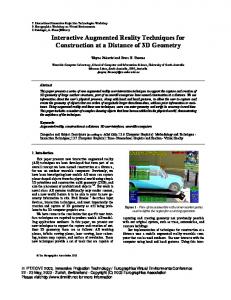
GPS Digital compass Inertial sensor (accelerometer, gyroscope)
TF1
Pose
Pose estimation
Location Orientation Velocity
ROI TF2
Camera
Visual cue detection
Image
ROI
TF3
Visual cue
Visual cue matching
Initial pose
Pose estimation
Pose
TF4
Scene data Matching data
Other sensors (illumination sensor, etc)
DB: contextual information (location profile, (location, profile etc)
Sensor data
ROI ROI
DB: scene information j model,, etc)) -Scene model ((feature model,, 3-D object -Reference images or patches, or their sets with a certain family of transformations
Figure 1: Tracking framework. (TF1: sensor-based tracking flow, TF2, TF3: vision-based tracking flow, TF4: hybrid tracking flow).
using AR. This paper mainly focuses on visual tracking developed by our research group in the MART project and shows our results with experiences.
2
Tracking Framework
The tracking framework of our AR-based on-site tour system is shown in Figure 1. It consists of sensing devices to obtain scene information and processing modules to estimate poses of the system. The processing modules also have three tracking flows: sensorbased tracking, vision-based tracking, and hybrid tracking. Each flow is adaptively performed according to tracking environments on real sites. Sensor-based tracking (TF1) estimates poses of the tour system by measuring its location, orientation, and velocity from sensors such as GPS, digital compass, and inertial sensors. GPS is a popular commercialized sensor and it commonly provides location-based service (LBS). In particular, most smartphones recently have GPS so that many mobile AR applications, such as Layar [Lay ] and Wikitude [Wik ], offer LBS using GPS. Vision-based tracking (TF2, TF3) estimates poses from images of a target scene captured by a camera. In vision-based tracking, visual cues such as edge, corner, or feature point are detected in the captured images. Pose estimation is performed along tracking flows which are adaptively selected according to dominant features of the target scene. In case of tracking flow 2 (TF2), the poses are estimated by directly using the detected visual cues when characteristic of the target scene is known, e.g., geometric primitives of the target scene such as line segments or rectangles are dominant in the target scene. In case of tracking flow 3 (TF3), reference information of the target scene is predefined as a database. The poses are estimated by matching the detected visual cues to predefined ones of the database. The predefined scene information can be reference images or patches, or their sets with a certain family of transformations such as rotation, scale, and affine transformation. It also can
be scene models such as feature model or object model. To match the detected visual cues to ones of the database, each visual cue in both images or patches is converted to descriptors and the correspondences are found by comparing their similarity. Then, the poses are estimated by computing transformations between correspondences, e.g., homographies between planar features. Reference image or patch sets with a certain family of transformations also can be efficiently used because database constructing is usually performed in offline once and the matching process is simple. When a target scene has 3-D objects with complex geometry or without texture, scene models that includes 3-D information of the target scene can be used for tracking. The scene models can be a feature model or an object model. The feature model is built by reconstructing 3-D coordinates of feature points of the target scene. For reconstruction, the structure-from-motion (SfM) method is commonly used. The poses are estimated using known 2D-3D correspondences of the feature points. The object model is obtained by modeling 3-D objects of the target scene. The poses are estimated by matching the detected visual cues of the 3-D object such as edges or contours to ones of the projected object model. Hybrid tracking (TF4) uses all measurements obtained by sensorbased tracking with vision-based tracking. In particular, the sensorbased tracking can provide preknowledge of a target scene for efficient vision-based tracking, e.g., region of interest (ROI) and an initial pose of the system. Contextual information of the target scene also offers helpful information to estimate the poses of the system such as locations or situations of the target scene.
3
Practical Tracking on Real Sites
The MART project is aiming at providing mobile AR-based tour services on cultural heritage sites. As the first trial test zone, Gyeongbokgung area including the National Palace Museum of Korea was chosen. Gyeongbokgung is a royal palace located in Seoul, Korea and it is the most symbolic cultural heritage site in Korea.
Gyeongbokgung has already provided several tour guide services such as booklets, local guides, and portable audio devices. However, these services have mainly been used to offer and explain historical information of cultural heritage sites. Using the AR-based tour system which is developing by the MART project, intuitive and realistic experiences are provided to tourists by augmenting 3D virtual contents, which reproduce past life on real sites. Gyeongbokgung has many palace and court buildings. They have mostly similar external appearances characterized by Korean traditional architecture. However, tracking targets and environments are varying according to their usage and exhibitions. Moreover, exhibition zones in cultural heritage sites are predefined and partially restricted to access because of preservation. This presents practical solutions under such tracking environments and workingin-progress results are shown in detail.
3.1
(a)
Tracking Environments
Tracking environments of main spots of a popular tour route in Gyeongbokgung—Geunjeongjeon and its courtyard, Sajeongjeon, Gangnyeongjeon, and Gyotaejeon were analyzed (see Figure 2). Geunjeongjeon courtyard: A great courtyard is extended in front of Geunjeongjeon. In the courtyard, visual cues for tracking are difficult to detect because it is covered with hewn stones and has several stone markers. Many tiles of the entrance gate’s roof and colonnade have repetitive patterns so that feature points detected from them are not invariant. Corners detected from the entrance gate and background buildings can be used for visual tracking in the courtyard (see Figure 2(c)). However, the courtyard is generally hard to visually track the target scene because it is outdoor environment; thus lighting condition often changes, particularly according to time of day, season, and weather. In addition, the courtyard is mostly occluded by many tourists who stay or pass by, as shown in Figure 2(b). Geunjeongjeon and Sajeongjeon: Geunjeongjeon and Sajeongjeon were used for purposes such as king’s affairs; thus their appearances are similar each other—the royal throne is centered and surrounded by four pillars, and its background has a picture (see Figure 2(d,e)). Geunjeongjeon has sufficient features, but they are complex and repetitive textures. On the other hand, Sajeongjeon has a hanging picture on the upper side of the royal throne that can be used as a reference for visual tracking. In both sites, 3-D objects such as the royal throne and four pillars can be used as object models, but their edges are not easily extracted from cluttered background and the modeling is hard and delicate. There is little lighting change because both sites are indoor environment and one or several doors are opened for tourists. Gangnyeongjeon and Gyotaejeon: Gangnyeongjeon and Gyotaejeon offer a glimpse into everyday life in the royal household— Gangnyeongjeon was served as the king’s living quarter and Gyotaejeon was served as the queen’s main residence. In particular, rooms of both sites are opened for tourists so that they can enter the sites and see inside rooms as shown in Figure 2(f,g). A few feature points can be detected on holding screens in the rooms, but they are not sufficient. As inside exhibitions such as cushion and royal tables (Gangnyeongjeon) and cushions, reading table, and red lacquered mirror stand (Gyotaejeon) have simple shape, they can be used for object models if their edges can be apparently detected. Doorframes have simple geometric primitives such as rectangle and they can be used as good invariant features for visual tracking. Lighting change is very little. In addition, locations of inside exhibitions are not absolutely fixed. It means that 3-D information of scene models built from the target scene can be frequently changed.
(b)
(c)
(d)
(e)
(f)
(g)
Figure 2: Tracking environments. (a) tour map of Gyeongbokgung (available at http://www.royalpalace.go.kr/) (red rectangle indicates each regions), (b,c) Geunjeongjeon courtyard, (d) Geunjeongjeon, (e) Sajeongjeon, (f) Gangnyeongjeon, (g) Gyotaejeon.
3.2
Tracking Using Local Features
As shown above, tracking environments of Gyeongbokgung are not easy to detect and match robust feature points. However, many palace and court buildings consist of geometric primitives such as line segments or rectangles, which are the bases of most man-made structures; thus, we efficiently track robust local features by using this knowledge of target scenes. For example, in Sajeongjeon, the hanging picture on the upper side of the royal throne has rectangle shape with texture. In Gangnyeongjeon and Gyotaejeon, the doorframes of the main rooms consist of rectangle structure. The workflow of rectangle tracking is as follows (also presented in our previous work [Kim et al. 2009]). First, edges of a target scene are detected using the Canny operator. Contours which can be candidates for a rectangle in the edges are found. Note that the edges are linked to minimize their discontinuity using dilation. Then, rectangles are extracted by searching the contours with some
(a)
(b)
(c)
(d)
(e)
(f)
(g)
(h)
Figure 3: Demonstrations on Sajeongjeon, Gangnyeongjeon, Gyotaejeon, and Geunjeongjeon courtyard. (a–c) rectangle detection (yellow: rectangle, green: diagonal line of rectangle), (d–f) 3-D virtual character augmentation (king, king with subjects, queen), (g) feature point detection, (h) 3-D virtual character augmentation (royal ritual reproduction), ((d,e,f,h) are snapshot images of animated contents.
constraints: convexity, four corners, and the area of the rectangle. When this fails (the rectangle is not extracted), the four corners on the current image can be approximated from the previous ones if the camera’s motion is not fast; thus, we find the correspondences of the corners obtained from the previous image using optical flow analysis [Bouguet 2000]. Finally, poses are estimated using planarbased pose estimation [Schweighofer and Pinz 2006] with the four corners of the extracted rectangle. Here, we assume that the four corners are coplanar. With the estimated poses, 3-D virtual characters are correctly augmented on the target scene as shown in Figure 3—demonstrations on Sajeongjeon, Gangnyeongjeon, and Gyotaejeon. In the demonstrations, the prototype was implemented on a laptop (LG X-NOTE C1, Intel Core2 1.20 GHz) with a USB camera (MS LifeCam NX-6000, resolution 640 by 480, 15 fps). Geunjeongjeon courtyard is very hard for visual tracking because it is outdoor environment and local features cannot be detected from the floor of the courtyard which is covered with stones. In our approach, we use feature points detected from the entrance gate’s roof and its background buildings. As a preprocess, patches centered on feature points are predefined and they are matched to ones detected from a current image. Then, the camera motion is estimated using optical flow analysis [Bouguet 2000]. Figure 4 shows a demonstration on Geunjeongjeon courtyard using the same hardware devices mentioned above. Note that the demonstration was performed when
tourists did not occlude. The AR service zone was defined in the service scenario because the target scene covers very large area in the courtyard; thus, it suffices to acquire only camera orientation for plausible AR rendering.
3.3
Tracking Using Object Models
Visual tracking using feature points is well-established for 2-D planar-based tracking. However, it is much limited to robustly track 3-D objects with complex geometry or without texture. There are many exhibitions in the Gyeongbokgung and Angbuilgu which is a National Treasure No.845 is a good example. Angbuilgu is a kind of sundial that was constructed in the shape of a hemisphere in order to express the shape of the sky. The scale model is located in front of Sajeongjeon as shown in Figure 4. To robustly track a 3-D exhibition, we developed model-based tracking that estimates camera poses using its object model and feature model. Figure 5 is the workflow of model-based tracking. Note that it is a extended version of our tracking method published in [Park et al. 2010] so that this paper does not handle its more details including equations and briefly summarizes. In offline process, 3-D objects and texture information of a target scene are modelled. With the scene models (object model and fea-
target object model
Input Images
Edges detection (Canny)
4
Conclusion
In this paper, we presented a tracking framework for augmented reality-based on-site tours developed from our on-going project. At main sites in Gyeongbokgung, their tracking environments were analyzed and more practical visual tracking were successfully applied to the real sites. Moreover, the promising results were shown through on-site demonstrations. Currently, we are continuously testing our visual tracking methods and improving their performance. Furthermore, it is implementing on the smartphone for mobile augmented reality tour services.
Acknowledgements
Optical analysis
Initial or previous camera pose E(k)
SURF
Edge sampling Visibility test Edge matching
Update loop U
ture model), edges and feature points are detected in the scene image and matched to correspondences of each model. The edges are detected using the Canny operator. For finding their correspondences, the object model is projected and their edges are regularly sampled. Then, the closest edges to their normal direction are defined as the correspondences. The feature points are detected and matched using speeded up robust features (SURF) [Bay et al. 2008]. For computational efficiency, however, the feature points are tracked using optical flow analysis [Bouguet 2000] and SURF is performed for initialization or recovery of a pose. To update a camera pose, the camera motion is defined as the displacement of both visual cues and computed by minimizing their reprojection errors. Moreover, both measurements are weighted by their confidences on the target scene. Tracking results using our model-based tracking are shown in Figure 6. In the experiment, a pottery was modelled as an object model (wireframe model shown in Figure 6(a)). Given the object model with the feature model, the poses were accurately estimated in real-time. Figure 7 shows a demonstration using an on-site exhibition—scale model of Angbuilgu. The upper part with ring shape of the exhibition was modeled as a object model (wireframe model shown in Figure 7). Particularly, in the demonstration, the model-based tracking robustly tracked the exhibition even though it was partially occluded by a tourist as shown in Figure 7(e–h).
Feature points Detection & matching
Iniitialization or recovery
Figure 4: On-site exhibition (scale model of Angbuilgu located in front of Sajeongjeon).
Feature model
Calculate confidence of edges and feature points Error function Err = f(errc, errf ) Compute ∆E
Current camera pose Ek+1 = Ek ·∆E
Figure 5: Workflow of model-based tracking.
B OUGUET, J.-Y., 2000. Pyramidal implementation of the Lucas Kanade feature tracker description of the algorithm. http://robots.stanford.edu/cs223b04/ algo_tracking.pdf. D RUMMOND , T., AND C IPOLLA , R. 2002. Real-time visual tracking of complex structures. IEEE Transactions on Pattern Analysis and Machine Intelligence 24, 7, 932–946. iTacitus. http://www.itacitus.org/. K ATO , H., AND B ILLINGHURST, M. 1999. Marker tracking and HMD calibration for a video-based augmented reality conferencing system. In International Workshop on Augmented Reality, 85–94. K IM , K., S EO , B.-K., H AN , J.-H., AND PARK , J.-I. 2009. Augmented reality tour system for immersive experience of cultural heritage. In International Conference on Virtual Reality Continuum and its Applications in Industry, 323–324.
This research was supported by Ministry of Culture, Sports and Tourism (MCST) and Korea Creative Content Agency (KOCCA) in the Culture Technology (CT) Research & Development Program 2009 (2nd year).
Layar. http://www.layar.com/.
References Archeoguide. http://archeoguide.intranet.gr/.
L OWE , D. 2004. Distinctive image feature from scale-invariant keypoints. International Journal of Computer Vision 60, 2, 91– 110.
BAY, H., E SS , A., T UYTELAARS , T., AND G OOL , L. V. 2008. SURF: Speeded up robust features. Computer Vision and Image Understanding 110, 3, 346–359.
M ATAS , J., C HUM , O., U RBAN , M., AND PAJDLA , T. 2002. Robust wide baseline stereo from maximally stable extremal regions. In British Machine Vision Conference, 384–393.
L EPETIT, V., AND F UA , P. 2006. Keypoint recognition using randomized trees. IEEE Transactions on Pattern Analysis and Machine Intelligence 28, 9, 1465–1479.
(a)
(b)
(c)
(d)
Figure 6: Model-based tracking using a 3-D object (pottery). (a) wireframe model (yellow) overlaid on the real model, (b–c) 3-D virtual character augmentation (some parts of video sequences).
(a)
(b)
(c)
(d)
(e)
(f)
(g)
(h)
Figure 7: Demonstration using an on-site exhibition (scale model of Angbuilgu). Tracking results in (a–d) normal case and (e–h) occlusion case (some parts of video sequences).
N OH , Z., S UNAR , M. S., AND PAN , Z. 2009. A review on augmented reality for virtual heritage system. Lecture Note on Computer Science 5670, 50–61.
Device-independent human navigation using a networked shared database. In International Conference on Virtual Systems and Multimedia, 1234–1242.
PAPAGIANNAKIS , G., S CHERTENLEIB , S., O’K ENNEDY, B., A REVALO -P OIZAT, M., M AGNENAT-T HALMANN , N., S TOD DART, A., AND T HALMANN , D. 2005. Mixing virtual and real scenes in the site of ancient Pompeii. Computer Animation and Virtual Worlds 16, 1, 11–24.
T UYTELAARS , T., AND M IKOLAJCZYK , K. 2008. Local invariant feature detectors: A survey. Foundations and Trends in Computer Graphics and Vision 3, 3, 177–280.
PARK , H., O H , J., S EO , B.-K., AND PARK , J.-I. 2010. Automatic confidence adjustment of visual cues in model-based camera tracking. Computer Animation and Virtual Worlds 21, 2, 69– 79. ROSTEN , E., AND D RUMMOND , T. 2003. Rapid rendering of apparent contours of implicit surfaces for realtime tracking. In British Machine Vision Conference, 719–728. S CHWEIGHOFER , G., AND P INZ , A. 2006. Robust pose estimation from a planar target. IEEE Transactions on Pattern Analysis and Machine Intelligence 28, 12, 2024–2030. T ENMOKU , R., NAKAZATO , Y., A NABUKI , A., K ANBARA , M., AND YOKOYA , N. 2004. Nara palace site navigator:
V LAHAKIS , V., I OANNIDIS , N., K ARIGIANNIS , J., T SOTROS , M., G OUNARIS , M., S TRICKER , D., G LEUE , T., DAEHNE , P., AND A LMEIDA , L. 2002. Archeoguide: An augmented reality guide for archaeological sites. IEEE Computer Graphics and Applications 22, 5, 52–60. Wikitude. http://www.wikitude.org/. Z OELLNER , M., PAGANI , A., PASTARMOV, Y., W UEST, H., AND S TRICKER , D. 2008. Reality filtering: A visual time machine in augmented reality. In International Symposium on Virtual Reality, Archaeology and Cultural Heritage, 71–77. ¨ Z OELLNER , M., K EIL , J., D REVENSEK , T., AND W UEST, H. 2009. Cultural heritage layers: Integrating historic media in augmented reality. In International Conference on Virtual Systems and Multimedia, 193–196.