7.2
NOWCOAST: A WEB MAPPING PORTAL TO REAL-TIME OBSERVATIONS AND NOAA FORECASTS FOR THE COASTAL U.S. John G.W. Kelley, E. Matthew Kennedy, Micah Wengren, and Meredith Westington Coast Survey Development Laboratory, National Ocean Service, Silver Spring, MD National Ocean Service, Silver Spring, MD
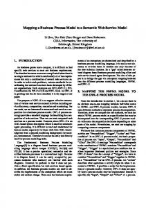
1. INTRODUCTION The National Ocean Service's (NOS’) Coast Survey Development Laboratory has developed and implemented a Web mapping portal called nowCOAST to provide the marine community with the capability to view all on-line, real-time observations as well as NOS and National Weather Service (NWS) forecasts for major U. S. estuaries and seaports, adjacent coastal ocean regions, and the Great Lakes. The portal provides spatially-referenced links to real-time information from meteorological, oceanographic, and river observing networks operated by federal and state agencies and educational institutions, to forecast point guidance from NOS and NWS forecast models, and NWS weather and marine forecasts. nowCOAST is being enhanced to display gridded analysis and forecast fields from NOS and NWS that are of interest to marine users. Thus, it provides a ‘one-stop shopping’ Web site to real-time information from a variety of sources in the coastal states. This information is needed for commercial shipping and recreational activities, as well as for coastal monitoring, prediction, and hazard assessment and response. The purpose of this paper is to describe the Web portal and discuss plans for future versions. 2. OVERVIEW OF THE PORTAL nowCOAST was constructed using ESRI’s commercial off-the-shelf Geographic Information Systems (GIS) software Arc Internet Map Server (ArcIMS) Version 4.x. The map server along with the Apache 2.0.4x Web server and Jakarta Tomcat 4.0.x servlet engine runs on a Dell Precision 530 2.2Ghz Intel Xeon computer. The portal user interface (Fig. 1) was designed to serve both GIS and non-GIS experienced users. Customizations were made in DHTML and JavaScript for the purpose of meeting the needs of these two distinct user groups. The non-GIS user group focuses on rapidly finding the data and/or forecast products they are interested in. Since this group is presumably unfamiliar with standard GIS software tools and functions, a Web interface was created that quickly guides the user to the information he or she chooses.
Corresponding author address: Dr. John G. W. Kelley/NOAA/National Ocean Service, Coast Survey Development Laboratory, 1315 East-West Highway, N/CS13, Silver Spring, MD 20910-3282; e-mail:
[email protected].
Fig. 1: nowCOAST user interface. The interface consists of three 'pull-down' menus that were created for the user to select: 1) location (i.e. a specific estuary, seaport, coastal region, or Great Lake), 2) type of observation or forecast (i.e. weather, ocean, river, or water quality observations, model forecasts, or surface forecasts), and 3) variable (i.e. water level, air temperature, wave height, etc.). After selecting any or all of the 3 options, the user chooses “Go” to create a map for their specified information and location. To further inspect the data or forecast product, GIS and non-GIS users may choose to utilize the out-of-the-box GIS functionality of the ArcIMS Web portal. Common GIS tools include Search, Zoom, Pan, Select by Rectangle, Identify, Query, and Print. These tools can be used to enrich the user's experience with the portal. Geographic information, including URL addresses of the Web sites providing real-time observations and NOAA forecast products, was collected manually with a series of Perl scripts and inserted into a Microsoft Access database. Quality control, verification, and conversion scripts were also written in Perl and connected to the Access database via the Open Database Connectivity Perl Database Interface (DBI) module. DBase files (DBF) IV tables were exported from Access and imported into ESRI's ArcView 3.x. The DBF tables were then converted to shapefiles and added as content to the ArcIMS MapService. The Federal Geographic Data Committee (FGDC)compliant metadata for nowCOAST is available at the National Spatial Data Infrastructure Clearinghouse at http://130.11.52.184/servlet/FGDCServlet and also at
http://nauticalcharts.noaa.gov. The metadata refers to each online source of information included in the nowCOAST Web portal. 3. CONTENT 3.1 Observations Presently, the portal provides spatially-referenced links to the following weather and ocean observing networks: NOS’ Physical Oceanographic Real-Time System (PORTS) and National Water Level Observation Network stations, National Data Buoy Center’s (NDBC’s) fixed buoys and Coastal-Marine Automated Network (C-MAN) stations, NWS/Federal Aviation Administration(FAA)/ Department of Defense’s (DOD’s) Automated Surface Observing System (ASOS), FAA’s Automated Weather Observing System (AWOS), and surface stations of the Ground-Based GPS Meteorology Demonstration Network as well as non-federal government stations. These nonfederal networks include the Chesapeake Bay Observing System, Coastal Observing and Prediction System in Florida, Texas Automated Buoy System, and the Gulf of Maine Ocean Observing System. An example of a nowCOAST map providing Web links to real-time wind observing stations is given in Fig. 2.
Fig. 3: Example of map depicting location of river observing gages and 100 km coverage area of NWS Doppler weather radars in the Galveston Bay region. For water quality observations, the portal provides links to Environmental Protection Agency (EPA) Environmental Monitoring for Public Access Community Tracking (EMPACT) stations. An example of a map displaying clickable links to Web sites providing displays of real-time water quality observations is given in Fig. 4.
Fig. 2: Example of map depicting surface wind observing sites in the northern Chesapeake Bay region. Also depicted are names of bays and major cities and highways.
Fig. 4: Example of map depicting location of real-time water quality observing in eastern Long Island Sound. Also depicted are ferry routes.
In addition, the portal provides links to NWS/DOD radiosondes, boundary layer wind profilers operated by NOAA, state agencies or universities, and NWS Doppler weather radar sites. For real-time river observations, the portal links to the United States Geological Survey’s (USGS’) river gages and also to Integrated Flood Observing and Warning System (IFLOWS) stations. An example of a map depicting both river observing stations and 100km coverage from NWS Doppler weather radars is provided in Fig. 3.
3.2 Text Forecasts The Web portal provides links to NOAA’s weather and oceanographic model point forecast guidance from NWS’ Model Output Statistics (MOS), Extra-Tropical Storm-Surge Model, NOAA WaveWatch III Model, and NOS’ estuarine forecast models for the Chesapeake Bay, Port of New York/New Jersey, and Galveston Bay. An example of a nowCOAST map depicting county and marine forecast zones and locations where forecast model point guidance is available is given in Fig. 5.
In addition, the Web portal links to county weather and coastal marine zone forecasts prepared by NWS’ Weather Forecast Offices and also to the high seas forecasts produced by NWS’ Ocean and Tropical Prediction Centers.
forecast with the additional time pulldown menu is shown in Fig. 6.
Fig. 5. Example of map depicting NOS and NWS forecast model point forecast guidance along with county weather forecast and marine zones for the Port of New York and New Jersey.
Fig. 6. Example of map depicting a 24-h maximum air temperature forecasts from the NDFD for the northeastern U.S. Forecast is valid for 21 May 2003.
3.3 Gridded Forecasts
4. PLANS
nowCOAST is being enhanced to display selected gridded meteorological and oceanographic fields from NWS’ National Digital Forecast Database (NDFD) of interest to marine users. NDFD is intended to replace current forecasting techniques and dissemination methods. It will contain 5 km gridded fields of the following variables: maximum temperature, minimum temperature, hourly temperature, probability of precipitation, sky cover, dew point, heat indices, wind direction, wind speed, weather, and wave height. Temporal resolution of the variables is as follows: 24 hours (max-temp, min-temp), 12 hours (probability of precipitation), 3 hours out to 72 hours and 6 hours out to 168 hours (sky cover, temperature, dew point, heat indices, wind direction, wind speed). The target date for implementation of the NDFD is 30 September 2003 for the conterminous states and 31 December 2003 for Alaska, Hawaii and Guam. Individual gridded fields of particular variables will be released by NWS as experimental products successively until the completion date is reached.
The nowCOAST Web portal is available at http://nauticalcharts.noaa.gov/csdl/op/nowcoast.htm. At the present time, the Web portal is maintained during weekdays, however it will soon become a fully operational product and continuously maintained. Future versions of nowCOAST will display gridded fields of hourly temperature, dew point, weather, and heat indices in late 2003 after a new beta version of NDFD is released in the summer. In addition, there is the potential for nowCOAST to display selected surface meteorological and oceanographic fields from NOS and NWS/National Centers for Environmental Prediction (NCEP) numerical prediction models.
Initially, nowCOAST will display NDFD’s maximum and minimum temperature gridded fields for the conterminous states. For each variable, nowCOAST will display each temporal gridded field of forecast values (zero hours, 24 hours, 48 hours, etc.), and will retain past gridded fields for display up to five to seven days. Display of the NDFD gridded fields will be controlled by the user via the pulldown menus on the nowCOAST viewer, including a new pulldown menu for temporal forecast projection. An example of a gridded 24-hr maximum temperature
5. ACKNOWLEDGMENTS The project is funded by a grant from NOAA/National Environmental Satellite, Data, and Informational Service’s Environmental Services Data and Information Management (ESDIM) Program. The portal seeks to support one of ESDIM Program’s objectives, which is to “improve access to NOAA environmental data and information for scientists and decision makers.”