P. Stopher, K. Button, K. Haynes and D. Hensher (eds.) Handbook of Transport 5: Transport Geography and Spatial Systems, Pergamon/Elsevier Science, in press.
Activities in Space and Time Harvey J. Miller Department of Geography University of Utah 260 S. Central Campus Dr. Room 270 Salt Lake City, Utah 84112-9155 USA
[email protected]
Introduction Human lives consist of activities such as working, raising families, socializing, shopping and recreation. These activities require time and space, and are often only available at particular locations for limited durations. People differ with respect to the location and timing of key activities in their lives (e.g., home, work) as well as available time and transportation and communication resources to conduct these activities. Cities, transportation and communications systems exist to alter space and time. A city compresses many human lives into a relatively small space to reduce time and other resources required for humans to interact and conduct shared activities. Transportation systems reduce the amount of time required for movement across space. Communication technologies eliminate space for some types of interaction. In turn, cities, transportation and telecommunications systems shape human activities by altering the relationships between space and time in human interaction and activity participation. The observations listed in the preceding paragraphs seem uncontroversial, perhaps even trite. Yet many transportation and urban models ignore the basic spatial and temporal conditions of human activities. Transportation and communication have critical roles in fitting people and activities together in space and time to create functioning socio-economic systems. Understanding how transportation and communication technologies facilitate and constrain the spatio-temporal web of human interaction is crucial for designing efficient, livable and sustainable cities and economies (Hägerstrand 1970). This chapter discusses theories and methods for analyzing the interrelationship of human activities in space and time. This chapter focuses on time geography: an elegant and powerful framework developed by Torsten Hägerstrand and his colleagues at Lund University in Sweden during the 1950’s and 1960’s. The relevance of time geography for analyzing real world transportation and communication systems has improved tremendously in recent years with the rise of geographic
information technologies such as geographic information systems (GIS) and the global positioning system. At the same time, information technologies such as the Internet and mobile telephony have drastically altered the relationships between geo-space and time in the real world, creating fascinating and imperative research challenges. The “new time geography” has great potential for guiding landuse and transportation systems towards more livable and sustainable outcomes.
Time Geography Time geography focuses on the interrelationships between activities in time and space, and the constraints imposed by these interrelationships. Rather than attempting to explain or predict an individual’s allocation of time among potential activities in space, time geography highlights the factors that restrict an individual’s choice. Although often applied to daily and weekly time frames at the urban scale, time geography can also accommodate scales as extensive as a person’s lifetime (Hägerstrand 1970). Activities in space and time The fundamental tenet underlying time geography is that all activities have both spatial and temporal dimensions that cannot be meaningfully separated. The “choreography” or sequence of events that comprise a person’s existence at any temporal scale (daily, monthly, lifetime) consists of activities that have temporal duration and spatial extent. Required or desired activities such as home, work, shopping, recreation and socializing occur only at a few locations in space and for limited durations. A person must trade time for space through movement or communication to participate in these activities (Pred 1977). Activities differ with respect to their pliability in space and time. Fixed activities refer to events that are relatively difficult to reschedule or relocate. For example, people are often required to work at a specific location for a designated duration. A person’s home is usually fixed in place (at least over the short run) and maintenance or familial obligations (as well as basic biological needs such as sleep) require presence for regular intervals. Flexible activities are relatively easy to reschedule and relocate. A person can shop, recreate or socialize at otherwise idle times between work and home hours; he or she also has a choice over where and when this occurs. There are limits on flexible activities as well (e.g., retail outlets have limited hours and few locations, one cannot socialize if friends are not available), but the activity is flexible if there are some degrees of freedom to the individual(s) involved. A person has a limited time budget or available time to allocate among flexible activities. The sparse spatial distribution and limited durations of activities implies that the individual must be at different locations at different time periods to participate. This requires the individual to allocate some of their time budget to movement or communication. At a fundamental level, this involves the trading of time for space by the individual. Transportation and communication technologies improve the efficiency of this tradeoff by allowing more space to be overcome per unit time.
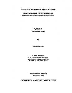
Space-time path and prism Although classical time geography recognizes telecommunication, it nevertheless focuses on physical rather than virtual interaction (we will comment in more detail later in this chapter). Two central time geographic concepts are the space-time path and prism. The space-time path traces the individual’s physical movement in space with respect to time. Figure 1 provides an example (Miller 2003). The path highlights the constraining effects of a person’s need to be at different locations at different times. It also highlights the role of transportation in mitigating these constraints. The slope of the curve illustrates the relationship between time and space in movement. A steeper slope indicates less efficiency in trading time for space, i.e., more time required per unit space in movement. The path is vertical when the individual is stationary in space. The space-time path can be applied at any temporal scale from real-time to a lifespan (Hägerstrand 1970). The space-time prism delimits the possible locations for the space-time path. Figure 2 illustrates a prism. Fixed activities anchor a space-time prism since (by definition) these allow only one spatial possibility during their duration. For example, the two anchoring locations in Figure 2 could be the person’s home (which s/he can leave no earlier than time t i ) and work (where s/he must be no later than time t j ). At some time during the time interval t ij = (t j − t i ) , the person must stop at some location to conduct an activity that will require at least a time units. Finally, the person can move with an average maximum velocity v . The interior of the prism is the potential path space: this shows the points in space and time that the person could occupy during this travel episode. A person cannot participate in an activity unless its space-time path (reflecting its location and available times) intersects the potential path space to a sufficient degree. The projection of the potential path space to geo-space provides the potential path area: all spatial locations that the person could occupy. A person cannot participate in an activity unless its location falls within the potential path area (ignoring the temporal duration of activities). The path and prism are the fundamental time geographic measure of individual accessibility, where this is defined as the freedom of activity participation in space and time. The number of paths allowed by a given fixed and flexible activity schedule is a surrogate for accessibility (Lenntorp 1976). We can also form accessibility measures that are a function of the prism size, or the activities and participation times allowed by a prism (Burns 1979; Miller 1999). The individual and space-time aggregates Time geography encompasses both the individual in space-time and the emergence of space-time aggregates created by the mutual interactions and adjustments of space-time trajectories and activities among multiple persons. A space-time project is a feasible ordering of atomic (indivisible) activities in space and time required to complete some overall goal. This can be applied at any scale including individual, neighborhood, urban, regional, national or global, as well as to varying social organization such as the family, work or community. The requirements for project activities to be sequenced and coordinated lead to the formation of space-time bundles or the convergence of space-time paths. Bundling reflects coupling constraints or the need to be coincident in space and time with other individuals to conduct an activity. Bundling often occurs at space-time stations or locations with resources or infrastructure to support the activity. Figure 3 illustrates two space-time paths bundling at
a station (represented as a tube). Activity systems emerge from the “ballet of adjustments” in spacetime activities among individuals cooperating or competing within a finite environment (Pred 1977). Contrasts with time use and activity analysis Besides its explicit treatment of space, time geography may appear similar to time use and activity analysis in economics and transportation science. However, there are several key differences (Pred 1977). Time geography encompasses time scales as long as a person’s lifetime as well as corresponding movements at the regional, national and international scales. While these scales may not be immediately useful to transportation researchers, time geography supports conceptual linkages between transportation and longer-term events such as migration and urban growth. Time geography also does not view time as an infinitely malleable resource that can divided, reconstituted and allocated at will by individuals: fixed events and travel velocities condition the ability to allocate time among competing activities. Classical time geography is also concerned with the space-time groupings and aggregates created by the interplay of multiple individuals and how these feedback to constraint individual activities in space and time. Finally, time geography explicitly rejects attempts to predict choices: understanding what a person cannot do is more insightful than understanding what they will do. Time geography and transportation research Despite difficulties in applying time geography to real world problems (see below), basic time geographic principles have proven to be useful in analyzing individual travel choice and aggregate transportation systems. Lenntorp (1976) shows that space-time accessibility measured by the number of possible paths allowed for a particular activity schedule in a given environment can provide insights into basic planning and policy questions. Burns (1979) uses the space-time prism to compare generic strategies for improving an individual’s accessibility to activities, including improving transportation efficiency, different network configurations, and scheduling policies such as facility operating hours. Thill and Horowitz (1997a, 1997b) show that incorporating time constraints into spatial choice models can improve their predictive power. Kwan (1998) shows that space-time constrained accessibility measures provide qualitatively different portrayals of individual accessibility compared with traditional methods such as the Hansen measure (Hansen 1959). Janelle, Goodchild and Klinkenberg (1998) use time geographic principles to determine the space-time ecology of an urban area from activity diary data.
Information Technologies and the New Time Geography Hägerstrand and his Lund colleagues developed time geography in the 1950’s and 1960’s, an era characterized by scarce, expensive data and weak computational platforms (although Sweden was unusually gifted with respect to biographic data). Classical time geography is hampered by unrealistic assumptions such as a maximum velocity that is uniform across space and time as well as difficulties in collecting data on space-time paths and activities. Classical time geography, while recognizing the possibility of telecommunication, focuses more on physical presence than telepresence (the ability to extend one’s reach in space and time through communication technologies).
The world has changed since the formative years of time geography. Data has become cheaper and more readily available. Efficient software exists for handling, analyzing and visualizing massive datasets, including geo-referenced data. The power of computing platforms has increased exponentially and will continue for at least the next two decades. Increasing deployment and adoption of communications technologies such as the Internet, World Wide Web, mobile phone and wireless Internet clients, as well as the development of location-based services (content provision based on geographic location in real-time), means it is increasingly difficult to separate transportation from communication when studying individual and aggregate travel demand. Researchers are re-examining time geography in light of new developments in information and communication technologies. The result is a new time geography that is more powerful and relevant with respect to application in the real world. This section of the chapter (based on Miller 2003) reviews recent contributions and research frontiers in the new time geography. Representation of space-time environments Geographic information systems (GIS) are software for managing, analyzing and communicating information about objects and events in geographic space. GIS allow representation and analysis of geographic objects and events at detailed levels of spatial (and increasingly, temporal) resolutions. Detailed digital representations of transportation networks allow researchers to relax the restrictive assumptions that the maximum travel velocity is stationary in space and time. A network time prism (NTP) is a space-time prism defined within a network with static (constant over time) travel times. A simple procedure exists for calculating the potential path tree (PPT): a NTP product that shows accessible nodes in a network based on the prism constraints (Miller 1991). The PPT resolves only to the nodes in the network: this can leave unrealistic gaps in network coverage, a weakness made more apparent by the development of address-based georeferencing methods in GIS. The potential network area (PNA) is an extension of the PPT that resolves to arbitrary locations in the network (Miller 1999). Figure 4 illustrates a PPT and a PNA defined within the northeast Salt Lake City, USA road network. The top half shows the reachable nodes in the network based on 15 minutes travel time from the designated location (indicated by a disc) while the bottom half shows the reachable network locations given the same origin and time budget. It is also possible to accommodate heterogeneous networks such as public transit systems with multimodal access (O’Sullivan, Morrison and Shearer 2000). NTPs with static travel times are an improvement over classical time geography but are still unrealistic. Flow and congestion vary over time, creating temporal variations in travel velocities. Congestion also propagates over space and time from localized incidences to wider areas. We cannot use time geography to answer questions about activity timing, “flextime” scheduling policies or demand management techniques such as Intelligent Transportation Systems (ITS) without incorporating timevarying flow and travel velocities. A dynamic network time prism (DNTP) is a space-time prism defined within a network with time-varying velocities and travel times. Wu and Miller (2001) develop a dynamic potential path tree (DPPT) that shows variations in accessibility in space based on the individual’s departure time in a network with discrete-time flow dynamics. Calculating DNTPs in networks with continuous-time dynamics is an open research question.
New methods for data collection Space-time activity (STA) data are space-time paths attributed with the activities conducted by the person. Collecting STA data traditionally involved cumbersome methods such as recall and activity diaries. Recall methods require individuals to remember and report activities at a later point in time (say, at the end of the day); this can create errors related to faulty or selective memories. Activity diaries are onerous to participants and suffer from under-reporting errors (Brog et al. 1982; Purvis 1990). Location-aware technologies (LAT) such as Global Positioning System (GPS) receivers or radiolocation methods that piggyback on wireless communication networks can allow collecting detailed space-time trajectories at the individual level (Smyth 2001). These space-time trajectories can be presented to individuals to improve recall of activities at a later time (Stopher and Wilmot 2000). LATs can also be combined with devices such as personal digital assistants (PDA) for recording activities directly in digital form. The user friendliness of PDAs will improve with continuing advances in natural language processing and voice recognition, potentially improving in-situ activity recording. Although current GPS receivers are bulky and consume power at a high rate; they must be linked to vehicles rather than individuals. Continuing improvements in these technologies will shrink the technology to the size of a microchip. This can allow personal rather than vehicular tracking in space and time. While this is a boon to our understanding of transportation and land-use systems, these technologies raise privacy and other ethical concerns. Location privacy methods such as locational masking can help resolve these issues (Armstrong, Rushton and Zimmerman 1999). The effectiveness of locational privacy methods and the spatio-temporal error induced in time geographic measurements are open research questions. Location-based services (LBS) refer to information content provision that is sensitive to a user’s geographic context, usually through wireless communication devices. LBS are another potential source of STA data since they require tracking of individual space-time paths (Smyth 2001). They also allow the marriage of STA data with an individual’s information queries, providing insight on the relationships between individual movement and information access. Using these data will require partnerships with LBS providers; time geographers can offer better support for space-time queries as well as adapting mobile computing services for likely demand patterns across space and time (see Miller 2003). New methods for data analysis A difficulty with STA data analysis is a combinatorial explosion of the information space. Interlinked activity dimensions include the number of activities, their sequencing, timing and locations, as well as the transportation/communication modes and possibly routes to access these activities. This implies an information space that is exponential with respect to choice dimensions (Ben-Akiva and Bowman 1998). Traditional methods for activity analysis require reduction of the information space for tractability. Econometric and statistical approaches and utility maximizing approaches require a priori specification and testing of multidimensional utility functions (see Kitamura 1984). Rule-based reasoning systems construct activity and travel schedules based on decision heuristics derived from cognitive science (see Garling, Kwan and Golledge 1994; Vause 1997). Simulation methods derive plausible choice sets and simulate individual choices from those sets (Ben-Akiva and Bowman 1998).
All of these techniques can only explore a very small subset of the complex and vast information space of space-time activities. New IT for data storage, integration and analysis can break the combinatorial barrier that has prevented full exploration and discovery of the spatio-temporal patterns in activity data. Data warehousing techniques are available for integrated and efficient storage of digital geographic data (Bedard et al. 2001); these database design and storage/access techniques must be extended to handle the temporal dimension of STA data. Exploratory visualization techniques for digital geographic data are emerging, but so far only a few techniques available that can address STA data (Kwan 2000). Data mining techniques for STA data include decision tree induction (Arentze et al. 2000) and multidimensional sequencing (Joh, Arentze and Timmermans (2001). Still required are effective data warehouse designs to support activity data in space and time. Data warehouses present unique challenges relative to designing transactional databases (operational databases used in daily work processes). For example, since warehouses need to support fast data retrieval along multiple data dimensions, they require high interconnectivity and redundant storage; these are bad properties for transactional databases with multiple users editing the database on a continual basis (Bédard, Merrett and Han 2001). Creating effective STA data warehouses requires solving complex issues in spatio-temporal data interoperability, including resolving different semantics, spatial and temporal referencing systems, geometry, accuracy and precision. Also required is research on standards for activity classification (including aggregation hierarchies) and effective indexing methods for the highly dimensioned STA information space. Extending time geography to cyberspace Although classical time geography recognizes the possibility of telecommunication, it still focuses on physical movement and transportation. Focusing only on physical movement is no longer viable in a world where transportation and telecommunication have altered dramatically the nature of space and time (Couclelis and Getis 2000; Janelle 1969). The popular “death of distance” argument is simplistic: information technologies such as the Internet, World Wide Web and mobile phones are complements as well as substitutes for transportation, increasing the level and complexity of travel demand. For example, a city guide webpage may induce a person to travel to a neighborhood or city that they have never visited before. Another example is cell phones creating “flocking” behavior where social interactions evolve fluidly over the course of an evening as calls are exchanged rather than being preplanned. Time geography provides a natural fit with emerging perspectives that view time as the scarce commodity within lifestyles and societies accelerated by information technologies (e.g., Gleick 1999). Extensibility diagrams are modifications of the space-time path that encompass movement and communication at all geographic scales (Adams 2000). Extensibility diagrams can illustrate general characteristics of the relationships between transportation and communication in activity participation. Individuals can be compared with respect to the frequency, duration, time and geographic scale of travel, incoming communication and outgoing communication. However, geographic space is restricted to only a crude ordinal scale (local, regional, national, etc). Still needed are tools with higher spatial resolution and the ability to support synoptic summaries among multiple individuals, as well as drill-down analysis and other exploratory and data mining techniques.
Classical time geography also ignores the use of communication and information technologies to reduce uncertainty through information search and learning. Uncertainty about transportation system performance (i.e., travel velocity) can induce earlier departures while uncertainty about the locations and attributes of activities can induce search behavior. Both can reduce accessibility by reducing the time available for other activities (Hall 1983). Kwan and Hong (1998) integrate cognitive constraints (e.g., preferences or lack of information) into a NTP through an effective but ad-hoc overlay procedure. Required is an extended research effort that reexamines time geography from its foundation and reformulates an analytical theory (similar to Burns (1979)) that recognizes imperfect information.
Conclusion Transportation and communication technologies exist to alter the relationship between geographic space and time, making it feasible for individuals to participate in activities in more locations and times. Because space and time are central to human existence, these technologies profoundly impact our lives and the world (Janelle 1969). Time geography is an elegant perspective for analyzing the interrelationships among activities in space and time, and the role of transportation and communication technologies in facilitating and constraining these interrelationships. While basic time geographic principles have proven to be useful in travel behavior and transportation research, the potential power of time geography is being enhanced tremendously by the rise of geographic information technologies such as GIS and LAT. Geo-information technologies allow more detailed representation of space-time environments, easier and more accurate space-time activity data collection and computationally-scalable methods for discovering new knowledge from massive spacetime activity data sets. The rise of new information technologies is also changing the real-world basis for time geography by blurring the boundaries between transportation and communication. A new time geography is emerging that has tremendous potential as well as imperative and fascinating research challenges.
References Adams, P. C. (2000) Application of a CAD-based accessibility model, in D. G. Janelle and D. C. Hodge (eds.) Information, Place and Cyberspace: Issues in Accessibility, Berlin: Springer, 217-239 Arentze, T. A., Hofman, F., van Mourik, H., Timmermans, H. J. P. and Wets, G.(2000), Using decision tree induction systems for modeling space-time behavior, Geographical Analysis 32 330-350 Armstrong, M.P., Rushton, G. and Zimmerman, D.L. (1999) Geographically masking health data to preserve confidentiality, Statistics in Medicine, 18, 497-525.
Bédard, Y., Merrett, T. and Han, J. (2001) Fundamentals of spatial data warehousing for geographic knowledge discovery, in H. J. Miller and J. Han (eds.) Geographic Data mining and Knowledge Discovery, London: Taylor and Francis, 53-73. Ben-Akiva, M. E. and Bowman, M. E. (1998) Activity based travel demand model systems, in P. Marcotte and S. Nguyen (eds.) Equilibrium and Advanced Transportation Modeling, Boston: Kluwer Academic, 27-46 Brog, W., Erl, E., Meyburg, A. H. and Wermuth, M. J.(1982) Problems of non-reported trips in surveys of nonhome activity patterns, Transportations Research Record, 891, 1-5. Burns, L. D. (1979) Transportation, Temporal and Spatial Components of Accessibility, Lexington, MA: Lexington Books. Couclelis, H. and Getis, A. (2000) Conceptualizing and measuring accessibility within physical and virtual spaces, in D. G. Janelle and D. C. Hodge (eds.) Information, Place and Cyberspace: Issues in Accessibility, Berlin: Springer, 15-20. Garling, T., Kwan, M.-P. and Golledge, R. G. (1994) Computational-process modeling of household activity scheduling, Transportation Research B, 26, :355-364 Gleick, J. (1999) Faster: The Acceleration of Just About Everything, Pantheon Books Hägerstrand, T. (1970) What about people in regional science? Papers of the Regional Science Association, 24, 7-21. Hall, R. W. (1983) Travel outcome and performance: The effect of uncertainty on accessibility, Transportation Research B, 17B, 275-290 Hansen, W. G. (1959) How accessibility shapes land use, Journal of the American Institute of Planners, 25, 73-76. Janelle, D. G. (1969) Spatial organization: A model and concept, Annals of the Association of American Geographers, 59, 348-364 Janelle, D. G., Goodchild, M. F. and Klinkenberg, B. (1998) The temporal ordering of urban space and daily activity patterns for population role groups, Geographical Systems, 5, 117-137. Joh, C.-H., Arentze, T. A. and Timmermans, H. J. P. (2001) Multidimensional sequence alignment methods for activity-travel pattern analysis: A comparison of dynamic programming and genetic algorithms, Geographical Analysis, 33, 247-270 Kwan, M.-P. (1998) Space-time and integral measures of accessibility: A comparative analysis using a point-based framework, Geographical Analysis, 30, 191-216.
Kwan, M-P. (2000) Interactive geovisualization of activity-travel patterns using three-dimensional geographical information systems: A methodological exploration with a large data set, Transportation Research C: Emerging Technologies, 8, 185-203. Kwan, M.-P. and Hong, X.-D. (1998) Network-based constraints-oriented choice set formation using GIS, Geographical Systems, 5, 139-162 Lenntorp, B. (1976) Paths in space-time environments: A time geographic study of movement possibilities of individuals, Lund Studies in Geography Number 44, Royal University of Lund, Sweden. Miller, H. J. (1991) Modeling accessibility using space-time prism concepts within geographical information systems, International Journal of Geographical Information Systems, 5, 287-301 Miller, H. J. (1999) Measuring space-time accessibility benefits within transportation networks: Basic theory and computational methods, Geographical Analysis, 31, 187-212. Miller, H. J. (2003) What about people in geographic information science? in D. Unwin (ed.) RePresenting Geographic Information Systems, John Wiley, in press. O'Sullivan, D., Morrison, A. and Shearer, J. (2000) Using desktop GIS for the investigation of accessibility by public transport: An isochrone approach, International Journal of Geographical Information Science, 14, 85-104 Pred, A. (1977) The choreography of existence: Comments on Hagerstrand's time-geography and its usefulness, Economic Geography, 53, 207-221 Purvis, C. L. (1990) Survey of travel surveys II, Transportation Research Record, 1271, 23-32. Smyth, C. S. (2001) Mining mobile trajectories, in H. J. Miller and J. Han (eds.) Geographic Data Mining and Knowledge Discovery, London: Taylor and Francis, 337-361. Stopher, P. R. and Wilmot, C. G. (2000) Some new approaches to designing household travel surveys: Time-use diaries and GPS, Proceedings, 79th annual meeting of the Transportation Research Board, Washington, DC, January 9-13, CD-ROM Thill, J.-C. and Horowitz, J. L. (1997a) Modelling non-work destination choices with choice sets defined by travel-time constraints, in M. M. Fischer and A. Getis (eds.) Recent Developments in Spatial Analysis: Spatial Statistics, Behavioual Modelling and Computational Intelligence, SpringerVerlag, 186-208. Thill, J.-C. and Horowitz, J. L. (1997b) Travel time constraints on destination-choice sets, Geographical Analysis, 29, 108-123. Vause, M. (1997) A rule-based model of activity scheduling behavior, in D. F. Ettema and H. J. P. Timmermans (eds.) Activity-based Approaches to Travel Analysis, Oxford: Elsevier Science, 73-88.
Wu, Y.-H. and Miller, H. J. (2002), Computational tools for measuring space-time accessibility within transportation networks with dynamic flow, Journal of Transportation and Statistics, 4 (2/3), 1-14.
List of figures Figure 1: A space-time path Figure 2: A space-time prism Figure 3: Space-time bundling Figure 4: A potential path tree (top) and potential network area (bottom)
Time
Work School Home
Geographical Space
t tj
a
tij
ti