National Council for Scientific Research, Center for Remote Sensing, Lebanon ... obstacles, a new satellite image segmentation method is developed using an unsupervised artificial neural network method ..... Prentice-Hall, New Jersey, 1996.
The International Arab Journal of Information Technology, Vol. 7, No. 2, April 2010
199
An Unsupervised Artificial Neural Network Method for Satellite Image Segmentation Mohamad Awad National Council for Scientific Research, Center for Remote Sensing, Lebanon Abstract: Image segmentation is an essential step in image processing. The goal of segmentation is to simplify and/or to change the representation of an image into a form easier to analyze. Many image segmentation methods are available but most of these methods are not suitable for satellite images and they require a priori knowledge. In order to overcome these obstacles, a new satellite image segmentation method is developed using an unsupervised artificial neural network method called Kohonen's self-organizing map and a threshold technique. Self-organizing map is used to organize pixels according to grey level values of multiple bands into groups then a threshold technique is used to cluster the image into disjoint regions, this new method is called TSOM. Experiments performed on two different satellite images confirm the stability, homogeneity, and the efficiency (speed wise) of TSOM method with comparison to the iterative self-organizing data analysis method. The stability and homogeneity of both methods are determined using a procedure selected from the functional model. Keywords: Artificial neural network, segmentation, unsupervised, remote sensing, satellite image. Received August 14, 2008; accepted September 25, 2008
1. Introduction Image segmentation is the process of image division into regions with similar attributes [10]. It is an important step in image analysis chain with applications to pattern recognition, object detection, etc. Until recently, most of the segmentation methods and approaches are supervised such as MAximum Posteriori (MAP) [8] or Maximum Likelihood (ML) [3] with an average efficiency rate of about 85% [9], [16]. In the supervised methods a priori knowledge is needed to get a successful segmentation process and sometime the required information may not be available. Satellite images are important source of information which is used in many environmental assessments and monitoring of agriculture, meteorology...etc., Compared to 1972, when Landsat Multi Spectral Scanner System (MSS) was launched satellite image systems now exhibit extraordinary diversity. There are operational satellite systems that sample all available parts of the electromagnetic spectrum with spatial resolution from 0.61 to 1000 m. Satellite image segmentation continues to be an important area in the research, which led to the publication of several methods in this domain. Self Organizing Map (SOM) or Kohonen’s Map is an unsupervised neural network method. Although the use of SOM in image segmentation is well reported in the literature, such as segmentation of printed fabric images [12], or in sonar images [13], their application in satellite image segmentation is not widely known. One can cite the work of [1] which was used in the
segmentation of Indian Remote Sensing (IRS) satellite image. Another promising work is the cooperation between SOM and hybrid genetic algorithm [2]. This approach shows good results when applied to different types of satellite images. However, the problem with this approach is the slow speed. The cooperative segmentation approach between K-means and SOM [17] is a recent work where the role of K-means is to segment the image in the coarser scale, and then SOM will re-segment the image in the fine scale. In This method K-means requires the pre-determination of cluster numbers and this kind of work can be taken care by SOM itself. In addition, this type of cooperation requires longer time to converge to an optimal solution. A known research [6] uses SOM incrementally to segment a Landsat image by first extracting features and then SOM is trained to segment these types of images. This method was attempted on one type of satellite images and for this method to provide accurate results a field survey must be conducted. The correct samples are provided to the SOM network for further training in a supervised manner. In this paper we present a new unsupervised method for segmenting satellite images. The proposed method uses both SOM and a developed technique known as T-Cluster. This new method is compared to another known commercial method the Iterative Self Organizing Data Analysis (ISODATA) and the results of both methods are verified for their stability homogeneity, and accuracy using a procedure implemented as part of the Functional Model (FM) [18].
200
The International Arab Journal of Information Technology, Vol. 7, No. 2, April 2010
The paper is structured as follows. In section 2, an overview of SOM and how it is implemented as part of the new segmentation method. In section 3, threshold clustering technique (T-Cluster) is presented. In section 4 TSOM segmentation method is explained. Section 5 covers ISODATA algorithm. Section 6 is devoted to experimental results. Finally, section 7 gives the conclusions.
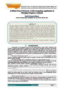
2. Feature Extraction Using Self Organizing Map Self Organizing Map (SOM) [5] is an unsupervised neural network method. SOM converts patterns of arbitrary dimensionality into the responses of two dimensional arrays of neurons. One of the important characteristics of SOM is that the feature map preserves neighborhood relations of the input pattern. A typical SOM structure is given in Figure 1. It consists of two layers: an input layer and an output layer. The number of input neurons is equal to the dimensions of the input data. The output neurons are, however, arranged in a two-dimensional array.
Figure 1. Self-organizing map.
Colors are one of the most important features considered in biological visual systems, since it is used to separate objects and patterns, even in conditions of equi-luminance [7]. SOM is used to map patterns in a three-dimensional color (multi-bands) space to a twodimensional space. In SOM, the input signals are ntuples and there is a set of m cluster units (automatic empirical determination with respect to the size of the satellite image). Each input is fully connected to all units. The initial weights are random and small, and their contribution for the final state decreases with the decrease of the number of samples [14]. The network is composed of an orthogonal grid of cluster units (neurons), each is associated with three internal weights for the three layers of the satellite image. At each step in the training phase, the cluster unit with weights that best match the input pattern is elected as the winner usually by using minimum euclidean distance as in equation 1.
x −Wl
k
= min x −Wi i
k
(1)
where x is the input vector, Wl
k
is the weight of the k
wining unit l at iteration k, and Wi is the weight for neuron i at iteration k. The winning unit and a neighborhood around it are then updated in such a way that their internal weights be closer to the presented input. All the neurons within a certain neighborhood around the leader participate in the weight-update process. This learning process can be described by the iterative procedure as in equation 2.
Wi k +1 = Wi k + H lik (x − Wi k )
(2)
H k li
where is a smoothing kernel defined over winning neuron. This kernel can be written in terms of the Gaussian function as in equation 3. H lik = α
k
exp( −
d 2 (l , i ) ) 2 (σ k ) 2
(3)
H lik → 0
when k�To, where To is the total number of iterations. α 0 is the initial learning rate and it is equal to 0.1. The learning rate is updated every iteration. σ k is the search distance at iteration k, initially can be half the length of the network or the maximum of either the width or length of the image divided by two. d (l , i ) is the distance between the leader neuron l and its neighbor i. As learning proceeds, the size of the neighborhood should be diminished until it encompasses only a single unit. After SOM neural network converges to a balance state, the original image is mapped from a high color space to a smaller color space. The number of colors in this space is equal to the number of neurons of SOM network. The final weights vectors in the map as the new sample space. This new data set is used for clustering, and allows determining a set of cluster centers.
3. Threshold Technique (T-Cluster) In order to eliminate small clusters (clusters with few pixels) and to reduce over segmentation problem the following technique (T-Cluster) is implemented. This technique consists of several steps as follow: • After obtaining cluster centers by SOM the process of clustering starts by calculating the distance between the values of the cluster centers representing the sum of the three bands. • Two clusters are combined if the distance between their centers is less than a predefined threshold T. • If step two is correct, the minimum number of pixels is considered in the combination procedure, where the cluster with smaller number of pixels is merged with the larger one. Figure 2 shows more
An Unsupervised Artificial Neural Network Method for Satellite Image Segmentation
201
details of the merging procedure and equation 4 explains the procedure of distance calculation.
d (V ( Pi ),V ( Pj ))