INTERNATIONAL BIRD STRIKE COMMITTEE
IBSC27/WP VIII-2 Athens, 23-27 May 2005
ASSESSMENT AND INTEGRATED RISK MANAGEMENT OF COLLISSIONS AIRCRAFTS TO BIRDS AT INTERNATIONAL CIVIL AERODROME OF KAVALA (N.E. GREECE) Lykos Vasilis 1 PhD, M.Sc., Hans Jerrentrup 2, Poulou Dora 3 M.Sc. & Eleftheriou Anastasios 4 Prof. Biological Department of University of Crete P.O. 2208, 71409 Heraklion of Crete, Greece 1 Doctoral Researcher candidate in assessment & integrated risk Management of Biological Resources, M.Sc. in coastal zone management Tel: 210 97 00 650, Fax: 210 97 00 650, Email:
[email protected] 2 Tel: 25910 23144, Fax: 25910 47 009, Email:
[email protected] 3 Tel: 210 8074368, Fax: 210 8074368, Email:
[email protected] 4 Tel: 2810 34 68 60, Fax: 2810 24 18 82, Email:
[email protected]
Abstract Collisions between aircraft and birds (bird strikes) are a concern throughout the world because they threaten passengers’ safety, result in loss of revenue and costly repairs to aircraft and can also erode public confidence in the air transport industry as a whole. This study funded by the Hellenic Ministry of Transportation and Communications and the Hellenic Civil Aviation Authority, concerns aerodrome of Kavala which is adjacent to Nestos’ wetlands, one of the most fundamental refuges for migrating avifauna in Greece. According to International Civil Aviation Authority (I. C. A. O.) data, this airport runs greater risk of having a bird strike (39%) among all the civil airports in Greece, with an increase between May to September. This on going study, estimates bird abundance, distribution, movement patterns and their habitat attractors at Kavala airport and within an 3.2 km radius, which is the “bird critical zone”, with a view to assess current air-strikes hazards in real time and also to provide wildlife hazard management plans through the modifications of habitat and food sources potentially related with bird hazards. The detection of birds in real time depends on time – area field surveys and also on the development of a prototype modified surveillance radar for obtaining ground track data and consequently, bird temporal and spatial flight patterns. Keywords: bird strikes, risk management, aircraft, aerodrome, flight safety, modified surveillance radar.
1. INTRODUCTION Collisions between aircraft and wild avifauna are a concern throughout the world because they threaten passengers’ safety (Thrope 1977), result in loss of revenue and costly repairs to aircraft (Milsom and Horton, 1990; Linnel et al., 1996; Robinson, 1997) and can also erode public confidence in the air transport industry as a whole (Conover et. al., 1995). Most wildlife strikes do not result in fatalities but safety hazards exist and the proportion of wildlife strikes that result in damage is substantial. Wildlife hazard assessment provide a framework trough which a site – specific understanding of wildlife hazards on an airport is developed. Wildlife hazard assessment typically should cover at least one full year because wildlife populations, especially migratory birds exhibit seasonal fluctuations in behavior and abundance. This on going study, which undertaken by the Biology Department of University of Crete. And funded by the Hellenic Ministry of Transportations and Communications – Hellenic Civil Aviation Authority, is developing baseline data on wildlife populations and their flight behavior and species 1
IBSC27/WP VIII-2
ecology as well as wildlife strikes at International Civil aerodrome of Kavala (M. Alexandros) which located in N.W. Greece. The term “assessment” refers to four objectives: 1) Estimation of bird abundance, species, flight patterns and height above ground and their ecology, 2) Assessment of habitats and food sources related to wildlife hazards at or in the vicinity of the airport, 3) Review and analysis of available wildlife records 4) Land uses and food sources off airport property related to wildlife hazards. However since wildlife strikes management depends on a multi criterion analysis included operational, environmental and socio-economic analysis of the area reveal the need for an integrated management under the framework of the “Sustainable Development” principle. The need for integrated management of bird strikes is greater if we bear in mind that aerodrome of Kavala has constructed in a typical coastal zone area (general practice for constructing aerodrome in Greece and other countries), lain in the surround area of Nestos’ Delta, one of the most important wetland in Greece which protected by a multi laws framework of National and European acts. The coastal wetland zone is a dynamic system, unusually rich in the diversity of nature resources. Thus the variety of activities found within its boundaries, suggesting that the potential for unsatisfactory interactions and outcomes, both economic and environmental, is much grater than for certain other natural resources with considerable potential gains to be obtained through effective integrated management. Integration is taken to mean the harmonization of conflicting interests, toward a common goal of conservation and sustainable development of the whole area associated with the bird strikes management and flight safety. The transition from bird strikes’ management and development of the area to conservation, according to RAMSAR Convention concept of the “wise use of wetlands in their territory”, as well as the sustainable utilization of natural resources and their reflection in planning and integrated management practices, is examined in light of the socio-economic appraisal of coastal environments and processes as either resources or hazards (Lykos et al., 2001). Simultaneously, this study is striving for implementation of sustainable bird strikes’ mitigation management plans in parallel with the appropriate utilization of the wetland natural resources, under the framework of the mitigation of conflicts between aerodrome land use and opponent ones. This appraisal depends strongly on the historical value of the area, the effectiveness of new proposed legal, economic and administrative planning instruments, and the willingness of institutions, nongovernmental organizations, municipal and local authorities and social agencies, presented in the area, to participate in such an effort. 2. WHY INTEGRATED MANAGEMENT PLAN IS NEEDED: ECOLOGICAL EFFECTS AND MULTIPLE – USE CINFLICTS The major reasons why an integrated approach is needed for managing bird strikes are twofold: 1) the effects of coastal uses as well as activities further upland, can have on coastal environments related to wildlife hazards and flight safety and 2) the effects of coastal land users can have on one another and especially on aerodrome land use regarding bird hazards.
2
Lykos, Jerrentrup, Poulou & Eleftheriou
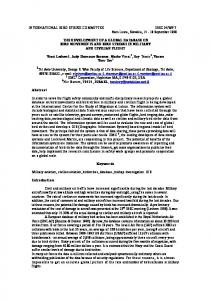
Human Constituents (Stakeholders)
Direct Airport operation Coastal industries Coastal residents Interest group
Coastal environment
(Natural science) (Social science) Scientific community
Indirect Inland residents Interest groups Policy and Management Organizations International State National Local Regional Private sector
Figure 1: Cultural ecology of coastal Public Policy affecting bird hazards' management plans Coastal development activities (building of structures, dredging, pumping, etc.) such as we have on Nestos’ Delta, can significantly affect the ecology of coastal zone and the functioning of coastal processes and resources and them with their term the implementation of wildlife hazards management plans. For example, development activities in beach and dune areas can change patterns of sediment transport or alter inshore current systems which affect bird’s nesting, create landfills and garbage which attract birds and diking for agriculture can affect the functioning of wetlands through reduced freshwater inflows and through changes in water circulation which with its term may have an impact on fish and accordingly bird populations. Activities further inland, such as logging, agricultural practices (e.g. burning of cane sugar) and animal husbandry practices (e.g. pollution of stream by animal waste), represent important sources of bird hazards. Two major types of conflicts related to coastal resources can be noted: 1) conflicts among users over the use or nonuse of particular coastal areas and 2) conflicts among government agencies that administer projects or functions related to the coastal areas. By users we mean both direct, actual users of the cost (e.g. Hellenic Aviation Authority / airport manager for the operation of Kavala airport and surrounding farmers) and indirect or potential users (e.g. customers of aviation companies, environmental groups that promote the no utilitarian values of the coast, members of public who live in other areas, conservationists and environmental volunteers for wildlife species protection and future generations. Because most marine resources are public property and there is an important public or societal interest of the land side of coastal zone, the rights and interests of such indirect users must also be taken into account (Cicin-Sain, 1992). Some typical manifestations of conflicts among users involve: 1) Competition for coastal space; 2) adverse effects of one use such as fisheries which attract birds on another use such as airport operation; 3) adverse effect on ecosystems which may alter many bird species behavior and 4) effects on onshore systems which may affect in one or another way flight safety. Conflicts also occur among government agencies that administrate programs or services, including both interagency conflicts (among agencies at the same level of government, whether national, provincial or local and intergovernmental conflicts or among different levels of government). 3
IBSC27/WP VIII-2
Agency conflicts occur for a variety of reasons, including divergent legal mandates and different missions: differences in agency outlook and type and training of personnel; differences in external constituency groups; and lack of information of communication (Cicin-Sain 1992).
3. METHODOLOGY 3.1 Methodology for integrated management The general methodology that is applied, combines descriptive parts, on the history and the current situation at a particular site off airport property, with the analysis and assessment of existing factors which have an impact, directly or indirectly, on wildlife hazards. The analytical part include an evaluation of the factors which have contributed to the current state, proposals for future actions, and an a priori assessment of the factors which may influence future developments of the area related to wildlife hazards (Figure 2)
Description
Diagnosis
1. Location of the area in the greater geographical context around the airport
Risk analysis
2. Development of the area in the past, particularly since the construction of the airport 3. Description of the present state of the area as a whole
Risk assessment
5. Tendencies and consequences of future development in the area related to wildlife hazards, directly or indirectly
4. Diagnosis of the present state and assessment of the contributing factors (operational, environmental, socioeconomic) from which the present state results
6. Diagnosis of the resulting future state and assessment of the factors (natural, social economic & political) which contribute to the future situation
Risk Management
7. Proposals for integrated bird risk management of the area
8. Evaluation of the proposals under 7 and diagnosis of the future state to strive for
Figure 2: Methodology applied for the integrated bird risk management of the area off the airport of Kavala
4
Lykos, Jerrentrup, Poulou & Eleftheriou 3. 2 Site – specific Methodology
3. 2. 1 Airport description The airport of Kavala - Hrysoupolis (“Megas Alexandros”) is located in the Western part of the Nestos Delta, that is in North-east Greece, about 200 km to the east of Thessalonica. The airport is a 400-ha public facility located in southeast Greece (and 7 km east of Kavala city), in Prefecture of Kavala, North Greece. The local climatic conditions are characterized by hot summers and mild winters. Average low/high temperatures range from approximately 3 oC/6.1 °C in February to 25.6 oC/26.1 °C in July. The average annual rainfall is 56.3 cm. The airport is built in 1981 and is located approximately 200 – 1000 m of the seashore where there are many wetlands. Aerodrome of Kavala services the commercial air career and transport industry, general aviation and military aircraft but the ownership belongs to Hellenic Air Force. Aerodrome of Kavala has increasing operations during the summer and especially in July and August (almost 500-600 operations for each month) thanks to augmented tourist movement. Operations are defined as any take off or landing by a fixed-wing aircraft. Approximately 70% of aircraft operations involved commercial passenger aircraft, 14% air transport (commercial shuttle aircraft and cargo), 15% general aviation (private aircraft, helicopters etc) and 1% military aircraft (Hrysoupolis squadron- Hellenic Air Force). 3. 2. 2 Wildlife strike records We examined the bird strikes reporting forms of the recording bird strikes of the previous years and we emphasized in the recording altitude (phase of flight) and the species of them. Then we calculated the ratio of recording bird strikes per 10,000 aircraft operations which are used as indices of wildlife hazards at airports (Blokpoel, 1976). Most airports account for less than 20% of actual strikes (Dolbeer et al., 1995). We noticed that during the last couple of years we have an augmented trend of recording bird strikes with a peak in 2004 (the ratio was > 20%!) 3. 2. 3 Definition of study area at and in the vicinity of aerodrome We examined wildlife patterns and the ecology of potentially dangerous birds within an 8-km radius (general zone) of the runway centerline at Kavala because most bird – aircraft collisions occur when aircrafts are at low altitudes. Turbine powered aircrafts normally reach 601 m. above ground level (AGL) before leaving the general zone and 88% at least in the USA, of bird strikes occur below 610 m. AGL (Clearly et al., 1997). We emphasized areas within the 3.2-km radius of the runway centerline (critical zone) because turbine powered aircraft are usually under 150 m AGL and 72% of the USA bird strikes occur at or below this level (Clearly et al., 1997). Beside, we wanted to have a good knowledge about the relations between “dangerous birds” and habitats at these areas because represent the boundaries of the future proposed zoning around the airport for the mitigation of bird hazards We covered the above zones with 1500 m. radius of the observer, 22 observation points which include all the type of habitats around the airport (the whole case study area covers a surface of 168 Km2 around the airport and each observation area covers 7 Km2 ). In order to register the bird number a so called horizon scan was carried out once a week between November 2004 and August 2005. In app. 5 minutes the horizon was scanned 360o in radar like way using a tripod mounted binocular (10X42) with an aperture of 6.3o slightly in height of the binocular position and angle with the ground. Distance was estimated in three classes; 0-500 m., 500-1500 and >1500 m. Altitude was estimated in 4 classes, based on the 4 quarters of the binocular view (de Hoon & Buurna, 2000). The height of observation point, angle with the ground and aperture of 6.3o resulted in an observed altitude range of 0 to 61.2 meters for distance 1 and 0 to 163.7 m for distance 2.
5
IBSC27/WP VIII-2
3. 2. 4 Time - area count survey The time area count survey was based on the USFWS breeding bird survey (Robbins et al., 1986). Birds were surveyed once per week. The start time of each count alternated between dawn and dusk every other week to monitor the crepuscular period of bird use. The survey was reversed biweekly. Bird numbers observed, activity (categorized according to flying, loafing etc.), habitat type and any other pertinent observations (time, wind speed and direction, temperature and weather conditions) were recorded. In our surveys, the number of small solitary birds may have been underestimated in favor of the larger, more visible flocking birds. We accepted this because our objective is to establish an index of abundance and activity of the most hazardous species (Servoss et al., 2000). 3. 2. 5 Remote sensing In order to confirm our field surveys data we used an S-band radar for monitoring of potentially dangerous birds in real time. The detection of birds in real time depends on the development of a prototype modified surveillance radar for obtaining ground track data and consequently, bird temporal and spatial flight patterns. This radar has a color Doppler system, allowing one to easy distinguish targets and see track history trails in different colors. Using some relatively straightforward tuning techniques, the researcher could easily see individual medium - and large - sized birds and migration streams. This is an ongoing research.
4. RESULTS 4. 1 Protection and Legal Designation At the eastern part of Kavala airport there is the Nestos delta which is protected by several national laws, EU-Directives and international treaties. But it has to be taken into consideration that in this region there is a great discrepancy between the legal protection levels and the practical implementation, both with regard to species protection and especially conservation of biotopes and management. Some local protection directives exist concerning hunting restrictions, concerning two large non hunting zones including the whole Nestos riverbed inside the delta and the Thasopoula island between the mainland and Thassos island of together about 9,500 ha. There are two totally protected, fenced areas in the Nestos riparian forest of about 800 ha, especially for the last European population of the wild Pheasant (Phasianus c. colchicus), where no visitors are allowed to enter or any change of the habitat or wildlife is allowed. 4. 1. 1. National Ministerial Decree of 16th September 1996 A ministerial decree dated 16 September 1996 (854/B/5796/1996) defines the Nestos Delta and both easterly bordering wetlands Lakes Vistonis and Ismarida (= Mitrikou Lake) as “National Park of East-Macedonia and Trace”. Initially this decree was valid for two years and was renewed once for one more year and has expired in September 1999. This decree serving for the implementation of the postulations of the Ramsar Convention and the European Wild Birds Directive as well as the FloraFauna-Habitat Directive, contains, however, grave errors concerning the definition of the protection zones and the boundaries of the protection zones. A new ministerial decree is in preparation and due to be signed in 2005 for the national park. And also in June 2003 a “Management Body” was created – consisting of 11 representatives from various local authorities, regional and national government and NGOs for the administration and promotion of the park.
6
Lykos, Jerrentrup, Poulou & Eleftheriou 4. 1. 2. International Ramsar Convention Greece joined the Ramsar Convention in 1974 - Greek Law 171/1974. The "Nestos Delta and the adjacent Lagoons" received the Ramsar designation on 21st August 1975 and is since then one of the 11 Greek Wetlands of International Importance according to the convention. The designated protection area comprises the extensive delta complex, including freshwater lakes (in the first bordering included – later excluded!), salt marshes, coastal lagoons, dune systems and the largest remaining area of riparian forest in Greece – the famous “Kotza Orman” in the Nestos riverbed. A variety of severe environmental and administrative problems led to the inclusion of the Nestos Site in the “Montreux Record” - a kind of “black list” of sites with intensive environmental problems on 4th July 1990. The missing of detailed boundaries and a surveillance and management authority, the decrease of the groundwater levels due to growing irrigation demands and dam construction upstream are only the most striking problems. It is aimed by the Greek Government to remove the Nestos Delta from the Montreux Record as soon as the basic problems are solved and a concrete management structure is in force. EU Wild Birds Directive The Birds Directive, valid in all EU countries (Directive EWG/79/409) contains annexes naming the all-year protected birds as well as rare and threatened Greek species. Since joining the EU in 1981, Greece has been obliged to protect the breeding and feeding places of these species and to create “Special Protected Areas” (SPAs) according to the directive. The Nestos Delta is one of the first Greek SPAs proclaimed by a decision in 1986 (Law No. 1643/86). Flora-Fauna Habitat (FFH) Directive The FFH-Directive (EWG/92/43) postulates the protection of all areas comprising rare species or habitats in the EU. The list of areas in Greece contains all important wetlands, including the Nestos Delta (No.: GR1150010, GR1150001 & GR1150002) But, contrary to all original surveys and studies published, in the above mentioned Ministerial Decree (KYA) setting aside the National Park, the “National Park of East-Macedonia and Trace”, the Nestos lakes were not included into the protection zones A or B, but only in zone C. On the other hand they are mentioned in the text of the Natura 2000 document explicitly as particularly rich habitats and of great conservation value! Berne Convention The Berne Convention on the Conservation of European Wildlife and Natural Habitat was fully adopted in 1983 by the Greek legislation (Law No. 1335/1983). Due to the occurrence of many species in need of protection, the convention has to be applied to the Nestos area as well. Important Bird Areas (IBAs) In the list of “Important Bird Areas” (IBAs) – a preparatory work for the implementation of the “Wild Birds Directive” of Europe - the Nestos Area is listed as well but it has no legally binding character. 4. 2 Landscapes The wider area of aerodrome and Nestos delta is surrounded by a number of other most important natural sites like the Nestos Gorge (a protected “Aesthetic Forest Area” with the status of an SPA and a Natura 2000 Site), the Central Rhodopi Mountains with most extended mixed mountain forest areas with a small population of Brown Bears (also a protected site as “Natural Monument” with the status of an SPA and a Natura 2000 Site), the Natura 2000 Sites Mt. Falakron and Mt.Pangeon, the rich Mediterranean island of Thassos (3 Natura 2000 Sites GR115006, 115007, 115008) and the
7
IBSC27/WP VIII-2
neighbouring wetlands of Vistonis and Ismarida Lakes (Ramsar, SPA and a Natura 2000 Sites; part of the proposed Wetland National Park, areas with multiple conservation status).
Table 1: Geographical & ecological Data and Coordinates of surrounding landscapes of airport of Kavala and Nestos Delta Description Number of Lakes and Lagoons
Data 7 lakes, 11 ponds 8 lagoons 30 km of riverbed 50 km of coastal sand dunes total wetlands and (semi-) natural areas ca. 10,000 ha Wider lakes and ponds area 1300 ha of natural and semi natural areas including ca 50 % intensively farmed agricultural area Size of Vassova and Eratinon Lagoons About 400 ha and 750 ha respectively Maximum depth Lakes: 3.5 m Lagoons: 1.8 m Elevation (above sea level) Lakes: 16 - 21 m Lagoons: 0 m Salinity of the lakes and ponds Freshwater Salinity of the lagoons Slightly brackish to saline – hyper-saline, depending on season and location Precipitation 450 – 580 mm per year Mean annual temperature 10.8° C Location North-eastern Greece Longitude: 400 56´ - 400 58´ N Latitude: 240 30´ - 240 59´ E 4. 3 Habitats The following key units of natural and semi-natural habitats were classified for the surrounding area of aerodrome of Kavala including also the anthropogenous areas: 4. 3. 1. Coastal Lagoons Eight shallow coastal lagoons with extended salt marshes, wet meadows and tamarix scrubs, consisting of the following habitats and plant communities: •
Open waters of the lagoons
•
Mudflats
•
Saltmarshes (Salicornietum, Arthrocnemetum)
•
Brackish marshes (Juncetea maritimi)
•
Tamarix bush (Tamaricetum) 4. 3. 2. Freshwater Lakes and Ponds
In total 18 small lakes and ponds in the area of Hrysoupolis with large reed beds, water lilies, floating vegetation, dry and wet meadows and mixed bush forest, small bushy forest patches (and traditional agricultural fields), consisting of the following habitats and plant communities: •
Lakes and ponds (7 lakes and 11 ponds)
•
Reed beds and bulrushes (Phramitetea)
•
Swimming and floating vegetation (Lemnetea, Potametea, Nymphaeion)
•
Dry meadows (Cisto-Micromeretalia)
•
Bush forests (Coccifero-Carpinetum orientalis)
8
Lykos, Jerrentrup, Poulou & Eleftheriou The lakes and pond area of near Hrysoupolis Town are outside of the 8-km circle around the airport. But as they are important breeding, feeding and wintering sites for water birds, that enter also the area, they are shortly described here. 4. 3. 3. Nestos Riverbed The Nestos riverbed, including sandy islets, is still the largest Greek riparian forest ecosystem with branches of running and still waters, oxbows and a large variety of biotopes at the river mouth with wet meadows, reed beds, tamarix scrubs, inland sand dunes, etc., consisting of the following habitats and plant communities: •
Soft and hardwood riparian forest (Populetalia, Alno-Ulmion)
•
Islands (Salicetum albo-fragilis)
•
Banks and sandbars
•
Oxbows (Periploco-Alnetum glutinosa)
The Nestos River Area is also outside of the 8-km circle around the airport, but is the second most important site for breeding, feeding and wintering of water birds in the Nestos Delta. Several species, like Cormorants, Gulls, Herons and some raptors use regularly the river and the lagoon areas, moving along or across the airport area. 4. 3. 4. Coastal Sand Dunes An extended zone of about 50 km coastal sand dunes which are the largest in Northern Greece, consisting of the following habitats and plant communities: • Shoreline (Cakiletea) •
White dunes (Ammophiletea)
•
Grey dunes (Ephedra-Silene)
• Inland dunes (Tertiary dunes) The coastal dunes along the lagoons have only for some few species a great importance, like Oystercatcher, Terns, Gulls, Plovers and sometimes for Harriers and Buzzards. For the Observation Points 2, 3, 10, 11 and 13 these vegetation types are added up as “Coastal Dunes”. 4. 3. 5. Anthropogenous Areas Today most of the Delta consists of intensively farmed arable land. After constructing irrigation channels and drainage ditches, land consolidation programmes created large rectangular fields with tracks, a cultural steppe without hedges and copses. The poverty of these areas as habitat is reflected in reduced species diversity. The drainage ditches and irrigation channels in the Nestos Delta are also of some ecological interest. In some respects, they fulfil the function formerly provided by the subsidiary branches of the Nestos. They supply the Delta with fresh water. Indeed, the ditches, often filled with reeds and bulrushes, harbour a rich wildlife and support some of the bird species, like Puple Heron, Little Bittern and White Stork as feeding grounds. The following anthropogenous habitats are classified: •
Planted poplar forests (Populus canadensis, hybrid)
•
Agricultural areas with crops or meadows
•
Ditches, channels, irrigation and drainage canals
•
Dikes, dams, field roads
•
Hedges
•
Housing areas, villages, settlements, gardens
•
Dumps and ruderal areas
•
Sand and gravel pits
9
IBSC27/WP VIII-2
•
The rocky offshore island Thasopoula with its Mediterranean vegetation is closely related to the delta and hosted the largest northern Greek colony of “Yellow-legged Gull (Larus cachinnans), that are by far the most commonly observed bird species during this study. The breeding colony was lastly counted in the Mid-1990-ies and at that time estimated to be at least 3500 pairs. The population was calculated to be roughly 15000 – 20000 birds. There are strong indications, that the colony is now far larger, providing the whole Nestos region – including the airport – with many thousands of birds. A large percentage follow the coast lines from Keramoti East end Northwest, especially to the area of the old garbage dump of Kavala close to Vassova Lagoon, just in the North of the airport.
There is also a significant breeding colony of Little Egrets (Egretta garzetta) on the Island, birds that feed mainly in the area of the coastal lagoons and the rice fields of the western and southern Nestos Delta.
•
In near distance, the Nestos Gorge shows a great variety of biotopes from different vegetation zones. The steep cliffs and deep slopes host a rich fauna of raptors and other predators that feed also in the delta and soar especially along the mountain slopes. 4. 4. Biodiversity
The avifauna of the area is very rich; up to now more than 320 bird species have been observed, of which about 110 are breeding species and more than 180 are migrants and about 120 are winter visitor species. The nesting avifauna includes 4-5 pairs of Lesser-spotted Eagles in the riparian forest, 1 pair of White-tailed Eagle, 50 % of the European population of Spur-winged Plovers (25 pairs), a few colonies of Grey & Purple Herons, Little Egrets, Little Bittern, Little and Common Terns, Pratincoles, Stone Curlews, about 90 pairs of White Storks and recently up to 500 pairs Mediterranean Gulls, Masked Shrike, Hoopoe, Bee-Eater and Syrian Woodpecker are common. The delta is a very important stop-over place for the Palaearctic bird migration for raptors, waders, terns, storks, herons, pelicans, Glossy Ibis, Spoonbills and many songbird species. Wintering species of aquatic birds such as ducks, geese, swans, divers, plovers, Pygmy cormorants may reach 50,000 individuals. Important numbers of large raptors like Imperial, Spotted and White-tailed Eagles and many harriers winter here. In Nestos Delta holds still good populations of otters and wild cats and hosts about 40 -50 % of the countries total Golden Jackal population; while Wolf is very rare, the Brown Bear, Red and Roe Dear are extinct since 50 years. Also the populations of Otter and Wild Cat are about the best in the whole country (Jerrentroup, 1997) 4. 5. Agriculture in the Nestos Region (Prefecture of Kavala) Agriculture plays an important role in vast parts of Greece. About 19.2 %of the active population is working in this sector, 11 % of the BIP is coming from agriculture. This sector is supplying the market with raw material and food. Directly connected to agriculture is the manufacturing industry such as food industry, tobacco producing industry, the textile sector as well as the tourism sector. The agricultural sector plays an important role particularly in rural areas and regions of little development in view of tourism or industry like the Nestos region. A problem of the region consists in the extremely high number of small businesses, over 70 % of all agricultural businesses are smaller than 4 hectares. Over 60 % of the owners are older than 55 years and often a successor for the farm is not ensured. The soil is a mixture of sand and clay and varies from relatively coarse to very coarsely grained. The regions is characterised by the cultivation of maize, cotton, winter crops, sugar beet, and rice. Additionally asparagus, water melon and beans are being cultivated. Almost all fields are systematically irrigated. The irrigation network is fed by the Nestos River, the Paradisos source and a number of groundwater wells.
10
Lykos, Jerrentrup, Poulou & Eleftheriou The climatic conditions allow the planting of a large number of agricultural products such as corn, rice, cotton, oil seeds, tobacco, fruits and vegetables; following a table with the most common crops for the Kavala District (including Thassos). In the irrigated lowlands of Nestos Delta especially corn, asparagus, rice, kiwi, sugar-beat and beans are farmed. Agricultural practices and selections of crop species have a large impact on the attractiveness to birds: e.g. ploughing or other earth-preparing measures may attract for a short period of time (days) many birds, especially gulls and craws. Other practices like flooding rice fields in May also attract many birds (various gulls, waders and egrets). While some crops them attract birds like melons, honey-melons and cherry trees (starlings). While in winter the harvested rice fields around the airport offer food for seed-feeding ducks and geese as well as amphibians/small fish for herons and small raptors. 4. 6. Habitats of Observation Stations 4. 6. 1. Ecological Grouping of Observation Points For the better handling of the field observation data a grouping of observation points, according to their geomorphology, habitat structure and vegetation has been made: The observation points No: 2, 3, 10, 11, 13, 22 are costal sand dunes with good visibility around, sparse vegetation of psamophyte species, all points have view over the costal lagoons of the western Nestos Delta and the open sea (about 50 % of panorama), vegetation plays a minor role for the flying birds in these habitats; but the open water surfaces (lagoons and sea) are wetlands of “International Importance according to the Ramsar Convention” and have great importance for waterbirds in the broad sense during migration, wintering and breeding and are being used for feeding, roosting and reproduction areas, partly very close to the airport; birds in this area are seen of many different taxa, mostly ground oriented: swimming, feeding, roosting or low movements around the site, but also incoming and outgoing groups or singular birds observed in the winter and spring months mainly from the following : Cormorants, Pygmy Cormorants, Pelicans (both species), Divers, Flamingos, Ducks (12 species) Coot, Herons (4 species), raptors (7 sp), craws (4 sp), waders (8 sp). The main flight directions at these observation points are parallel to the water-bodies, mainly NW and SE; only in winter some flocks of ducks fly in W – E directions, as they roost during daytime far outside in the sea and come for feeding to the lagoons during the afternoon. The observation points No: 1, 4, 5, 7, 8, 9, 12, 21 are agricultural areas closer to the airport with large percentage of rice cultivations, ditches with reed and with high water table, close to the wetlands and surrounding the airport, with large – medium importance to birds and only for some groups for feeding on the fields, like gulls, craws, herons, starlings, some passerines and ducks-geese in winter; following the above group are some species of raptors like Marsh- and Hen Harrier, Buzzard, Kestrel and Sparrow Hawk. Flight directions are not clearly towards some main routes and vary a lot according the location of the observation point, to weather (mainly wind) and agricultural activities (see chapter 1.12 agriculture, page 15). Observation points No: 6, 14, 15, 16, 17, 18, 20 are intensively used agricultural areas with irrigation and drainage ditches, small-medium size planted tree cultivations (poplars), few hedges and few other natural structures with minor importance for birds only again for feeding on the fields, like gulls, craws, herons, starlings, some passerines; here the agricultural set-a-side poplar plantations widespread over the plain give additional habitat for small-medium size raptors and craws to breed. Again there are no main flight directions. Observation point 19 is on the hill foot with dryer cultivations, some olive groves and the new Egnatia road, with low importance for birds, except for some olive groves and other fields that are sparsely used by gulls, craws, starlings and small raptors.
11
IBSC27/WP VIII-2
4. 7. Qualitative Data on Bird Observations
The following summarizing statement on the observed bird species can be made, more out of the general observations at the observation points, than from the rather pure data sets of the regular counts. The main species groups of birds flying everywhere, at all times of the day, in small and large numbers and also sometimes in great height are the Gulls (Larus cachinnans, L. ridibundus and few L. genei), The second most common group are the crowids including (Corvus corone, C.monedula, C. frugilegus and Pica pica), Raptors are birds that are often seen to soar and even also in great height, using mainly open areas (marshes and agricultural fields) and hunt various birds also above the lagoons and even the sea; Buteo buteo, Circus aeruginosus, C cyaneus, Falco tinnunculus, F. peregrinus, Aquila clanga, Accipiter nisus in winter and A. brevipes in spring are the most common species. In the coastal area, especially at the lagoons, but also inside the airport area many observations of herons were made; in the winter months mainly Ardea cinerea, Egretta alba and a few E. garzetta; while in spring Egretta alba migrates away, E. garzetta and Ardea cinerea are very common and Ardea purpurea and some Nycticorax nycticorax can be observed. The Cormoran (Phalacrocorax carbo) is a very common species in winter appearing also in large numbers and in long chains coming and goint to the roost sites, that are located in the area of the Nestos main river bed, moving mainly over the sea along the shore, but also above the lagoons. There are observations of large flocks of birds flying W – E from the northern 2 lagoons Vassova and Eratino alongside the airport going over Hrysoupolis to the Nestos. The Pigmy Cormorant (P. pygmaeus) is much smaller and flocks are also nowadays smaller and they feed in the lagoons and ditches of the coastal area, while their roost is in the Keramoti area and movements follow mainly the coastline. P.aristotelis can be seen only in the sea, flies always very low and appears in small groups. Flamingos (Phoenicopteus ruber) move only along the lagoons (NW – SE) and sea coast and fly at rather low height. Both species of European pelicans(Pelecanus crispus, P. onocrotalus) have been observed at the lagoons – never during the flight counts, but may soar in large groups of up to 70 birds (usually in the late morning or early afternoon hours) very high over the area when they begin movements/migrations to other places. Ducks (Anas clypeata, A. platyrhynchos, A. crecca, A.querquedula, A. penelope, Aythia ferrina, A. fuligula and Tadorna tadorna,) are seen to move around a lot in the winter months, especially during weekends when the hunting pressure is very high. Flock size is between a few up to 300 birds, and the main flight directions are parallel with the lagoons of from and to the open sea, where they roost during daytime or when there is a high degree of disturbance from hunters. During this (mild) winter 2004/2005 only a few observations were made of geese in the lagoon – agricultural area of the western Nestos Delta, mainly Anser albifrons. Geese often feed in the rain flooded rice fields and roost during daytime at the lagoons or even on the open sea; sometimes flocks move over the airport area towards the Nestos mouth area where thei night roosts are. The Coot (Fulica atra) is very common in winter at the lagoons with many thousand birds, but they almost never fly higher than a few meters over the water. Also divers are present in large numbers and a variety of species but almost never fly. Waders (mainly Tringa totanus, Gallinago gallinago) in winter and many other species during spring migration were observed, almost only outside the regular counts and usually very low but enter regularly the flooded areas of the airport for feeding, no main flight directions may be determined for this group. 12
Lykos, Jerrentrup, Poulou & Eleftheriou The large species group of passerine birds are seen everywhere with some species, but these ground or tree oriented birds were not taken into account for the data sheeds as their movement are mainly very locally. In Winter only the starling (Sturnus vulgaris) is moving around in large, sometimes enormous flocks (many 10 thousands). They have one central roosting site in the reed beds of the lakes of Hrysoupolis from where they leave in the very early morning and return to in the late afternoon, covering the whole delta and mountain area with small – medium size flocks, mainly feeding on open agricultural fields. Other commonly observed species were Galerida cristata, Fringilla coelebs, Erithaculs rubecula and many other species in singular numbers flying low. In spring flocks of four different swallow species were observed, sometimes flying very high and also above the airport area. 4. 8. Quantitative Summary Evaluation of the observed Bird Species By far the most often observed bird species in the area are gulls, especially Yellow-legged Gull (Larus cachinnans) with almost 70 % of all observations in all habitats! In winter also some Blackheaded Gulls (Larus ridibundus) and from April on quite a lot Mediterranean Gulls (Larus melanocephalus) have been observed, the later is an insectivorous species that feed on the ground in meadows and especially in rice fields but they also hunt large insects in flight at medium heights between 5 – 50 m. The 4 different corvid species Corvus corone, C.monedula (near the human settlements), C. frugilegus (only in winter) and Pica pica make up the second biggest portion of bird presence during the counts, especially Hooded Crow and the Magpie are everywhere and at all times, accounting for about 12 % of all observations. The Buzzard (Buteo buteo), Kestrel (Falco tinnunculus), Marsh & Hen Harrier (Circus aeruginosus and cyaneus) and Hawks (Accipiter nisus in winter and A. brevipes in spring) are the major part of all other observations about 10 %; only directly at the lagoons there is a few more raptor species flying. Three herons species, mainly Grey Heron (Ardea cinerea), Great White Egret (Egretta alba) and Little Egret (E. garzetta), including singular observations of other species and the White Stork (Ciconia ciconia) accout for about 4 of the observations. Passerines, with key species the Starling are 4 % of the observations, but with the exception of the large flocks of starlings moving especially late afternoon. The passerines fly usually only locally, low and short distances.
13
IBSC27/WP VIII-2
Bird Abundance during all Field Counts 5
Yellow-legged Gull (Larus cachinnans) Other Gull Species
4
10
Corvids (all 4 species) Raptors (6 species)
12 4
65
Herons (mainly 3 species) Passerine Birds, including Starlings
4. DISCUSSION Hunting disturbance moves birds around rather than keeps them away from the lagoons, especially ducks avoid during the daytime the lagoons and roost on the sea and “come” in to the lagoons very high during dawn, leaving at dusk, - also Flamingos are forced to movements from one to an other lagoon, directly in front of the airport, Some “Local birds” are using the infrastructure of the buildings on the airport, like Kestrels, Swallows, Sparrows, Some species soar going very high up like pelicans and raptors, using thermical air movements, especially over the quickly warming landing strip! Birds using the open areas around the landing strip for feeding, this winter especially the swallow waters of the flooded areas (herons, ducks, waders), General flight directions are not definable on the “land” observation points – over the lagoons there is a main flight corridor going NW – SE, along the water bodies and the shore line. There are at least three large garbage dumps in the closer surroundings of the airport that are very important points where large numbers of gulls, various corvids and storks gather – accordingly there are a lot of movements to and from this areas: the coordinates of the dumps are : Eratino 551668 / 4533343; Agiasma 553503 / 4529095 and Hrysochrio 556863 / 4531889. Cormorants move W – E some times cross the airport, because their roost is at the Nestos Forest and the feeding sites are the lagoons.
14
Lykos, Jerrentrup, Poulou & Eleftheriou Weather conditions may be important: especially strong wind/storms make gulls to very fast and of varying height; corvids like to fly with the “challenge” of strong winds” Strong rainfall results in very few low movements. 6. CONCLUSIONS This on going study is included in the intermediate deliverables of “Assessment and integrated risk management of collisions birds to aircrafts at International Civil Aerodrome of Kavala (M. Alexandros)” project. Therefore there aren’t included management measures for bird hazards mitigation. It’s emphasized the phase of assessment and it’s first results which are although very crucial for the comprehension of the study. In parallel, for the first time in Greece, it’s applied a cumulative estimation of bird risk chain, focused on the origin of bird hazards and not only on the visual results, which assess all the factors (political, legal, economic, social, operational and of course natural) and their complications with a view to answer even to shadow questions implicated with bird hazards. During this assessment survey routes and methods were established in a replicable manner. Future monitoring would provide information on wildlife use patterns over time and enable Kavala aerodrome to gauge the effectiveness of wildlife hazard abatement efforts and assess impacts of the Nestos’ delta conservation project. 7. LITERATURE CITED Albert de Hoon and Luit Buurma, 2000. Influence of land use on bird mobility, a case study of Einhoven Airport, 1998-1999. In . International Bird Strike Committee. Proceedings. IBSC 25 / WP-RS8 Amsterdam, 17 – 21 April 2000. Blokpoel, H., 1976. Bird hazards to Aircraft. Books Canada, Buffalo, NY, p. 236 Cicin-Sain, B. 1992. Multiple use conflicts and their resolution: Toward a comprehensive research agenda. In Ocean Management in Global Change, ed. P. Fabbri, 280-307. New York: Elsevier Applied Science. Clearly, E.C., Wright, S.E., Dolbeer, R.A., 1997. Wildlife strikes to civil aircraft in the United States 1992-1996. Report DOT/FAA/AS/97-3. 30 pp. Conover, M.R., Pitt, W.C., Kessler, K.K., Dubow, T.J., Sanborn, W.A., 1995. Review of data on human injures, illness and economic losses caused by wildlife in the United States. Wildl. Soc. Bull. 23, 407-414 Dolbeer, R.A., Wright, S.E., Clearly, E.C., 1995. Bird and other wildlife strikes to civilian aircraft in the United States, 1994. Interium report DTFA011-91-Z-02004. US Dept. of Agric. For Fed. Aviation Admin., FAA Technical Center, Atlantic City, NJ. 37 pp. Jerrentrup, H. (1997) Naturschutzprobleme am Nestos. In : Lienau, C. & H. Mattes (Eds.): Natur und Wirtschaft in Nordost-Griechenland. Berich-te aus dem Arbeitsgebiet Entwicklungs-forschung. Vol. 27, 82-91. Muenster. Linnell, M.A., Conover, M.R. and Ohashi, T.J., 1999. Biases in bird strike statistics based on pilot reports. J. Wildlife Manage. 63, 997-1003.
15
IBSC27/WP VIII-2
Lykos V., Koutsoubas D., Kiohos Ap., Mavridoglou G., Dounas C. & Eleftheriou A., 2001. Assessment of the social factors in a developing management plan for the sustainable use of coastal natural resources (Pylos Wetlands, SW Peloponnisos, Eastern Mediterranean). In: 10th Hellenic Fisheries Conference (GEOTEE), (Proceedings) Chania 2001, (1): 451-454. Milsom, T.P., Horton, N., 1990. Birdstrike: an assessment of the hazard on UK civil aerodromes from 1976 to 1990. UK Bird Avoidance Team, 355 pp. Robbins, C.S., Bystrack, D.and Geissler, P.H., 1986. In: Breeding Bird Survey: Its First Fifteen Years, 1965-1979. US Dept. Int., Fish and Wildlife Serv. Res. Publ. 157, 196 pp. Robinson, M., 1997. The Potential for Significant Financial Loss Resulting from Aircraft Bird Strikes in or Around an Airport. Bird Strike Committee, Boston, MA 20 pp. Servoss Wendy, Richard M. Engeman, Steven Fairaizl, John L. Cummings and N. Paige Groninger, 2000. Wildlife hazard assessment for Phoenix Sky Harbor International Airport. In: International Biodeterioration & Biodegradation 45 (2000) 111-127. Thrope, J., 1997. The implications of recent serious bird strikes accidents and multiple engine ingestions. Bird Strike Committee, Boston, MA 11 pp.
16