E A R T H ’ S C R YO S P H E R E SCIENTIFIC JOURNAL
http://www.izdatgeo.ru
Kriosfera Zemli, 2017, vol. XXI, No. 1, pp. 78–85
ATMOSPHERIC PHENOMENA AND CLIMATE DOI: 10.21782/EC2541-9994-2017-1(78-85)
SPATIAL AND TEMPORAL VARIABILITY OF THE ARCTIC SEA ICE DISTRIBUTION A.E. Bukatov, A.A. Bukatov, M.V. Babiy Sea Hydrophysical Institute, RAS, 2, Kapitanskaya str., Sevastopol, 299011, Russia;
[email protected] Investigation of intra-annual variability of sea-ice concentration distribution in the Arctic in the period of 1969–2012 with the analysis of ice edge geographical position dynamics have been conducted. Monthly average velocity of the sea-ice edge displacement in latitudinal direction is estimated for every degree of longitude along the ice edge perimeter. Deviations of monthly mean latitudes of the ice edge position from its linear trend have been analyzed. The Arctic, sea ice, sea ice concentration, sea ice edge, ice edge dynamics
INTRODUCTION
The physiographic and hydrometeorological features of the North Polar region of the World Ocean govern the processes of sea ice formation and spatiotemporal evolution of the region-specific patterns of its distribution in the Arctic basin. Sea ice dynamics as an essential component of the climate system is capable to induce alterations in the sea surface properties, which has a strong influence on the nature of the atmosphere – ocean interaction. The emerging passages of open water inherent in sea ice motion prompt a considerable ocean heat loss, leading to a wide variety of changes in atmospheric circulation and water temperature at different time scales in the active layer of the upper ocean [Doronin, 1974; Smirnov and Koroblev, 2010; Eremeev et al., 2013; Baidin and Meleshko, 2014]. Accordingly, sea ice concentration (SIC) and the location of sea ice edge, along with their seasonal and interannual variability constitute important data characterizing sea ice conditions. Data on the current state of the ice cover in the Arctic seas are necessary to address the climate change issues in “one of the regions for which it thus far has not been possible to obtain a good agreement between global models and observations in reproducing the ongoing climate changes” [Alexeev et al., 2010, p. 67]. Moreover, in the Arctic, drifting ice represents a particular risk factor for maritime transportation and mineral resource development on the sea shelf [Matishev, 2008; Dmitriev et al., 2012]. All of these factors suggest the need for further studies on the sea-ice distribution dynamics.
A research on sea-ice concentration dynamics in the Arctic region over the period of 1957–1997 was conducted by [Deser et al., 2000], while the Arctic sea ice extent variations between 1971 and 2002 were analyzed in [Cavalieri et al., 2003]. Issues of the seaice extent variability in the Arctic basin and assessment of its potential impact on the length of the navigation season of the Northern Sea Route and the Northwest Passage along North America in the 21st century are discussed by [Khon and Mokhov, 2010], based on daily satellite data on sea-ice concentration reported for the 1979–2007 period. The patterns and possible causes of sea-ice extent oscillations in the Arctic seas over the period spanning from 1979 to 2008 are studied in [Gudkovich et al., 2008; Frolov et al., 2010]. This paper presents the analysis of the sea-ice spatial distribution dynamics in the Arctic on the basis of the mean monthly SIC data in the period from 1969 to 2012. RESEARCH METHODOLOGY
In this study we used mean monthly data on sea ice concentration (calculated as ratio of the area occupied by ice floes in the zone of their distribution to its total area) in percents from 0 to 100 % at 1° grids of BADC (http: //badc.nerc .ac.ukldata / hadisst/) for the period from 1969 to 1981, and NCEP (http:// nomad1.ncep.noaa.gov) from 1982 to 2012. Based on these, a series of SIC values were obtained at every degree of longitude, forming thereby a dataset for sea
Copyright © 2017 A.E. Bukatov, A.A. Bukatov, M.V. Babiy, All rights reserved.
78
SPATIAL AND TEMPORAL VARIABILITY OF THE ARCTIC SEA ICE DISTRIBUTION
ice concentration, in the period of 1969–2012, and its regional distribution variability in the Arctic basin has been analyzed. While studying the dynamics of the sea-ice edge that forms with first appearance of ice with a concentration factor ≥15 %, we compiled a series of average monthly values of latitude of its location for every degree of longitude in the area stretching from Greenland Island to North America, along the North Eurasia coastline. Relying on these data, we determined spatiotemporal variability of the ice edge position, with its latitudinal displacement velocity averaged over the 1969–2012 period, and performed a spectral analysis of the longitudinal distribution of characteristics of the sea-ice edge dynamics. INTRAANNUAL DYNAMICS OF SEA ICE DISTRIBUTION
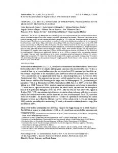
The maps in Fig. 1 built for mean monthly seaice concentration distributions for the 1969–2012 period show that the minimal extent of the area covered with sea ice drifting in the Arctic Ocean during the intra-annual cycle is typically observed in September. In this area, the boundary of the sea ice with maximum SIC along its perimeter tend to be outlying from the North Pole at varied distances, with the only anomaly of its advancing southward to 75° N occurred near the northern border of the Beaufort Sea. At other sites, this boundary is located almost exactly along 85° N, closely bordering the northern coast of Greenland and nearing the Queen Elizabeth islands. Ice massif is surrounded by belts of ice with SIC decreased from 80 to 10 %. Ice with SIC varying from 30 to 80 % is localized on the sea surface in the proximity of the Queen Elizabeth islands. At the northern borders of Baffin Island and near the Canadian Arctic archipelago, the concentration of sea ice is reported to be up to 50 %. The edge of sea ice with minimal SIC values extends from the Beaufort Sea to the western borders of the Chukchi Sea. Sea ice almost totally absent from the Bering Strait and in the area between 120 and 160° E long. in the coastal zone. Sea ice with SIC less than 20 % is observed in the East Siberian Sea, between 160 and 180° E long. Drifting ice with SIC about 10 % is encountered in the vicinity of Anjou and Lyakhovsky islands, while the Taimyr Peninsula is surrounded by ice with SIC ranging from 10 to 40 %. To the west of the peninsula, at some distance from Novaya Zemlya Island, sea ice floes extend towards the Franz Josef Land Archipelago, where ice with SIC up to 60 % have occupied the entire area. Farther north, the sea-ice belt contacts the northern boundary of the Svalbard archipelago and stretches in a continuous strip within a longitudinally pointed wedge (between 20 and 10° W at 80° N and between 20 and 25° W at 70° N) towards the coast of Greenland.
By October, the area covered by sea ice tends to expand, and sea ice with maximum SIC values is delineated in the sector from 120° W up to 170° E, passing closely by 75° N. In the sector from 170 to 150° E lat., ice with maximal SIC is localized in a belt between 75 and 80° N. In other areas of the Arctic Ocean, closely packed sea ice (SIC = 90 %) is located north of 80° N. The offshore area along Russia’s coastline stretching from Wrangel Island to the western coast of Taimyr Peninsula is covered by ice with SIC ranging from 50 to 70 %. In the Kara Sea, floating ice extends as far as 65° E with SIC ranging from 70 to 10 %. In the Barents Sea, the ice edge position has retreated to 77° N, at the same time, ice concentration is reported almost the same as in the Kara Sea. The Greenland Sea is dominated by ice with SIC between 60 and 90 %, while ice with lower SIC values is observed along its full perimeter. The northern coast of Greenland and the Queen Elizabeth islands are surrounded by very close ice. SIC ranges from 60 to 80 % within the area encompassing the Canadian Arctic Archipelago and the northern coast of Baffin Island. Between the western coast of Greenland and Baffin Island, ice concentration is between 10 and 40 %. Ice field attached to the shore in the sector from 120 to 160° W long. has SIC ranging from 30 to 50 %. The southern parts of the Chukchi Sea is almost completely ice-free. In the Bering Strait, sea ice with lowest levels of concentration is present only along coastlines of the continents. In November, sea ice with maximum SIC extends from Wrangel Island to the western coast of the Taimyr Peninsula and farther along 80° N lat. to the northeastern coast of Greenland. The area near the Queen Elizabeth islands and all but entire northern coast of Canada are also ice-bound by pack ice (100 % SIC). Completely covered with ice are the Kara and Chukchi seas where SIC varies greatly, from 10 to 90 %. In the Bering Strait, SIC does not exceed 20 %. The Sea of Baffin is covered by ice to the extent delimited by 70° N lat. where SIC is found to be varying from 10 to 90 %. In the Hudson Bay, sea ice was observed with SIC not greater than 50 %. By December, the sea-ice conditions become more complex in all the seas and bays of the Arctic Ocean whose most shores exhibit sea ice concentrations approximating maximum values. The only exception is the region between the Kara Strait and the Kola Peninsula, inclusive of the White Sea. In the Barents Sea, the southern boundary of ice has reached 75° N lat. North of Jan Mayen Island, the ice field that formed near the Greenland Sea expands into the northern regions of the Norwegian Sea. The Hudson Bay is covered by sea ice with SIC varying from 40 to 100 %. In the Bering Strait the degree of SIC is also reported to be high. In the north of the Bering Sea, its values lie in the 10–40 % interval. 79
A.E. BUKATOV ET AL.
Fig. 1. Intra-annual distribution of sea ice concentration (in percent) on the color scale, averaged for the period of 1969–2012. 1–12 – January–December.
80
SPATIAL AND TEMPORAL VARIABILITY OF THE ARCTIC SEA ICE DISTRIBUTION
In January, major changes appear to be taking place in areas that approximate the open ocean. The ice field propagation is delimited by 70° N. Ice drifting in the Central Arctic eventually forms almost continuous cover. In the marginal seas bordering the Atlantic sector, and in the Barents Sea, the areal extent of ice with SIC estimated at 10 to 60 % progressively increases. In the Baffin Sea, the area of open water is reduced at the expense of SIC increasing up to 60 %. The ice in the Hudson Bay has become very close ice (maximum SICs). Concomitantly, the Bering Sea area covered by sea ice with 80 % SIC has essentially increased. In February and March, a major rise in extent of the ice-covered areas is reported from the Greenland, Barents and Bering seas, as well as from the Davis Strait. Generally, the sea ice extent in the Northern Polar Region peaks in March. At this time, sea ice floating in the Bering Sea extends to the south reaching 55° N, and in the Barents Sea it moves towards the northern coast of Europe approaching 73° N. Sea ice with SIC up to 80 % covers the area between Novaya Zemlya Island and the Kola Peninsula. The Kara Sea is completely ice-covered. Open ice floating from the Greenland Sea reaches the Norwegian Sea and passes through the zero meridian. In the Baffin Sea, a continuous ice field is observed. The belt of coastal ice has expanded from the Davis Strait to Newfoundland. Beginning from April, the area covered by drifting sea ice begins to contract, which results in reduction of ice concentration on the open borders of the Arctic basin. Specifically, such processes are observed in the Bering Sea, from the Davis Strait to Newfoundland Island, and in proximity to the border between the Norwegian and Greenland Seas. In the meantime, the area covered by sea ice in the Barents Sea shows an increasing trend in the direction of the north-eastern border of Europe. In May, the area covered by ice continues to decline and so does the sea-ice concentration throughout the water surface area of the Arctic Basin. Thus, in the Bering Sea, SIC from 10 to 45 % is already reported, while in the Bering Strait SIC persists in the range from 55 to 75 %. In June, SIC however has gained 70 to 90 % within a stretch from the East Siberian Sea to the Kara Strait against the backdrop of generally shrinking ice field. Farther west, to 45° E long., SIC has reduced to be 20 %. The White Sea is reported to be already free of ice. Ice is also absent from the Bering Strait, but the sea water surface of the Chukchi Sea still remains ice-covered. Ice fields are experiencing degradation in the Beaufort Sea, although in some areas SIC exceeds 45 %. An appreciable decrease in SIC is observed in the Baffin Sea. In the north of the Norwegian Sea, sea ice has almost totally disappeared.
By July, sea ice concentration has essentially reduced, with ice extent varying from insignificant to non-existing in all marginal seas lying to the south of 70° N. To the north of this latitude, the extent of sea ice-covered area barely varies, however, sea ice concentration has decreased remarkably. SIC at least 80 % is reported from the areas in latitudes higher than 80° N. That same concentration is characteristic of the longitude sector between 130° W and 160° E (counter-clockwise) in the region lying north of 74° N. In the Hudson Bay, sea ice concentration does not exceed 30 %, while in the vicinity of the Canadian Arctic archipelago, some of sea ice with SIC 60 to 80 % has still survived. August is marked by a significant decline in the sea ice extent of the Barents and Kara Seas. In the Laptev Sea, ice concentration has decreased to 40 %, and down to 75 % along the northern border of the Beaufort Sea. Sea ice having SIC greater than 20 % fringe the Taimyr Peninsula, the northern coastline of Russia spanning from 165 to 180° E, and a stretch of Alaska coastline between 160 and 140° W. In the meantime, sea ice along the eastern, western and to a greater extent the northern borders of the Chukchi Sea displays lower SIC. The central part of the sea, including the Bering Strait, are completely free of ice. Concomitantly, the sea water areas bordering on the northern part of Greenland Island, and near the Queen Elizabeth Islands exhibit the presence of sea ice with high SIC, fringed by a strip of ice with low SIC. SEAICE EDGE DYNAMICS
The outer boundary of monthly average distributions of sea ice concentrations for the period from 1969 to 2012 shown in Fig. 1 delimits the position of ice edge, which depends on the ocean segment, rather than on the season alone. The most significant displacements of sea ice edge during the intra-annual cycle are observed west of Novaya Zemlya between 20 and 55° E, in the Bering Strait area. These areas are located in maritime zones bordering the open ocean. At about 42° E the sea ice edge can drift northward, as far as 82° N. Notably, the advancement of the ice edge that far north was not unprecedented in the history of the Arctic. In particular, the similar latitudinal location in August in the 18th century between Svalbard and Franz Josef Land is described in [FalkPetersen et al., 2004]. An important dynamic characteristic of the edge of drift ice is the velocity v of its displacement in the latitudinal direction. The diagrams in Fig. 2 illustrate longitudinal distribution of the intra-annual average monthly velocity of ice edge drift during the period of observation. The solid line delineates the velocity distribution, while thin lines indicate the limits of the 95 % confidence interval. Noteworthy is that the dynamics of sea-ice edge location shown in Fig. 2 does not include the region 81
A.E. BUKATOV ET AL.
Fig. 2. Distribution of intra-annual velocity (v) of the sea ice edge displacement in latitudinal direction along its perimeter, averaged for the period of 1969–2012.
82
SPATIAL AND TEMPORAL VARIABILITY OF THE ARCTIC SEA ICE DISTRIBUTION
lying between 21 and 126° W (clockwise) because of too complex configuration of the water surface area, given a great number of islands there. The diagrams show that the ice edge displacement velocity as a function of longitude is not monotonous. The diagrams have local extrema whose values are dictated primarily by the site longitude. The direction of seaice edge motion also changes within the intra-annual cycle, although in certain longitudinal sectors it remains immovable, in some months. In the period of ice formation occurring from September through March, the sea ice edge tends to move southward, whereas southward advancement of ice edge in September occurs almost along the entire perimeter. The exception in September is the vicinities of the Taimyr peninsula, where near 100° E sea ice edge velocity is found to be zero. In September, the fastest motion of the sea-ice edge southward is reported from the Kara Sea, where at about 71° E long. its velocity reaches a value of 31 km/day. In October, southward advancement of ice edge becomes intensified in the range between 21° W and 72° E and between 168° E and 150° W, with the velocity reaching 25 and 29 km/day, respectively. In other longitudinal sectors, sea ice reaches the coast and SIC increases. The longitudinal zones favorable for any significant edge displacement become narrower in the period from November through January. Any measurable ice edge dynamics persists only in the open sea areas close to the North Atlantic, as well as in the Bering Strait and the adjacent area of the Chukchi Sea. In November, a maximum value of velocity of the southward ice-edge motion is 30 km/day in the region spanning from 21° W to 60° E, and 20 km/day in the Bering Strait – the Chukchi Sea. These areas are featured by extrema in ice edge motion velocity values of 14 and 8 km/day in December, and 5 and 4 km/day, in January, respectively. In February, in the area lying approximately at 10° W to 36° E long. the direction of ice-edge progression remarkably changes from southern to northwardly, while the velocity does not exceed 3 km/day. At the same time, in the Bering Strait, the sea ice edge continues to move south at a rate about 2 km/day, whereas from March to almost August, it is already reported to be set in motion northwardly. In March, within a fairly appreciable stretch of the Barents Sea, the sea ice edge still progress, though slowly, southwardly. In April, in the 21° W to 54° E longitude range, the velocity of ice edge motion in some areas approximates the value of zero, while in other parts the ice edge has shifted to the north. In May, the rate of the ice edge motion southward intensifies, reaching 24 km/day in the Barents Sea, while the hitherto slight retreat of the sea ice edge to the north between 60 and 180° E long. becomes more discern-
ible. Little to no motion of the ice edge is reported between Greenland and the Svalbard archipelago. Beginning from June, the regions of sea ice edge drift northwardly tend to expand, with its velocity increasing. In July, the northward-directed sea ice edge displays a greatly magnified motion intensity along its entire perimeter. Particularly illustrative are the regions of the Barents and Kara Seas, the Laptev Sea, the Chukchi Sea and the Bering Strait. At the same time, the velocity minima in sea ice edge advancement to the north are documented between Greenland Island and the Svalbard archipelago, as well as near Taimyr Island. In August, the direction of ice edge displacement remains invariable, however, the velocity tends to slowdown, and in some areas the sea ice edge motion is arrested. The sea-ice edge with minimal velocity continues to expand northward into the Kara Sea, where in in proximity of 72° E its velocity reaches 23 km/day. To determine the most significant time cycles of the latitudinal displacement of the sea ice edge, a spectral density analysis of deviations of average monthly values of its location from its linear trend over the period from 1969 to 2012 was performed for every degree of longitude east of Greenland to the Beaufort Sea. The spectral density is estimated by the Fast Fourier Transform method using the Flat Top filter. The spectral density p distribution with frequency is shown in Fig. 3. The ordinate axis shows the cyclic frequency of oscillations f (1/year), while longitude of the sea ice edge position is plotted along the abscissa. A logarithmic color scale characterizes the spectral density distribution for each degree of longitude. It is shown that the main signal (the first harmonic) in the spectrum features oscillations with one cycle
Fig. 3. Distribution of spectral densities (p) of lateral displacement of sea ice edge in longitudinal direction. 83
A.E. BUKATOV ET AL.
Fig. 4. Longitudinal distribution of the linear trend values for ice edge displacement in latitudinal direction for the period of 1969–2012.
per year. This harmonic is present practically at all considered longitudes along the ice edge perimeter. The most remarkable absence of the signal is observed in the region located in the vicinity of the Taimyr Peninsula – the Severnaya Zemlya archipelago. The maximum spectral density oscillations are observed in the Barents Sea, where harmonics with two, three and four cycles per year are present in the oscillations spectrum. These are significantly weaker than annual and appear only in few longitude sectors. Low-frequency oscillations with a period of 2 to 5 years or more are established in some areas along the ice edge perimeter. In terms of longitude distribution, they fall in the spectral region with a prominent annual harmonic. The linear trend of latitudinal displacement of the sea ice edge over the period 1969–2012 was calculated for every degree of longitude east of Greenland to the Beaufort Sea. At this, the time series of average monthly latitude values were smoothed over 12 points by a sliding average in 1 month increments. The distribution of the linear trend along longitude is shown in Fig. 4 (thick line), while the thin lines delineate the 95 % confidence interval. The trend appears to be positive for most regions. The most significant trend values are observed in Greenland (0.08 degr/year) and the Barents (0.06 degr/year) seas, in the Chukchi Sea and the Bering Strait (0.06 degr/year). At the same time, there are areas of the Arctic basin where the trend shows negative values, specifically, for the Taimyr peninsula area and eastern part of the offshore Kara Sea. Some regions of the Laptev Sea and the East Siberian Sea may show both negative and positive trend, depending on which portion of the sea-ice edge perimeter lies within these areas. CONCLUSION
The intra-annual variability of regional distribution of ice in the Arctic basin was derived from the data on average monthly sea ice concentration for the 84
1969–2012 period, has been analyzed. The monthly displacement of the sea-ice edge positions in the latitudinal direction is investigated and the velocity of its displacement is estimated for every longitude degree along the perimeter of the sea-ice edge. The most intensive variability in the sea-ice edge position is observed in the Bering Strait, as well as in the Barents and Kara Seas areas, where the sea-ice edge displacement velocities within the intra-annual cycle are found to be greater than 20 km/day. A linear trend for latitudinal displacement of the sea-ice edge is calculated within the considered time interval, for every degree of longitude east of Greenland to the Beaufort Sea. The most significant value of the positive trend is reported for Greenland (0.08 degr/year) and Barents (0.06 degr/year) seas, as well as for the Chukchi Sea and Bering Strait (0.06 degr/year). The deviations cycle times have been calculated for average monthly values of the latitude degrees of the sea-ice edge position from its linear trend. It is established that the main signal in the spectral density distribution with frequency accounts for oscillations with one cycle per year. Oscillations with maximum spectral densities occur in the Barents Sea. In the oscillation spectrum, there are harmonics with two, three and four cycles per year, as well as lowfrequency oscillations with a period of two or more years. References Alexeev, G.V., Radionov, V.F., Alexandrov, E.I., et al., 2010. Climate changes in the Arctic and North polar regions. Probl. Arktiki i Antarktiki, No. 1 (84), 67–80. Baidin, A.V., Meleshko, V.P., 2014. The high and middle latitude atmosphere response to a decrease in sea ice extent and warming ocean surface temperatures. Meteorologia i Gidrologia, No. 6, 5–18. Cavalieri, D.J., Parkinson, C.L., Vinnikov, K.Y., 2003. 30-year satellite record reveals contrasting Arctic and Antarctic. Geophys. Res. Lett. 30 (18), 1970, p. CRY 4 1–2, doi: 10.1029/2003 GLO 18031.
SPATIAL AND TEMPORAL VARIABILITY OF THE ARCTIC SEA ICE DISTRIBUTION
Deser, C., Walsh, J.E., Timlin, M.S., 2000. Arctic sea ice variability in the context of recent atmospheric circulation trends. J. Climate 13 (3), 617–633. Dmitriev, V.G., Kovalevskii, D.V., Alexeev, V.A., Bobylev, L.P., 2012. To risk assessment of adverse hydrometeorological phenomena and climate anomalies in the Arctic. Probl. Arktiki i Antarktiki, No. 4 (94), 52–62. Doronin, Yu.P., 1974. Effects of sea ice cover on the atmosphereocean heat exchange. Probl. Arktiki i Antarktiki, Iss. 43–44, 52–60. Eremeev, V.N., Bukatov, A.E., Bukatov, A.A., Babiy, M.V., 2013. Interannual variability of the atmosphere-ocean heat exchange in the Antarctic. Dokl. Nats. Academii nauk Ukrainy, No. 1, 96–104. Falk-Petersen, S., Wold, A., Rostad, A., et al., 2004. Intense feeding of Calanus hyperboreus on Arctic Autumn Bloom propagated by a Record Minimum Sea Ice Extent in 2004, in: The ACIA Intern. Sci. Symposium on Climate Change in the Arctic. Reykjavik, Iceland, Nov. 9–12, pp. 1–4. Frolov, I.E., Gudkovich, Z.M., Karklin, V.P., Smolyanitskii, E.M., 2010. The Arctic and Antarctic climate variability driven
by natural causes. Probl. Arktiki i Antarktiki, No. 2 (85), 52–61. Gudkovich, Z.M., Karklin, V.P., Kovalev, E.G., et al., 2008. Impact from polar vortex evolution on variations in sea ice cover extent and other components of the Arctic and Antarctic climate systems. Probl. Arktiki i Antarktiki, No. 1 (78), 48–57. Khon, V.Ch., Mokhov, V.I., 2010. Climate changes in the Arctic and potential conditions for Arctic maritime shipping in the 21st century. Izv. RAN, Ser. FAO, 46 (41), 19–25. Matishev, G.G., 2008. Impacts from climatic and ice regimes variability on maritime shipping operations. Vestn. RAN 78 (10), 896–902. Smirnov, A.V., Koroblev, A.A., 2010. Interrelation between mixed layer properties and heat fluxes at the ocean-atmosphere interface in the North-European basin. Probl. Arktiki i Antarktiki, No. 3 (86), 79–88. http://badc.nerc.ac.ukldata/hadisst/ (submittal date: 30.10.2003). http://nomad1.ncep.noaa.gov (submittal date: 20.05.2013). Received October 13, 2015
85