ridge west of the Dry Tortugas, named "Howell Hook" by Jordan & Stewart. (1959). .... of some 130 banks on the northwestern gulf compiled by Parker & Curray.
BULLETIN VOLUME
20
OF MARINE SCIENCE 1970
NUMBER
3
MORPHOLOGY AND QUATERNARY HISTORY OF THE CONTINENTAL SHELF OF THE GULF COAST OF THE UNITED STATES1 ROBERT D. BALLARD2 Office of Naval Research, Boston Branch Office, Boston, Massachusetts AND
ELAZAR UCHUPI Woods Hole Oceanographic Institution, Woods Hole, Massachusetts ABSTRACT
Sea-level fluctuations of the Quaternary have greatly influenced the surface morphology of the continental shelf off the gulf coast of the United States. Two prominent shorelines, at 60- and 160-meter depths, and other features found on the gulf shelf can be related to the relatively recent events of the Quaternary, particularly those of the Holocene transgression. Landward of the 40-meter contour, the slow rise of the sea surface and modern sedimentation have produced a complex mixture of topographic expressions. Diapiric structures, which are abundant from De Soto Canyon westward, appear to be of secondary importance in contributing to the shelf's surface relief. INTRODUCTION
To understand better the morphology of the continental shelf off the gulf coast of the United States, a detailed bathymetric chart was made of the region (Plate I). The information used in constructing this chart is based upon soundings taken by the U. S. Coast and Geodetic Survey during its hydrographic surveys of the past three decades. This map and the work of previous investigators indicate that the transgression and regression of the sea in response to the Pleistocene glacial epochs have played an important role in shaping the morphology of the region. The major features on the shelf's surface are divisible into three zones parallel to the coast; the first two represent relict shorelines of this outer and middle shelf and the third depicts a modern and relict province of the inner shelf. The morphologies of these three zones are described and an attempt is made 1
2
Contribution No. 2399 from the Woods Hole Oceanographic Institution. Present address: Woods Hole Oceanographic Institution, Woods Hole, Massachusetts 02543.
548
[20(3)
Bulletin of Marine Science
to explain their origin and relationship to the eustatic sea-level events of the late Quaternary. MORPHOLOGICAL
REGIONS
OF THE
SHELF
The 160-Meter Region of the Outer Shelf.-One of the more significant topographic expressions along the 160-meter contour is a large arcuate ridge west of the Dry Tortugas, named "Howell Hook" by Jordan & Stewart (1959). This ridge extends northward for at least 80 km in water depths of 140 to 160 meters. On the landward side of the ridge, between the 140- and 76-meter contours, is a complex pattern of closely spaced ridges and valleys which are perpendicular to the contours. These ridge and valley units grade into a large depression on the east flank of Howell Hook. This sloping depression flattens into a broad platform. Dredge samples and fathograms taken over this fiat platform by Jordan & Stewart (1959) revealed isolated coral pinnacles and irregular depressions producing a honeycombed topography. Seaward of this platform and to the north is a series of sinuous submarine channels with their headward expressions originating at the 160-meter contour. Projections similar to Howell Hook also occur farther north along the 160-meter contour, but their trends are to the south. Reef patches, isolated pinnacles, and domelike rises have also been noted off these projections (Jordan & Stewart, 1959). Off the central gulf coast, modern deltaic sedimentation and downwarping have covered the shelf's surface, leaving only the rounded outlines of the Mississippi Trough and De Soto Canyon. Information gathered from borings and offshore cores indicates, however, the presence of an entrenched river valley system associated with the Mississippi River, smaller erosional valleys, and a soil profile buried beneath this modern sedimentary blanket (Fisk & McFarlan, 1955). Once the modern sediments are removed and the effects of downwarping taken into consideration, these features and their associated erosional surface are concentrated about the 140- to 160-meter depth zone. To the west, where modern sedimentation and downwarping have been slow, numerous preserved channels dissect the outer shelf and upper Continental Slope (Plate 1). The trends of these channels appear to be controlled by intrusive bodies which form distinctive hills (Shepard, 1937). The 60-Meter Region of the Middle Shelf.-The major break in the shelf of the gulf region occurs landward of the 160-meter contour at an average depth of 130 meters. Other than this break in slope and a small ridgeand-valley complex off Tampa, Florida, few features are evident within this depth zone of the outer shelf. The next concentration of topographic features occurs landward of the shelf break at the 60-meter contour, the most striking of which is a series
1970]
o
Continental
Shelf of the Gulf Coast
~
50
~ ~
100
~
15
549 60
....• ....•
.....
"-
~
~ ~
Ballard & Uchupi:
"-
, , \
"""-
.....
.....
.....
••..••..
---
200
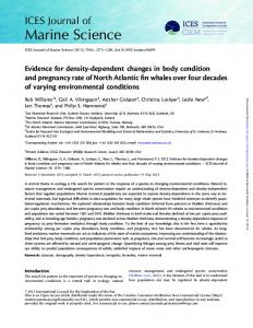
1. Generalized sea-level curve for the Gulf of Mexico based upon work by Curray (1965), Milliman & Emery (1968), and Scholl, Craighead & Stuvier (1969). Dashed lines are inferred, whereas solid line is based upon radiocarbon dates.
FIGURE
of six major ridge-and-valley complexes running from Cape San BIas south to a broad plateau west of the Dry Tortugas (Plate 1). These ridges and valleys are regularly spaced and trend diagonally to the present shoreline. Their lateral extent is not restricted to the 60-meter contour, as they range up to 80 km in length and extend between the 50- and 70-meter contours. The ridges are similar to those along the 160-meter contour, and subtle trends in the bathymetry indicate that these similar structures may in fact be connected. An abrupt change in slope coincides with the 60-meter contour. The average bottom declivity shoreward of 60 meters is 0.5 meter per km, whereas the slope from 60 to 180 meters is approximately 2.0 meters per km (Gould & Stewart, 1955). Jordan & Stewart (1959) also noted that eastward from Howell Hook a break in slope occurs at 60 meters, with a smooth ramp seaward and an irregular terrace landward. Curray (1960) noted similar ridge-and-valley complexes along the 60meter contour off Galveston, Texas, which had both west and east diagonal trends (Plate 1). West of Cape San BIas, two projections in the 60-meter contour have the same apparent form as the cuspate shoreline of the present cape. There is also a distinctive series of bulges along the 60-meter contour from Cape San BIas west to the Rio Grande (Plate 1). They are expressed as semicircles pointing seaward and are located off all the major river systems of the gulf coast. Between the 60- and 40-meter contours are remnants of a complex valley system which runs down the shelf and terminates at the 60-meter contour. Three areas, off Tampa Bay, Panama City, and Galveston, have concentrations of these detritic patterns (Fig. 2), and are related to zones
550
Bulletin of Marine Science
[20(3)
of the shelf where modern sedimentation and reworking have not buried or obscured their surface expression. Nearshore Province of the Inner Shelf.-Seaward of Florida Bay and north to Cape San BIas, an intricate topography is evident inshore of the 40-meter contour (Plate 1). The bottom in this area is highly irregular, with no obvious surface patterns. Despite its complexity, however, few features are noted with any appreciable relief, Florida Middle Ground being the only exception (Jordan, 1952). One of the surprising features of this shelf zone is the apparent lack of large depressions commonly associated with the southern Florida platform, as reported by previous investigators (Jordan, 1954; Jordan & Stewart, 1961; Jordan, Malloy, & Kofoed, 1964). Off Cape San BIas, a cuspate foreland extends for 100 km along the coast and 60 km offshore to the 60-meter contour. Within this zone are sand shoals typical of other cuspate forelands, such as off Cape Hatteras and Cape Canaveral (Shepard, 1960b). The Cape San BIas cuspate foreland consists of two ridge series with the northern being the better developed. Within the northern ridge region are two groups of smaller ridges oriented at right angles to one another. Intermixed with the southern ridge series are numerous depressions, and what resembles a spit-and-Iagoonal complex located along the 32-meter contour. Southeast from Mobile, a group of features resembling an ancient bay, barrier island, and lagoon can also be seen along the 32-meter contour. The Mississippi Delta region, the largest modern depositional province of the gulf coast shelf, has been extensively studied by numerous investigators (Fisk, 1955; Fisk & McFarlan, 1955; Fisk, McFarlan, Kolb & Wilbert, 1954; Shepard, 1955, 1960a). The active portion of this delta has built out across the shelf some 150 km. On the delta's east and west flanks, the distributaries release their load upon the shallow shelf, while, off the central section, sediments are being discharged directly on the continental slope, forming the large submarine Mississippi Cone. An interesting feature of the central section is the alternating valley and ridge topography of the delta front. The valleys are small, one-half to one km across, with depths ranging up to 30 meters, and lengths of 3 to 6 km. The highly irregular surface off Mobile reappears west of the Mississippi Delta between 92° and 95°W. In this area, which has received little sediment in modern times, are several ridges and channels trending in both easterly and westerly directions. Southwest from 95°W to the Rio Grande, a moderate supply of sediments to the shelf has produced a smooth, gently sloping surface (Curray, 1964). A series of ridge-and-valley structures are present, however, just north of the Rio Grande delta in 20 and 28 meters of water. They occur
1970]
Ballard & Uchupi: Continental Shelf of the Gulf Coast
551
as isolated ridge-and-valley units with the marked appearance of a spit and associated lagoon, and as clusters extending at approximately 60° to the shoreline; the latter forms have widths of 100-300 meters (Mattison, 1948). QUATERNARY
HISTORY
OF THE
GULF
The ongms of the three morphologic zones of the outer, middle, and inner shelf appear to be related to sea-level fluctuations of the Quaternary. Figure 1 is a composite of three curves for sea level published by Curray (1965), Milliman & Emery (1968), and Scholl, Craighead & Stuvier ( 1969). The stillstands which occurred during the late Quaternary lead to the development of the three relict shoreline provinces now seen on the shelf. The 160-Meter Shoreline of the Outer Shelf.-The deepest and apparently oldest shoreline preserved on the outer shelf occurs near the 160-meter contour, with Howell Hook and the smaller spit-and-Iagoon complexes to the north indicating its position (Fig. 2). As the sea stood at this position, sand moving in the littoral zone shaped these features, with the spit barriers pointing in the direction of longshore drift. The north trend of Howell Hook opposing the south trends of the lesser spits implies that a convergence or rip in the littoral circulation pattern occurred just north of Howell Hook. Sand deflected seaward by this rip formed submarine channels with their heads originating in the then shallow waters near the present 180-meter contour. Off the Texas coast, where remnants of this shoreline are preserved, the rapid increase in water depth evidently prevented this lateral movement of sand, with the rivers discharging their sediment loads directly upon the upper Continental Slope. This direct deposition is reflected in the absence of sand-barrier features along the 160-meter contour off the Texas coast. The position of the Mississippi Trough off the central region of the shelf further indicates the existence of an ancient shoreline near the 160-meter contour. The presence of this canyon, buried stream valleys across the shelf, and a soil profile covering the erosional surface formed during this stillstand were found to be associated with a sea level lowering of 140 to 160 meters (Fisk & McFarlan, 1955). When the sea stood at 160 meters, the Mississippi River entered the gulf through this trough and built a large submarine cone on the outer continental slope, whereas the courses of the lesser rivers terminated at the 160-meter shoreline. Coral reefs, isolated coral pinnacles, and domelike rises which flourished at the time when sea level was located near the 160-meter contour are located along the entire length of the southwestern Florida platform in water depths of 180 meters (Jordan & Stewart, 1959).
552
Bulletin of Marine Science
[20(3)
The period at which this shoreline was formed remains unknown. Based upon work by Curray (1965), Milliman & Emery (1968), and Lemke, Laird, Tipton & Lindvall (1965), two periods appear as possible points at which such a maximum lowering of the sea may have occurred (Fig. 1). The first was during the Farmdale glacial epoch some 40,000 to 70,000 years B.P. when the greatest advance of ice of the Wisconsin occurred on the North American continent (Lemke, Laird, Tipton & Lindvall, 1965). The other period was just prior to the Holocene transgression approximately 15,000 years B.P. when a lowering of 130 meters probably occurred (Milliman & Emery, 1968). The 60-Meter Shoreline of the Middle Shelf.-The events of the Holocene transgression from approximately 14,000 to 8,000 years B.P. appear to have had a pronounced effect upon the morphology of the outer and middle shelf of the gulf (Curray, 1960). Several lines of evidence indicate that during this general transgression of the shoreline a series of events occurred which resulted in the formation of prominent shoreline features between 40 and 70 meters (Fig. 2). The drainage patterns of the coastal plain that formed when the shoreline was at the 60-meter contour, the spit-and-Iagoon complexes south of Cape San BIas, the cuspate foreland which persists today as Cape San BIas, and the deltaic bulges associated with the major rivers flowing into the gulf are the most prominent features of the 60-meter shoreline. Work by Parker & Curray (1956), Ludwick & Walton (1957), and Gould & Stewart (1955) on calcareous provinces of the gulf coast shelf further indicate an interruption of the Holocene transgression. A histogram of some 130 banks on the northwestern gulf compiled by Parker & Curray (1956) shows the presence of three zones at 18, 55, and 82 meters of coral growth. Ludwick & Walton (1957) found similar coral zones in the northeastern gulf, and the work by Gould & Stewart (1955) demonstrates the existence of oolitic and algal sands at 50-70 meter depths off central Florida. Ludwick & Walton (1957) advanced a four-stage theory to explain the development of these reefs, which is presented below in a slightly modified form. Stage 1: The first stage or pre-reef stage occurred when sea level was at the Howell Hook shoreline. The shelf was exposed, with streams and rivers depositing a layer of sand containing yellow-brown, coarse sand and gravel. This layer of sand occurs on both sides of the reefs and is thought to be continuous beneath it, forming the base on which reef growth began. Stage 2: Major growth of the reef then began on this sandy surface as sea level rose and paused about the 60-meter shoreline. Such conditions would place the shoreline about 15 km landward of the reef, with active
1970]
Ballard & Uchupi:
Continental Shelf of the Gulf Coast i;
'"
0
'"
'~"_S'-t"
~-:'~
\~
~'" :\0
,,~y
enCI)
. ~-l
.'-
:::
~
.,.
\,0
-",~
0
N CI)
.S
v•....
0
..c:
'"•.... CI)
Q)
E 0 \0 "0
::: o::l
0 \0 ,...., CI)
;:
-'"'"
-5 -5
.~
0
:;; "0
CI)
"c;j
'u0
0
2
'"'"o::l CI) '" •....
o~ zq q~
0 0
iQ~ We
;:l
~~ ~ ~s: ~~ ~ -~ ~w
"c;j
~U
CI) 4-;
W W
N
't r~~
-'"
e 0
.~ ..c: c.. •.... 0
E 0 CI)
0 N >LI a: :J