Bulletin of the Geological Society of Greece
Vol. 40, 2007
Assessment of hydrocarbons subsoil and groundwater pollution in a refinery occupied property at the old industrial zone of Athens Pireaus, Greece Zotiadis V. Edafomichaniki S.A. Kollios A. Edafomichaniki S.A. http://dx.doi.org/10.12681/bgsg.16995
Copyright © 2018 V. Zotiadis, A. Kollios
To cite this article:
Zotiadis, V., & Kollios, A. (2018). Assessment of hydrocarbons subsoil and groundwater pollution in a refinery occupied property at the old industrial zone of Athens - Pireaus, Greece. Bulletin of the Geological Society of Greece, 40(3), 1505-1512. doi:http://dx.doi.org/10.12681/bgsg.16995
http://epublishing.ekt.gr | e-Publisher: EKT | Downloaded at 05/06/2018 20:39:19 |
Δελτίο της Ελληνικής Γεωλογικής Εταιρίας τομ. ΧΧΧΧ, 2007 ου Πρακτικά 11 Διεθνούς Συνεδρίου, Αθήνα, Μάιος 2007
Bulletin of the Geological Society of Greece vol. XXXX, 2007 Proceedings of the 11 t h International Congress, Athens, May, 2007
ASSESSMENT OF HYDROCARBONS SUBSOIL AND GROUNDWATER POLLUTION IN A REFINERY OCCUPIED PROPERTY AT THE OLD INDUSTRIAL ZONE OF ATHENS PIREAUS, GREECE Zotiadis V.1, and Kollios A.1 1
Edafomichaniki S.A., Em. Papadaki 19, N. Iraklio 141 21, Athens,
[email protected],
[email protected]
Abstract Industrial activities that took place in the old industrial zone of Athens-Piraeus widespread pollution in natural systems. This specific environmental site assessment presents subsoil and groundwater pollution data by petroleum hydrocarbons in a property occupied by a small scale refinery the last 50 years. Additionally the verti cal distribution and horizontal variability of pollution is analysed as a result of sev eral point sources existence such as underground storage tanL·. Environmental sur vey site works conducted by boreholes performance and installation of stand-pipe type piezometers for groundwater monitoring. Totally 32 soil core samples were analyzed for total petroleum hydrocarbons and additionally 4 soil core sub-samples where volatile organic compounds maximum values were recorded, analyzed for aromatic hydrocarbons. Petroleum hydrocarbons values in subsoil and groundwater range from 310 to 8130 mgKg1 and 0.6 to 2550 mg/l respectively. This paper pro vides hydrocarbons pollution data of the site and demonstrates the needfor an envi ronmental site assessment study before any investment and development action takes place in brownfield's areas. Key words: TPH, PAHs, mineral oils, contamination.
Περίληψη Η βιομηχανική δραστηριότητα που αναπτύχθηκε στην παλαιά βιομηχανική ζώνη Αθή νας - Πειραιά δημιούργησε εκτεταμένα προβλήματα περιβαλλοντικής υποβάθμισης των φυσικών συστημάτων. Η παρούσα περιβαλλοντική έρευνα παρουσιάζει στοιχεία ρύπανσης του υπεδάφους και του υπόγειου νερού από πετρελαϊκούς υδρογονάνθρακες σε μία ιδιοκτησία έκτασης 19 στρεμμάτων από τη λειτουργία εγκατεστημένης μονάδας παραγωγής ορυκτέλαιων τα τελευταία 50 χρόνια. Παράλληλα αναλύεται η οριζόντια και κατακόρυφη κατανομή της ρύπανσης από υδρογονάνθρακες στο υπέδαφος σε ένα ανομοιογενές πεδίο λόγω της παρουσίας σημαντικών σημειακών πηγών ρύπανσης, όπως οι υπόγειες δεξαμενές αποθήκευσης. Η περιβαλλοντική έρευνα πραγματοποιή θηκε με την εκτέλεση δειγματοληπτικών γεωτρήσεων και την εγκατάσταση πιεζόμετρων ανοικτού τύπου για την παρακολούθηση των ποιοτικών χαρακτηριστικών του υπόγειου νερού. Συνολικά 32 εδαφικά δείγματα από πυρήνες αναλύθηκαν για πετρε λαϊκούς υδρογονάνθρακες ενώ 4 αντιδείγματα στα οποία είχαν καταγραφεί οι υψηλό τερες συγκεντρώσεις πτητικών οργανικών ενώσεων αναλύθηκαν για αρωματικούς υ-
- 1505-
http://epublishing.ekt.gr | e-Publisher: EKT | Downloaded at 05/06/2018 20:39:19 |
δρογονάνθρακες. Προσδιορίσθηκαν συγκεντρώσεις πετρελαϊκών υδρογονανθράκων στο υπέδαφος από 310 έως 8130 mgKg'1 και στο υπόγειο νερό από 0.6 έως 2550 mg/l. Η παρουσίαση από την παρούσα εργασία της έκτασης του προβλήματος ρύπαν σης από υδρογονάνθρακες στην περιοχή έρευνας υποδεικνύει την αναγκαιότητα εκτέ λεσης περιβαλλοντικής αναγνώρισης για την καταγραφή ενδεχόμενης ρύπανσης σε πα λαιές βιομηχανικές περιοχές πριν την ανάπτυξη επενδυτικής δραστηριότητας και την αλλαγή της χρήσης γης. Λέξεις κλειδιά: Πετρελαϊκοί, αρωματικοί υδρογονάνθρακες, ορυκτέλαια, ρύπανση.
1. Introduction Remediation and development of contaminated land demands thorough understanding of the nature and extent of soil contamination, i.e. determination of key- contaminants and their mobility/toxicity, as well as delineation of vertical and horizontal spatial distribution of contamination. Thus, environmental surveys prior to development actions should be a common practice in brownfield's areas. This paper presents the findings of such an investigation at an urban site within the old industrial zone of Athens - Piraeus, Greece. This particular Environmental Site Assessment Phase II study was performed in parallel with a geotechnical study within an area of 19000 m2 which was occupied by a small scale refinery over the past 50 years. An Environmental Site Assessment Phase I study was previously conducted to identify Recognized Environmental Conditions, as defined by the American Society for Testing and Materials Standard E 1527 - 05 and presented the Environmental Risks at the site from the past refinery operation. According to the topographical layout of the refinery the main sections during production included several Underground Storage Tanks (USTs) of raw materials (petroleum, solvents, furfuraldehyde) and products (minerals oils, paraffin's and asphalt), distillation unit, chimneys, chemical and office buildings, washing and paint operations unit, warehouses, internal sewage system and other secondary buildings (machinery, workers changing rooms, etc). Nowadays a new land use was planned for the site with the development of a commercial centre building with two basements. The objectives of the geochemical study were to assess the level of soil and groundwater organic pollution by hydrocarbons, as well as vertical distribution and horizontal variability of pollution at different depth horizons within the site before development.
2. Geology - Stratigraphy The geology of the area comprises Quaternary and Neogene sediments in increasing geological age(IGME 1986): •
Holocene formations: alluvial deposits (sands, clays, gravels) in intercalations with loose conglomerate.
•
Pleistocene formations: Fluvial deposits, conglomerate in intercalations with thin horizons of breccias, mudstones, sandstones and sandy marls.
The stratigraphy of the area was investigated by performance of four boreholes with codes Gl to G4 till the depth of 30 m and the simplified geotechnical model comprises the following layers: •
LAYER I: Man made deposits
•
LAYER II: Silt, silty clay with sand to lean clay (ML) (ML-CL) (CL).
•
LAYER III: Silt, silty sand to sandy silt (ML) (SM-ML).
•
LAYER IV: Clay (CL).
•
LAYER V: Silty-clayey gravel, clayey sand to silty sand (GM-GC) (SC) (SM).
- 1506-
http://epublishing.ekt.gr | e-Publisher: EKT | Downloaded at 05/06/2018 20:39:19 |
Hydrogeological monitoring during a two years period revealed that groundwater level is found between depth 5.80 m to 6.10 m with a low hydraulic gradient of about 2 % (similar to the site morphology) with a NNW - SSE direction.
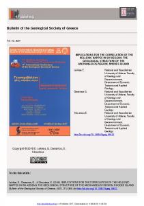
3. Materials and methods A total of 32 soil core samples were collected from the studied site. Eight boreholes with codes CI to C8 reaching a maximum investigation depth of 10.50 m were drilled inside the field following the specifications of USEPA 1996b at locations as shown in Figure 1. During site works Volatile Organic Compounds (VOCs) were measured in core samples at every single meter of penetration using a Photo Ionization Detector. Stand-type piezometers were installed at performed boreholes for groundwater level and quality monitoring. From each borehole, soil core samples were collected from four horizons (A, B, C, D) at depths of A = 3 m, Β = 5 m, C = 7 m and D = 9 m by mixing the material from 10 cm above and below the specific depth to produce the bulk sample. Sampling depths were selected on a basis of soil material differentiation according to geotechnical data and the design of the environmental site investigation (EPA/240/R-02/005).
4 G2
TOPOGRAPHICAL LAYOUT WITH BOREHOLE LOCATIONS SCALE
+
GEOTECHNICAL BOREHOLES
j,
ENVIRONMENTAL BOREHOLES
Figure 1 - Map of the sampling area showing locations of the performed geotechnical and environmental boreholes The core samples were collected using stainless steel equipment, stored in jars of 500 ml volume and preserved on site in portable refrigerator up to their transportation to the laboratory. All chemical analysis were performed at an accredited by ESYD laboratory in Athens, Greece. Thirty two soil core samples were analyzed for Total Petroleum Hydrocarbons (TPH) using Gas Chromatography according to EPA 8015b method (USEPA 1986a). Additionally, four core subsamples were selected on a basis of higher recorded VOCs values and analyzed for Poly cyclic Aromatic Hydrocarbons (PAHs) using Gas Chromatography according to EPA 8100 method (USEPA 1986a). Analytical precision was assessed by using analytical duplicate samples and was reported to be better than ± 3 %.
- 1507-
http://epublishing.ekt.gr | e-Publisher: EKT | Downloaded at 05/06/2018 20:39:19 |
Water samples were also collected according to ASTM D 4448-85a specification using standard Teflon bailers, lit capacity from the groundwater monitors. The samples were analyzed for Total Petroleum Hydrocarbons using Gas Chromatography according to EPA 8015b method and SW846 specifications (USEPA 1986a).
4. Results and discussion 4.1. Volatile Organic Compounds (VOCs) The Volatile Organic Compounds values in core samples (n=80) range from 0 to 23 ppm. Low VOCs values is a result of potential biodégradation, volatilization or migration of volatile organic compounds and express the nature of contamination from heavy hydrocarbon fractions at the area.
4.2. Polycyclic Aromatics Hydrocarbons (PAHs) The analytical results of PAHs values in four selected core samples where VOCs maximum values were recorded, are presented in Table 1. Table 1 - Analytical results of PAHs concentrations in selected cores samples
Chemical compound
Borehole C3
Borehole C5
Borehole CI
Borehole C7
Horizon C
Horizon D
Horizon D
Horizon A
mgKg
1
1
mgKg'
1
mgKg"
mgKg"1
TPH PAH (sum 11) Anthracene Fluoranthene Pvrene Benzo( 1,2)anthracene Chrvsene Benzo(3,4)fluranthene Benzo( 11,12)fluranthene
3860 < 1,604 0,012 0,009 0.163 0,850 0.450 0,060