Cloud-based GNSS Processing of Distributed Receivers of Opportunity: Techniques, Applications and Data-collection Strategies J. A. García-Molina(1,2) and J. M. Parro(3) (1) HE Space for European Space Agency (ESA/ESTEC), The Netherlands (2) Universitat Politècnica de Catalunya (UPC), Spain (3) Vitrociset for ESA/ESTEC, The Netherlands email:
[email protected] Abstract—This paper discusses some of the applications and techniques boosted by the Cloud-GNSS framework, focusing on the exploitation of distributed receivers of opportunity (RoO) located in close-by locations. While the Cloud-GNSS concept has already been demonstrated to be technically feasible, the maturity of the concept in terms of applications and signal processing techniques is still relatively low. In particular, the collaborative processing of distributed RoOs is a promising research area that might play an important role in the near future to solve some of the limitations faced by current GNSS receivers in harsh propagation conditions (e.g., urban and indoor conditions) or in the presence of jamming and spoofing attacks. Index Terms—Cloud, GNSS, Cloud-GNSS, receiver of opportunity, distributed receivers, collaborative, collaborative Cloud-GNSS, fading, jamming, spoofing.
I. INTRODUCTION
N
ew applications and services are being discussed in the GNSS field thanks to the fast evolution of commercial Cloud platforms [1]-[3], the Internet of Things (IoT) [4] and the future 5G standards [5]. Storage and processing of data can already be handled on demand in the Cloud, devices are expected to be increasingly connected to the Internet, and 5G will bring higher data rates and lower latencies than current 4G Long Term Evolution (LTE). Thus, the full exploitation in the Cloud of GNSS signal snapshots and other sensors’ observables gathered by devices connected to the Internet is not only a priori a feasible approach, but a very interesting opportunity for making possible and/or boosting new applications, services and use cases. The role of the Cloud in the processing of those signal snapshots and/or observables highly depends on the application targeted and on the benefit expected [6]-[10]. In some cases, the Cloud might be used as the platform where to merge and exploit the data and GNSS observables already estimated by the receiver. In other cases, the Cloud is expected to host the full processing of the GNSS signals, offloading the local device from the acquisition, tracking and positioning processes. In both cases, a benefit in terms of cost, power consumption, computational burden and/or performance might
Date of current version: November 2017
be targeted, depending on the specific application or use case. And, also in both cases, Cloud processing will allow the access to additional data that can support or assist the processing performed (from GNSS assistance data [11] to more complex products generated based on crowdsourced data or signals [12]). Apart from the existing positioning and navigation applications and services for which benefits are expected to be achieved when migrated to the Cloud, we can find other applications and services that are only possible with the collaborative, cooperative or crowdsourced processing of multiple distributed devices’ data and signals, being the devices exploited as receivers of opportunity (RoO). Among those applications, we can think about the generation of radio and magnetic fingerprint maps [13], [14], the application of advanced cooperative and collaborative positioning techniques relying on the signals and observables from multiple devices [15], or the detection and localization of interference sources, jammers [16] and spoofers, just to name a few. The range of sensors, signals and data that can be exploited in this kind of application is very broad and completely open. Indeed, apart from the GNSS signals and observables, almost any RF signal received and any sensor integrated in the device can be of interest. This paper discusses some of the applications and techniques boosted by the Cloud-GNSS framework, focusing on those based on the exploitation of distributed receivers of opportunity located in close-by positions. II. THE CLOUD-GNSS FRAMEWORK Cloud-GNSS is a very broad concept: any processing offloaded from the GNSS receiver’s chipset to the Cloud can be considered as part of this framework. Cloud-GNSS can be seen as one more extension of software-defined radio (SDR) receivers [17], with the instances where the SDR receivers are running being implemented somewhere in the Cloud (instead of a local platform). Indeed, thanks to the fast evolution of commercial platforms, the place where the processing actually takes place is relatively transparent to the processing techniques or applications being implemented. The main
differences introduced are the flexibility to use the computational resources required (being available at a cost), the availability of additional assistance data, and the access to signals and data gathered by multiple receivers. The later opens the door to new techniques and applications that cannot be covered by conventional on-chip positioning solutions. The migration of the GNSS processing to the Cloud can be performed at different levels, depending on the benefits expected and the applications targeted. In IoT applications, where power consumption and cost are critical factors, we might be interested in performing the full GNSS processing in the Cloud based on signal snapshots gathered by the receiver. This allows to limit the functionality of the local receiver to the reception, down-conversion and digitization of the RF signals, and the later transmition of the resulting signal snapshots to the Cloud with a given duty cycle. In other cases, we could be interested in keeping the acquisition and tracking operations in the local receiver, transmitting to the Cloud only the GNSS observables. This approach enables the application of advanced and precise positioning solutions in the Cloud (where advanced positioning products might be available), while limits the amount of data transmitted by the receiver. Fig. 1 illustrates the snapshot- and observables-based CloudGNSS receiver alternatives. The migration of the positioning process to the Cloud can be extended to the exploitation of signals of opportunity and sensors’ measurements, as illustrated in Fig. 2, in order to implement complex hybrid positioning solutions. Depending on the number of signals and sensors exploited, the computational burden of the solution might be too high to be implemented in the local device. Indeed, among the SoO of potential interest for positioning purposes we can find multiple terrestrial communication signals like WiFi, Bluetooth, Nearfield communication (NFC), cellular communication systems like 3G or 4G LTE [18], future 5G, etc. Additionally, almost any sensor available in the device might be exploited for positioning purposes, including inertial sensors (accelerometers, gyroscopes), magnetometers, barometers, microphones, cameras, etc. The implementation of these hybrid solutions in the Cloud might also be desirable in order to include in the positioning solution not only the signals and data retrieved by the devices, but also complex assistance or support data accessible by the Cloud (e.g., precise 2D/3D maps [19], [20]) or generated based on the crowdsourced signals and data from multiple devices in close-by locations (e.g., radio and magnetic fingerprint maps [13], [14]). The implementation of this data fusion process in the Cloud might allow to manage efficiently the big volume of data (potentially real-time data) exploited in the positioning solution. Besides the access to complex products, assistance data and theoretically unlimited computational resources, the Cloud might provide as well the means to exploit encrypted and protected GNSS signals for which specific security modules would be in principle required by the local receiver. This could allow the provision of at least
Date of current version: November 2017
Fig. 1. Illustration of the Cloud-GNSS receiver concept.
Fig. 2. Illustration of the cloud-based hybrid positioning concept. some of the services associated to those signals to a wider number of users (e.g., position authentication), while reducing the cost and computational burden at receiver level. Or could just enable the exploitation of those signals as additional signals of opportunity (i.e., not necessarily accessing the original services provided). The availability of different signals and measurements form multiple devices in close-by locations opens the door to a plethora of new techniques and applications. For example, the devices can be treated as receivers of opportunity in order to perform a collaborative processing jointly exploiting the signals and data from all the RoOs distributed in a given area, as illustrated in Fig. 3. Thus, the typical cooperative positioning approach [15] can be extended to include as well the exploitation of signal snapshots (including GNSS and terrestrial SoO) and additional products generated in the Cloud based on data from previous epochs, as mentioned earlier. Among the possible collaborative applications, we can find those targeting the improved performance and availability in harsh propagation conditions, or better resilience to jamming
with a certain accuracy by each receiver, being 𝑡𝑗 = 𝑡𝑐 + 𝜀𝑗 ); 𝑥𝑗 𝐿𝑂𝑆 and 𝑥𝑗 𝑁𝐿𝑂𝑆 are the LOS and NLOS contributions, respectively, from all the GNSS satellites in view, which are dependent on the receiver’s state vector 𝚽𝑗 (𝑡𝑗 ) containing the position, velocity and timing information of the j-th receiver, 𝑇 i.e., 𝚽𝑗 (𝑡𝑗 ) ≜ [𝐩𝑗 (𝑡𝑗 )𝑇 , 𝐯𝑗 (𝑡𝑗 )𝑇 , 𝛿𝑡𝑗 (𝑡𝑗 ), 𝛿𝑡̇ 𝑗 (𝑡𝑗 )] ; 𝑛𝑗 is the noise component for the j-th receiver; and 𝑠𝑗 is the interference, jamming and/or spoofing component received by the j-th receiver (eventually, considering multiple jammers or spoofers), which is dependent on both the receiver’s state vector 𝚽𝑗 (𝑡𝑗 ) and the jammer/spoofer’s state vector 𝛀(𝑡𝑗 ) ≜ 𝑇
Fig. 3. Illustration of the collaborative Cloud-GNSS concept. and spoofing attacks. Collaborative processing can be useful as well for deriving signal and environment features that can be later exploited as well for improving the positioning performance. Of potential interest are the mapping of the signal propagation conditions due to blockage and shadowing conditions, and the detection, characterization and localization of interferers, jammers and spoofers. Those blockage and interference effects are highly impacting the availability and performance of current on-chip positioning solutions. Therefore, the continuous mapping and monitoring of signal and environment features could enable the application of realtime countermeasures. III. SIGNAL PROCESSING OF DISTRIBUTED RECEIVERS OF OPPORTUNITY
Let us consider a system consisting of 𝑀 GNSS satellites and 𝑁 receivers of opportunity, each of them equipped with a GNSS antenna, as shown in Fig. 4. The distribution of the receivers is considered to be arbitrary. Each of the receivers is driven by its own clock, and timing synchronization with respect to a common system time is achieved with a certain accuracy based on the received GNSS signals. It is considered that the received GNSS signals may suffer the impact of harsh propagation channel conditions, i.e., non-line-of-sight (NLOS) signal components may be received together with the line-ofsight (LOS) components of interest. Furthermore, the received signals may include undesired interference, jamming and/or spoofing signals. Based on the previous considerations, the signal received by the j-th receiver’s antenna can be modelled as 𝑥𝑗 (𝑡𝑗 ) = 𝑥𝑗 𝐿𝑂𝑆 (𝚽𝑗 (𝑡𝑗 )) + 𝑥𝑗 𝑁𝐿𝑂𝑆 (𝚽𝑗 (𝑡𝑗 )) +𝑠𝑗 (𝚽𝑗 (𝑡𝑗 ), 𝛀(𝑡𝑗 )) + 𝑛𝑗 (𝑡𝑗 ),
(1)
where 𝑡𝑗 refers to the system time as seen by the j-th receiver (i.e., already considering the receiver’s clock bias correction with respect to the common system time 𝑡𝑐 , which is estimated
Date of current version: November 2017
[𝐩Ω (𝑡𝑗 )𝑇 , 𝐯Ω (𝑡𝑗 )𝑇 ] (where in general we will focus on the position and velocity information, which might be of interest to be estimated). Let us define in a very generic way the estimation of the j-th receiver’s position as the optimization problem ̂𝑗 (𝑡𝑗 ) = arg min 𝑓(𝑥𝑗 (𝐩𝑗 (𝑡𝑗 ))) , 𝐩 𝐩𝑗 (𝑡𝑗 )
(2)
where the cost function 𝑓(𝑥) is defined such that the solution converges to the truth position (in practice, the selection of 𝑓(𝑥) will depend on the specific estimation approach chosen). Moving to the collaborative framework, we can define the position estimation problem as a joint estimation problem exploiting all the received signals, i.e., {𝐩 ̂1 (𝑡1 ) … 𝐩 ̂𝑁 (𝑡𝑁 )} = arg
min
{𝐩1 (𝑡1 )…𝐩𝑁 (𝑡𝑁 )}
𝑔({𝑥1 (𝐩1 (𝑡1 )) … 𝑥𝑁 (𝐩𝑁 (𝑡𝑁 ))}) ,
(3)
where in this case the estimator is defined by the cost function 𝑔(𝑥). The collaborative estimation approach, although much more complex than the single-receiver estimation approach, might provide benefits in terms of performance, availability, and resilience in harsh environmental conditions where NLOS and jamming or spoofing contributions are dominant. It is to be noticed that the joint exploitation of all the receivers’ signals is highly dependent on the proper synchronization of the receivers to the common system time 𝑡𝑐 (ideally, 𝑡𝑗 = 𝑡𝑐 , ∀𝑗 ). This is an important factor in collaborative processing since, in practice, the time and frequency synchronization of the receiver will be achieved only with a certain accuracy (with important degradations in the harsh conditions where collaborative processing is actually expected to provide benefits). Therefore, time and frequency synchronization will in practice play an important role in the final performance of the collaborative processing [16], [21]. The problem in (3) can be extended to include additional signals or measurements from terrestrial communication systems and/or other sensors, such that a collaborative hybrid solution can be implemented. This is of interest in order to constrain the search space in (3), reducing the computation burden of the estimator, while potentially improving the performance of the derived solution. In the particular case in
Fig. 4. Illustration of the collaborative GNSS system with N RoO. which the range between all the receivers can be estimated based on e.g., peer-to-peer communications between receivers, the receivers’ positions can be estimated based on the constraint optimization problem {𝐩 ̂1 (𝑡1 ) … 𝐩 ̂𝑁 (𝑡𝑁 )} = arg
min
{𝐩1 (𝑡1 )…𝐩𝑁 (𝑡𝑁 )}
𝑔({𝑥1 (𝐩1 (𝑡1 )) … 𝑥𝑁 (𝐩𝑁 (𝑡𝑁 ))})
𝑠. 𝑡. ‖𝐩𝑖 (𝑡𝑖 ) − 𝐩𝑗 (𝑡𝑗 )‖ = 𝑟̂𝑖,𝑗 , ∀𝑖,𝑗 ,
(4)
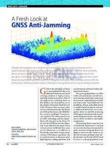
where 𝑟̂𝑖,𝑗 is the estimated range between the i-th and the j-th receivers. Fig. 5 shows an example of hybrid collaborative positioning in indoor propagation conditions, with four users located indoors and one user located outdoors. A single signal snapshot is considered per receiver, and the ranges between receivers are available. The solution obtained when processing independently each of the receivers’ signal snapshot is shown as reference (an open-loop WLS position estimator is used in this case). As can be observed, the collaborative processing allows to mitigate the impact of fading and multipath, substantially reducing the horizontal position errors of the indoor users with respect to the individual solutions (from above hundred meters to tens of meters). The signal model in (1) defines the trivial dependence of the received signal with the state vector of the receiver and the jammer (or spoofer), i.e., 𝑥𝑗 (𝑡𝑗 ) ≜ 𝑥𝑗 (𝚽𝑗 (𝑡𝑗 ), 𝛀(𝑡𝑗 )). Thus, this fact can be exploited to derive not only the location of the receivers, but also the location of the jammer when considering multiple receivers’ signals together, which is a mature topic in the presence of a single jammer, but is still an open problem in the literature for multiple jammers [16]. In particular, the estimation of the jammer’s state vector (including e.g., position and velocity) can be defined as ̂ (𝑡𝑐 ) = arg min ℎ ({𝑥𝑗 (𝚽𝑗 (𝑡𝑗 ), 𝛀(𝑡𝑐 )))}𝑁 ) , 𝛀 𝑗=1 𝛀(𝑡𝑐 )
Date of current version: November 2017
(5)
where the dependence of the received signals with the jammer’s state vector is included, and in this case the estimation approach is defined by the cost function ℎ(𝑥). A possible implementation of (5) can be found in [16], where the eventual presence of multiple jammers is considered. Fig. 6 shows an example of the localization results obtained when considering four RoOs and one or two jammers. As can be observed, horizontal localization errors in the order of few meters can be achieved even in the presence of two jammers located close-by (see [16] for further details). Last, but not least, the positions of all the receivers and jammers/spoofers could be jointly estimated as {𝐩 ̂1 (𝑡1 ) … 𝐩 ̂𝑁 (𝑡𝑁 ), 𝐩 ̂Ω (𝑡𝑐 )} = arg
min
{𝐩1 (𝑡1 )…𝐩𝑁 (𝑡𝑁 ),𝐩𝛀 (𝑡𝑐 ))}
𝑁
𝑝 ({𝑥𝑗 (𝐩𝑗 (𝑡𝑗 ), 𝐩Ω (𝑡𝑐 )))}𝑗=1 )
(6)
in order to further consider the impact of the jammers/spoofers on the position solution of all the receivers (at the cost of a very high computational burden). To the best knowledge of the authors, this approach has so far not been studied. Although the availability of the received signals for each of the RoOs enables the application of advanced signal processing techniques in the Cloud, there are applications in which the availability of the received signals is not strictly necessary. Moreover, some receivers, users and applications might be not interested in transmitting signal snapshots to the Cloud due to e.g., cost, power, latency or privacy reasons (i.e., the full tracking of the GNSS signals is required to be performed on-chip). In these cases, besides the exploitation in the Cloud of the GNSS observables estimated by the receiver, it could be interesting to transmit the complex correlation samples at the output of the receiver’s correlators. This could enable the further exploitation of those correlation samples in the Cloud (since they contain more information than the observables estimated by the receiver based on them), without
conditions (e.g., low-cost platforms, synchronization between devices, etc.) the actual advantages that can offer.
150
100
DISCLAIMER The views presented in the paper represent solely the opinion of the authors and not necessarily the view of ESA.
50
Y [m]
0 Indoor #1 Indoor #2 Indoor #3 Indoor #4 Outdoor Collabor - indoor #1 Collabor - indoor #2 Collabor - indoor #3 Collabor - indoor #4 Thuth positions
-50
-100
-150
-200 -150
-100
-50
0
50
100
REFERENCES [1]
[2]
[3]
150
X [m]
Fig. 5. Example of hybrid collaborative positioning in indoor conditions. In red, individual solutions obtained for each receiver. In blue, collaborative solutions. 100 Monte-Carlo runs considered per estimator.
[4]
[5] [6] [7]
40
[8] 20
Y [m]
[9] 0
Jammer #1
Jammer #2
[10]
-20 Multiple Jammers Localisation Single Jammer Localisation - Jammer #1 Single Jammer Localisation - Jammer #2 True Jammers Position RoOs
-40
[11] [12]
-60 -60
-40
-20
0
20
40
[13]
X [m]
Fig. 6. Example of jammers’ localization in the presence of one or two jammers based on the signal snapshots from four RoOs. 1000 Monte-Carlo runs considered per configuration (see [16] for further details).
[14]
[15]
the need of transmitting the received signal. IV. CONCLUSION Some of the applications and techniques boosted by the Cloud-GNSS framework have been briefly discussed, focusing on the exploitation of distributed receivers of opportunity located in close-by locations. The collaborative processing of distributed RoOs is a promising research area that might play an important role in the near future to solve some of the limitations faced by current GNSS receivers in harsh propagation conditions (e.g., urban and indoor conditions) or in the presence of jamming and spoofing attacks. Nevertheless, the collaborative Cloud-GNSS concept, and the associated signal processing techniques, still need to be studied in detail in order to demonstrate in real operational
Date of current version: November 2017
[16]
[17] [18]
[19]
[20] [21]
A. Botta, W. de Donato, V. Persico, and A. Pescape, “Integration of cloud computing and internet of things: a survey,” Future Generation Computer Systems, vol. 56, pp. 684–700, 2016. S. Babu, A. Lakshmi, and B. Rao, “A study on cloud based internet of things: Cloudiot,” in Global Conference on Communication Technologies (GCCT), Thuckalay, India, 2015. M. Armbrust, A. Fox, R. Griffith, A. D. Joseph, R. Katz, A. Konwinski, G. Lee, D. Patterson, A. Rabkin, I. Stoica et al., “A view of cloud computing,” Communications of the ACM, vol. 53, no. 4, pp. 50–58, 2010. A.R. Biswas, and R. Giaffreda, “IoT and Cloud Convergence: Opportunities and Challenges”, 2014 IEEE World Forum on Internet of Things (WF-IoT). 3GPP Release 15, http://www.3gpp.org/release-15 L. Mossucca, et al., “GNSS based services on cloud environment”, CISIS 2013, Taichung, July 2013. Baseband Technologies Inc., “Snapshot Positioning. Next Generation GNSS Receiver for Low Power Applications”, http://basebandtech.com/wp-content/uploads/Snapshot-Receiver.pdf. Rx Networks Inc., “Ultra-sensitive GNSS receiver”, September 2015, http://rxnetworks.com/wp-content/uploads/2015/09/Product-Brief-UltraSensitive-GNSS-Receiver-v2-Sept-2015.pdf. Inside GNSS, “QinetiQ, Notthingham Scientific Demonstrate CloudBased Galileo PRS Technology”, August 2, 2013, http://www.insidegnss.com/node/3662. V. Lucas-Sabola, G. Seco-Granados, J. A. Lopez-Salcedo, J. A. GarciaMolina, M. Crisci, “Demonstration of Cloud GNSS Signal Processing,” ION GNSS 2016, Sep 2016. F. S. T. Van Diggelen, A-GPS: Assisted GPS, GNSS, and SBAS. Artech House, 2009. P. Mazumdar, V.J. Ribeiro, S. Tewari, “Generating indoor maps by crowdsourcing positioning data from smartphones,” 2014 International Conference on Indoor Positioning and Indoor Navigation, October 2014. D. Dardari, P. Closas, P.M. Djuric, “Indoor Tracking: Theory, Methods, and Technologies,” IEEE Transactions on Vehicular Technology, Vol. 64, No. 4, February 2015. P. Levchev, M.N. Krishnan, C. Yu, J. Menke, A. Zakhor, “Simultaneous Fingerprinting and Mapping for Multimodal and WiFi Indoor Positioning,” 2014 International Conference on Indoor Positioning and Indoor Navigation (IPIN), October 2014. R. Garello, J. Samson, M. Spiritio, H. Wymeersch, “Peer-to-Peer Cooperative Positioning. Part II: Hybrid Devices with GNSS & Terrestrial Ranging Capability,” Inside GNSS, pp. 56-64, July/August 2012. J. A. Garcia-Molina and M. Crisci, “Snapshot Localisation of Multiple Jammers based on Receivers of Opportunity,” NAVITEC 2016, Dec. 2016. GNSS-SDR, http://gnss-sdr.org. C. Mensing, S. Sand, and A. Dammann, “Hybrid data fusion and tracking for positioning with GNSS and 3GPP-LTE,” International Journal of Navigation and Observation, 2010. L. Jie, F. Meng-yin, “Research on route planning and map-matching in vehicle GPS/dead-reckoning/electronic map integrated navigation system”, IEEE Proceedings on Intelligent Transports Systems, Vol. 2, Oct. 2013. P. Groves, “Shadow Matching: A New GNSS Positioning Technique for Urban Canyons,” Journal of Navigation, 64(3):417–430, 2011. M. Bartolucci, J.A. del Peral-Rosado, R. Estatuet-Castillo, J. A. GarciaMolina, M. Crisci, and G. E. Corazza, “Synchronisation of Low-Cost Open Source SDRs for Navigation Applications,” NAVITEC 2016, Dec. 2016.