USING THE DLR EXPERIMENTAL BI-SPECTRAL. INFRARED DETECTION (BIRD) SMALL SATELLITE. Anke Tetzlaff a,b. , Andreas Hirner a. , Boris Zhukov a*.
COAL FIRE QUANTIFICATION AND DETECTION USING THE DLR EXPERIMENTAL BI-SPECTRAL INFRARED DETECTION (BIRD) SMALL SATELLITE Anke Tetzlaff a,b, Andreas Hirner a, Boris Zhukov a*, Claudia Kuenzer a and Stefan Voigt a a) German Aerospace Centre (DLR), Oberpfaffenhofen and Berlin (*), Germany b) Current affiliation: Swedish Meteorological and Hydrological Institute (SMHI), Norrköping, Sweden ABSTRACT Coal fires cause severe environmental and economic problems worldwide. In the current paper we analyse the potential of the experimental bi-spectral infrared detection (BIRD) small satellite to register coal fire related spectral radiances and we present BIRD data acquired over two coal fire areas in Northern China. Based on field observations of coal fires in the investigated areas, we visually outline potential coal fire areas on BIRD data and apply the Bi-spectral technique [1] to estimate potential coal fire temperatures, sizes and radiative energy releases. We compare the BIRD derived quantitative coal fire parameters to field measurements from two field campaigns carried out in September 2003 and September 2003 in China. This study demonstrates that in particular BIRD night-time data have a high potential to register coal fires. The majority of the coal fire areas in the investigated coalfields can be clearly outlined on BIRD night-time data. In addition, BIRD derived coal fire temperatures correlate well with field observations indicating the high potential of the BIRD technology to derive physical meaningful coal seam fire parameters. The comparison of ETM and BIRD data reveals that the BIRD MIR spectral band is radiometrically more sensitive to coal fires than the ETM TIR spectral channel. However, the factor six higher spatial resolution of the ETM allows it to perform better than BIRD at night-time. 1
INTRODUCTION
Coal fires occur worldwide in surface and underground coal seams. They result in a reduction of the coal reserve, attribute to atmospheric pollution through the emission of greenhouse related gases, cause land subsidence and negatively impact human health in nearby areas. China, as the worlds’ largest coal producer, faces the world’s biggest coal fire problem [2]. Within the framework of a Sino-German geo-scientific Coal Fire Research Initiative the German Aerospace Centre (DLR) has investigated the potential of the experimental BIRD small satellite to detect and quantify coal fires in Northern China. Recent field investigations [3, 4] have demonstrated that coal fire related surface anomalies are very subtle, small in area and are, with average surface temperatures ranging between 350 K and 550 K, significantly colder than forest or grassland fires. A satellite
data based coal fire quantification thus poses a challenge to the sensor technology. The BIRD satellite is a technology demonstrator mission of new infrared pushbroom channels, specifically designed to support the detection and quantification of hot spots on the earth’s surface. The satellite carries the Hot Spot Recognition System (HSRS), which includes two well-separated thermal channels with a spatial resolution of 370 m: a mid infrared band centred at 3.8 µm (MIR channel) and a thermal infrared band centred at 8.9 µm (TIR channel). The high radiometric resolution, combined with the fact that the HSRS does not have an upper saturation limit, is compared to recent operational satellite sensors a major advantage for fire quantification studies [5]. In this study we theoretically analyse the potential of the BIRD HSRS sensor to register spectral coal fire radiances. We compare BIRD derived coal fire surface temperature estimates with field observations and we present a detailed comparison between estimates of coal fire radiative energy releases (CFRE) calculated from BIRD HSRS and operational Enhanced Thematic Mapper (ETM) sensor data. The presented analysis outlines both the possibilities and limitations of the BIRD HSRS technology for coal fire quantification studies. 2
METHODS
In order to provide ground truth data for the BIRD HSRS data based coal fire analysis, two coalfields in Northern China were investigated during two field campaigns in September 2002 and 2003. The field investigations included a detailed mapping of coal fire related surface anomaly zones as well as coal fire surface temperature measurements. Based on the field measurements BIRD HSRS MIR and TIR spectral radiances of coal fire scenarios were simulated. The simulations were conducted for different background conditions including night-time as well as daytime simulations. BIRD HSRS day- and night-time imaging of the two study coalfields was performed with a maximum half year temporal offset to the field observations. The satellite data were atmospherically and geometrically corrected using MODTRAN code [6] derived lookup tables and ground control points taken with a GPS device during the field campaigns. The pre-processed BIRD MIR data was used to visually outline potential coal fire pixels. In order to distinguish coal fire related anomaly pixels from background pixels, an adaptive threshold was set within a visually defined window around each corresponding coal fire area, mapped during the field campaign in September 2002. The equivalent coal fire temperature and sizes of BIRD HSRS detected coal fire anomaly zones were calculated using the commonly used Bi-spectral technique [1] using both MIR and TIR data. In order to check the stability of the bi-spectral retrievals to variations of the TIR background signal, the calculations were performed for the mean value of the TIR background radiance as well as the mean value minus/plus one standard derivation of the TIR background radiance. The radiative energy release of the investigated coal fire zones was estimated similar to the approach of Wooster et. al. [7] using the StefanBoltzmann law and the BIRD HSRS derived Bi-spectral temperature and size estimates. In addition to the BIRD HSRS data ETM daytime and night-time data acquired within a similar time window as the BIRD data were analysed. The pre-processing and the coal fire
detection was performed similar to the BIRD data analysis, however, due to the fact that the ETM sensor has not a mid-infrared channel, only TIR band data were investigated. Coal fire radiative energy releases were computed via ETM TIR data using the recently presented so-called TIR method [4] and the computed values were directly compared to BIRD CFRE estimates. The TIR band method is based on a semi-empirical relationship between the coal fire spectral radiances measured in the TIR channel of the ETM instrument and the total CFRE emitted over all wavelengths. 3
RESULTS
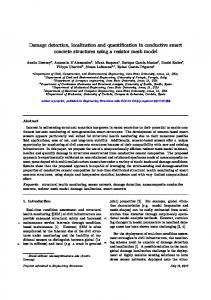
The theoretical simulations demonstrate that only relatively large and/or hot coal fire related surface anomaly zones can be registered by the BIRD HSRS sensor. Against an absolute homogeneous night-time winter background, 500 K to 600 K coal fire surface anomalies can be registered from a size of approximately 15 m² onward in the BIRD MIR channel, while 400 K surface anomalies need to exceed 400 m². In general, the BIRD MIR spectral range is found to be significantly more sensitive to coal fire radiances than the BIRD TIR spectral range. Figure 1 illustrates BIRD and ETM thermal night-time data and corresponding energy images of the Ruqigou and Gulaben study coalfield in Northern China. 14 out of 18 coal fire zones can be clearly outlined on BIRD night-time data. Due to the higher spatial resolution of the ETM TIR data, more coal fire zones can be highlighted on ETM TIR data. However, the compared to the BIRD MIR channel higher background temperature variations of the ETM TIR band data, make a visual coal fire inspection of the ETM data significantly more difficult. Similar results were found for the second study area. The BIRD bi-spectral coal fire temperature retrievals range between 331 K and 600 K and appear to be in very good correlation with the observed coal fire surface temperatures. CFRE estimates derived from BIRD night-time data vary with respect to TIR background temperature variations approximately +/- 40 % and can thus be considered to be relatively stable. BIRD derived CFRE values are for large coal fire clusters in good correlation with ETM derived CFRE values. However, the total energy release derived from BIRD HSRS night-time data for the investigated coalfields is about a factor three smaller than the total energy release computed from ETM night-time data reflecting the coarse spatial resolution of the BIRD data. 4
CONCLUSIONS
This study has demonstrated that despite the relatively coarse spatial resolution of the BIRD HSRC sensor, coal fires can be successfully detected. However, the low spatial resolution of the BIRD data prevents some of the low radiative coal fire components from being detected and therefore total computed CFRE energy releases are significantly lower than CFRE estimates based on ETM data. Both the theoretical evaluations as well as the case study demonstrate that the MIR spectral range is more radiometrically sensitive to coal fires than the TIR range. It is thus recommended that future satellite sensors, dedicated to the problem of coal seam fire
detection and analysis under both in daytime and night-time conditions, have a nonsaturating MIR and a TIR channel with a spatial resolution of at least 100 m or better. The good agreement reported for BIRD derived coal fire temperatures and field observations indicates that physically meaningful coal fire parameters can be derived via the investigated small satellite instrument.
3
Figure 1: BIRD TIR and ETM MIR band with superimposed coal fire surface anomalies (red outlines) of the Ruqigou and Gulaben coalfield in Northern China (left) and corresponding radiative energy release images of detected coal fire clusters (right). Upper left) BIRD MIR band, 16.01.03 night-time; upper right) corresponding radiative energy releases. Lower left) ETM TIR Band, 28.09.02 night-time; lower right) corresponding radiative energy releases.
5
REFERENCES
[1] DOZIER, J., 1981, A method of satellite identification of surface temperature fields of sub-pixel resolution. Remote Sensing of Environment, 11, 221-229. [2] VOIGT, S., TETZLAFF, A., ZHANG, J., KUENZER, C., ZHUKOV, B., STRUNZ, G., OERTEL, D., ROTH, A., VAN DIJK, P. and MEHL, H., 2004, Integrating Satellite Remote Sensing Techniques for
Detection and Analysis of Uncontrolled Coal Seam Fires in North China. International Journal of Coal Geology, 59, 121-136. [3] ZHANG, J., 2004, Spatial and Statistical Analysis of Thermal Satellite Imagery for Extraction of Coal Fire Related Anomalies. PhD thesis at the University of Vienna, Austria. [4] TETZLAFF, A., ZHUKOV, B., ALTERMANN, W., HECKER, C., ZHANG, J., KÜNZER, C., HIRNER, A., and VOIGT, S., submitted, Estimation of coal fire related surface energy releases using ETM and BIRD experimental satellite sensor data: A satellite image based approach to quantify coal fires on a regional scale. International Journal of Remote Sensing. [5] SKRBEK, W., and LORENZ, E., 1998, HSRC-an infrared sensor for hot spot detection. Infrared Spaceborne Remote Sensing IV (Denver, US), pp.167-176. [6] BERK, A., BERNSTEIN, L. S., and REBERTSON, D. C., 1998, MODTRAN: a moderate resolution model for LOWTRAN 7. Final Report GL-TR-89-0122, U.S. Air Force Systems Command, USA. [7] WOOSTER, M. J., ZHUKOV, B., and OERTEL, D., 2003, Fire radiative energy for quantitative study of biomass burning: derivation from the BIRD experimental satellite and comparison to MODIS fire products. Remote Sensing of Environment, 86, 83-107.
>
>