Remote Sens. 2011, 3, 1743-1776; doi:10.3390/rs3081743 OPEN ACCESS
Remote Sensing ISSN 2072-4292 www.mdpi.com/journal/remotesensing Review
Collective Sensing: Integrating Geospatial Technologies to Understand Urban Systems—An Overview Thomas Blaschke 1,2,*, Geoffrey J. Hay 3, Qihao Weng 4 and Bernd Resch 2 1 2
3
4
Centre for Geoinformatics, University of Salzburg, Hellbrunner Str. 34, A-5020 Salzburg, Austria Research Studio iSPACE, Research Studios Austria, Schillerstr. 25, A-5020 Salzburg, Austria; E-Mail:
[email protected] Department of Geography, University of Calgary, 2500 University Dr. N.W., Calgary, AB T2N 1N4, Canada; E-Mail:
[email protected] Center for Urban and Environmental Change, Department of Earth and Environmental Systems, Indiana State University, Terre Haute, IN 47809, USA; E-Mail:
[email protected]
* Author to whom correspondence should be addressed; E-Mail:
[email protected]; Tel.: +43-664-8044-5222; Fax: +43-664-8044-5222. Received: 24 June 2011; in revised form: 5 August 2011 / Accepted: 10 August 2011 / Published: 19 August 2011
Abstract: Cities are complex systems composed of numerous interacting components that evolve over multiple spatio-temporal scales. Consequently, no single data source is sufficient to satisfy the information needs required to map, monitor, model, and ultimately understand and manage our interaction within such urban systems. Remote sensing technology provides a key data source for mapping such environments, but is not sufficient for fully understanding them. In this article we provide a condensed urban perspective of critical geospatial technologies and techniques: (i) Remote Sensing; (ii) Geographic Information Systems; (iii) object-based image analysis; and (iv) sensor webs, and recommend a holistic integration of these technologies within the language of open geospatial consortium (OGC) standards in-order to more fully understand urban systems. We then discuss the potential of this integration and conclude that this extends the monitoring and mapping options beyond “hard infrastructure” by addressing “humans as sensors”, mobility and human-environment interactions, and future improvements to quality of life and of social infrastructures.
Remote Sens. 2011, 3
1744
Keywords: urban remote sensing; collective sensing; in situ sensing; sensor web; human-environment interactions; future trends; smart city
1. Introduction Cities are complex systems, composed of myriad biological and non-biological components that function and interact within multiple coincident spatio-temporal scales: from the split-second delay of a changing traffic light, to the diurnal pulse of city night-life, to the seasonal hum of power stations meeting increased energy demands. Cities are alive. They breathe, they evolve and within this new geological epoch—the Anthropocene or “The Age of Man” [1], we are changing the face of our planet in order to meet their increasing appetites. In the 1800s, the urban fraction of the global population was 3%. Today it is estimated that 50.6% of the world’s population currently live in urban areas that occupy only ≈1% of the planets total land area [2]. Additionally, annual urban growth rates continue to increase at a more rapid pace (1.91%), than rural populations (0.22%) [3] leading to a host of urban challenges from affordable housing, increased urban unemployment and traffic congestion, to rising energy demands, urban heat island effects and increased air and noise pollution to name just a few [4,5]. Understanding how these urban systems evolve (their past, present and future) is paramount to maximizing our human living experience within their changing boundaries; yet no single perspective is sufficient to achieve this task. In this article we provide a condensed perspective of critical geospatial technologies necessary to understand, model and monitor cities from above, below, within and from a distance-over multiple collection scales; with an emphasis on the importance of implementing open geospatial consortium (OGC) sensor standards (see Section 3.2). The term “city” comprises not only a geographical area characterized by a dense accumulation of people or buildings, but implicitly includes a multi-layered construct containing multiple dimensions of social, technological and physical interconnections and services. A variety of terms have emerged to describe this evolving urban environment, including virtual city, city of bits, event city, cyber city, global city, network city, and renewable city [6]. Naturally, these terms depend on the specific viewpoint(s) representing the complexity of the phenomena being observed and analyzed. Hall [7] characterized this multi-dimensional complexity covering culture, politics, trade, communications infrastructure, finance, technology and universities. Hall and Pfeiffer [8] further state that a liveable city has many facets, which revolve around quality of life functions such as living space, elementary infrastructure, traffic and land utilization. Castells [9] pursues another approach describing a city as “not a place, but a process”. In this context, processes are considered the connections between centers in a global network. Castells further imagines the city as a spatial system of advanced service activities, and claims that information and communication networks constitute the modern social morphology of our societies in the informational age—as opposed to the industrial age. A more economy-driven view is presented by Friedmann [10], who states that cities are the basing points of capital, and the resulting linkages create a complex spatial hierarchy. In his interpretation, this hierarchy is formed by taking a number of city characteristics into account: the importance of the city as a finance centre, corporate headquarters,
R Remote Senss. 2011, 3
17445
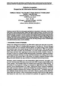
ulation size. innternationall institutionns, businesss servicess, manufactturing, trannsportation,, and popu S Similarly, a very energyy-centered description of urban en nvironments is presentted by Droeege [11], whho s sees the com mmon aspecct of cities in i their founndation as “creatures “ o their enerrgy regimess”. He asserrts of thhat a large part of globbal financiaal transactioons, trade, command c annd control, and culturaal productioon o occur in andd among citties. Mitcheell [12] alsoo lays out a multi-dimeensional deffinition of the t term cityy, w which is strrongly motivated by teechnology. He H states th hat the futuure city willl be (i) unrrooted to anny d definite geoographic plaace on the surface s of the t earth; (iii) constrainned by connnectivity an nd bandwidtth isssues ratheer than by physical acccessibility and land values; andd (iii) wideely asynchrronous in its o operation. T inhabitaants are noot humans, but agents,, which Miitchell describes as “ccollections of The o a aliases and agents”. a Moore recentlyy, several off these ideass have been realized wiithin a grow wing researcch d domain on cellular c autoomata and agent-based a models [13 3]. Despite thheir diversiity of approaches, almoost all studiees reveal hoow the citiess in which we w live, havve c changed. Thhere is no siingle univerrsal way of describing cities and urbanity, u butt rather, num merous wayys o exploringg the city together of t wiith their inhhabitants. Figure F 1 deepicts somee of these methods. m A As illlustrated, one o commonnly used meethod is to produce p a map. m Figuree 1. Inform mal settlem ments in Foortaleza, Brrazil: (a) prrivately floown aerial photos (2005)); (b) a diggital classiffication of settlement s structures, settlement in red (Blaaschke, unpubblished); (c) a ground inspection i r reveals various structurral and sociial changess which are not depicted inn the nadir optical imaages (photo: Blaschke, 2006). 2
(a)
(b b)
(c)
R Remote Senss. 2011, 3
17446
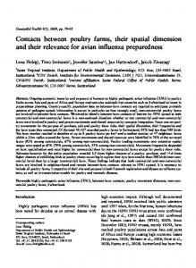
Remote sensing s imaagery (i.e., from satelllite and or airborne seensors) ofteen provides the primarry d source to achieve a birds-eye,, or plan-vieew of an urrban setting. However, such traditionally statiic data m maps are inncreasingly inefficient for represeenting dynam mic urban environmennts. Instead, we suggeest thhat what is needed is a seamless integration i o multiscalle geospatiaal technologgies, where real-time of r annd n near-real-tim me digital maps m act as a geospatiial strange--attractors that t dynam mically harb bor spatiallly r referenced informationn and assoociated mettadata. Ourr hypothesis is that rremote sensing is weell a advanced inn terms of teechnologies and methodds including g multi-sensor, multi-sscale and mu ulti-temporal a analyses butt that it is primarily limited l to a “roof-top//treetop” viiew-althouggh SAR plaatforms ofteen p provide obliique data-whhich represeents an incoomplete perspective forr understandding urban systems. s Figure 2 illustrates this t hypothhesis and the different perspectivees derived ffrom both “remote” “ annd “ situ” sennsing. For simplicity we “in w employ a “wall to o wall” mapp metaphor for the rem mote sensinng The in situ sensing e example, w which shoulld include feature exxtraction approaches. a g process is c characterize d with the processing chain sincee most indiividual systtems are noot developed d to derive a “ “complete” p picture of thhe environm ment. Our objective o is to t contributte to a betterr understanding of thesse iddeas, and too provide solutions. s Inn the proceeeding sectio ons we willl explore thhese ideas by b describinng k componnents of (i) Remote key R Sennsing; (ii) Geographic G Informationn Systems; (iii) object--based imagge a analysis tecchnologies; and (iv) thhe sensor web, w and we w will disccuss opporttunities to exploit eacch teechnology’s strengths to create an a integrateed understan nding of dyynamic urbaan systems.. Finally, we w w discuss multi-sourcce sensing, “collective sensing” an will nd germane terms usedd in Computter Science. Figuree 2. The “pplan-view” concepts off remote sen nsing (1) annd “personaal” in situ sensing s (2) aree juxtaposedd in terms of o their resullts.
Remote Sens. 2011, 3
1747
2 Remote Sensing and the Urban Environment 2.1. Progress in Technology Current airborne and satellite remote sensing sensors have significantly advanced, since the first recorded nadir air photograph was acquired from a hot air balloon over the city of Paris in 1858 ([14], p. 67). For example, airborne hyperspectral sensors such as the CASI 1500 [15] provide a 650 nm spectral range between 365 and 1,050 nm, 288 programmable spectral samples (