ICES CM 2003/P:33 Combining Eulerian and Lagrangian numerical approaches to investigate the influence of hydrodynamic variability on the transport of sediment and fish eggs E. W. North, R. R. Hood, S.-Y. Chao, L. P. Sanford University of Maryland Center for Environmental Science, Horn Point Laboratory P. O. Box 775, Cambridge, MD, 21613, USA [tel: +1 410 228 8200, fax +1 410 221 8490, e-mail:
[email protected],
[email protected],
[email protected],
[email protected]] ABSTRACT Numerical approaches were developed for the purpose of investigating the influence of hydrodynamic variability on the transport of fish eggs and sediment near a frontal zone. The Princeton Ocean Model (POM) was adapted to a straight-channel estuary and enhanced with sediment settling, erosion, deposition and burial components. In addition to Eulerian sediment modeling, a Lagrangian particle tracking model was constructed within the numerical circulation model to simulate the transport of individual sediment particles and fish eggs in the flow field. A random displacement model (RDM) was implemented within the particle tracking model to parameterize sub-grid scale turbulence. Tests of the Well Mixed Condition suggest that the RDM significantly reduced numerical artifacts that can occur when simulating particle motion in regions with high gradients in turbulence. In addition, comparison between Lagrangian particle distributions and Eulerian tracer concentrations suggest that Lagrangian particle motion reasonably approximated tracer dispersal, especially in the vertical direction. The coupled Eulerian-Lagrangian model has the potential to be a powerful tool for investigating the influence of hydrodynamic variability on the transport and potential survival of fish early-life stages in frontal zones. INTRODUCTION Advancing understanding of biological-physical interactions in frontal zones is an important avenue of research. Frontal regions are ubiquitous throughout the world’s estuaries and coastal oceans where important recreational and commercial fisheries occur. Fronts structure physical conditions such as temperature, salinity, and nutrient concentrations (Largier 1993) as well as the distribution of planktonic organisms including phytoplankton (Hood et al. 1991, Uye et al. 1992, Franks and Walstad 1997), crustacean zooplankton (Jillett and Zeldis 1985, Epifanio 1987, Mackas and Louttit 1988, Okazaki et al. 1998, Shanks et al. 2000, Epstein and Beardsley 2001), and fish larvae (Govoni et al. 1989, Govoni and Grimes 1992, Govoni 1993, 1997, Kingsford and Suthers 1996, Munk et al. 1999, Nakata et al. 2000, Lough and Manning 2001, Bjorkstedt at al 2002, Munk et al. 2002, North and Houde in press). The physical and biological characteristics of frontal regions are hypothesized to be important areas for growth of plankton due to enhanced nutrient concentrations and convergent circulation that can promote production, increase aggregation of organisms, and intensify trophic interactions (Wolanski and Hamner 1988, Boynton et al. 1997, Winkler et al. 2003). Lagrangian particle tracking models coupled with hydrodynamic models have been used to gain new insight on how planktonic dispersal and growth are mediated by physical conditions (Werner et al. 1996, Hannah et al. 1998, Heath and Gallego 1998, Hare et al. 1999, Bartsch and Coombs 2001, Hinckley et al. 2001, Werner et al. 2001). These models move individual particles through time and space using current velocities output from the hydrodynamic model. To accurately portray particle motion, Lagrangian particle tracking models include a sub-grid scale turbulence model to simulate turbulent motion at scales smaller than those resolved by the hydrodynamic model. Correct parameterization of sub-grid scale turbulence in Lagrangian particle tracking models presents challenges in frontal regions due to numerical artifacts. When implemented in hydrodynamic models that contain sharp gradients in turbulence (e.g., fronts), sub-grid scale turbulence models that employ a
1
ICES CM 2003/P:33
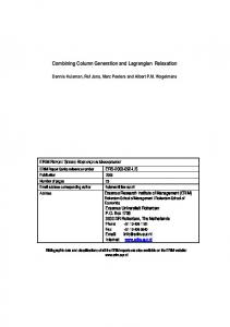
Figure 1. ETM hydrodynamic model output and particle distributions. a) Hydrodynamic model output at day 350. Line contours are salinity, arrows are vectors, and shaded contours are suspended sediment concentrations (kg m-3) with color scale on right. b) Initial random distribution of 50,000 particles in the particle tracking model domain. c) Particle distribution after 6 hr when a random walk model was used to simulate sub-grid scale turbulence in the vertical direction. d) Particle distribution after 6 hr when a random displacement model (Visser 1997) was used to simulate sub-grid scale turbulence in the vertical direction. Particle colors correspond to depth of initial release.
2
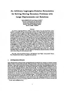
ICES CM 2003/P:33 random walk model result in artificial aggregation of neutrally buoyant particles in areas of low diffusivity, violating the Well Mixed Condition (Visser 1997, Brickman and Smith 2001). Particle tracking models that adhere to the Well Mixed Condition maintain “an initially uniform concentration of [neutrally buoyant] particles uniform for all time” (Brickman and Smith 2002). Failure of the random walk model to meet the Well Mixed Condition is clearly evident in a model of the salt front (landward margin of salinity intrusion) at the head of many coastal plain estuaries (Fig. 1c). In contrast, a random displacement model (RDM) used to simulate sub-grid scale turbulence (Visser 1997) is much more successful (Figure 1d). The salt front at the head of estuaries is an ideal test case to advance numerical approaches and enhance our understanding of biological-physical interactions in frontal regions. Strong gradients in vertical diffusivity (turbulence) in this region present a numerical challenge for particle tracking models. But, improved modeling in this region likely will advance our understanding of fisheries recruitment. This region is an important anadromous fish nursery area, and field evidence suggests that physical conditions may have a strong influence on larval fish survival and juvenile recruitment (North and Houde 2001, in press). Circulation patterns near the salt front can create an estuarine turbidity maximum (ETM). ETMs, characterized by elevated turbidity and suspended sediment concentrations compared to those upand down-estuary, are found in coastal plain estuaries throughout the world (Schubel 1968), including estuaries in Canada, France, Germany, UK, and USA (Schubel 1968, Allen et al. 1980, D’Anglejan 1981, Uncles and Stephens 1993, Jay and Musiak 1994, Burau et al. 1998, Geyer et al. 2001, Kappenberg and Grabemann 2001, Lin and Kuo 2001, Sanford et al. 2001, Kostaschuk 2002). The ETM region is an important nursery area for larval fish in the St. Lawrence River estuary (Dodson et al. 1989, Dauvin and Dodson 1990, Sirois and Dodson 2000), the San Francisco Bay/Delta (Jassby et al. 1995, Bennett et al. 2002), and upper Chesapeake Bay (Boynton et al. 1997; North and Houde 2001, in press). The numerical hydrodynamic model employed in this research reproduces an ETM (Fig. 1a), and the Lagrangian particle tracking model simulates the movement of fish eggs in this region. This paper describes a method for implementing a random displacement model in a Lagrangian particle tracking model, summarizes tests of the Well Mixed Condition (WMC), and presents results of comparisons between Eulerian tracer and Lagrangian particle distributions. Examples of how the coupled Eulerian-Lagrangian particle tracking models can be used to better understand the influence of hydrodynamic variability on the transport of fish eggs in a frontal zone will be presented at the 2003 ICES Annual Science Conference. METHODS Hydrodynamic and sediment transport model. The three-dimensional hydrodynamic ETM model is based on the code of the Princeton Ocean Model (POM) (Blumberg and Mellor 1987, Mellor 1998) under hydrostatic and Boussinesq approximations. Eddy viscosity and diffusivity is determined by the level-2.5 turbulent closure scheme of Mellor and Yamada (1974). Our enhancements to POM include building suspended sediment and sediment 98 km ∆x = 1.0 km transport components that track bottom sediment concentrations, adding constant loading of suspended sediment at the up-stream boundary, parameterizing bottom sediment burial with a 4.8 km Newtonian dampening term, and constructing a ∆y = 0.8 km Seaward more reasonable formulation for background Reservoir: diffusivity. 2,237 km 2141 km long 62.7 kmlong wide
The ETM model domain (Figure 3) contains a 98-km long and 4.8-km wide channel with a
Fig. 3. Schematic of hydrodynamic model 3
ICES CM 2003/P:33 gradually widening seaward reservoir that is 2,237 km long and has a maximum width of 66 km. The entire basin is 12 m deep and contains 145 grid spacings in the x-direction (seaward) and 6 in the ydirection (across channel). Vertical resolution is provided by 12 sigma-coordinate layers. In the first 98 km of the channel, the longitudinal resolution (∆x) is 1 km and the lateral resolution (∆y) is 0.8 km. In the seaward reservoir, ∆x and ∆y gradually increase at a rate of 12 and 5.5 percent per grid, respectively. The seaward reservoir, although of minor importance to the circulation and sediment transport within the channel, serves as a buffer zone to enhance the long-term computational stability of the model. The temporal resolution of the model is split. Vertically averaged currents and sea level are resolved with a time step of 5 s, and salinity, sediment concentration, and vertically explicit current velocities are resolved with a time step of 40 s. A barotropic tidal generation force is included in the longitudinal momentum equation to produce semidiurnal tidal currents in the channel. Tidal current speed and upstream dissipation are parameterized so that sea level height and tidal current velocities in the model are similar to those of predicted tides in upper Chesapeake Bay. Lateral walls bounding the channel are impenetrable, impermeable and free-slip. Further information regarding model parameterization and boundary condition is forthcoming (North et al. in press) and can be obtained by contacting the authors. Initially, the model channel was filled with motionless clear water of 12 practical salinity units (psu). The model was run with river inflow = 0.07 m s-1 and constant sediment loading until the model reached a quasi steady-state at day 350. In this quasi steady-state, sediment input equaled sediment burial and the location of the salt front was stable: it oscillated with the tidal current in a repetitive cycle but did not progress up or down estuary. All model scenarios use the quasi steady-state solution at day 350 as the initial condition. Particle tracking model formulation. The Lagrangian particle tracking model is a subroutine of the hydrodynamic model that is called every internal time step (40 s). Current velocity, sea surface height, horizontal and vertical diffusivity, kinematic viscosity and water density derived in the hydrodynamic model are passed to the particle tracking model. Changes in particle locations due to advection are calculated every 10 s using an 8-point interpolation of U, V, and W velocities at the particle location. Near the bottom, the law-of-the-wall is applied so that u-, v-, and w-velocities decrease logarithmically to the depth of the roughness height (0.001 m). The hydrodynamic model is tuned to examine along-channel processes. Because cross-channel displacement of particles is < 38 m in 10 days, sub-grid scale turbulence in the Lagrangian model is parameterized in the vertical (z) and along-channel (x) directions, not in the cross-channel direction (y). Turbulence in the along-channel direction. A random walk model (RWM) (Visser 1997) was implemented within the particle tracking model to simulate sub-grid scale turbulence in the horizontal direction (x): xn+1= xn + c R{ 2r-1 Kh ∂t }1/2 where z = particle position at horizontal location n, Kh = horizontal diffusivity at the particle location, ∂t = time step of RWM (∂t = 1 sec), c = scaling coefficient (c = 0.2), and R is a random process with mean = 0 and standard deviation r = 1. The scaling coefficient of c = 0.2 results in greater horizontal spreading of particles than in model runs without horizontal sub-grid scale turbulence. For example, when particles were release throughout the water column at river kilometer 16, the maximum distance between particles after 1 hr was 0.71 km when horizontal turbulence was included in the model as opposed to a maximum distance of 0.46 km due to advection alone. A random walk model was used to represent sub-grid scale turbulence in the horizontal direction because we used constant horizontal diffusivity in the ETM model. In situations with constant diffusivity, random walk and random displacement models are equivalent (Visser 1997).
4
ICES CM 2003/P:33 Turbulence in the vertical direction. A random displacement model (Visser 1997) was implemented within the particle tracking model to simulate sub-grid scale turbulence in the vertical (z) direction: zn+1= zn + Kv'(zn) ∂t + R{ 2r-1 Kv[ zn + 0.5 Kv'(zn) ∂t ] ∂t }1/2 where z = particle depth at vertical location n, Kv = vertical diffusivity, ∂t = time step of the RDM, Kv’ = ∂K/ ∂z, and R is a random process with mean = 0 and standard deviation r = 1. To satisfy the RDM criterion ∂t