Economy Informatics, 1-4/2008
68
Conceptual Solution for Mobile Applications Using Virtual Globe Software Lucia RUSU, Sergiu JECAN Babeş-Bolyai University, C luj-Napoca, România Marius SÂRBU Wscomm {lucia.r usu, sergiu.jecan}@econ.ubbcluj.ro,
[email protected] Geospatial software and applications has a huge potential applicability in the fields of agriculture science, natural resource management and spatial planning. Main features of geospatial software and applications are based on several concepts as: coordinate systems, map projection, data types and geodatabases. We analyze software criteria for digital globe selection, based on six categories, with adequate detailed criteria, and we choose several solutions for virtual globe products, in order to select proper software for mobile application. In the present paper the authors propose a conceptual solution for integrate MultiMap UK Microsoft in a mobile application, based on Caramba solution adapted to the objective of MC Locator. This solution was implemented in MC Locator mobile application, which aim is monitoring and management of the auto fleet activities through the use of location and communication equipment based on GPS and GPRS. Keywords: virtual globe products, geospatial concepts, mobile application space, multilayer application.
1
Introduction According to Riedl (2007) virtual hyperglobes or virtual globes, or digital globes, and earth browsers are scale-bound structured models of planets from virtual space in their undistorted three-dimensional wholeness. Virtual globes incorporate features and functionality that provide significant advantage over traditional spatial data mapping interfaces, by allowing the visualisation of digital images on a three dimensional virtual globe structure. These advantage can be bound in three major features: the earth imagery displayed on a globe structure is free of distortion, data displayed in virtual globes can be viewed at any scale and from any angle, a large degree of interactivity, allowing the user to move to different locations and visualise different type of spatial data (Riedl 2007). Former US Vice President Gore’s concept of a Digital Earth is: ‘a multiresolution, three-dimensional representation of the planet, into which we can embed vast quantities of geo-referenced data’ (Gore 1998). After software companies decided to offer
freely downloadable virtual globes, which providing access to online imagery repositories, public interest was increased and all the people understand the role and huge importance of geographical information sciences. In Buttler opinion the ease of use of virtual globes and their capacity to display spatial information offers a strong potential to communicate spatial data and it is believed that virtual globes could lead to a democratisation of GIS technology (Butler 2006). Virtual globes offer an proper too l for publishing spatial information, by underlying high quality satellite and aerial imagery, aiding the teaching of earth sciences and communications, offer a huge accessibility to decision makers based on virtual data and landscape mod els, increase the opportunities for research community and the public (Lisle 2006). In a simple approach geographic information system (GIS) is computer-based data storage and analysis tool that combines previously unrelated information into a comprehensive picture (Rapport, 1999). “Location intelligence uses geographic infor mation system
Economy Informatics, 1-4/2008
(GIS) tools and techniques to transform and analyze data that becomes valuable information to make more informed and rational business decisions. Thus, location intelligence is neither simply an analytic technique nor business process; but a discipline that encompasses both.” (Steiner, 2008). GIS can be applied to: crime reduction, public safety enhancement, sitting new schoo ls, redistricting, floodplain mapping, growth management, disaster recovery, tax mapp ing, economic development, school bus routing, fire station location, land conservation, environmental impact studies, water & sewer expansion, superfund cleanup (Wiki). Graphic presentations and direct access of some types of GIS offers opportunity and power to understand complex relationships, to plan for the future or tomorrow, based on an accurate picture of today, to present data in a clear, compelling way, to make informed decisions and to save time, mone y and even lives (Encyclopedia of GIS). A several data accessibility solutions that can be implemented for many types of GIS data, which require that the data is presented in an alternative, text-based format as well as graphically for accessing and displaying the information depending on the nature of the information being offered (Dimitriu, 2005). Simple data might be presented as a table or series of tables in addition to the map presentation but complex data might have to be sumarised, and key elements of the data presented in tabular form (Shankland, 2008). Now day a huge application offers powerful interactive mapping while hiding the complexity of spatial data queries and the cartographic rendering process from application developers (Butler, 2006). Users and de velopers can customize the appearance and behavior of the map; they can control visua l map characteristics – such as the background color, the title, the symbiology used to portray features such as roads, store locations and property boundaries, and so on using extensible metadata stored in database tables, incorporate dynamically obtained geospatial data, customer locations, and plot these on top of a base map (Steiner, 2008).
69
Our paper focused on digital globe technologies and these features and facilities for mobile applications. After an introduction in virtual hyperglobes and geographic information system (GIS) tools, we focused on features of geospatioal software. In next section we will present software criteria for digital globe selection, based on six categories, with adequate detailed criteria, focused on hardware requirements, type and quality of data provided, capacity to import and data manipulation, sharing grade of data, degree of openness and customization potential, overall performance and stability. In next section we use SWAP analyze for a case study approach of six major digital globes: Google Earth, NASA World Wind, ESRI ArcGIS Explorer, Skyline Globe and Dapple Earth Explorer and MultiMap UK. We show the strength and weaknesses of them and evaluate their potential applicability in the fields of mobile app lication in monitoring and management application of the auto fleet activities. In next section we develop a functional model using MultiMap UK as a digital globe, embedded in distributed application. This model is focused on middleware layers and remote communication 2. Features of geospatial software Main features of geospatial software and applications are based on several concepts as: coordinate systems, map projection, data types and geodatabases. Coordinate systems is a fixed reference framework superimposed onto the surface of an area to designate the pos ition of a point within it. Common coo rdinate systems are geographic (threedimensional), in which locations are measured in degrees of latitude and longitude, and planar (or Cartesian), in which the earth’s surface is projected onto a two-dimensional plane and locations are measured in meters or feet. For representing and access data we need projections - a method of representing the earth's three-dimensional surface as a flat two-dimens ional surface. There are many different map projections, all of them distort shape, area, distance or direction (ESRI, 2003). For instance the Mercator projection
Economy Informatics, 1-4/2008
70
maintains shape and direction, the Sinusoidal and Peters projections both maintain area, but look quite different from each other and the Robinson projection does not enforce any specific properties but is widely used because it makes the earth’s surface and its features "look right." Data management uses different data types: tabular databases, join with vector file by common attribute, mapped as points using coor dinate po ints such as latitude and longitude gathered from a GPS Geocode for associate address field with street file, vector (points, lines, polygons), raster - a mode l of the world as a surface that is divided into a regular grid of cells, arranged into rows and columns, in which all cells must be the same size, images (aerial photographs), grids (derived data representing continuous values such as an elevation surface or categories such as vegetation types). As an XML-based language schema, Keyhole Markup Language (KML) is used for expressing geographic annotation and visualization on existing or future Web-based, twodimensional maps and three-dimensional Earth browsers. Born history started with Keyhole 1 , Inc, and Google acquired Keyhole in 2004, and use KML with Google Earth, with originally name Keyhole Earth Viewer. KML geodetic reference system uses 3D geographic coordinates: longitude, latitude and altitude, horizontal coordinates given according with definition by the World Geodetic System of 1984 (WGS84). The vertical compo nent (altitude) is measured from the WGS84 EGM96 Geoid vertical datum. If altitude is omitted from a coordinate string, then the default value of 0 (sea level) is assumed for the altitude component. Open Geospatial Consortium OGC KML 2.2 Specification has given a formal definition of the coordinate reference system (encoded as GML -Geo) used by KML. This definition references well known EPSG CRS components as an open standard for all geobrowsers. The Standards Working Group define
KML 2.2 specification, which became an official OGC standard from April 14, 2008. The MIME type associated with KML is application/vnd.google-earth.kml+xml and the MIME type associated with KMZ is application/vnd.google-earth.k mz (OGC, 2007). As an extension of XML, other common standard - KML was embraced in many applications such: ArcGIS Explorer, Feature Manipulation Engine (FME), Flickr, EarthSpector GIS, Geomedia, Google Earth, Google Maps, Google Mobile, Live Search Maps, Microsoft Virtual Earth, Map My Ancestors, Mapufacture, Marble (KDE), OpenLayers, Ossimplanet, Platial, QStarz Travel Recorder, RouteBudd y for Mac, WikiMapia, World Wind, Yahoo Pipes, SuperMap iServer (SuperMap IS) .NET and Java, OpenLAPI, an LGPL implementation of the Location API for Java ME (Shankland, 2008). 3. Software selection for mobile applications 3.1. Virtual globe software products Based on importance of geographic information systems a lot of companies developed several solutions for software and business in GIS domain. Representative and most popular GIS software are: ArcView® products, Global Mapper GeoExpress for mapping, digitizing (Steiner, 2008), www.rockware.com a modern GIS software www.manifold.netGIS for sharing personalized maps, design, manage, publish maps on the Web, www.korem.com with a Maps Online for creating online mapping applications from ArcGIS projects (www.geostrategies.com), www.alta4.com, Automated Forex Income a brand new forex software 2 , DeLorme professional GIS Software 3 and mapping products maker of GIS software, GPS mapping tools for government or professional use, datasets, geospatial solutions and custom geographic information systems, XMap 4.0 Software, GPS Tracking Unit, AutoCAD Map 3D on Citrix - a great GIS mapping features now with virtualized deli-
1
the name "Keyhole" is a homage to the KH reconnaissance satellites, the original eye-in-the-sky military reconnaissance system first launched in 1976
2 3
http://www.Automatic-Forex.com http://www.delorme.com
Economy Informatics, 1-4/2008
very, www.citrixandautodesk.com , Professional GIS Services, Cutting Edge Web Based GIS and Applications 4 . Several GIS solution “requests for propo sals”: http://www.onvia.com for data management software (DMS), which offer oppo rtunity to compare DMS using Capterra's free, comprehensive directory, and for data management software: Captera 5 , Bowne Management Systems 6 as a producer of GIS and data conversion software. In precision agriculture software domain we find again Urban Information Systems4 a GIS service provider and software developer, www.u- i-s.com Virtual Landscape Technologies as a reseller of GIS and GPS equipment and software. For GPS systems we mention http://www.geowarehouse.com Virtual Landscape Technologies a reseller of GIS and GPS equipment and software(Lisle,2006). This process yielded a list of six virtual globe app lications: Google Earth, NASA World Wind, ArcGIS Explorer, SkylineGlobe and Dapple Earth Explorer, MultiMap UK (Table 1). The first widely publicized was Google Earth7 , a virtual globe software product launched in 2005 by Google™ that offer maps the earth by superimposing satellite imagery, aerial photography and GIS data over a three-dimensional globe. This software uses the Keyhole Markup Language (KML) for describing three-dimensional geospa tial data and its display in application programs (Wikipedia 2007). Another virtual globe software product is NASA World Wind an open source program 8 from 2004, developed by NASA Learning Technologies, which provides three-dimensional interactive globes of the Earth, the Moon, Mars, Venus and Jupiter (including its four moons). Based on Microsoft.NET technology, Extensible Markup Language (XML) and Web Map Services (WMS) is the first pop ular virtual globe along with Google Earth, which offers topographic maps and several satellite and
71
aerial image datasets. ArcGIS Explorer is developed by ESRI 9 designed to access online GIS content from ArcGIS Server, ArcIMS®, ArcWeb Services, and Web Map Service (WMS) and work on a three-dimensional globe. A threedimensional web portal SkylineGlobe is developed by Skyline Software Systems and is designed to be a ‘turn-ke y’ solution for businesses to add their targeted content and tools in a virtual globe environment, was launched in 2006 and makes use of the TerraExplorer plug- in 10 to display its three-dimensional maps in a web browser. A virtual globe derived from the NASA World Wind open source project is Dapple Earth Explorer11 , based on the Geosoft open source software. It is designed to visualize, present and share geo scientific data in a three dimensional environment, and is primarily targeted towards professional earth scientists since 2006. In December 2007 Microsoft has bought online mapping company MultimapUK, presented "a huge opportunity to expa nd our platfor m business be yond the UK and globally" said Sharon Baylay, general manager of the Online Services Group at Microsoft. Managers hope that the acquisition "will play a significant role in the future growth of our search business" because Multimap has offices in America, Australia, South Africa and Turkey, London, and has a presence in 48 countries. Microsoft's internet empire includes services such as Virtual Earth, Live Search and Windows Live. Microsoft Virtual Earth 3D, is a 3D interface for Live Search Maps, runs inside Internet Explorer and Firefox, and uses Nasa Blue Marble Next Generation. 3.2.Virtual globe products analyze Virtual globes software products offer several features and capacities for developing mobile application, but we use a set of evalua9
4
http://www.gisdynamics.com 5 http://www.Capterra.com 6 http://www.bownemgmt.com 7 download source: http://earth.google.com/ 8 download source: http://worldwind.arc.nasa.gov/download.html
download source: http://www.esri.com/software/arcgis/explorer/index.html 10 download source: TerraExplorer 5.0.2 from http://www.skylineglobe.com/SkylineGlobe/WebClient/Pres entationLayer/ Home/Index.aspx? 11 download source: Dapple Earth Explorer 1.020.0 http://dapp le.geosoft.com/
Economy Informatics, 1-4/2008
72
tion criteria, which encompassed in: hardware requirements, type and quality of data provided, capacity to import GIS features, ability of data manipulation, sharing grade of data, degree of openness and customization potential, overall performance and stability (Aurambout et all, 2007). For every category authors offer detailed criteria. Hardware requirements: Platform (Windows, MAC, Linux), price and accessibility: availability of pro versions and availability of support, computer requirements, online or application on hard drive, Internet speed requirements, type and quality of data provided analyses: data type available, quality of underlying data, number of layer databases available, match with the underlying imagery data (boundaries, lines features) and recognize address information and give road directions. For third category - capacity to import GIS features have many criteria: import modules and editing modules, recognition of KML and quality of import and number of files imported, import of shape file, import of image and gr id file, ease of import, capacity to support three-dimensional objects with texture and unde rground elements, capacity to interact with existing GIS software, possibility to import GPS coordinates and recogni-
tion of the spatial reference of the data exported. Ability of data manipulation consist in: possibility to create data within the software: polygon, lines, place markers, capacity to move data layers in the display, allow font and color editing, gives a legend, capacity to have labels on roads and rivers, capacity to export data straight from GIS and keep legends and other elements, flexibility of legends and color, flexibility to have clickable links, images and o ther link s, perform data analysis or run data models and possibility to display time series. Sharing grade of data means: share data with client (KML or other file format) export, capacity to share data with client (if they can download it and use it), possibility to import from virtual globe to GIS, ease of export and degree of openness and customization potential focused on: availability of extensions to simplify exports and imports, degree of openness and possible customization and ease of customization and script writing, estimation of knowledge level necessary to use the tool for natural resource management, compatibility with other software (VSN, objects, xml etc.) and simplicity of export (Aurambout et all, 2007).
Software Google Earth products Criteria
NASA World Wind
ArsGisExp lorer SkylineGlobe Dapple Earth Exp lorer
Multimap UK (Microsoft)
Price
Free
Free
Free
Free
CPU: 2.4 GHz RAM: 512 MB Hard Disk: 2 GB free space
CPU: 1 GHz RAM: 512 M B Hard disk: 2 GB of disk space Graphic card:
Google Earth Pro: $400: Google Earth Plus: $20 Google Earth Enterprise: $100,000
Co mputer CPU: 2.4 Requirements GHz, RAM: 512 MB Hard disk: 2 GB
CPU: 1 GHz RAM: 256 MB Hard disk: 2 GB of disk space
Free SkylineGlobe Pro, Business Solution, Integrator Solution, Local Govern ment Solution and Enterprise Solution (unknown cost) CPU: 1.5 GHz CPU: none RAM: 512 M B RAM: 256 Hard disk: 52 MB MB RAM free space Hard disk: Graphic card: none
Economy Informatics, 1-4/2008
73
Software Google Earth NASA World products Wind Criteria
ArsGisExp lorer SkylineGlobe Dapple Earth Exp lorer
Multimap UK (Microsoft)
free space Graphics Card : 3D-capable with 32 MB of VRAM Internet speed 768 KB/sec Requirements Imagery reso- High over lution urban and rural areas
24Graphic card: Graphics bit capable and 32 MB of Card : 32 MB memo ry memo ry 3D-capable with 64 MB of memo ry
3Dcapable with 32 MB of VRAM
Broadband (unspecified) Low over urban and rural areas
Broadband (unspecified) Low over urban and rural areas
768 KB/sec
768 KB/sec
High over urban and rural areas
High over urban and rural areas
Basic transportation layer and address matching place finder (no address matching) None
None (availa- Transportation Transportation ble only in layer network layer and USA) but no address matchplace finder ing place finder
Graphic card: 3Dcapable
Broadband (unspecified) High over urban and low over rural areas Transportation Detailed Transportation network and transportation layer and place finder layer and address address matching matching place finder place finder (no address matching) Availability of None other data
Shape file im- No port Module Recognition Yes, full of KM L data compatibility. Co mplex KMZ Supported Import of No (Posible GPS coordiin Google nates Earth Plus) Data format Raster image Supported format (jpg, bmp, tga, png, gif, t if)
Yes, global clouds, scientific visualisation, Landsat7, Geocover data Yes Yes
None
Yes, Geosoft data
Yes
Yes
No
Yes
Yes partial compatibility Co mplex KMZ not supported Yes (GPS tracker p lugins) ESRI shapefile Raster image format (jpg, png)
Yes partial No compatibility, Polygon colors not supported Yes No
Yes partial compatibility, Co mplex KMZ
ESRI shapefile
Raster image format (jpg, bmp, tga, png, gif, t if)
Yes partial compatibility, Co mplex KMZ
No
ESRI shapefile Raster image format (img, bmp, jpg, gif, tif, ArcInfo, DTED, ERDAS, ECW) Geodatabase
Raster image
Yes
Table 1. Software analyze results Common features and particularities: Application Type all of these are installed on hard drive and locally caching data except SkylineGlobe which reclaim online application, no data cashed
Imagery: Satellite and aerial imagery for all of software products Support of 3D objects is offer by all software products except Dapple Earth Explorer.
Economy Informatics, 1-4/2008
74
Image import module present at all of these If we analyze display and data manipulation characteristics, absent in Dapple Earth Explorer we can prove that beside it: creation of GIS data is a common characteristic, but NASA World Wind offers point features only, creation of a legend is offered only in ArcGIS Explorer and all of rest have support clickable hyperlinks and are able to creation of fly-through. Based on these criteria and particular features for each software product (Table 1.), we select Microsoft MultiMap UK as GIS software for a street and location data, geocoding, and routing with the existing functionality for develop a mobile application with web-based location management system. Our prototype offer an application integral for flagship invehicle navigation solution, using GPS and
GPRS devices and geocoding and reverse coding features of MultiMap UK. 4. Mobile application prototype (MA) in collaborative environme nt MC Locator is a monitoring a nd management application of the auto fleet activities through the use of location and communication equipment based on GPS and GPRS with the following features: on- line pos ition locating, speed and movement direction of vehicles, checking of vehicles route, automatic generation of individual journey forms and detailed roadmap reports, monitoring the fuel level in the tank and / or the fuel consumption, monitoring other parameters of the vehicle (open / closed doors, refrigeration room temperature, etc.), switching on / off certain parameters(htttp://www.gisdynamics.com).
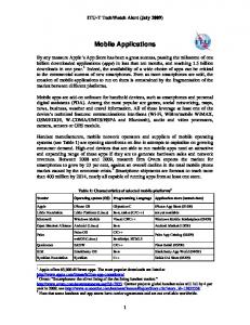
Object access layer and adaptors
HTTP /MAObject
HTTP/XML
Multimap Object
MA Middleware Security Management
Servlets
Beans
Java RMI
MA Objects Space
Mobile application space (MA)
Object metamodel
Object mapping
Object Manipulation
Object Observe
Data Management Notification Management
Object Notification
Object Transformation
Resource Management
Location Management Comunication Management
Web Server Database Management System GIS Server Mail Server
MA Connection Persistence layer
JDBC RDBMS
JNDI Java IDL
LDAP
Messaging Service
Java RMI
Java Mail
MA Java Client Side
MA Java Server Side
Fig.1. Mobile application conceptual architecture With web map components, MC Locator can incorporate map visualization, proximity analysis, location-directed search, and realtime web services into the same infrastructure, and with no greater complexity than what is required for other visualization and analytic tools. Another factor influencing the cost and effort of implementing locationaware business intelligence applications is the expense associated with managing the data itself.
Software architecture include components, connectors and configuration, linked together in a decomposed system, focused on well decomposed set of components with clear responsibilities. Major interest was middleware part, as a adapted solution of collaborative environment, offered by Caramba solution (Dudstar, 2004). Conceptual architecture was divided in four parts: middleware, client side server side (including administration module) and persis-
Economy Informatics, 1-4/2008
tence store, which embedded web server, database management system, GIS server and mail server. Storing position information in a GIS is not suitable solution to large amount of positionseries databases for monitoring vehicle in time. Using a migration solution to MySQL 5.0.38 – as a Database Management System (DBMS) which has a relational and distributed features have some adva ntages including: Standard connectivity tools as ODBC and SQL because most commercial GISs support both technologies and in this case we obtain a portable prototype across multiple GIS platform; Significant reduces of the amount of data that needs to be stored in management model run; Multiple pos sibilities for query results and complex questions usefully in monitoring and opt imization rutes; Capability to store spatial objects and positions ( points, lines, polygons) in explicit mod e rather than coupling in unique ide ntifier with GIS; Spatio-temporary complex queries using DBMS databases (Zerger et all, 2004). Midd leware solution was divided in three layers: Object access layer and adapters, mobile application space as a middleware core, and persistence layer using metamod el framework for manipulation and description of content, and offer flexibility, concurrent remote access at persistence resources, enable customization and extensions, embedded new technology and mobile devices. Object access layer and adapter serves as a access solution at objects and services, depending on client request and observed parameters. By separation between presentation, logical and data stored this layer provide facilities for object observe and notification services and all the customized services are implemented based on object observers and changing positions, given by GIS server and this objects and methods’ implementation. This layer is composed by protocols and standards: HTTP and XML, package and java enterprise features: Java Remote Method
75
Invocation with specific methods implementations, servers and beans for persistence objects and them instances, mobile application objects for auto, positions, maps, and MultiMap Object. Mobile application space provide a shared object space, require a relevant context of information, performed activities and subactivities related with business process and normal and special events appeared. It composed by a object metamodel, and object manipulation, which interact with object mapping and object transformation. As a mobile application, based on position information given by Multimap GIS software, this space include special object: observe and notification. In order to providing functionalities for security and confidential access, remote communications and control, feedback of auto parameters we need several middleware components as: security management, resource management, data management, notification management, location management and communication management. Our prototype solution is based on platform indepe nde nce solution and we chose the Java J2SE programming language with jre 1.5 and Eclipse SDK version 3.2.2 programming environment. Regarding the database, it was built using Database Management System MySQL 5.0.38 – as a relational and distributed solution. Using one of the many schemes available for the MySQL API, we have write a Java applications to access MySQL da tabases. MySQL is an integral component of LAMP platforms or WAMP (Linux / Windows-Apache-MySQL-PHP / Perl /Python). The operating system on wich it was worked was Linux Ubuntu, version 7.4. We used GIS paradigms and exchange data with XML features from MultiMap, and implemented XML Reverse Geocoding service offered by UK MultiMap GIS solution for solving the objective of MC Locator, a monitoring and management application of the auto fleet activities through the use of location and communication equipment based on GPS and GPRS (www.wscomm.com).
76
4. Conclusion The capacity to display and access spatial information of digital globes software and simplicity of use them was a real challenge in communication, making data accessible to a range of users. We focused on digital globes features as a potential for the communication in collaborative companies, especially for monitoring and management application of the auto fleet activities through the use of location and communication equipment based on GPS and GPRS. After we analyzed six major digital globes (Google Earth, NASA World Wind, ESRI ArcGIS Explorer, Skyline Globe and Dapple Earth Explorer, MultiMap UK Microsoft), we mentioned the strengt h and weaknesses of them, than we evaluated potential applicability in our mobile application based on a set of evaluation criteria, according to Aurambout et all. For our prototype we have choose MultiMap UK Microsoft and we developed a conceptual mod el to communicate information and share the results and feedback of auto feet using complex mode ls for operate or access at spatial technologies such as GIS, remote sensing and pos ition and auto parameters visualization of fleet. This paper presents an conceptual architecture, by adapting Caramba model, and was divided in four parts: middleware, client side server side (including administration module) and persistence store, which embedded web server, database management system, GIS server and mail server. Acknowledge ment The paper was supported by the PN II Consortium Grant SIDE and INCOMP. References • [Aurambo ut_07 ] Aurambo ut J-P, Pettit C., Lewis H.,(2007) Virtual Globes: the Next GIS? • [Butler_06] Butler D (2006) The web-wide word. Nature 439:776–778 • [Chrisman_97] Chrisman N., 1997: Exploring Geographic Information Systems. John Wiley & Sons, New York. Colorado University, “Three Different Map Projections” from The Geographer’s Craft, Map Projections
Economy Informatics, 1-4/2008
webpage • [Dimitriu_05] Dimitriu, George (2005), Sisteme informatice geografice GIS, Editura Albastră • [Dustar_04] Schahram Dustdar, Caramba—A Process-Aware Collaboration System Supporting Ad hoc and Collaborative Processes in Virtual Teams in Kluwer Academic Publishers: Distributed and Parallel Databases 15, pp. 45–66, Netherlands, 2004. • [ESRI_03] ]ESRI(2003), ArcPad® StreetMap™: Street-Level Data, Geocoding, and Routing for Mobile Systems, An ESRI ® White Paper • December 2003, ESRI 380 New York • [Gore_98] Gore AA (1998) The digital earth: understanding our planet in the 21st century. California Science Center, Los Angeles • [Hossain_06] Hossain H, Sposito V, Evans C (2006) Sustainable land resource assessment in regional and urban systems. Applied GIS 2:21–24 • [Lisle_06] Lisle RJ (2006) Google Earth: a new geological resource. Geology Today 22:29–32 • [OGC_07] Open Geospatial Consortium, Inc (2007-12-04). "The OGC Seeks Comment on OGC Candidate KML 2.2 Standard". Press release. Retrieved on 2007-1210. • [Rapport_99] Rapport, Theodore S. (1999), Wireless Communication Principle and Practice, Ed. Prentice Hall, , Reprinted with correction • [Riedl_07] Riedl A (2007) Digital globes. In: Cartwright W, Peterson MP, Gartner G (eds),Multimedia cartography. Springer, Heidelberg, pp 255–266 • [Shankland_08] Shankland, Stephen (200804-14). "Google mapping spec now an industry standard". CNET. Retrieved on 2008-0414. • [Smillie_05] Smillie, Donna, (2005), GIS (Geographic Information Systems) and Accessibility, RNIB, September 2005, RNIB Web Access Centre: http://www.rnib.org.uk/wac/ • [Steiner_08] Steiner, J., (2008) Business
Economy Informatics, 1-4/2008
Intelligence and GIS, Systems within Systems, and Ubiquity, How the World Becomes Part of Every Application in the 21s t Century, Business Intelligence Network™, July, 2008 • [Thurston_03] Thurston T., Poiker, T. K., & Moore J. P. (2003). Integrated geospatial technologies: A guide to GPS, GIS and data logging. (New Jersey: Wiley) • [Zerger_04] Zerger Andre, Wealands Stephen 2004 –Beyond Mode lling: Linking Models with GIS for Food Risk Management, Natural Hazard Journal, Kluwer Academic Publisher, pp.191-208 • BBC News- Microsoft Buys UK mapping service, article from 12 December 2007, last access 12.09.2008 • Ecker, Ady - Introduction to GIS Systems, http://gis.esri.com/esriclips/clip.c fm?ClipID= 60 last access 06.06.2008 • Encyclopedia of GIS • EURASIP Journal (2004), Wireless Communication and Networking Volume 2004, No. 1,1 August 2004
77
• http://libraries.mit.edu/guides/subjects/data/ , US Patent Issued on May 2, 2006 • http://www.acada.ro • http://www.colorado.edu/geography/gcraft/ notes/mapproj/mapproj_f.html • http://www.esri.com/arcpadstreetmap, http://www.esri.com/arcpad • http://www.geographynetwork.com, Arc Scene, ArcCatalog, ArcGlobe • http://www.geo-strategies.com • http://www.jonahgroup.com /work/caseStudies/locationsManager.html • http://www.logis.ro • http://www.multimap.com • http://www.wscomm.ro • htttp://www.gisdynamics.com • Multimedia cartography. Springer, Heidelberg, pp 255–266 • Patent 7039640 - System and method for geocoding diverse address formats • Wikipedia (2007) www.wikipedia.org. Retrieved 19 March 2007