Computer Laboratory, University of Cambridge, JJ Thompson Avenue, Cambridge CB3 0FD, United ... On entering an area covered by a wireless access point.
Congestion-Aware Vehicular Traffic Routing Using WiFi Hotspots David N. Cottingham, Jonathan J. Davies, Alastair R. Beresford Computer Laboratory, University of Cambridge, JJ Thompson Avenue, Cambridge CB3 0FD, United Kingdom dnc25,jjd27,arb33 @cam.ac.uk �
http://www.cl.cam.ac.uk/users/dnc25/congestion.html I. I NTRODUCTION
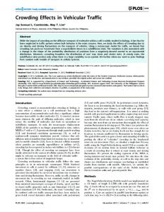
II. S IMULATOR We have extensively modified the SUMO traffic simulator [3] from the German Institute of Transport Research (DLR), to support congestion based routing. As vehicles travel through a city, they record their speeds on each road, which when compared with the roads’ speed limits gives an indication of the degree of congestion. On entering an area covered by a wireless access point (AP), they report this data to the congestion management system. This is combined using a time-weighted averaging mechanism. The AP then transfers updated congestion information to the vehicle concerning all roads that data is available for in the city. This allows route planning to take into account estimated congestion. Currently, we use relatively simple routing algorithms; in future work we will explore more complex schemes as proposed in [4]. Our method differs from existing mechanisms in that very little fixed infrastructure is required, whilst highly accurate and location sensitive information can be obtained, in near real-time. Implementation costs are minimal (compared to e.g. [2]): simply a low cost in-car terminal with a wireless LAN card, along with wireless access points distributed over the city. III. R ESULTS Of particular interest is the effect of access point coverage radius and layout. Figure 1 shows the effect of the system when APs are positioned at junctions. As we vary the
Radius = 10 Radius = 20 Radius = 30 Radius = 40 Radius = 50 Radius = 60
6 % Decrease in Trip Length Time
Congestion on roads in the UK costs the economy an estimated £12 billion a year [1], a figure that is set to rise with increasing commuting distances and distance selling volumes. In cities, congestion on key routes must be managed to ensure smooth traffic flow, even at peak times. We have investigated how vehicles’ routes can be improved by using congestion data collected on the vehicles and distributed by wireless access points. Vehicles exchange data with these access points at regular intervals to provide near real-time information. Our results show that even for a very simple topology (2 route alternatives), the improvements in average journey time can be up to 6%. With more complex cities the benefits will be far more significant.
Percentage Trip Length Time Decrease Varying AP Radius and Alpha at Junctions 6.5
5.5
5
4.5
4
3.5
0
0.2
0.4
0.6
0.8
1
Alpha
Fig. 1.
Effect of congestion management system with APs at junctions.
degree to which historic data is taken into account the effect changes. A low value of alpha signifies historic data is almost ignored. IV. C ONCLUSIONS Our congestion management system yields significant improvements in average journey time, even with very small topologies. Further work includes: The traffic generation model is currently not as realistic as it should be. We expect improving this to increase the efficacy of our system. We intend to implement such a system in the city of Cambridge to validate the conclusions of our simulation. Currently our simulation assumes that all APs can communicate with each other. Implementation of a more decentralised system with limited or completely disconnected APs is a topic for investigation. �
�
�
R EFERENCES [1] R. Devereux, J. Dawson, M. Dix, G. Hazel, D. Holmes, S. Glaister, S. Joseph, C. Macgowan, B. Nimick, M. Roberts, L. Searles, R. Turner, S. Gooding, S. Hickey, and W. Rickett. Feasibility study of road pricing in the UK – report. Technical report, Department for Transport, July 2004. [2] J. Fawcett and P. Robinson. Adaptive routing for road traffic. Computer Graphics & Applications, 20(3):46–53, May/June 2000. [3] D. Krajzewicz, G. Hertkorn, C. R¨ossel, and P. Wagner. SUMO (simulation of urban mobility); an open-source traffic simulation. In Proc. of the 4th Middle East Symposium on Simulation and Modelling, pages 183–187. SCS European Publishing House, September 2002. [4] J. You and T. Y. Kim. Toward developing an expert GIS-Based travel time forecasting model with congestion pattern analysis. Technical report, University of Illinois at Urbana-Champaign & Seoul National University, 1998?