Journal of
Marine Science and Engineering Article
Consensus Ecological Risk Assessment of Potential Transportation-related Bakken and Dilbit Crude Oil Spills in the Delaware Bay Watershed, USA Ann Hayward Walker 1, *, Clay Stern 2 , Debra Scholz 3 , Eric Nielsen 4 , Frank Csulak 5 and Rich Gaudiosi 6 1 2 3 4 5 6
*
SEA Consulting Group, Cape Charles, VA 23310, USA US Fish and Wildlife Service (USFWS), Galloway, NJ 08205, USA;
[email protected] SEA Consulting Group, Charleston, SC 29412, USA;
[email protected] US Coast Guard (USCG), Sector Delaware Bay, Philadelphia, PA 19147, USA;
[email protected] National Oceanic and Atmospheric Administration (NOAA), Emergency Response Division, Highlands, NJ 07732, USA;
[email protected] Delaware Bay and River Cooperative, Inc. (DBRC), Lewes, DE 19958, USA;
[email protected] Correspondance:
[email protected]; Tel.: +1-757-331-1787
Academic Editor: Merv Fingas Received: 16 January 2016; Accepted: 17 February 2016; Published: 7 March 2016
Abstract: Unconventionally-produced crude oils, i.e., Bakken oil and bitumen diluted for transport and known as dilbit, have become prominent components of the North American petroleum industry. Spills of these oils have occurred during transport from production areas to refineries via pipeline, rail, and barge. Some of their physical and chemical properties are distinct and present new challenges in mitigating spill impacts on people and the environment. This paper describes the adaptation of a qualitative risk assessment process to improve spill preparedness and response decisions for these oils when transported in an estuarine area. The application of this collaborative, interdisciplinary process drew upon a literature review, the local knowledge and experience of a broad set of decision makers, practitioners, and technical experts who developed consensus-based recommendations aimed at improving response to spills of these oils. Two emphasized components of this consensus ecological risk assessment (CERA) concerned risks: (1) to human health and safety and (2) from spilled oil and the associated response actions on endangered species. Participants in the process defined levels of concern associated with Bakken and dilbit oils relative to a set of response actions in freshwater, brackish and saltwater habitats and on resources at risk. Keywords: Bakken; bitumen; dilbit; risk assessment; oil spill; response; preparedness; endangered species; threatened species; consensus; human health
1. Introduction Crude oils produced by unconventional methods in North America have become marketable resources used to meet energy demand in the United States (U.S.) and elsewhere. Unconventional crude oils derive from two sources. In the U.S., hydraulic fracturing technologies have been widely applied to extract oil from shale formations or other typically inaccessible, low-permeability rocks. In Canada, petroleum products have been extracted from “oil sands” or “tar sands” [1]. An oil shale formation is a fine-grained sedimentary rock containing a solid material (kerogen) that converts to liquid oil when heated. Oil shale deposits globally occur in 37 countries; the largest and highest quality oil shale deposits are located in sparsely populated areas of Colorado, Utah and Wyoming [2]. Estimated volumes of these oil reserves have increased steadily over the last six years to 39.9 billion barrels in 2014, which represents an increase of 9.3% over the previous year [3]. J. Mar. Sci. Eng. 2016, 4, 23; doi:10.3390/jmse4010023
www.mdpi.com/journal/jmse
J. Mar. Sci. Eng. 2016, 4, 23 J. Mar. Sci. Eng. 2016, 4, 23
2 of 26 2 of 26
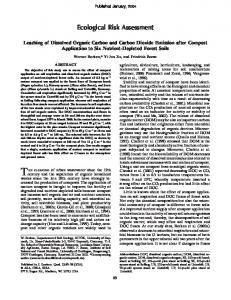
The crude oils produced from oil shale formations and tar sands fields are being transported by The crude oils produced from oil shale formations and tar sands fields are being transported by pipeline, rail, barge and tanker to refineries and market centers (Figure 1). Crude oil with high sulfur pipeline, rail, barge and tanker to refineries and market centers (Figure 1). Crude oil with high sulfur content is referred to as “sour”, while oil with low sulfur content is considered “sweet oil”. Bakken content is referred to as “sour”, while oil with low sulfur content is considered “sweet oil”. Bakken oil is classified as a light, sweet crude oil, which is transported from shale formations to market by oil is classified as a light, sweet crude oil, which is transported from shale formations to market by rail cars [4], often in as many as 100 cars in a single shipment, referred to as a unit train. Bitumen is a rail cars [4], often in as many as 100 cars in a single shipment, referred to as a unit train. Bitumen is a heavy, sour oil derived from oil sand formations in Alberta, Canada. It is a mixture of heavy oil, sand, heavy, sour oil derived from oil sand formations in Alberta, Canada. It is a mixture of heavy oil, sand, clay and water; then separated from the sand and water in a centrifuge. Bitumen is mixed with about clay and water; then separated from the sand and water in a centrifuge. Bitumen is mixed with about 30% of diluents in order to decrease viscosity and facilitate flow during transportation via pipeline; it 30% of diluents in order to decrease viscosity and facilitate flow during transportation via pipeline; is known as diluted bitumen, or “dilbit”. When transported by rail, bitumen is diluted about 15% with it is known as diluted bitumen, or “dilbit”. When transported by rail, bitumen is diluted about 15% awith a diluent and then known as “railbit” [5]. diluent and then known as “railbit” [5].
Figure 1. Major rail transportation arteries for oil across North America [4]. Figure 1. Major rail transportation arteries for oil across North America [4].
Recent transportation‐related incidents have resulted in spills of these unconventional crude oils Recent transportation-related incidents have resulted in spills of these unconventional crude oils (Table 1). Bakken and dilbit oils exhibit some properties which present distinct issues for emergency (Table 1). Bakken and dilbit oils exhibit some properties which present distinct issues for emergency responders. Bakken oils are highly volatile and soluble in water. Accidents involving unit trains that responders. Bakken oils are highly volatile and soluble in water. Accidents involving unit trains are transporting Bakken oil have led to serious fires and loss of life. Dilbit oil is heavy crude oil. that are transporting Bakken oil have led to serious fires and loss of life. Dilbit oil is heavy crude oil. Compared to medium or light crude oils, it is characterized by exceptionally high density, viscosity, Compared to medium or light crude oils, it is characterized by exceptionally high density, viscosity, and adhesion properties from the bitumen component of the diluted bitumen. For both these crude and adhesion properties from the bitumen component of the diluted bitumen. For both these crude oils, these properties affect weathering behavior (physical and chemical changes of spilled oil from oils, these properties affect weathering behavior (physical and chemical changes of spilled oil from its its initial release over time) in the environment, especially when dilbit is spilled into waterways. initial release over time) in the environment, especially when dilbit is spilled into waterways.
J. Mar. Sci. Eng. 2016, 4, 23
3 of 26
Table 1. Examples of recent transportation-related incidents involving spills of dilbit and Bakken crude oil [6–14]. Description
Volume
Comments
Dilbit Oil ‚
June 2010—Marshall, Michigan, USA
Enbridge Energy Partners Limited Liability Partnership‘s (Enbridge) 30-inch pipeline ruptured releasing its contents, i.e., dilbit (report to the National Response Center was 19,500 bbls) into a culvert leading to the Tallmadge Creek, a tributary of the Kalamazoo River. The oil sank to the river's bottom and collateral damage resulted from recovery tactics.
‚
‚ ‚
March 2013—Mayflower, Arkansas, USA
ExxonMobil’s 20-inch “Pegasus Pipeline” ruptured near Mayflower, Arkansas. Approximately 5000 bbls of dilbit (Canadian Wabasca heavy crude oil from the Athabasca oil sands) spilled into the surrounding area and flowed into Lake Conway.
‚ ‚ ‚ ‚ ‚
The Kalamazoo River is bordered by marshland and developed properties for the approximate 30-mile stretch of the response site Variety of tactics to collect the oil: spraying the sediments with water, dragging chains through the sediments, agitating sediments by hand with a rake, and driving back and forth with a tracked vehicle to stir up the sediments and release oil trapped in the mud Approximately 62 homes evacuated Wetland vegetation, waterfowl and various other wildlife were impacted Personnel on Site (250 in Command Post/440 in Field) 663 ExxonMobil personnel and contractors 23 Vacuum Trucks 85 Frac tanks 9593 ft. Hard Boom and 241,290 ft. of Soft Boom
Bakken Oil
April 2014—Lynchburg, Virginia, USA
A CSX train carrying Bakken crude oil in a 105-car train, jumped the rails causing 13-unit cars to derail and some were damaged. The derailment sparked a large fire that forced the evacuation of six city blocks; 3 cars submerged in the James River, and 30,000 gals of oil were released.
‚ ‚ ‚ ‚
‚ ‚
February 2014—Mississippi River, Louisiana, USA
The Tank Barge E2MS 303 collided with the towboat Lindsay Ann Erickson on the Lower Mississippi River (between Baton Rouge and New Orleans), causing a spill of approximately 750 bbls (31,500 gals) of Bakken oil.
‚
‚
‚
No fatalities or injuries Fire permitted to burn Soil and vegetation was coated with crude oil 17-mile oil slick in the James River 65-mile closure of the Lower Mississippi River for 2 days Total oil recovered: 95 gals (2.3 bbls) Reports of high concentrations of benzene vapors during lightering operations Approximately 150 personnel responding to this incident including federal, state, local, and industry representatives. No reports of oiled or injured wildlife
J. Mar. Sci. Eng. 2016, 4, 23
4 of 26
Table 1. Cont. Description
Volume
November 2013—Aliceville, Alabama, USA
90-car train was crossing a timber trestle above a wetland near Aliceville late Thursday night when approximately 25 rail cars and two locomotives derailed, spilling Bakken crude oil into the surrounding wetlands and igniting a fire that was still burning Saturday. Each of the 90 cars was carrying 30,000 gals of oil; 630,000 gals were either spilled or burned.
July 2013—Lac-Megantic, Quebec, Canada
Runaway train derailed (insufficient hand breaks) with 63 rail cars (30,000 gals each). Approximately 1.7 million gals of Bakken oil either burned or was released, with an estimated 26,000 gals into the Chaudière River.
Comments
‚ ‚ ‚ ‚ ‚
‚ ‚ ‚ ‚
21 cars were in marsh habitat Significant fire permitted to burn No fatalities or injuries Response hampered by lack of access in remote area Significant impact to wetlands
Massive fire in town center 47 residents were killed Over 70 buildings destroyed River restricted to non-drinking water status
To improve response capabilities to potential incidents, emergency response decision makers throughout the USA, Canada, and the European Union have studied these past oil spills and prepared recommendations for their respective jurisdictions [15–29]. In the USA, the USA Coast Guard (USCG) is the lead federal authority for oil spill response decisions in coastal areas; the US Environmental Protection Agency (EPA) is the lead federal authority for inland areas. USCG and EPA lead response officials are the designated Federal On-scene Coordinators (FOSCs). Other government agencies and stakeholders, including potentially responsible parties, have roles in oil spill preparedness and response as described in Subparts B and C of the National Oil and Hazardous Substances Pollution Contingency Plan, referred to as the NCP [30]. The increase in production of these unconventionally-derived oils has resulted in changes in the transportation patterns and in oil spill risks in the coastal zone [31], to which the USCG has turned its attention. The USCG is a multi-mission agency, charged with enforcing various laws and regulations and protection of maritime economy, the environment and ultimately providing for the well-being, general safety, security, and interests of the citizens of the United States. In this regard, the USCG must consider and manage potential risks to transportation safety and the marine environment from pollution. A variety of risk assessment approaches are available; for example the NEREIDs [32] supported by cooperation of marine research centers in Greece, Cyprus and the United Kingdom, along with a multinational incident report database advances cross-border civil protection and marine pollution cooperation for direct response to natural and man-made disasters. Modeling of oil spills in confined maritime basins using bathymetric and geomorphic data has been used to identify risks to vulnerable and sensitive coastlines [28,29,33]. In 1998, Aurand [34] proposed adapting EPA’s Ecological Risk Assessment (ERA) approach, which was first developed in 1992 to assess ecological effects caused by human activities, for use in oil spill planning [35]. The goal was to facilitate resolution of disagreements over the potential risks and benefits of alternative response technologies, i.e., dispersants and in-situ burning, compared to traditional mechanical containment and recovery actions. In 1998, the concept was put into practice for the first time in a set of meetings in the Puget Sound area [36]. This initial effort clearly demonstrated the need for, and challenges with, reconciling concerns among environmental response professionals with diverse expertise and responsibilities about which response actions would have the lowest collateral damage and would reduce the risks of impacts from spilled oil. The situation was more complex than just committing to the use of ecological risk assessment methods to overcome skepticism and concerns about the environmental risks of using dispersants and in-situ burning in addition to mechanical recovery during oil spill response. Based on the Puget Sound ERA, the process was revised to place more emphasis on facilitated risk communication and qualitative risk assessment, and less emphasis on attempts to quantify the details related to a hypothetical event. The revised
J. Mar. Sci. Eng. 2016, 4, 23
5 of 26
process, which emphasizes reaching agreement among the risk management team, stakeholders, and interested parties, has been referred to as a Consensus Ecological Risk Assessment (CERA). The USCG developed a guidebook for conducting CERAs [37] and over a dozen have been carried out. Briefly, the CERA requires a collaborative, multi-disciplinary exchange and application of scientific findings from currently available literature in addition to local knowledge, and direct experience of risk managers (spill decision makers), resource agency managers and scientists (risk assessors), and other interested parties. The process involves a comparison of the anticipated impacts of spilled oil to the potential mitigation of impacts by various response actions with their associated collateral damages. The objective is to identify those response actions which are most likely to mitigate overall spill risks on people and the environment, that is, improve the outcome over letting the oil attenuate naturally. Building upon the process used in previous CERAs, the USCG FOSC for Sector Delaware Bay initiated a CERA in 2014 with the aim of improving preparedness and response to potential transportation-related spills of Bakken and dilbit crude oils in the Delaware Bay watershed. The changing energy landscape and associated risks to ecological resources necessitates a whole-of-community approach to improving preparedness and response to spills of these crude oils. The focus of this paper is the adaptation of the USCG CERA to evaluate a different set of response actions than previous CERAs for spills involving Bakken and dilbit, which have become part of the USCG’s evolving responsibilities in the recent domestic energy renaissance, particularly in the Delaware Bay Watershed. This work incorporates a new emphasis to address potential risks to US federal- and state-listed threatened and endangered (T/E) species. An overview of the CERA process is presented in the Methods Section. The Discussion Section describes noteworthy adaptations by the Project Committee of important components in the process, i.e., resources of concern, response actions, conceptual model, levels of concern, that were used to characterize the potential risks to people and the environment from transportation-related spills of Bakken and dilbit oils. The project report contains a detailed description of this work [38]. 2. Methods The USCG Guidebook describes details for conducting a CERA for a marine oil spill [37]. Applications of earlier CERAs are discussed elsewhere [39–41] and are similar to those implemented in the NEREIDs [32] project in Europe. This CERA was consistent with the 12 activities, carried out in four phases, as described in the USCG Guidebook (Figure 2). The CERA process was guided by a Project Committee, comprised of agency representatives in the study area from the USCG, EPA, National Oceanic and Atmospheric Administration (NOAA), U.S. Fish and Wildlife Service (USFWS), the States of Delaware (DE), Pennsylvania (PA), and New Jersey (NJ), an Oil Spill Response Organization (OSRO) and the consultancy firm responsible for carrying out the work. Many previous CERAs that were conducted using the USCG Guidebook were reviewed as background for this project, along with a broad review of the relevant literature, access to which was provided to all participants on a SharePoint site. A USCG objective in this CERA was also to consider risks to T/E species in accordance with USCG headquarters guidance [42], and pursuant to Endangered Species Act (16 U.S.C. 1531–1544, 87 Stat. 884) Section 7(a) (1–2) and Essential Fish Habitat under the Magnuson-Stevens Fisheries Conservation and Management Act.
J. Mar. Sci. Eng. 2016, 4, 23 J. Mar. Sci. Eng. 2016, 4, 23
6 of 26 6 of 26
PHASE 1: Problem Definition/Formulation 1. Assemble the Project Committee 2. Develop the scenario(s) 3. Estimate the transport, fate of oil, and exposure potential 4. Define response actions for consideration 5. Define resources of concern PHASE 2: Conceptual Model/Analysis Plan (All participants, Workshop 1) 6. Consider important relationships 7. Thresholds of sensitivity to oil PHASE 3: Analysis and Risk Characterization (All participants, Workshop 2) 8. Determine levels of concern about effects 9. Evaluate relative risk for oil only vs. various response actions 10. Define limits of the analysis PHASE 4. Document and Apply (Project Committee) h
k
Figure 2. Consensus Ecological Risk Assessment process for oil spills. Figure 2. Consensus Ecological Risk Assessment process for oil spills.
2.1. Risk Analysis and Characterization 2.1. Risk Analysis and Characterization The risk analysis and characterization was conducted two, two-day workshops, The risk analysis and characterization was during conducted during interactive two, two‐day interactive separated by about two weeks. The scope of this CERA was considerably more complex than that workshops, separated by about two weeks. The scope of this CERA was considerably more complex in previous CERAs. For thisCERAs. reason, For the this Project Committee developed in advance and in presented than that in previous reason, the Project Committee developed advance and many presented of the outputs of activities 2–7 (Figure 2) to workshop participants for their consideration many of the outputs of activities 2–7 (Figure 2) to workshop participants and for their finalization. A total of 88 participants provided their input. They represented the following groups consideration and finalization. A total of 88 participants provided their input. They represented the of stakeholders: USCG; of EPA; US Department of EPA; the Interior; USFWS; NOAA; Federal Emergency following groups stakeholders: USCG; US Department of the Interior; USFWS; NOAA; Management Agency; Agency for Toxic Substances and Diseases Registry; the States of PA, NJ, and Federal Emergency Management Agency; Agency for Toxic Substances and Diseases Registry; the DE; City of Philadelphia; Delaware County, PA; Fire Departments of County, Philadelphia States of PA, NJ, and DE; City of Philadelphia; Delaware PA; and Fire Eddystone, Departments of PA; academia; non-governmental organizations (NGOs); oil spill responders; and rail and(NGOs); petroleum Philadelphia and Eddystone, PA; academia; non‐governmental organizations oil spill industries. Participants were assigned to scenario-specific workgroups to reach consensus about the responders; and rail and petroleum industries. Participants were assigned to scenario‐specific relative risk characterizations for five pre-determined scenarios. They also met in plenary at workgroups to reach consensus about the relative risk characterizations for five sessions pre‐determined the beginning and end of each day for group presentations, briefings, and discussion of their respective scenarios. They also met in plenary sessions at the beginning and end of each day for group findings. Drawing onbriefings, the collective knowledge of a cross-section of the local oil spill presentations, and experience discussion and of their respective findings. Drawing on the collective response community, the participants qualitatively evaluated the adverse ecological impacts of spilled the experience and knowledge of a cross‐section of the local oil spill response community, oil andparticipants qualitatively evaluated the adverse ecological impacts of spilled oil and spilled oil plus spilled oil plus an evaluated response action to predict the severity and duration of adverse impactan toevaluated natural resources in action a givento scenario. response predict the severity and duration of adverse impact to natural
resources in a given scenario. 2.2. Study Area The geographic area of concern for this CERA encompassed the coastal zone, a portion of the 2.2. Study Area USCG area of responsibility in the Delaware Bay Estuary in the mid-Atlantic region of the US (Figure 3), The geographic area of concern for this CERA encompassed the coastal zone, a portion of the that included marine (coastal bay), brackish (coastal river) and freshwater habitats (inland river). The USCG area of responsibility in the Delaware Bay Estuary in the mid‐Atlantic region of the US Delaware Bay region is a nationally and internationally important natural resource and is a critical (Figure 3) , that included marine (coastal bay), brackish (coastal river) and freshwater habitats (inland component of U.S. energy independence which ultimately contributes to national security. According river). The Delaware Bay region is a nationally and internationally important natural resource and is to the U.S. Energy Information Administration (EIA), crude by rail movements of Bakken and dilbit a critical component of U.S. energy independence which ultimately contributes to national security. to the mid-Atlantic region have increased from 1000 barrels per day (BPD) in 2010, to 800,000 BPD According to the U.S. Energy Information Administration (EIA), crude by rail movements of Bakken in 2014 (Figures 4 and 5), including the Delaware Bay region in 2014. and dilbit to the mid‐Atlantic region have increased from 1000 barrels per day (BPD) in 2010, to 800,000 BPD in 2014 (Figures 4 and 5), including the Delaware Bay region in 2014.
J. Mar. Sci. Eng. 2016, 4, 23 J. Mar. Sci. Eng. 2016, 4, 23 J. Mar. Sci. Eng. 2016, 4, 23 J. Mar. Sci. Eng. 2016, 4, 23
7 of 26 7 of 26 7 of 26 7 of 26
Figure 3. Locations of the five scenarios. Inset shows the location of the study area—the Delaware Bay Figure 3. Locations of the five scenarios. Inset shows the location of the study area—the Delaware Bay Figure 3. Locations of the five scenarios. Inset shows the location of the study area—the Delaware Bay Figure 3. Locations of the five scenarios. Inset shows the location of the study area—the Delaware Bay estuary in the mid‐Atlantic region of the US. estuary in the mid-Atlantic region of the US. estuary in the mid‐Atlantic region of the US. estuary in the mid‐Atlantic region of the US.
Figure 4. Crude‐By‐Rail Movements of Bakken and dilbit in 2010, tracked by Petroleum Administration Figure 4. Crude-By-Rail Movements of Bakken and dilbit in 2010, tracked by Petroleum Administration Figure 4. Crude‐By‐Rail Movements of Bakken and dilbit in 2010, tracked by Petroleum Administration Figure 4. Crude‐By‐Rail Movements of Bakken and dilbit in 2010, tracked by Petroleum Administration for Defense District (PADD) regions [43]. for Defense District (PADD) regions [43]. for Defense District (PADD) regions [43]. for Defense District (PADD) regions [43].
Figure Crude‐By‐Rail Movements of and dilbit in tracked by Figure 5.5. 5. Crude‐By‐Rail Movements of Bakken Bakken and dilbit in 2014, 2014, tracked Administration by Petroleum Petroleum Figure Crude-By-Rail Movements of Bakken and dilbit in 2014, tracked by Petroleum Figure 5. Crude‐By‐Rail Movements of Bakken and dilbit in 2014, tracked by Petroleum Administration for Defense District (PADD) regions [44]. for Defense District (PADD) regions [44]. Administration for Defense District (PADD) regions [44]. Administration for Defense District (PADD) regions [44].
The Delaware Bay Estuary is regarded internationally as ecologically valuable, designated as a The Delaware Bay Estuary is regarded internationally as ecologically valuable, designated as a Wetland Wetland of of International International Importance Importance by by the Ramsar the Ramsar Convention. Convention. In May 1986, In May 1986, Delaware Delaware Bay Bay was was recognized as the first Western Hemisphere Shorebird Reserve Network (WHSRN) recognized as the first Western Hemisphere Shorebird Reserve Network (WHSRN) Site Site of of
J. Mar. Sci. Eng. 2016, 4, 23
8 of 26
The Delaware Bay Estuary is regarded internationally as ecologically valuable, designated as a Wetland of International Importance by the Ramsar Convention. In May 1986, Delaware Bay was recognized as the first Western Hemisphere Shorebird Reserve Network (WHSRN) Site of Hemispheric Importance for migrating shorebirds, and is considered the most important spring stopover in the eastern USA for several species of shorebirds [45]. Using natural capitalization valuation methods, estimates of the value of natural goods and ecological services provide by the Delaware Bay Estuary watershed exceeded $10 billion per year [46]. 2.3. Transportation Scenarios The Project Committee considered locally-probabilistic scenarios to define the risk situation as the basis for subsequent activities. In this case, five scenarios reflecting representative transportation patterns, risks of interest to local and regional stakeholders, and response considerations, e.g., response times and efficacy of response actions were defined. Variables between scenarios included: waterway type, (urban (river) and more rural (bay and creek) environments; transportation mode (rail, barge and tanker) seasonal differences (winter and spring) to address the differences in response actions and sensitivity of resources of concern. The locations of the five scenarios are shown in Figure 3. Scenarios 1–3 involved spills of Bakken oil from rail cars (Scenario 1), a barge (Scenario 2), and a tanker (Scenario 3); Scenarios 4–5 involved spills of dilbit oil from rail cars (Scenario 4) and a barge (Scenario 5). 2.4. Threatened and Endangered Species During an oil spill, as matter of federal law, the FOSC is required to consult with the appropriate federal resource agencies to ensure that the response actions taken are not likely to jeopardize the continued existence of any federally-listed threatened or endangered species or result in the destruction or adverse modification of habitat of such species. In the USA, animal or plant species of conservation concern may be listed as threatened or endangered under the USA Endangered Species Act (federally-listed species). A federal listing means that a species is in decline throughout its entire range which may encompass several other states or nations. Individual states have the authority to list a species of conservation concern (state-listed species), but this listing only addresses species status within that state. As such, species may be listed as state threatened or endangered and not be federally listed. Therefore, for the conservation benefit of state-listed species, the participants came to consensus early in a process that state-listed species would be given extra consideration similar to that afforded by law to federally-listed species throughout the CERA. In doing so, participants were galvanized towards using their individual and collective authorities in carrying out the CERA to proactively further the conservation of threatened and endangered species independent of whether the species was federally or state listed. For the purposes of this CERA, use of the term “T/E species” is inclusive of federal and state-listed species. Example T/E plants and animals in the study area included among others: ‚ ‚ ‚ ‚ ‚ ‚
Mammals—northern long-eared bat, Birds—red knot and least bittern (shorebirds), Amphibians—southern leopard frog, Fish—Atlantic sturgeon, short-nose sturgeon, hickory shad, banded sunfish, Reptiles—eastern redbelly turtle, and Plants—long-lobed arrowhead, wild rice, and seabeach amaranth.
3. Results Participants acting in the roles of risk managers, risk assessors, or other interested and affected stakeholders, characterized the potential ecological and human health and safety risks of the five scenarios. The findings in this CERA summarize the workgroup-specific consensus for each of five
J. Mar. Sci. Eng. 2016, 4, 23
9 of 26
scenarios, rather than consensus of all participants for all five scenarios. When spilled, Bakken and dilbit behave differently. Moreover, the behavior of dilbit oils can vary depending upon the type and percentage of added diluents. For Bakken oils, participants agreed that the primary initial strategy is to safely mitigate risks from flammable vapors. For dilbit oils, participants determined that it is imperative for containment and skimming operations to be implemented immediately to recover the oil before it spreads, weathers, begins to pick up any sediments in the water, and possibly would begin to sink. However, in developing response strategies during the initial hours of a spill, responders must also consider health and safety hazards of the oils, i.e., evaporation of light ends, release of hydrogen sulfide gas, and flammability, especially with regard to ignition sources, e.g., boat engines. In this CERA, participants assigned higher levels of concern about the ecological risks associated with a spill of dilbit oil compared to a spill of Bakken crude oil. The adaptation of the CERA process, to provide a structured way to qualitatively assess the potential risk from transportation-related spills of Bakken and dilbit oil in the coastal zone of the Delaware Bay estuary, was successful. It enabled the interdisciplinary collaboration of risk managers (spill decision makers and resource managers), assessors (agency and academic scientists, responders) NGOs and other stakeholders to reach consensus about the relative risks of the spilled oil compared to a set of response actions on resources of concern, including T/E species. This consensus represents guidance for the lead federal official, i.e., USCG FOSC, about response actions which should be taken to mitigate pollution risks from these oils. Actions to mitigate the public health and safety risks in the early stages of the emergency, especially from rail incidents near populated areas, would remain the responsibility of first responders, e.g., fire fighters. The CERA process, as conducted, was interdisciplinary. It promoted and enabled the transparent integration of information, data, techniques, tools, perspectives, concepts, and/or theories from multiple disciplines or bodies of specialized knowledge to solve problems such as mitigating human health and ecological risks from transportation-related spills of two unconventional crude oils, whose solutions are beyond the scope of a single discipline or area of research practice. As such, this CERA was consistent with the findings of a study that established a consensus of building principles for a landscape approach to reconciling conservation with other competing land uses [47]. The CERA process was designed as a planning and educational tool to enable thoughtful, comprehensive assessment of potential risks. It is not designed, nor intended, to be implemented real-time during response. Notwithstanding, the knowledge and experience gained by the participants facilitates real-time decision-making among risk and resource managers if an actual spill occurs in the same geographic area because the detailed reasoning process of potential risks and benefits of response actions remains relevant, even when the specific details of the situation are different. Further, the process gives equal opportunity to all participants to provide input into the risk characterization. This aspect of the CERA cultivates and strengthens mutually-beneficial working relationships and, when consensus is reached, builds trust that the chosen response actions are the appropriate ones to mitigate ecological and human health risks. The process recognized that the many values and services provided by the resources of concern are, to some degree, measured by the judgement of resource managers, and other stakeholders, not as simply by an instrument reading or other singular metric. This qualitative risk assessment considered conservation of the Delaware Bay that allows multiple uses of the waterways as legitimate, i.e., that conservation of the creeks, river, and bay is important for transportation, commerce and recreation, and as habitat for wildlife. Participants also concluded that there were important gaps in the available information to resolve their questions and concerns around the use of firefighting foam to mitigate fire risks for public health and safety that could potentially present substantive or even unacceptable ecological risks. They advocated that the response community, working with industry, develop recommendations for a holistic “concept of operations” approach for dilbit oil spills that is, define a priority sequence of response actions to implement near the spill source. For example, pre-spill planning should focus on
J. Mar. Sci. Eng. 2016, 4, 23
10 of 26
improving the effectiveness of oil containment and recovery in the early stages of a spill. The best option to minimize the ecological risk of dilbit oils using currently available technology is to deliver containment and recovery equipment quickly to the scene to limit the geographic spread of oil and recover the majority of spilled oil before it becomes sufficiently weathered to sink, thereby impeding detection and recovery. In a creek, skimming would be the primary strategy to recover the oil and limit the extent of its movement and contamination, i.e., before the oil could move into the river and become much more difficult to recover. 4. Discussion The consensus-building approach clearly enabled the diverse members of the Project Committee to broadly consider and work toward a common goal. This collaboration was built on mutual respect for one another’s respective specialties, knowledge and responsibilities. In working through this transparent process, participants developed trust in one another’s judgements. While the context of this project was an emergency caused by an oil spill, the same stakeholders would be involved in mitigating human health and environmental hazards associated with other emergencies, e.g., extreme weather or terrorism events. In this regard, this CERA added value to all-hazard preparedness in the Delaware Bay Watershed. Working together, the Project Committee developed new CERA components for assessing risks from transportation-related Bakken and dilbit spills, described below. While the percentage of diluents added to bitumen varies for rail and pipeline transportation, the weathering behavior is the same and therefore this CERA considers dilbit as generally representative of diluted bitumen. 4.1. Resources of Concern The habitats for the scenarios spanned freshwater (Scenarios 1 and 4), brackish water (Scenarios 2 and 3), and saltwater environments (Scenario 5). Resources of concern were identified for these environments using the structure presented in Table 2. Generally, the categories identified in Table 2 provided the participants a common framework that would be applied to each scenario. The list of potential resources of concern and at risk in the five scenarios were grouped according to habitat, sub-habitat, and resource categories. The presence of T/E species varied on a scenario-specific basis. Table 2. Organization of resources of concern and at risk from Bakken and dilbit oil spills in marine, brackish water, and freshwater environments in a temperate climate in the mid-Atlantic coast of the USA, encompassing Delaware Bay. Habitats: ‚ ‚ ‚ ‚ ‚
Artificial shorelines Natural terrestrial shorelines Intertidal shorelines (including surface waters 0–1 meter) Mid-water (0–2 meters from the surface, but above the bottom 2 meters) Benthic (bottom + 2 meters)
Sub-habitats: ‚ ‚ ‚ ‚ ‚ ‚ ‚
Bulkheads, riprap, man-made structures, pavement Vegetated, sand, gravel Marsh, swamp, tidal flats Water column Seabed Socio-economic resources Human health receptors
J. Mar. Sci. Eng. 2016, 4, 23
11 of 26
Table 2. Cont. Categories of Ecological Resources of Concern: ‚ ‚ ‚ ‚ ‚ ‚ ‚ ‚ ‚
Mammals (aquatic and non-aquatic dependent) Birds (aquatic and non-aquatic dependent) Reptiles and amphibians (aquatic and non-aquatic dependent) Macro-invertebrates Aquatic vertebrates T/E species—Animals T/E species—PlantsPlants (submerged and floating aquatic vegetation) Fishing (commercial and recreational) Water intakes (surface and mid-water)
Categories of Socio-economic Resources of Concern: ‚ ‚ ‚ ‚ ‚ ‚
Workers Residential community Sensitive receptors Commercial community Industrial community Transportation community
Because these oils present public safety risks when initially spilled, human health and safety risks also needed to be considered, especially in populated areas, i.e., urban areas and mass transportation corridors. Risks to human health were considered for groups of socio-economic resources of concern, including workers as well as the general public, also in Table 2. 4.2. Response Actions The Project Committee considered practical categories of currently available response actions that could be implemented during response to spills involving these oils, as well as their logistics limitations, and effectiveness considerations. The potential collateral damages that could result from implementing these response actions (e.g., physical trauma to organisms and habitats from shoreline cleanup, underwater recovery or physical contact methods of oil detection) were considered in the development of the conceptual models for each scenario, which identified the ways in which resources of concern could be exposed to potential hazards associated with the oil and response actions. Response to spills of these crude oils involves two weathering timeframes: the initial flammability phase when light ends of the oils are present and fires could occur, during which the deployment of traditional spill response options would be pre-empted by first responder (fire fighter) actions; and the second, longer-term phase of responding to the oil on-water. For purposes of this CERA, pollution responders could become actively engaged in the initial 4–6 h after first responders (e.g., fire fighters) would have arrived on scene and might still be dealing with flammability risks. Recent incidents have resulted in significant fires involving Bakken oil, which has been known to re-ignite. Flammability is also a concern with freshly-spilled dilbit oil. During this emergency phase, public safety actions would take precedence over pollution response actions. The behavior of the oil will begin to change due to weathering after the initial 4–6 h. Next, the CERA considers the weathered oil behavior approximately four to seven days after the emergency phase during which oil could still be found on the water surface and be recoverable using traditional pollution response techniques. Toward the end of this timeframe, the residual bitumen component of dilbit oil would likely begin to pick up sediment in the water column and sink below the water surface, either in the water column or settle on the bottom. The time scales associated with response actions are not absolute; rather they represent a range of hours and days that generally align with important oil weathering and behavior changes that ultimately would influence decisions about potential response actions.
J. Mar. Sci. Eng. 2016, 4, 23
12 of 26
For both of these crude oils, oil recovery on-water is difficult after the oil weathers. Bakken oil is a light crude oil; following rapid evaporation of light ends, the remaining components naturally disperse into the water column, making recovery from the water generally impractical. Dilbit oil, on the other hand, is comprised of heavy oil tar sands mixed with diluents to facilitate its transportation. When initially spilled, the light fractions in the diluted bitumen begin to evaporate. After a few days, residual heavier components may be exposed to sediments in the water column and no longer float, making it more difficult to track and recover. The following categories of response actions were used in assessing the risks associated with responding to Bakken and dilbit oil spills in the five transportation-related scenarios: 1. 2. 3. 4. 5. 6. 7. 8. 9. 10.
Natural attenuation with monitoring (NAM) Fire—Let burn and controlled burn (both in-situ) Fire—Extinguishing agent and methods No Fire—Vapor suppression No Fire—Oil spread control (on-land, on-water, and underwater) No Fire—On-water recovery and underwater recovery No Fire—Resource protection (on-water and on-land) No Fire—Shoreline clean-up No Fire—Oil detection/mapping (physical-contact methods) No Fire—Oil detection/mapping (remotely-observed methods)
The overall list was categorized to better align with the response categories of previous ERAs and to facilitate evaluating their risks. These general categories provided a common framework for the workgroup participants since specific response actions could vary among the five scenarios, e.g., some on land, some on water, and presence or absence of ice. The following section defines each possible response action and lists some points regarding logistical considerations, limitations, and considerations that influence its effectiveness in mitigating threats presented by spilled Bakken and dilbit oil. During the risk characterizations, participants discussed additional, more detailed aspects of the response actions. 4.2.1. Natural Attenuation and Monitoring (NAM) Natural attenuation relies on natural processes to decrease or “attenuate” concentrations of contaminants (oil) in soil, groundwater, and water. NAM can also be used when the oil is not recoverable, more environmental damage will occur from the response actions, or effective spill response resources are not available. NAM may require extensive monitoring via sampling and other methods, a network of trained observers, detailed sampling protocols, and other unique underwater sampling methods for sinking oils (e.g., dilbit crude oil if it sinks after the majority of light fractions evaporate). Monitoring typically involves collecting soil, groundwater, and water samples to analyze them for the presence of contaminants (oil) and other site characteristics. Some limitations/complications of NAM include: difficulty locating/tracking dilbit if it sinks, potential significant substrate environmental impact if residual dilbit oil sinks, fisheries closings, and public dissatisfaction with the oil spill response. The effectiveness of NAM depends on a multitude of factors such as oil type, ambient weather, and other environmental considerations. Attenuation may be most prudent for Bakken crude oil. Because dilbit is more persistent, it may not be a good candidate for attenuation on land. In responses involving NAM, monitoring would be required (visual monitoring at a minimum) for both oil types; long-term monitoring of spilled oil is most effective and practical on land, compared to a spill in water. 4.2.2. Fire—Let Burn and Controlled Burn (both In-situ) Allowing product to burn in-situ is another possible response action. Given the five scenarios, CERA participants considered allowing rail cars to burn themselves out, or control the burn to
J. Mar. Sci. Eng. 2016, 4, 23
13 of 26
reduce environmental impacts of the spilled oil. Although (intentional) controlled burning in situ was discussed and remained as an option, fire boom would have to be available and the logistics and regulatory approval could preclude its implementation. Air quality issues play a significant role with intentionally burning Bakken oil, e.g., concerns about breathing in the toxins that are in the resultant smoke plume. Example logistical considerations for this response action that must be addressed include: ‚ ‚ ‚ ‚
How and where to obtain and apply water-cooling streams? Are current fireboats sufficient and able to respond? Can first responder and public safety air monitoring be deployed? Can adequate protection of exposed structures be attained?
Potential limitations of this response action include sufficient access to water supply, frac tanks, high-flow fire pumps and nozzles. The effectiveness of this response action is highly dependent upon the ability to get close enough for effective water cooling, as there is a great potential for “heat-induced tear” in the rail car's shell resulting in a rapid release of vapor and violent fire. 4.2.3. Fire—Extinguishing Agent and Methods This response action includes the strategies and tactics that use extinguishing agents, including firefighting foam, and the people, equipment and other resources used to extinguish a crude oil fire. Extinguishing agents put a fire out by disrupting one of the four pieces of the fire tetrahedron. Logistical considerations include foam availability and applicability given the incident-specific conditions and consideration of adjacent rail cars or shipboard tanks that must be addressed when utilizing extinguishing agents. Some limitations of using extinguishing agents include: ‚ ‚ ‚ ‚ ‚
The ability to access, in a timely manner, Sufficient quantity of foam and water, Dry chemical agents, Fire boom, and Fire boats with the necessary high-volume fire pumps and nozzles.
Additionally, fighting crude oil fires requires highly skilled and specialized personnel. This response action is very effective if the required resources arrive quickly, and the methods are applied properly to the developing situation. This is especially critical before adjacent rail cars are heated to the point of shell plate failure and catch fire. 4.2.4. No Fire—Vapor Suppression This strategy uses vapor suppression agents, i.e., firefighting foam, to reduce and/or blanket the vapors being released from pooled crude oil in order to reduce the risk of fire and to provide a safe working environment for the first responders and the surrounding public. Examples of logistical considerations include sufficient quantity of foam, regulated products under Subpart J of the NCP (such as herding agents and encapsulators), absorbents, intrinsically-safe vacuum pumps/trucks, personal protective equipment (PPE), and air monitoring equipment. This strategy is not without limitations, because the application of firefighting foam on waters of the US, and where the runoff would enter navigable waters, involves water pollution regulatory issues. Additionally, depending upon the scenario and amount of product spilled, a large coverage area may be required to suppress the vapors. This response action is effective for pooled crude oil in containment (e.g., oil contained by boom, drainage ditch, or small creek). 4.2.5. No Fire—Oil Spread Control (On-Land, On-Water, Underwater) This response action includes the strategies and tactics that control the spread of oil, and the people, equipment and other resources used to contain the oil. Examples of this strategy include
J. Mar. Sci. Eng. 2016, 4, 23
14 of 26
containment and/or deflection boom, sorbents, pneumatic curtains, turbidity curtains, dams/dikes, interceptor trenching, underflow dams, and pre-staged boom. Some limitations of utilizing this action include ensuring a sufficient quantity of boom, sorbents, and other materials given the amount spilled, current weather conditions, and the type of product. Additionally, the speed of deployment is critical to reduce the spread as winds, tides/currents; and ice can hamper response actions. Controlling the spread of submerged oil is a unique and challenging task, and may require non-typical oil spill response techniques. These response actions can be very effective if deployed correctly and in a timely manner. For underwater oil spread control, turbidity, silt, and pneumatic curtain effectiveness may be impacted by surface and subsurface currents and tidal exchanges, and are sometimes difficult to position and hold in place with changing environmental conditions. Additionally, extreme tidal ranges, which may expose mud flats at low tide will decrease the efficiency of this response action due to the difficulty of deploying and maintaining floating boom under these conditions. 4.2.6. No Fire—On-Water Recovery and Underwater Recovery This response action is used to recover spilled crude oil from the water’s surface or subsurface, for the purpose of preventing oiling and minimizing damage to sensitive shoreline resources and habitats. Example resources used to enact this strategy include skirted booms, self-propelled skimmers, stationary skimmers, and advancing skimmers (brush, drum, weir, and Dynamic Inclined Plane/DIP), dredges (hydraulic, clam shell), trawls, nets, and vacuum systems. Both on-water and underwater recovery is limited by a number of factors including the type of skimmer, which must be selected for the type of oil and the weather conditions, and the ability to access the oil. Recovery amount is dependent upon many factors, one of which is encounter rate, or the area of oil that an individual skimmer can encounter over a period of operational time e.g., in 12 h per day. Brush skimmers have been shown to be more effective and efficient for heavy oils like dilbit; assuming the oil remains floating. DIP, weir, filter belt, disk, and drum skimmers have been shown to be more effective for recovering light oils like Bakken. Size and configuration of these skimmers must be commensurate with the weather and sea conditions to achieve maximum effectiveness. Additionally, collection booming, nets, trawls, pumps, dredges, divers, vacuum systems, airlifts, and bottom trawls can be used to recover heavy oils, i.e., those with a specific gravity equal to or heavier than water from being produced that way, e.g., some #6 oils, or attains a specific gravity equal to or heavier than water through physical or chemical changes (weathering). After the lighter components of dilbit evaporate, the heavier and more viscous components remain on the water. Under certain conditions, the remaining oil can pick up sediment from the water column resulting in increased specific gravity. An increase in specific gravity can result in oil that becomes neutrally buoyant or heavier than water, causing it to submerge below the water’s surface. Oil in this state is very difficult to locate and recover. Diver effectiveness is impaired by low visibility, and differentiating oil from mud. Recovery of submerged oil in rivers and estuarine areas with heavy sediment load and currents is especially challenging. The use of remote sensing and GPS integrated systems can increase the effectiveness of underwater recovery. 4.2.7. No Fire—Resource Protection (On-Water and On-Land) This response action involves protecting sensitive areas by deploying protection strategies using boom, which are physical barriers used on land or water (floating), made of plastic, metal, or other materials, which slow the spread of oil and keep it contained. Boom can also be utilized to deflect oil away from sensitive areas, to include water intakes, historic sites, and critical fishery areas. Types of floating, skirted boom (cylindrical float at the top and is weighted at the bottom so that it has a “skirt” of varying dimensions under the water) considered include: 12” boom for protection/deflection due to shallow water in rivers and creeks, and ease of use; 18” boom used for deeper water areas like bays and inlets; and larger (24”+) boom used for coastal and offshore areas. A turbidity/silt curtain can be used to limit submerged oil movement. Other protection methods include pneumatic curtains, dams/dikes,
J. Mar. Sci. Eng. 2016, 4, 23
15 of 26
interceptor trenching, underflow dams, and shore-seal boom. Although there are many types of equipment and tactics to protect sensitive areas, shoreline type, oil type and volume, topography, porosity, and shape will limit the effectiveness of protection strategies. Stakeholders should recognize that protection of 100% of shorelines and sensitive areas is impractical, if not impossible. The tidal range and shallowness of some creeks and tributaries expose the mud flats at low tide; therefore restricting protective boom deployment to higher-tide hours only, and may impact placement of protection boom in general. Additionally, current and tide necessitates that boom be tended at every tide cycle. Protection strategies for floating oils have been demonstrated to be effective, when anchored properly and tended round-the-clock. It is important to note that mechanical protection of large areas, e.g., around or in front of islands or in across the mouth of a bay, is much more difficult that lay people imagine. Effective protection strategies for non-floating oils are even more difficult to implement. 4.2.8. No Fire—Shoreline Clean-up The use of this strategy involves the removal of oil from the shoreline for long-term disposal elsewhere to prevent further or introduction of contamination to sensitive areas and habitat. Examples of this response action include mechanical recovery systems (vacuum trucks, storage tanks, sorbent, hand tools, laborers), and NCP Subpart J surface washing agents. To reduce the amount of recovered oily waste for disposal, pre-spill impact debris removal is advised, which could be quite extensive depending upon the location. The specific shoreline cleanup method selected will be based on shoreline type and oil type; shoreline access, and consideration that habitat may be affected detrimentally by the cleanup activity (foot traffic or machinery) itself. The effectiveness of shoreline cleanup depends on many factors: oil type (heavy vs. light), type of shoreline and the amount of debris present, and the fact that tidal ranges and cycles can significantly impact responder work schedules (e.g., daylight hours and total time shoreline is exposed at low tide). A shoreline cleanup response requires close coordination between the personnel conducting response operations and Shoreline Cleanup (or Countermeasure) Assessment Technique (SCAT) teams to determine extent of shoreline contamination, cleanup priorities, and acceptable methods for removing the oil. Depending on the magnitude and location of the spill, shoreline cleanup can be the most logistically demanding portion of an oil spill response. Shoreline cleanup can have a high degree of collateral damage. 4.2.9. No Fire—Oil Detection/Mapping (Physical-Contact Methods) Oil detection and mapping includes the strategies, methods, and resources used to detect oil by physically sampling habitats to track oil movement, location, physical properties, and extent of contamination. Examples of this response action include collecting water, soil and air samples, and establishing monitoring stations and other oil detection sensors. Examples of sub-surface measuring techniques include using trawls and underwater sentinels, crab pots, snare samplers, Vessel Submerged Oil Recovery Systems (VSORS), and remotely-operated vehicles (ROVs). These methods can result in physical trauma of the habitat, and associated organisms. There are many limitations to this response action, especially if the oil is submerged, such as the need to rapidly develop a complete and defensible sampling protocol and procedures to adequately check potentially-impacted areas, given that tides, winds and currents spread oil quickly. Determining sampling locations may be difficult for submerged oil, especially if the oil is mobile. Effectiveness of these response actions is limited by the lack of a full suite of effective technologies to detect oil and map its extent of contamination in all subsurface environments (water column or benthos). Currently, some subsurface mapping methods exist, but this remains an active research and development area. 4.2.10. No Fire—Oil Detection/Mapping (Remotely-Observed Methods) This response action involves the use of remotely-operated sensors and human vision to detect and monitor the movement of oil in the environment from a distance, in this case, on the water surface or subsurface. Examples of remote sensing include visual observation via overflight and technological
J. Mar. Sci. Eng. 2016, 4, 23
16 of 26
sensors including laser sensors, infrared, and photobathymetric sensors. On-water remote sensors include sonar scans (e.g., side-scan, multi-beam, etc.) laser fluoro-sensors, and underwater visual detection by divers or remotely operated vehicles and autonomous underwater vehicles. Limitations of these techniques include weather interference, adequate detail to inform decision making, e.g., thickness of oil slicks and mistaking oil for other substances), availability of equipment and operators, data interpretation, and the development of comprehensive sampling protocols and procedures Effectiveness of these response actions is limited by the lack of a full suite of effective technologies in all ambient conditions (ice, poor visibility in air or in the water) to detect oil and map its extent of contamination in all surface and subsurface environments (water column or benthos). Some methods to detect oil remotely this do exist, but this also remains active research and development area. There is usually little to no collateral damage with these methods but their effectiveness can also be limited by incident-specific conditions. 4.3. Conceptual Model The conceptual model considers the risk of potential exposure of a resource to the spilled oil, recognizing that a CERA is qualitative, not quantitative, in nature. In the US, quantitative assessments of the ecological severity and extent of adverse impacts on natural resources and the services they provide, as a result of the spilled oil, are conducted by the Natural Resources Trustees. That quantitative assessment is coordinated with, but separate from, response actions during an incident. The conceptual model developed for this CERA depicts the connections between the resources of concern (human health, socio-economic, and ecological) and their potential to be exposed to hazards (exposure pathway) for five scenarios. The definitions of hazards used in completing the conceptual models for each of the scenarios are: 1. 2.
3. 4.
5. 6. 7. 8.
Air pollution—vapors, direct effects from respiratory issues for air breathers. Therefore, air pollution is not a stressor for mid-water, benthos. Aqueous exposure—direct effects from aquatic respiration and dermal exposure to oil and oil components dissolved within the water column; may be short-lived exposure with the potential for high consequence for impacted species. Excludes submerged oil globules. Physical trauma (mechanical impact from equipment, aircraft, people, boats, etc.)—direct effects from physical impact on individual species, including disturbance. Oiling/smothering—direct effects from dermal contact with oil; skin (hypothermia), mucosal membranes (eyes, nares, etc.); indirect effects or secondary impacts could include ingestion (preening). This may include contact with submerged oil globules or mats. Thermal (heat exposure from fire)—direct effects from oil burning; impacts from exposure to a fire/burn (not dermal exposure to the oil). Waste—direct effects prior to being removed (pre-cleaning) from the system. Excludes equipment intended for re-use, e.g., non-sorbent boom. Ingestion (food web, etc.)—resources indirectly exposed to oil or its constituents via ingestion of oil or contaminated/affected prey. Advisory/Closure—prohibited action of use (e.g., commercial or recreational fishery, water intake); protection from possible exposure.
Conceptual models were developed for human health and safety, plus five ecological models were developed for each scenario (all workgroups completed these separately). They are included in the project report [38]. The numbers in the matrix cells (1–8) indicate the path by which a hazard can affect a resource. The completed model for each scenario presents the participants’ decision making and reasoning for each scenario workgroup about the concern for each resource. NA represents the absence of a connection between a potential hazard and the resource of concern as determined by the workgroup participants for the individual scenario.
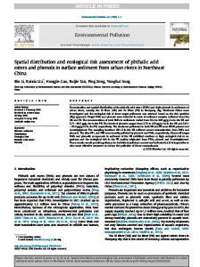
Conceptual models were developed for human health and safety, plus five ecological models were developed for each scenario (all workgroups completed these separately). They are included in were developed for each scenario (all workgroups completed these separately). They are included in were developed for each scenario (all workgroups completed these separately). They are included in were developed for each scenario (all workgroups completed these separately). They are included in the project report [38]. The numbers in the matrix cells (1–8) indicate the path by which a hazard can the project report [38]. The numbers in the matrix cells (1–8) indicate the path by which a hazard can the project report [38]. The numbers in the matrix cells (1–8) indicate the path by which a hazard can the project report [38]. The numbers in the matrix cells (1–8) indicate the path by which a hazard can affect a resource. The completed model for each scenario presents the participants’ decision making affect a resource. The completed model for each scenario presents the participants’ decision making affect a resource. The completed model for each scenario presents the participants’ decision making affect a resource. The completed model for each scenario presents the participants’ decision making and reasoning for each scenario workgroup about the concern for each resource. NA represents the and reasoning for each scenario workgroup about the concern for each resource. NA represents the and reasoning for each scenario workgroup about the concern for each resource. NA represents the and reasoning for each scenario workgroup about the concern for each resource. NA represents the J. Mar. Sci. Eng. 2016, 4, 23 17 of 26 absence of a connection between a potential hazard and the resource of concern as determined by the absence of a connection between a potential hazard and the resource of concern as determined by the absence of a connection between a potential hazard and the resource of concern as determined by the absence of a connection between a potential hazard and the resource of concern as determined by the workgroup participants for the individual scenario. workgroup participants for the individual scenario. workgroup participants for the individual scenario. workgroup participants for the individual scenario. Recognizing the distinctive oil behaviors of Bakken crude and dilbit oils, the conceptual models Recognizing the distinctive oil behaviors of Bakken crude and dilbit oils, the conceptual models Recognizing the distinctive oil behaviors of Bakken crude and dilbit oils, the conceptual models Recognizing the distinctive oil behaviors of Bakken crude and dilbit oils, the conceptual models Recognizing the distinctive oil behaviors of Bakken crude and dilbit oils, the conceptual models developed for these oils reflect the two phases of potential exposure pathways: developed for these oils reflect the two phases of potential exposure pathways: developed for these oils reflect the two phases of potential exposure pathways: developed for these oils reflect the two phases of potential exposure pathways: developed for these oils reflect the two phases of potential exposure pathways: B1: Bakken on the water/soil surface (initially, as it begins to weather) B1: Bakken on the water/soil surface (initially, as it begins to weather) B1: Bakken on the water/soil surface (initially, as it begins to weather) ‚B2: Bakken within water column due to natural dispersion (later) B1: Bakken on the water/soil surface (initially, as it begins to weather) B1: Bakken on the water/soil surface (initially, as it begins to weather) B2: Bakken within water column due to natural dispersion (later) B2: Bakken within water column due to natural dispersion (later) B2: Bakken within water column due to natural dispersion (later) ‚ B2: Bakken within water column due to natural dispersion (later) D1: Dilbit before weathering (initially, from loss of lighter fractions through evaporation) D1: Dilbit before weathering (initially, from loss of lighter fractions through evaporation) D1: Dilbit before weathering (initially, from loss of lighter fractions through evaporation) D1: Dilbit before weathering (initially, from loss of lighter fractions through evaporation) ‚D2: Dilbit after weathering (later) D1: Dilbit before weathering (initially, from loss of lighter fractions through evaporation) D2: Dilbit after weathering (later) D2: Dilbit after weathering (later) ‚ D2: Dilbit after weathering (later) D2: Dilbit after weathering (later) 4.4. Risk Ranking Matrix 4.4. Risk Ranking Matrix 4.4. Risk Ranking Matrix 4.4. Risk Ranking Matrix 4.4. Risk Ranking Matrix The CERA uses a risk ranking matrix to assign levels of concern about the potential severity and The CERA uses a risk ranking matrix to assign levels of concern about the potential severity and The CERA uses a risk ranking matrix to assign levels of concern about the potential severity and The CERA uses a risk ranking matrix to assign levels of concern about the potential severity and The CERA uses a risk ranking matrix to assign levels of concern about the potential severity duration of impacts caused by the spilled oil, if left to attenuate naturally, or as addressed by the duration of impacts caused by the spilled oil, if left to attenuate naturally, or as addressed by the duration of impacts caused by the spilled oil, if left to attenuate naturally, or as addressed by the duration of impacts caused by the spilled oil, if left to attenuate naturally, or as addressed by the and duration of impacts caused by the4.2. spilled oil, if left to the attenuate naturally, or as addressed individual response actions listed in Section 4.2. After reviewing the risk matrix from previous individual individual response response actions actions listed listed in in Section Section 4.2. After After reviewing reviewing the risk risk matrix matrix from from previous previous individual response actions listed in Section 4.2. After reviewing the risk matrix from previous by the individual response actions listed in Section 4.2. After reviewing the risk matrix from CERAs, a modification was adopted for evaluating the relative levels of concern of the impacts of CERAs, a modification was adopted for evaluating the relative levels of concern of the impacts of CERAs, a modification was adopted for evaluating the relative levels of concern of the impacts of CERAs, a modification was adopted for evaluating the relative levels of concern of the impacts of previous CERAs, a modification was adopted for evaluating the relative levels of concern Bakken or dilbit oils in the five scenarios. The Y‐axis of the risk ranking matrix shown in Figure 6, of Bakken or dilbit oils in the five scenarios. The Y‐axis of the risk ranking matrix shown in Figure 6, Bakken or dilbit oils in the five scenarios. The Y‐axis of the risk ranking matrix shown in Figure 6, Bakken or dilbit oils in the five scenarios. The Y‐axis of the risk ranking matrix shown in Figure 6, the impacts of Bakken or dilbit oils in the five scenarios.severity, The Y-axis of than the risk ranking matrix was used to describe describe the collectively perceived ecological severity, rather than the percent was was used used to to describe the the collectively collectively perceived perceived ecological ecological severity, rather rather than the the percent percent was used to describe the collectively perceived ecological severity, rather than the percent shown in Figure 6, was used to describe the collectively perceived ecological severity, rather loss/reduction of of the the specific specific natural natural resource resource based based on on a a a measured measured endpoint endpoint that that is not loss/reduction loss/reduction of the specific natural resource based on measured endpoint that is is not not than loss/reduction of the specific natural resource based on a measured endpoint that is the percent loss/reduction of the specific natural resource based on a measured endpoint that is site‐specific/species‐specific/community‐specific to the instant scenarios and were not always site‐specific/species‐specific/community‐specific site‐specific/species‐specific/community‐specific to to the the instant instant scenarios scenarios and and were were not not always always not site‐specific/species‐specific/community‐specific to the instant scenarios and always not site-specific/species-specific/community-specific to the instant scenarios andwere werenot not always applicable to the selected scenarios. The X‐axis in Figure 6 describes Recovery Time over arbitrary, applicable to the selected scenarios. The X‐axis in Figure 6 describes Recovery Time over arbitrary, applicable to the selected scenarios. The X‐axis in Figure 6 describes Recovery Time over arbitrary, applicable to the selected scenarios. The X‐axis in Figure 6 describes Recovery Time over arbitrary, applicable to the selected scenarios. The X-axis in Figure 6 describes Recovery Time over arbitrary, but participant‐consensus based, periods of time. Use of the matrix is qualitatively dependent on the but participant‐consensus based, periods of time. Use of the matrix is qualitatively dependent on the but participant‐consensus based, periods of time. Use of the matrix is qualitatively dependent on the but participant‐consensus based, periods of time. Use of the matrix is qualitatively dependent on the but participant-consensus based, periods of time. Use of the matrix is qualitatively dependent on individual participant’s experience and perception with respect to the complexity of the habitats and individual participant’s experience and perception with respect to the complexity of the habitats and individual participant’s experience and perception with respect to the complexity of the habitats and individual participant’s experience and perception with respect to the complexity of the habitats and the individual participant’s experience and perception with respectthrough to the complexity ofof the habitats species present. Notwithstanding, the final ranking of risk achieved through consensus of the species species present. present. Notwithstanding, Notwithstanding, the the final final ranking ranking of of risk risk is is is achieved achieved through consensus consensus of the the species present. Notwithstanding, the final ranking of risk is achieved through consensus of the and species present. Notwithstanding, the final ranking of risk is achieved through consensus of the participants thereby arriving at an estimation of the risk that is acceptable to multiple parties. participants thereby arriving at an estimation of the risk that is acceptable to multiple parties. participants thereby arriving at an estimation of the risk that is acceptable to multiple parties. participants thereby arriving at an estimation of the risk that is acceptable to multiple parties. participants thereby arriving at an estimation of the risk that is acceptable to multiple parties.
Figure 6. Levels of concerns risk matrix used in the Bakken and dilbit oil CERA. Figure Levels of concerns risk matrix used in the Bakken and dilbit oil CERA. Limited Limited Level Figure Figure 6. 6. 6. Levels Levels of of concerns concerns risk risk matrix matrix used used in in the the Bakken Bakken and and dilbit dilbit oil oil CERA. CERA. Limited Limited Figure 6. Levels of concerns risk matrix used in the Bakken and dilbit oil CERA. Limited Level of Concern; Moderate Level of Concern; High Level of Concern. of Concern; Moderate Level of Concern; Level of Concern. Level of Concern; Level of Concern; Moderate Level of Concern; Moderate Level of Concern; High High Level of Concern. High Level of Concern. Level of Concern; Moderate Level of Concern; High Level of Concern.
Participants evaluated potential risks of the oil and response actions and assigned levels of concern using the best available information from literature, past experience with oil spills in an area, e.g., the 2004 oil spill from the M/V Athos-1 in the Delaware River, and their knowledge of resources in the area, rather than additional data collection or field studies. As can be seen in the risk matrix, the groups used alphanumeric scores to scale the anticipated impact severity and recovery time. After developing the scaling, color coding was used to indicate the summary levels of concern. The resulting risk scores represent a participant consensus that severity and duration of consequences were likely to occur in the given scenario.
J. Mar. Sci. Eng. 2016, 4, 23
18 of 26
Risk is defined as the probability of an impact occurring. Participants qualitatively considered if there was a high, medium, or low probability of the impact occurring, and then determined the severity and the duration of the impact. During an incident, responders tend to consider and decide about impacts that are relatively short-term and based upon what was learned from previous response events, e.g., it is better to protect marshes to avoid having them oiled because of the longer-term severity and duration of oil impacts in those environments. The response community recognizes that protecting marshes from oiling is a best response management practice; this knowledge proactively and affirmatively guides many preparedness and response decisions. For any T/E species, any harm qualifies as a take under the Endangered Species Act, Section 7, and Incidental Take of Endangered and Threatened Species in U.S. Lands or Waters. Being listed on the ESA makes it illegal to take. Take is defined as harass, harm, pursue, hunt, shoot, wound, kill, trap, capture, collect, or attempt to do these things (50 CFR § 3(19), 2009) any of these protected species, whether endangered or threatened or adversely modify or destroy designated critical habitat under Section 9—Prohibited Acts. These prohibitions under Section 9 are not automatic for threatened species; the USFWS and NMFS must conduct a Section 4 process to address threatened species. and is significant. As generally applied in this ERA, non T/E plants would recover in four to five years and non T/E fish would recover in one to two years. The ranking of red does not mean to stop response actions, but rather to review and assure that response actions would not adversely affect the species of concern, that the risk is recognized, and deemed appropriate to decision makers, including resource managers. The definitions of ecological severity used by participants in assessing risk in this CERA are: ‚ ‚ ‚ ‚
Discountable: Impacts are considered negligible, trivial, or a minor inconvenience. Impaired: Short-lived modestly adverse impacts that alter habitats or life cycles. Significant: Sustained and substantive adverse impacts that potentially lethal or highly damaging to a natural resource(s). Dysfunctional: Long term damage that prohibits a natural resource from living, reproducing, or providing an ecological service(s).
The ranking measures were also appropriate for characterizing human health risks. The impact from a drinking water ban would likely be considered Dysfunctional in severity; inhalation and dermal impacts might be ranked as Significant. Duration of impact begins from the time of the oil discharge. Severity takes into account the significance of individual organisms relative to the scale of population. For example, if an organism has recovered 70% in about one year, but would take 10 years for 100% recovery, then the risk could be ranked as significant, in the one to four-year duration. Local populations that could be killed by a spill would receive a dysfunctional score. Freshwater mussels, for example, if wiped out by oiling in a creek, will not recover for 50–100 years. This would equate to a risk of a dysfunctional impact. Generally, participants considered populations of organisms at the local scale, and assumed no impacts on a regional or national scale for that species. 4.5. Risk Characterization The conceptual models were used first to clarify the pathways of exposure and the types of hazards between the spilled oil and seasonally-present ecological resources. The risk matrix was first completed by each workgroup to characterize the risks to resources of concern from the oil only, i.e., no response action, except for natural attenuation and monitoring (NAM). Next, participants compared the potential risks of each category of response actions to the risks associated with the spilled oil left in place to attenuate, plus monitoring via sampling. Relative risks were compared in this way: ‚ ‚
If using a response action is likely to improve the outcome, the score is a lower alphanumerical value than the spilled oil (NAM). If using a response action is likely to worsen the outcome, the score is a higher alphanumerical value than the spilled oil (NAM).
spilled oil left in place to attenuate, plus monitoring via sampling. Relative risks were compared in spilled oil left in place to attenuate, plus monitoring via sampling. Relative risks were compared in spilled oil left in place to attenuate, plus monitoring via sampling. Relative risks were compared in this way: this way: this way: If using a response action is l value than the spilled oil (NA If using a response action is likely to improve the outcome, the score is a lower alphanumerical If using a response action is likely to improve the outcome, the score is a lower alphanumerical If using a response action is likely to improve the outcome, the score is a lower alphanumerical If using a response action is l value than the spilled oil (NAM). value than the spilled oil (NAM). value than the spilled oil (NAM). value than the spilled oil (NA J. Mar.If using a response action is likely to worsen the outcome, the score is a higher alphanumerical Sci. Eng. 2016, 4, 23 19 of 26 If using a response action is likely to worsen the outcome, the score is a higher alphanumerical If using a response action is likely to worsen the outcome, the score is a higher alphanumerical value than the spilled oil (NAM). value than the spilled oil (NAM). value than the spilled oil (NAM). Selecting appropriate respons in the environment before and a Selecting appropriate response strategies for each of these oils takes into account their behavior Selecting appropriate response strategies for each of these oils takes into account their behavior Selecting appropriate response strategies for each of these oils takes into account their behavior Selecting appropriate response strategies for each of these oils takes into account their behavior in summarized risks for the oils and s in the environment before and after weathering. For this Figures reason, Figures 7 display and display the in the the environment environment before and after weathering. For this this reason, Figures and display the in before and after weathering. For this reason, Figures 7 7 and 9 9 the the environment before and after weathering. For reason, 7 and 8 display the9 summarized and Figures 8 and 10 display the s summarized risks for the oils and strategies for the initial spill of oil before it has a chance to weather summarized risks for the oils and strategies for the initial spill of oil before it has a chance to weather summarized risks for the oils and strategies for the initial spill of oil before it has a chance to weather risks for the oils and strategies for the initial spill of oil before it has a chance to weather and Figures 9 weathered. For convenience, a row and Figures 8 and 10 display the summarized risks for the oils and strategies for the oil after it has and Figures 8 and 10 display the summarized risks for the oils and strategies for the oil after it has and Figures 8 and 10 display the summarized risks for the oils and strategies for the oil after it has and 10 display the summarized risks for the oils and strategies for the oil after it has weathered. For or bay) of each of the scenarios has weathered. For convenience, a row that highlights the transportation setting (i.e., urban, creek, river weathered. For convenience, a row that highlights the transportation setting (i.e., urban, creek, river weathered. For convenience, a row that highlights the transportation setting (i.e., urban, creek, river convenience, a row that highlights the transportation setting (i.e., urban, creek, river or bay) of each of or bay) of each of the scenarios has been added to the summary tables. J. Mar. Sci. Eng. 2016, 4, 23 20 of 26 or bay) of each of the scenarios has been added to the summary tables. or bay) of each of the scenarios has been added to the summary tables. the scenarios has been added to the summary tables. Artificial Shorelines
Habitat Shoreline (Exposed & IntertidalShoreline ShorelineIntertidal (Exposed Sub habitats Intertidal Shoreline (Exposed (Exposed &&& Artificial Shorelines Natural TerrestrialIntertidal Shorelines Mid-water (0 to 2 Benthic meters) Benthic (bottom, >2 meters) Intertidal Shoreline (Exposed & (0(0to ArtificialShorelines Shorelines NaturalTerrestrial TerrestrialShorelines Shorelines Mid-water meters) Benthic(bottom, (bottom,>2 meters) Artificial Artificial Shorelines Natural Natural Terrestrial Shorelines Mid-water Mid-water toto222meters) meters) >2>2 meters) meters) Sheltered) (0 - 1 (0 Artificial Shorelines Natural TerrestrialSheltered) Shorelines Mid-water (0 to 2 Benthic meters) (bottom, Benthic (bottom, >2 meters) Sheltered) /Surface Surface Water(0 1Surface Water Sheltered) // Surface Water Water (0(0-- /1-1/ Surface Sheltered) Water (0 - 1 SCENARIO Bulkheads, Riprap, Manmade Vegetated,Grass, Sand, Gravel Marsh, Swamp, Tidal flats, Sand Water Column Bottom of the Water Column / Bulkheads,Riprap, Riprap,Manmade Manmade Riprap, Vegetated,Grass, Sand, Gravel Marsh,Swamp, Swamp,Tidal Tidal flats,Sand Sand Tidal flats, Sand WaterColumn Column Water Column Bottomof theWater Water Column / Water Column Bulkheads, Bulkheads, Riprap, Manmade Vegetated,Grass, Vegetated,Grass, Sand, Sand, Gravel Gravel Marsh, Marsh, Swamp, Tidal flats, flats, Sand Water Water Column Bottom Bottom ofofthe the Water Column Column Sub habitats Bulkheads, Manmade Vegetated,Grass, Sand, Gravel Marsh, Swamp, Bottom of//the / Subhabitats habitats Sub Sub habitats Transportation Setting Sub habitats Seabed Structures, Pavement Beaches, Cobble/Boulder Beach Seabed Structures,Pavement Pavement Beaches,Cobble/Boulder Cobble/Boulder Beach Seabed Seabed Structures, Structures, Pavement Beaches, Beaches, Cobble/Boulder Beach Beach Structures, Pavement Beaches, Cobble/Boulder Beach Seabed Response Actions SCENARIO 1 2 3 1 2 3 1 2 3 1 2 3 1 2 3 SCENARIO 1 2 3 1 2 3 1 2 3 1 2 3 1 2 3 SCENARIO SCENARIO 11 22 33 11 22 33 SCENARIO 1 33 2 11 3 22 1 33 2 11 3 22 1 33 2 11 3 22 1 2 3 1 2 3 Transportation SettingUrban Bay River Urban Bay River Bay TransportationSetting Setting Urban RiverUrban Bay River Urban Bay RiverUrban Bay River Urban Bay RiverUrban Bay River Urban Bay RiverUrban Bay River Urban Bay River Bay River Transportation Transportation Setting Urban River River Bay Urban River Bay Urban River Bay Urban River Bay Urban River Transportation Setting UrbanBay RiverUrban BayRiver UrbanBay RiverUrban Bay River Urban Bay RiverUrban Bay River Urban Bay River Urban Urban Bay Bay Oil Only: No response action except Response Actions Response Actions Response Actions monitoring (air: flammability, benzene, Response Actions etc.; soil; water; and stranded onshore J. Mar. Sci. Eng. 2016, 4, 23 Oil Only: No response action except Oil Only: No response action except Oil Only: No response action except Oil Only: No response action except Oil Only: No response action except oil) monitoring (air: flammability, benzene, monitoring (air: flammability, benzene, monitoring (air: flammability, benzene, monitoring (air: flammability, benzene, monitoring (air: flammability, benzene, etc.; soil; water; and stranded onshore etc.; soil; water; and stranded onshore etc.; soil; water; and stranded onshore etc.; soil; water; and stranded onshore J. Mar. Sci. Eng. 2016, 4, 23 19 of 26 etc.; soil; water; and stranded onshore Fire 19 of 26 J. Mar. Sci. Eng. 2016, 4, 23 oil) oil) oil) oil) oil) Let burn and controlled burn (both in‐ situ) Fire Fire Fire Fire Fire Let burn and controlled burn (both in‐ Let burn and controlled burn (both in‐ Let burn and controlled burn (both in‐ Let burn and controlled burn (both in‐ Let burn and controlled burn (both in‐ Extinguishing agents and methods situ) situ) situ) situ) situ) Habitat Habitat Habitat
Habitat Habitat
Bulkheads, Riprap, Manma Structures, Pavement 1 2 Urban River B
compared the potential risks of ea spilled oil left in place to attenuate compared the the potential potential risks risks of of each each category category of of response response actions actions to to the the risks risks associated associated with with the the compared this way: spilled oil left in place to attenuate, plus monitoring via sampling. Relative risks were compared in spilled oil left in place to attenuate, plus monitoring via sampling. Relative risks were compared in No Fire Extinguishing agents and methods Extinguishing agents and methods Extinguishing agents and methods Extinguishing agents and methods Extinguishing agents and methods this way: this way: Vapor suppression If using a response action is l No Fire No Fire No Fire No Fire No Fire value than the spilled oil (NA Oil spread control Vapor suppression If using a response action is likely to improve the outcome, the score is a lower alphanumerical Vapor suppression If using a response action is likely to improve the outcome, the score is a lower alphanumerical Vapor suppression Vapor suppression Vapor suppression On‐water oil recovery If using a response action is l Oil spread control Oil spread control value than the spilled oil (NAM). Oil spread control value than the spilled oil (NAM). Oil spread control Oil spread control Resource protection On‐water oil recovery value than the spilled oil (NA On‐water oil recovery On‐water oil recovery On‐water oil recovery If using a response action is likely to worsen the outcome, the score is a higher alphanumerical On‐water oil recovery If using a response action is likely to worsen the outcome, the score is a higher alphanumerical Shoreline clean up Resource protection Resource protection Resource protection Resource protection Resource protection Oil Detection/mapping ‐ remotely value than the spilled oil (NAM). value than the spilled oil (NAM). Selecting appropriate respons Shoreline clean up Shoreline clean up observed methods Shoreline clean up Shoreline clean up Shoreline clean up Oil Detection/mapping ‐ remotely in the environment before and a Oil Detection/mapping ‐ remotely Oil Detection/mapping ‐ remotely Oil Detection/mapping ‐ remotely Oil Detection/mapping ‐ remotely observed methods Selecting appropriate response strategies for each of these oils takes into account their behavior Selecting appropriate response strategies for each of these oils takes into account their behavior observed methods observed methods observed methods observed methods summarized risks for the oils and s in the the environment environment before before and and after after weathering. weathering. For For this this reason, reason, Figures Figures 7 7 and and 9 9 display display Figure the 7. Summary Risk Chara in the and Figures 8 and 10 display the s summarized risks for the oils and strategies for the initial spill of oil before it has a chance to weather summarized risks for the oils and strategies for the initial spill of oil before it has a chance to weather Figure Summary Risk Characterization for Bakken the oil Bakken oil scenarios (initial release). Figure 8. Summary Risk Characterization for the Bakken oil scenarios (weathered). Limited Level of Concern; Figure 7.7. Summary Risk Characterization forBakken the scenarios (initialrelease). release). Limited Figure 7. 7. Summary Risk Characterization Characterization for the the Bakken oil oil scenarios (initial release). Figure Summary Risk for scenarios (initial Limited weathered. For convenience, a row and Figures 8 and 10 display the summarized risks for the oils and strategies for the oil after it has and Figures 8 and 10 display the summarized risks for the oils and strategies for the oil after it has or bay) of each of the scenarios has Limited of Concern; Moderate Moderate of Concern; High High Level of Concern; Not Applicable. Level of Concern; Moderate Level of Concern; Concern; Level Concern; of Limited Level Level of of Level Concern; Moderate Moderate Level of of Level Concern; High Level of Concern; High Level Level of Concern; Concern; Limited Level of Concern; Level of Concern; High Level of Concern; weathered. For convenience, a row that highlights the transportation setting (i.e., urban, creek, river weathered. For convenience, a row that highlights the transportation setting (i.e., urban, creek, river Not Applicable. Not Applicable. or bay) of each of the scenarios has been added to the summary tables. or bay) of each of the scenarios has been added to the summary tables. Not Applicable. Not Applicable. Not Applicable. Artificial Shorelines Habitat Bakken and dilbit oils present Bulkheads, Riprap, Manma Intertidal Shoreline (Exposed IntertidalShoreline Shoreline(Exposed (Exposed&&& habitats 2013 derailment in Lac‐Megantic, Intertidal Intertidal Shoreline (Exposed Artificial Shorelines (0 to 2 (bottom, meters) BenthicSub (bottom, >2 meters) Habitat Artificial ArtificialShorelines Shorelines Natural Terrestrial Shorelines Natural Terrestrial Shorelines & Sheltered) Mid-water meters) Mid-waterBenthic Benthic (bottom,>2 >2meters) meters) Habitat Bakken and dilbit oils present flammability hazards during the early stages of a spill, such as the Structures, Pavement Artificial Shorelines Natural Natural Terrestrial Terrestrial Shorelines Shorelines Mid-water Mid-water (0 (0(0to totoWater 222meters) meters) Benthic (bottom, >2 meters) Habitat Habitat Bakken and dilbit oils present flammability hazards during the early stages of a spill, such as the Bakken and dilbit oils present flammability hazards during the early stages of a spill, such as the / Surface Sheltered)// /Surface SurfaceWater Water(0 Sheltered) Sheltered) Surface Water (0(0---111 SCENARIO 1 2 loss of life. The risks to human he Bulkheads, Riprap, Manmade Vegetated, Grass, Sand, Marsh, Swamp, Tidal Flats, Water Column Bottom of the Water Column / Bulkheads, Riprap, Manmade Vegetated,Grass, Sand, Gravel Marsh, Swamp, Tidal flats, Sand Water Column Bottom of the Water Column / Bulkheads, Bulkheads, Riprap, Riprap, Manmade Manmade Vegetated,Grass, Vegetated,Grass, Sand, Sand, Gravel Gravel Marsh, Marsh, Swamp, Swamp, Tidal Tidal flats, flats, Sand Sand Water Water Column Column Bottom Bottom of of the the Water Water Column Column / / 2013 derailment in Lac‐Megantic, Canada that resulted in Bakken oil fire in the center of town and Sub habitats Subhabitats habitats 2013 derailment in Lac‐Megantic, Canada that resulted in Bakken oil fire in the center of town and Sub Sub habitats 2013 derailment in Lac‐Megantic, Canada that resulted in Bakken oil fire in the center of town and Transportation Setting Urban River B Seabed Structures,Pavement Pavement Beaches, Cobble/BoulderBeach Beach Structures, Pavement Gravel Sand Beaches, Seabed Seabed Seabed Structures, Structures, Pavement Beaches, Beaches, Cobble/Boulder Cobble/Boulder Beach as firefighting foam, as highlighted Response Actions SCENARIO 1 2 3 1 2 3 1 2 3 1 2 3 1 2 3 SCENARIO SCENARIO 1 1 2 2 3 3 1 1 2 2 3 3 1 1 2 2 3 3 1 1 2 2 3 3 1 1 2 2 3 3 loss of life. The risks to human health and safety and social‐economic resources from a fire, as well SCENARIO 4 5 4 5 4 5 4 5 4 5 loss of life. The risks to human health and safety and social‐economic resources from a fire, as well loss of life. The risks to human health and safety and social‐economic resources from a fire, as well TransportationSetting Setting Transportation Urban River Bay Urban River River Bay Bay Urban River Bay Creek Urban River BayCreek Urban Urban River River Bay Transportation Transportation Setting Urban Urban River Bay Bay Urban Urban River Bay Urban Urban River River Bay Urban Urban River River Bay Bay Urban River River Bay Bay Setting River Creek River Creek River Bay River Creek River assuming that safety measures we Oil Only: No response action except as firefighting foam, as highlighted in Scenario 1, were scored as a moderate level of concern (yellow) as firefighting foam, as highlighted in Scenario 1, were scored as a moderate level of concern (yellow) as firefighting foam, as highlighted in Scenario 1, were scored as a moderate level of concern (yellow) Response Actions Response Actions monitoring (air: flammability, benzene, Response Actions for the public, such as safe distanc etc.; soil; water; and stranded onshore assuming that safety measures were successful, e.g., PPE for workers and other protective measures assuming that safety measures were successful, e.g., PPE for workers and other protective measures Oil Only: No response action except assuming that safety measures were successful, e.g., PPE for workers and other protective measures Oil Only: No response action except Oil Only: No response action except oil) Oil Only: No response action except monitoring monitoring (air: flammability, benzene, monitoring (air: flammability, benzene, monitoring (air: flammability, benzene, human health and safety, the level (air: flammability, benzene, etc.; soil; water; and for the public, such as safe distance from fire and shelter in place away from the smoke plume. For for the public, such as safe distance from fire and shelter in place away from the smoke plume. For for the public, such as safe distance from fire and shelter in place away from the smoke plume. For etc.; soil; water; and stranded onshore etc.; soil; water; and stranded onshore etc.; soil; water; and stranded onshore Fire stranded onshore oil) oil) scored as low (green). oil) oil) human health and safety, the levels of concern from the oil only and for other response actions were Let burn and controlled burn (both in‐ human health and safety, the levels of concern from the oil only and for other response actions were human health and safety, the levels of concern from the oil only and for other response actions were Fire situ) The red ranking (high level of Fire Fire Fire scored as low (green). scored as low (green). scored as low (green). Let burn and controlled burn (both in‐ Let burn and controlled burn (both in‐situ) Let burn and controlled burn (both in‐ Let burn and controlled burn (both in‐ Extinguishing agents and methods other agencies in the area to more f situ) The red ranking (high level of concern) represents a need for follow‐up action by the USCG and situ) situ) The red ranking (high level of concern) represents a need for follow‐up action by the USCG and The red ranking (high level of concern) represents a need for follow‐up action by the USCG and Extinguishing agents and methods No Fire if so, under what circumstances, e.g Extinguishing agents and methods Extinguishing agents and methods Extinguishing agents and methods other agencies in the area to more fully address whether certain response actions will be allowed and other agencies in the area to more fully address whether certain response actions will be allowed and other agencies in the area to more fully address whether certain response actions will be allowed and No Fire Vapor suppression highest relative risk, is not intende No Fire if so, under what circumstances, e.g., in certain seasons or under specific conditions. The red ranking, No Fire No Fire if so, under what circumstances, e.g., in certain seasons or under specific conditions. The red ranking, if so, under what circumstances, e.g., in certain seasons or under specific conditions. The red ranking, Vapor suppression Oil spread control review and assure that response a Vapor suppression Vapor suppression Vapor suppression highest relative risk, is not intended to prevent or stop response actions, but rather to prompt further On‐water oil recovery Oil spread control highest relative risk, is not intended to prevent or stop response actions, but rather to prompt further highest relative risk, is not intended to prevent or stop response actions, but rather to prompt further Oil spread control Oil spread control Oil spread control CERA, participants generally assig Resource protection On‐water oil recovery review and assure that response actions would not adversely affect the resources of concern. In this review and assure that response actions would not adversely affect the resources of concern. In this review and assure that response actions would not adversely affect the resources of concern. In this On‐water oil recovery On‐water oil recovery On‐water oil recovery Shoreline clean up with a spill of dilbit oil compared t Resource protection CERA, participants generally assigned higher levels of concern about the ecological risks associated CERA, participants generally assigned higher levels of concern about the ecological risks associated CERA, participants generally assigned higher levels of concern about the ecological risks associated Resource protection Resource protection Resource protection Oil Detection/mapping ‐ remotely Shoreline clean up observed methods with a spill of dilbit oil compared to a spill of Bakken crude oil. Shoreline clean up Shoreline clean up Shoreline clean up with a spill of dilbit oil compared to a spill of Bakken crude oil. with a spill of dilbit oil compared to a spill of Bakken crude oil. Oil Detection/mapping ‐ physical Oil Detection/mapping ‐ remotely Oil Detection/mapping ‐ remotely Oil Detection/mapping ‐ remotely detection/remotely observed methods observed methods observed methods observed methods
Figure 7. Summary Risk Chara Figure 9. Summary Risk Characterization for the dilbit oil scenarios (initial release). Figure 8. Summary Risk Characterization forBakken the dilbit scenarios(initial (initialrelease). release). Figure 7. 7. Summary Risk Characterization Characterization for the the Bakken oil oil scenarios (initial release). Figure Summary Risk for oil scenarios Level of Concern; Limited Level Level of of Concern; Concern; Limited Level of Concern; Not Applicable. Not Applicable. Not Applicable. Not Applicable.
Moderate Level of Concern; Moderate Level Level of of Concern; Concern; Moderate Moderate Level of Concern;
Limited Level of Concern; Limited Limited
High High Level of Concern; High Level Level of of Concern; Concern; High Level of Concern;
Not Applicable.
Bakken and dilbit oils present The gray cells scored “Not Applicable” refer to the absence of either the resource of concern in 2013 derailment in Lac‐Megantic, Bakken and dilbit oils present flammability hazards during the early stages of a spill, such as the Bakken and dilbit oils present flammability hazards during the early stages of a spill, such as the a scenario or the lack of pathway for exposure to the hazard presented by the oil or type of response loss of life. The risks to human he 2013 derailment in Lac‐Megantic, Canada that resulted in Bakken oil fire in the center of town and 2013 derailment in Lac‐Megantic, Canada that resulted in Bakken oil fire in the center of town and action. For example, in Scenario 3, which involves a spill of Bakken oil in the upper Delaware Bay in as firefighting foam, as highlighted loss of life. The risks to human health and safety and social‐economic resources from a fire, as well loss of life. The risks to human health and safety and social‐economic resources from a fire, as well winter, during the first 4–6 h, the risk to shorelines and benthos were scored as assuming that safety measures we Not Applicable as firefighting foam, as highlighted in Scenario 1, were scored as a moderate level of concern (yellow) as firefighting foam, as highlighted in Scenario 1, were scored as a moderate level of concern (yellow) because the oil would not reach those environments in that time frame. for the public, such as safe distanc
summarized risks for the oils and s in the the environment environment before before and and after after weathering. weathering. For For this this reason, reason, Figures Figures 7 7 and and 9 9 display display the the in and Figures 8 and 10 display the s summarized risks for the oils and strategies for the initial spill of oil before it has a chance to weather summarized risks for the oils and strategies for the initial spill of oil before it has a chance to weather weathered. For convenience, a row and Figures 8 and 10 display the summarized risks for the oils and strategies for the oil after it has and Figures 8 and 10 display the summarized risks for the oils and strategies for the oil after it has or bay) of each of the scenarios has weathered. For convenience, a row that highlights the transportation setting (i.e., urban, creek, river weathered. For convenience, a row that highlights the transportation setting (i.e., urban, creek, river J. Mar. Sci. Eng. 2016, 4, 23 20 of 26 or bay) of each of the scenarios has been added to the summary tables. or bay) of each of the scenarios has been added to the summary tables. J. Mar. Sci. Eng. 2016, 4, 23 20 of 26 Artificial Shorelines
Habitat IntertidalShoreline Shoreline(Exposed (Exposed&&& Sub habitats Intertidal Intertidal Shoreline (Exposed ArtificialShorelines Shorelines NaturalTerrestrial TerrestrialShorelines Shorelines Mid-water meters) Benthic(bottom, (bottom,>2 >2meters) meters) Artificial Artificial Shorelines Natural Natural Terrestrial Shorelines Mid-water Mid-water (0(0to toto222meters) meters) Benthic Benthic (bottom, >2 meters) Intertidal (Exposed & (0 Sheltered) Surface Water(0 Sheltered) Surface Water Water (0(0Shoreline ---111 Artificial Shorelines Natural TerrestrialSheltered) Shorelines///Surface Mid-water (0 to 2 meters) Benthic (bottom, >2 meters) SCENARIO Sheltered) / Surface Water (0 1 Bulkheads, Riprap, Manmade Vegetated,Grass, Sand, Gravel Marsh, Swamp, Tidal flats, Sand Water Column Bottom of the Water Column / Bulkheads, Bulkheads, Riprap, Riprap, Manmade Manmade Vegetated,Grass, Vegetated,Grass, Sand, Sand, Gravel Gravel Marsh, Marsh, Swamp, Swamp, Tidal Tidal flats, flats, Sand Sand Water Water Column Column Bottom Bottom of of the the Water Water Column Column // Subhabitats habitats Sub Sub habitats Setting Bulkheads, Riprap, Manmade Vegetated,Grass, Sand, Gravel Marsh, Beach Swamp, Tidal flats, Sand Water Column Bottom ofTransportation the Water Column / Seabed Structures, Pavement Beaches, Cobble/Boulder Beach Seabed Seabed Structures, Structures, Pavement Pavement Beaches, Beaches, Cobble/Boulder Cobble/Boulder Beach Sub habitats Structures, Pavement Response Actions SCENARIO 3 SCENARIO SCENARIO 111 222 333 111 222 333 111 222 Beaches, 33Cobble/Boulder 111 Beach 222 333 111 222 333 Seabed 1 3 TransportationSetting Setting SCENARIO Urban Urban River 1 Bay Bay 2 Urban Urban 3 River River 1 Bay Bay 2 Urban Urban 3 River River 1 Bay Bay 2 Urban Urban 3 River River 1 Bay Bay 2 Urban Urban 3 River River Bay 2 Transportation Transportation Setting Urban River River Bay Urban River Bay Urban River Bay Urban River Bay Urban River Bay Bay Oil Only: No response action except Transportation Setting Urban River Bay Urban River Bay Urban River Bay Urban River Bay Urban River Bay Response Actions Response Actions monitoring (air: flammability, benzene, Response Actions J. Mar. Sci. Eng. 2016, 4, 23 etc.; soil; water; and stranded onshore Oil Only: No response action except Oil Only: No response action except Oil Only: No response action except oil) Oil Only: No response action except monitoring (air: flammability, benzene, monitoring (air: flammability, benzene, monitoring (air: flammability, benzene, J. Mar. Sci. Eng. 2016, 4, 23 19 of 26 monitoring (air: flammability, benzene, J. Mar. Sci. Eng. 2016, 4, 23 J. Mar. Sci. Eng. 2016, 4, 23 19 of 26 19 of 26 etc.; soil; water; and stranded onshore etc.; soil; water; and stranded onshore etc.; soil; water; and stranded onshore Fire etc.; soil; water; and stranded onshore oil) oil) oil) Let burn and controlled burn (both in‐ oil) situ) Fire Fire Fire Fire Let burn and controlled burn (both in‐ Let burn and controlled burn (both in‐ Let burn and controlled burn (both in‐ Extinguishing agents and methods Let burn and controlled burn (both in‐ situ) situ) situ) situ) No Fire Extinguishing agents and methods Extinguishing agents and methods Extinguishing agents and methods Extinguishing agents and methods Vapor suppression No Fire No Fire No Fire No Fire Oil spread control Vapor suppression Vapor suppression Vapor suppression Vapor suppression On‐water oil recovery Oil spread control Oil spread control Oil spread control Oil spread control Resource protection On‐water oil recovery On‐water oil recovery On‐water oil recovery On‐water oil recovery Shoreline clean up Resource protection Resource protection Resource protection Resource protection Oil Detection/mapping ‐ remotely Shoreline clean up observed methods Shoreline clean up Shoreline clean up Shoreline clean up Habitat Habitat Habitat
Habitat
Bulkheads, Riprap, Manma Structures, Pavement 1 2 Urban River B
compared the potential risks of each spilled oil left in place to attenuate, pl compared the potential risks of each category of response response actions to the the risks associated with the compared compared the the potential potential risks risks of of each each category category of of response actions actions to to the risks risks associated associated with with the the this way: spilled oil left in place to attenuate, plus monitoring via sampling. Relative risks were compared in spilled oil left in place to attenuate, plus monitoring via sampling. Relative risks were compared in spilled oil left in place to attenuate, plus monitoring via sampling. Relative risks were compared in this way: this way: this way: If using a response action is likel value than the spilled oil (NAM). If using a response action is likely to improve the outcome, the score is a lower alphanumerical If using a response action is likely to improve the outcome, the score is a lower alphanumerical If using a response action is likely to improve the outcome, the score is a lower alphanumerical If using a response action is likel value than the spilled oil (NAM). value than the spilled oil (NAM). value than the spilled oil (NAM). value than the spilled oil (NAM). If using a response action is likely to worsen the outcome, the score is a higher alphanumerical If using a response action is likely to worsen the outcome, the score is a higher alphanumerical If using a response action is likely to worsen the outcome, the score is a higher alphanumerical value than the spilled oil (NAM). value than the spilled oil (NAM). value than the spilled oil (NAM). Selecting appropriate response str in the environment before and after Oil Detection/mapping ‐ remotely Selecting appropriate response strategies for each of these oils takes into account their behavior Selecting appropriate response strategies for each of these oils takes into account their behavior Selecting appropriate response strategies for each of these oils takes into account their behavior Oil Detection/mapping ‐ remotely Oil Detection/mapping ‐ remotely Oil Detection/mapping ‐ remotely observed methods observed methods summarized risks for the oils and strat observed methods observed methods in the environment before and after weathering. For this reason, Figures 7 and and 9 display display the in in the the environment environment before before and and after after weathering. weathering. For For this this reason, reason, Figures Figures 7 7 and 9 9 display the the Figure 7. Summary Risk Chara and Figures 8 and 10 display the sum summarized risks for the oils and strategies for the initial spill of oil before it has a chance to weather summarized risks for the oils and strategies for the initial spill of oil before it has a chance to weather summarized risks for the oils and strategies for the initial spill of oil before it has a chance to weather Figure 9. Summary Risk Characterization for the Bakken oil scenarios (weathered). Limited Level of Concern; Figure 7. 7. Summary Risk Characterization Characterization for the the Bakken oil scenarios scenarios (initial release). weathered. For convenience, a row tha Figure Summary Risk for Bakken oil (initial release). and Figures 8 and 10 display the summarized risks for the oils and strategies for the oil after it has Figure 8. Summary Risk Characterization for the Bakken oil scenarios (weathered). Limited and Figures 8 and 10 display the summarized risks for the oils and strategies for the oil after it has and Figures 8 and 10 display the summarized risks for the oils and strategies for the oil after it has or bay) of each of the scenarios has bee weathered. For convenience, a row that highlights the transportation setting (i.e., urban, creek, river weathered. For convenience, a row that highlights the transportation setting (i.e., urban, creek, river weathered. For convenience, a row that highlights the transportation setting (i.e., urban, creek, river Level Moderate Limited Level of Concern; Level of of Concern; Concern; Moderate Level Level of of Concern; Concern; High High Level Level of of Concern; Concern; Limited Level of Concern; Moderate Level of Concern; High Level of Concern; Moderate Level of Concern; High Level of Concern; Not Applicable. or bay) of each of the scenarios has been added to the summary tables. or bay) of each of the scenarios has been added to the summary tables. or bay) of each of the scenarios has been added to the summary tables. J. Mar. Sci. Eng. 2016, 4, 23 21 of 26 J. Mar. Sci. Eng. 2016, 4, 23 21 of 26 Not Applicable. Not Applicable. Not Applicable. Not Applicable.
Artificial Shorelines
Habitat
Bakken and dilbit oils present Bulkheads, Riprap, Manmade Structures, Pavement 2013 derailment in Lac‐Megantic, Bakken and dilbit oils present flammability hazards during the early stages of a spill, such as the Bakken and dilbit oils present flammability hazards during the early stages of a spill, such as the 1 2 3 loss of life. The risks to human he Urban River Bay 2013 derailment in Lac‐Megantic, Canada that resulted in Bakken oil fire in the center of town and 2013 derailment in Lac‐Megantic, Canada that resulted in Bakken oil fire in the center of town and as firefighting foam, as highlighted loss of life. The risks to human health and safety and social‐economic resources from a fire, as well loss of life. The risks to human health and safety and social‐economic resources from a fire, as well SCENARIOSCENARIO 4 5 4 5 4 5 4 5 4 5 4 5 4 5 4 5 4 5 assuming that safety measures we 4 5 Response Actions Transportation Setting Creek River Creek River Creek River Creek River Creek River Response Actions Response Actions monitoring (air: flammability, benzene, as firefighting foam, as highlighted in Scenario 1, were scored as a moderate level of concern (yellow) as firefighting foam, as highlighted in Scenario 1, were scored as a moderate level of concern (yellow) Transportation Setting Setting Creek Transportation Creek River River Creek Creek River River Creek CreekRiver River Creek Creek River River Creek Creek River River etc.; soil; water; and stranded onshore Response Actions for the public, such as safe distanc Oil Only: No response action except Oil Only: No response action except Oil Only: No response action except Response Actions Response Actions oil) assuming that safety measures were successful, e.g., PPE for workers and other protective measures assuming that safety measures were successful, e.g., PPE for workers and other protective measures monitoring (air: flammability, benzene, monitoring (air: flammability, benzene, monitoring (air: flammability, benzene, Oil Only: No response action except monitoring Oil Only: No response action except Oil Only: No response action except human health and safety, the level etc.; soil; water; and stranded onshore etc.; soil; water; and stranded onshore etc.; soil; water; and stranded onshore Fire for the public, such as safe distance from fire and shelter in place away from the smoke plume. For for the public, such as safe distance from fire and shelter in place away from the smoke plume. For (air: flammability, benzene, etc.; soil; water; and monitoring (air: flammability, benzene, etc.; monitoring (air: flammability, benzene, etc.; oil) oil)oil) scored as low (green). Let burn and controlled burn (both in‐ stranded onshore oil) soil; water; and stranded onshore oil) soil; water; and stranded onshore oil) human health and safety, the levels of concern from the oil only and for other response actions were human health and safety, the levels of concern from the oil only and for other response actions were situ) Fire FireFire Fire Fire The red ranking (high level of Fire scored as low (green). Let burn and controlled burn (both in‐ scored as low (green). Let burn and controlled burn (both in‐ Let burn and controlled burn (both in‐ Extinguishing agents and methods Let burn and controlled burn (both in‐situ) situ) Let burn and controlled burn (both in‐situ) situ) situ) Let burn and controlled burn (both in‐situ) other agencies in the area to more f The red ranking (high level of concern) represents a need for follow‐up action by the USCG and The red ranking (high level of concern) represents a need for follow‐up action by the USCG and No Fire Extinguishing agents and methods Extinguishing agents and methods Extinguishing agents and methods Extinguishing agents and methods Extinguishing agents and methods Extinguishing agents and methods if so, under what circumstances, e.g other agencies in the area to more fully address whether certain response actions will be allowed and Vapor suppression other agencies in the area to more fully address whether certain response actions will be allowed and No Fire No Fire No Fire No Fire No Fire No Fire highest relative risk, is not intende Oil spread control if so, under what circumstances, e.g., in certain seasons or under specific conditions. The red ranking, Vapor suppression Vapor suppression if so, under what circumstances, e.g., in certain seasons or under specific conditions. The red ranking, Vapor suppression Vapor suppression Vapor suppression Vapor suppression review and assure that response a On‐water oil recovery Oil spread control Oil spread control highest relative risk, is not intended to prevent or stop response actions, but rather to prompt further highest relative risk, is not intended to prevent or stop response actions, but rather to prompt further Oil spread control Oil spread control Oil spread control Oil spread control Resource protection CERA, participants generally assig On‐water oil recovery On‐water oil recovery review and assure that response actions would not adversely affect the resources of concern. In this On‐water oil recovery review and assure that response actions would not adversely affect the resources of concern. In this On‐water oil recovery On‐water oil recovery On‐water oil recovery Shoreline clean up Resource protection Resource protection with a spill of dilbit oil compared t Resource protection Resource protection Resource protection Resource protection CERA, participants generally assigned higher levels of concern about the ecological risks associated Oil Detection/mapping ‐ remotely CERA, participants generally assigned higher levels of concern about the ecological risks associated Shoreline clean up Shoreline clean up observed methods Shoreline clean up Shoreline clean up Shoreline clean up Shoreline clean up with a spill of dilbit oil compared to a spill of Bakken crude oil. with a spill of dilbit oil compared to a spill of Bakken crude oil. Oil Detection/mapping ‐ physical Oil Detection/mapping ‐ physical Intertidal Shoreline (Exposed Sub habitats Intertidal Intertidal Shoreline Shoreline (Exposed (Exposed &Shoreline & & Shoreline Intertidal (Exposed Intertidal Artificial ShorelinesArtificial Natural Terrestrial Shorelines Mid-water (0 2 meters) (bottom, >2 meters) Habitat Artificial Artificial Shorelines Shorelines Natural Natural Terrestrial Terrestrial Shorelines Shorelines Mid-water Mid-water (0 (Exposed to(02(Exposed to meters) 2tometers) Benthic (bottom, (bottom, >2 meters) >2(bottom, meters) Habitat Habitat Intertidal Shoreline Shorelines Natural Terrestrial Shorelines Mid-water (0 to 2 meters) Benthic >2 meters)>2 meters) Artificial Shorelines Natural Terrestrial Shorelines Mid-water (0Benthic toBenthic 2 meters) Benthic (bottom, Habitat Habitat Sheltered) / Surface 1 Sheltered) Sheltered) / Surface / Surface Water Water (0Water - 1(0&-(0Sheltered) 1/- Surface Artificial Shorelines Natural Terrestrial Shorelines Mid-water (0 to 2 meters) Benthic (bottom, >2 meters) Habitat & Sheltered) Water / Surface Water SCENARIO & Sheltered) /Water Surface Water Bulkheads, Riprap, Manmade Bulkheads, Vegetated,Grass, Sand, GravelMarsh, Marsh, Swamp, Tidal flats, Sand Water Column Bottom of the Water Bulkheads, Bulkheads, Riprap, Riprap, Manmade Manmade Vegetated,Grass, Vegetated,Grass, Sand, Sand, Gravel Gravel Marsh, Swamp, Swamp, TidalTidal flats, flats, Sand Sand Water Column Column Bottom Bottom of the ofBottom Water the Water Column Column / of / /the Water Column Bulkheads, Riprap, Manmade Vegetated, Grass, Sand, Marsh, Swamp, Tidal Flats, ofTransportation theColumn Water Column Water Column Riprap, Manmade Vegetated, Grass, Sand, Marsh, Swamp, Tidal Flats, Bottom Water/ Column / Sub habitats SubSub habitats habitats Bulkheads, Riprap, Manmade Beaches, Vegetated, Grass, Sand, Marsh, Swamp, Tidal Flats, Water Column Bottom of Setting the Water Column / Seabed Structures, Pavement Beaches, Cobble/Boulder Beach Seabed Seabed Structures, Structures, Pavement Pavement Beaches, Cobble/Boulder Cobble/Boulder Beach Beach Structures,Structures, Pavement Pavement Gravel Gravel Sand Beaches, Seabed Seabed Sand Beaches, Subhabitats habitats Sub habitats Sub Sand Seabed SCENARIO 1 2 SCENARIO SCENARIO 1 1 1 2 2 2 3 3 3 1 1 Structures, 2 2 Pavement 3 3 3 1 1 1 Gravel 2 2 2 Cobble/Boulder 3 3 3Cobble/Boulder 1 Beach 1 1 Beaches, 2Beach 2 2 3 3 3 1 1 1Response Actions 2 2 2 3 3 3 Transportation Setting Urban RiverRiver River Bay BayBay Urban Urban River Bay Urban River5 Bay BayBay Urban Urban RiverRiver River UrbanOil Only: No response action except Transportation Transportation Setting Setting Urban Urban Urban Urban RiverRiver SCENARIO 4 RiverRiver 5 BayBay Urban 4 RiverRiver 4Urban 5 Bay BayBay Urban 4 Urban 5 River Bay BayBay4 5
Oil Detection/mapping ‐ remotely Oil Detection/mapping ‐ remotely Oil Detection/mapping ‐ remotely Oil Detection/mapping ‐ physical detection/remotely observed methods detection/remotely observed methods observed methods observed methods observed methods
detection/remotely observed methods
Figure 10.Risk Summary Risk Characterization for theoil dilbit oil scenarios (weathered). Figure 7. Summary Risk Characterization for the Bakken oil scenarios (initial release). Figure 10. Summary Risk Characterization for the dilbit oil scenarios (weathered). Figure 10. Summary Risk Characterization for the dilbit oil scenarios (weathered). Figure Figure 7. 7. Summary Summary Risk Characterization Characterization for for the the Bakken Bakken oil scenarios scenarios (initial (initial release). release). Figure 9. Summary Risk Characterization for the dilbit oil scenarios (initial release).
Risk Characteri Figure 7. Summary Limited Limited Limited Limited Level of Concern; Limited
Level of Concern; Level ofof Concern; Level ofof Concern; Limited Level of Concern; Concern; Moderate Level of Concern; Moderate Level of Concern; Moderate Level of Concern; High Level of Concern; High Level of Concern; High Level of Concern; Concern; Level of Concern; Level of Concern; Moderate Limited Limited Level Level of of Concern; Moderate Moderate Level Level of Concern; Concern; High High High Level Level of Concern; Level of Concern; Moderate Level of Concern; High Level of Concern; Not Applicable; Not Applicable. Unable Applicable; to Determine Due to Insufficient Information. Not Applicable; Unable to Determine Due to Insufficient Information. Unable to Determine Due to Insufficient Information. Not Applicable. Not Applicable.
Not Not Applicable.
Bakken and dilbit oils present flam 2013 derailment in Lac‐Megantic, Can The gray cells scored “Not Applicable” refer to the absence of either the resource of concern in Bakken and dilbit oils present flammability hazards during the early stages of a spill, such as the 4.5.1. Bakken Oil Spill Risks 4.5.1. Bakken Oil Spill Risks Bakken and dilbit oils present flammability hazards during the early stages of a spill, such as the Bakken and dilbit oils present flammability hazards during the early stages of a spill, such as the Bakken and dilbit oils present flammability hazards during the early stages loss of life. The risks to human health of a spill, such as the a scenario or the lack of pathway for exposure to the hazard presented by the oil or type of response 2013 derailment in Lac‐Megantic, Canada that resulted in Bakken oil fire in the center of town and 2013 derailment in Lac‐Megantic, Canada that resulted in Bakken oil fire in the center of town and 2013 derailment in Lac‐Megantic, Canada that resulted in Bakken oil fire in the center of town and 2013 derailment inat a Lac-Megantic, Canada that resulted in urban setting; Scenario Bakken oil fire in theas firefighting foam, as highlighted in S center of town Scenario 1 occurs rail crossing within Philadelphia’s 2 involves a anda Scenario 1 occurs at a rail crossing within Philadelphia’s urban setting; Scenario 2 involves action. For example, in Scenario 3, which involves a spill of Bakken oil in the upper Delaware Bay in loss of life. The risks to human health and safety and social‐economic resources from a fire, as well loss of life. The risks to human health and safety and social‐economic resources from a fire, as well loss of life. The risks to human health and safety and social‐economic resources from a fire, as well loss of life. The risks to human health and safety and social-economic resources from a fire, as well as barge in the middle of the Delaware River near Pea Patch Island, an ecologically and culturally‐sensitive barge in the middle of the Delaware River near Pea Patch Island, an ecologically and culturally‐sensitive assuming that safety measures were su winter, during the first 4–6 h, the risk to shorelines and benthos were scored as Not Applicable as firefighting foam, as highlighted in Scenario 1, were scored as a moderate level of concern (yellow) as firefighting foam, as highlighted in Scenario 1, were scored as a moderate level of concern (yellow) as firefighting foam, as highlighted in Scenario 1, were scored as a moderate level of concern (yellow) firefighting foam, as highlighted in Scenario 1, were scored as a moderate levelfor the public, such as safe distance fro of concern (yellow) resource; and Scenario 3 involves a tanker in the open water of upper Delaware Bay. resource; and Scenario 3 involves a tanker in the open water of upper Delaware Bay. because the oil would not reach those environments in that time frame. assuming that safety measures were successful, e.g., PPE for workers and other protective measures assuming that safety measures were successful, e.g., PPE for workers and other protective measures assuming that safety measures were successful, e.g., PPE for workers and other protective measures assuming that safety measures were successful, e.g., PPE for workers and otherhuman health and safety, the levels of protective measures In general, the workshop participants from Scenarios 1, 2, and 3 found that the “No Response In general, the workshop participants from Scenarios 1, 2, and 3 found that the “No Response for the public, such as safe distance from fire and shelter in place away from the smoke plume. For for the public, such as safe distance from fire and shelter in place away from the smoke plume. For for the public, such as safe distance from fire and shelter in place away from the smoke plume. For for thethan public, such asoption safeoption distance from fire and shelter in away level fromlevel the smoke plume. For other than monitoring” was was considered of limited or place moderate of concern when other monitoring” considered of limited or moderate of concern when scored as low (green). human health and safety, the levels of concern from the oil only and for other response actions were human health and safety, the levels of concern from the oil only and for other response actions were human health and safety, the levels of concern from the oil only and for other response actions were deemed appropriate for the scenario conditions, both at the 4 to 6 h response frame or at four to deemed appropriate for the scenario conditions, both at the 4 to 6 h response frame or at four to The red ranking (high level of con scored as low (green). scored as low (green). scored as low (green). seven days post discharge. In most cases, the participants found that there was very little change seven days post discharge. In most cases, the participants found that there was very little change other agencies in the area to more fully The red ranking (high level of concern) represents a need for follow‐up action by the USCG and The red ranking (high level of concern) represents a need for follow‐up action by the USCG and The red ranking (high level of concern) represents a need for follow‐up action by the USCG and in concern levels when considering the various response action versus the NAM action. Although in concern levels when considering the various response action versus the NAM action. Although if so, under what circumstances, e.g., in other agencies in the area to more fully address whether certain response actions will be allowed and other agencies in the area to more fully address whether certain response actions will be allowed and other agencies in the area to more fully address whether certain response actions will be allowed and some of the levels of concern did increase from low to moderate (green to yellow), this increase in some of the levels of concern did increase from low to moderate (green to yellow), this increase in highest relative risk, is not intended to if so, under what circumstances, e.g., in certain seasons or under specific conditions. The red ranking, if so, under what circumstances, e.g., in certain seasons or under specific conditions. The red ranking, if so, under what circumstances, e.g., in certain seasons or under specific conditions. The red ranking, concern did not necessitate a change in response options. The highest level of concern in the urban, concern did not necessitate a change in response options. The highest level of concern in the urban, review and assure that response action highest relative risk, is not intended to prevent or stop response actions, but rather to prompt further highest relative risk, is not intended to prevent or stop response actions, but rather to prompt further highest relative risk, is not intended to prevent or stop response actions, but rather to prompt further
J. Mar. Sci. Eng. 2016, 4, 23
21 of 26
human health and safety, the levels of concern from the oil only and for other response actions were scored as low (green). The red ranking (high level of concern) represents a need for follow-up action by the USCG and other agencies in the area to more fully address whether certain response actions will be allowed and if so, under what circumstances, e.g., in certain seasons or under specific conditions. The red ranking, highest relative risk, is not intended to prevent or stop response actions, but rather to prompt further review and assure that response actions would not adversely affect the resources of concern. In this CERA, participants generally assigned higher levels of concern about the ecological risks associated with a spill of dilbit oil compared to a spill of Bakken crude oil. The gray cells scored “Not Applicable” refer to the absence of either the resource of concern in a scenario or the lack of pathway for exposure to the hazard presented by the oil or type of response action. For example, in Scenario 3, which involves a spill of Bakken oil in the upper Delaware Bay in winter, during the first 4–6 h, the risk to shorelines and benthos were scored as Not Applicable because the oil would not reach those environments in that time frame. 4.5.1. Bakken Oil Spill Risks Scenario 1 occurs at a rail crossing within Philadelphia’s urban setting; Scenario 2 involves a barge in the middle of the Delaware River near Pea Patch Island, an ecologically and culturally-sensitive resource; and Scenario 3 involves a tanker in the open water of upper Delaware Bay. In general, the workshop participants from Scenarios 1, 2, and 3 found that the “No Response other than monitoring” option was considered of limited or moderate level of concern when deemed appropriate for the scenario conditions, both at the 4 to 6 h response frame or at four to seven days post discharge. In most cases, the participants found that there was very little change in concern levels when considering the various response action versus the NAM action. Although some of the levels of concern did increase from low to moderate (green to yellow), this increase in concern did not necessitate a change in response options. The highest level of concern in the urban, freshwater scenario (1), was with the use of extinguishing or vapor suppression agents in the intertidal zone for both the initial response and over the four to seven day response times. Overall, the highest level of ecological concern (red) in these scenarios occurs from the risk of the use of firefighting foam or vapor suppression agents to threatened/endangered species, which might be present in Scenario 1 intertidal shoreline. The use of foam in this area increased the risk (yellow) over the presence of oil only (green). The runoff from firefighting foam, if applied, could present both human health and ecological risks. Many earlier formulations of fire suppression foam contain perfluorochemicals (PFCs) that were used to improve smothering capability; however these formulation are being phased out in the US [48]. Specific actions that decreased or increased the risks to resources of concern over the oil alone, i.e., NAM, are discussed below. In the initial 4–6 h after a Bakken spill occurs in these scenarios, the response actions that positively change, i.e., decrease the risk (change a yellow to a green score) compared to the NAM are: Scenario 1—oil spread control, on-water recovery, resource protection, shoreline cleanup, and remotely observed oil detection/mapping in the mid-water habitat (Scenario 1). In the initial 4–6 h after a Bakken spill occurs in these scenarios, the response actions that negatively change, i.e., increase the risk (change a green to a yellow score) compared to NAM are: Scenario 1—oil spread control, on-water recovery, resource protection, shoreline cleanup, and remotely observed oil detection/mapping in natural terrestrial shorelines. In Scenarios 2 and 3, implementing response actions does not noticeably decrease ecological risks compared to the risk of NAM. After the oil has been in the environment for four to seven days, much of the Bakken oil would have weathered, leaving a light residual oil staining on shorelines, and the intertidal portion of the shoreline, which could be below the water surface (surface water or mid-water column habitats) during high tide. After the oil has been in the environment for four to seven days, the response actions that positively change, i.e., decrease the risk (change a yellow to a green score)
J. Mar. Sci. Eng. 2016, 4, 23
22 of 26
compared to NAM is: Scenario 2—implementing on-water oil recovery near intertidal shorelines. After the oil has been in the environment for four to seven days, the response actions that negatively change, i.e., increase the risk (change a green to a yellow score) compared to oil only are: shoreline cleanup in artificial shorelines and natural terrestrial shorelines in Scenarios 1 and 2. 4.5.2. Dilbit Oil Spill Risks Scenario 4 occurs at a rail crossing over Mantua Creek in New Jersey; Scenario 5 involves a barge in the middle of the Delaware River near the Marcus Hook Anchorage. Generally, the ecological risks associated with spilled dilbit oil and the anticipated response actions for the two scenarios are either moderate or high level of concern, especially if T/E species are present in contaminated areas. As with Bakken oil, the highest level of concern (red) in these scenarios occurs with threatened/endangered species, which may be present and could be impacted by the oil and/or response actions. In these scenarios, T/E species (e.g., Atlantic sturgeon to sea turtles to bald eagles) might be present and at risk in all environments except artificial shorelines. In general, the workshop participants from Scenarios 4 and 5 found that the NAM option provided a moderate to high level of concern, both at the 4 to 6 h response timeframe to four to seven days post-discharge. In most cases, the participants found that there was very little change in concern levels when considering the various response action versus the NAM action. Some of the levels of concern did increase for response actions over the 4 to 6 h timeframe to the four to seven day period from low to moderate (green to yellow). The high level of concerns (red) were scored for scenario 5 regarding the use of most response options deemed applicable for use in the intertidal, mid-water, and benthic zones for both the initial response and over the four to seveb day response times. Similar concerns were also expressed for Scenario 4 when considering the risk of shoreline clean up and oil detection/mapping methods for the intertidal and midwater zones. Specific actions that decreased or increased the risks to resources of concern over the oil alone, i.e., NAM, are discussed below. In the initial 4–6 h after a dilbit spill occurs in these scenarios, the response actions that positively change, i.e., decrease the risk (change a yellow to a green score, or a red to a yellow score) compared to NAM are: Scenario 5—oil spread control and on-water recovery in artificial shorelines and at the water’s edge (0 meters of the mid-water habitat); and resource protection in intertidal shorelines. In the initial 4–6 h after a dilbit spill occurs in these scenarios, NAM actions negatively change, i.e., increase the risk (change a green to a yellow score, or a yellow to a red score) compared to the presence of the NAM action only. It is important to note that in some habitats, oil detection and mapping methods (if physically disturbing) were scored as a higher risk (red) than oil spread control, on-water recovery and resource protection to natural vegetated shorelines, intertidal shorelines, and mid-water habitats (yellow or green). Remote sensing methods would present a low (green) ecological risk. Participants recognized that available methods to detect and recover submerged dilbit oil are lacking in effectiveness. Workgroup participants noted that on-water oil recovery in the earliest stage after release is the most important response action to prevent the oil from spreading out and expanding the extent of contamination, e.g., into the Delaware River, and contaminating larger shoreline and benthic habitats and organisms. This oil begins as a crude oil which flows but weathers to a heavy oil product that resembles #6 oil that will be extremely tacky and adhesive. The oil is expected to behave differently as it weathers; it could behave as one type of weathered product and a different type a few hours later. After the light ends have volatized, the residual product will adhere to whatever it contacts. From an environmental standpoint, this is a significant challenge for onshore cleanup and wildlife rehabilitators to avoid if at all possible. It will take time to experiment (trial/error) with emerging ideas and techniques and develop new response/restoration best management tactics to manage dilbit releases. This was the situation during the 1989 M/V Presidente Rivera oil spill on the Delaware River, during which the set of response tactics varied in the same day. In the morning when the oil temperature was below the pour point and did not flow on beach sand, it could be recovered with a
J. Mar. Sci. Eng. 2016, 4, 23
23 of 26
pitchfork, for example. However, in the afternoon when the sunlight warmed the oil stranded on the sand and it flowed, it could no longer be picked up, and sorbent booms were needed to contain it. After four to seven days, much of the dilbit oil would have weathered to the point that the light fractions had evaporated, leaving the heavier, persistent bitumen in the environment, available to pick up sediments in the water column and sink to the benthos, or on shore. After the oil has been in the environment for four to seven days, the response action that positively changes, i.e., decreases the risk (change a yellow to a green score) compared to the remaining oil (NAM only) are: ‚ ‚ ‚ ‚
Scenario 4—controlled in-situ burning in natural terrestrial shorelines, intertidal shorelines, and the water’s edge of the mid-water column. Scenario 4—oil spread control, on-water recovery, resource protection, shoreline cleanup in natural terrestrial shorelines Scenario 5—resource protection in intertidal shorelines. Scenario 5—oil spread control, on-water recovery the water’s edge of the mid-water column.
After the oil has been in the environment for 4–7 days, the response actions that negatively change, i.e., increase the risk (change a green to a yellow score) compared to NAM are: ‚
Scenario 5—shoreline cleanup in artificial shorelines (increased risk to reptiles, amphibians, and macro-invertebrates).
The focus of this CERA was to evaluate different response actions to spills involving Bakken and dilbit, which have become part of the USCG’s evolving responsibilities in the recent domestic energy renaissance, particularly in the Delaware Bay Watershed. Drawing on a cross-section of the local oil spill response community the ecological impacts of spilled oil and spilled oil plus a response action were evaluated to predict the severity and duration of adverse impacts to natural resources of concern. Once oil spilled into the environment one objective of the emergency response community is to react in such a manner as to minimize or prevent additional harm to the environment. CERA promoted agreement among and between the risk management team, stakeholders, and interested parties towards the common goal of successfully planning for and responding to oil spills in such manner as to transparently consider the conservation of natural resources for the benefit of human uses and wildlife habitat. This CERA is consistent with this concept of conservation of natural resources while allowing multiple uses. Further work is needed to address domestic energy transportation needs that are compatible with and provide protection of natural resources and the human and ecological services they provide. Acknowledgments: The authors gratefully acknowledge the willingness and substantial contributions of all those who participated in the CERA, and especially those who provided introductory presentations and led each of the scenario workgroups. This work was funded by USCG Headquarters Contract Number (HSCG23-11-A-MPP439) for U.S. Coast Guard Headquarters (G-RPP), STOP 7516, Office of Marine Environmental Response Policy, 2703 Martin Luther King Jr. Ave. SE, Washington, DC 20593-7516. No funding was obtained to prepare this article. Author Contributions: The primary author, Ann Hayward Walker, was the consultant representative responsible for the application and facilitation of the CERA process for this oil spill response issue. Clay Stern was the lead representatives for trust resources of the US Fish and Wildlife Service; he also updated the risk ranking matrix and drafted the list of ecological resources of concern. Debra Scholz developed the two-phased weathering approach for the conceptual model and facilitated the update to the draft hazards list and resources of concern. Eric Nielsen provided the USCG background, perspective, and context for this CERA; he also contributed to the descriptions of response actions. Frank Csulak provides scientific support to the USCG FOSC, and was the lead representative for NOAA’s trust resources. Rich Gaudiosi developed the description of response actions for this CERA. The views expressed herein are those of the authors and are not to be construed as official or reflecting the views of the U.S. Government or of the respective agencies. Conflicts of Interest: The authors declare no conflict of interest. The funding sponsors at USCG Headquarters had no role in the design of the study, in the writing of the manuscript, or in the decision to publish the results. A USGC Coast Guard headquarters representative was one of the 88 participants in the CERA.
J. Mar. Sci. Eng. 2016, 4, 23
24 of 26
Abbreviations The following abbreviations are used in this manuscript: BPD bbls CERA DE DIP EPA ERA Gals NAM NCP NGO NJ NOAA PA PPE T/E EIA USCG USFWS
Barrels per day Barrels Consensus Ecological Risk Assessment Delaware Dynamic Inclined Plane US Environmental Protection Agency Ecological Risk Assessment Gallons Natural Attenuation and Monitoring US National Oil and Hazardous Substances Pollution Contingency Plan Non-governmental organization New Jersey National Oceanic and Atmospheric Administration Pennsylvania Personal Protective Equipment Threatened and endangered species US Energy Information Administration US Coast Guard US Fish and Wildlife Service
References 1.
2. 3. 4. 5.
6. 7.
8. 9.
10.
National Academies of Science, Engineering, and Medicine. Spills of Diluted Bitumen from Pipelines: A Comparative Study of Environmental Fate, Effects, and Response; The National Academies Press: Washington, DC, USA, 2016. American Petroleum Institute. Oil Sands. Available online: http://www.api.org/~/media/Files/ Oil-and-Natural-Gas/Oil_Shale/Oil_Shale_Factsheet_1.pdf (accessed on 14 January 2016). U.S. Energy Information Administration. U.S. Crude Oil and Natural Gas Proved Reserves, 2014; U.S. Department of Energy: Washington, DC, USA, 2015; pp. 1–20. Frailey, F.W. All Oiled Up. How Railroads Got Back in the Oil Business and Why They Aren’t Going—Ever. Trains 2014, 74, 28–37. Fingas, M. Diluted Bitumen (Dilbit): A Future High Risk Spilled Material. Available online: http://interspill.org/ previous-events/2015/WhitePapers/Interspill2015ConferenceProceedings/25%20MARCH%202015/Future% 20Risk%20-%20HNS%20-%20Bitumen/Diluted%20-Bitumen%20-Dilbit-A-Future-High-Risk-Spilled-Material .pdf (accessed on 28 February 2016). Mitchell, J.H.; Child, N.J. Bakken Crude Oil Spills-Response Options and Environmental Impacts; MassDEP: Canton, MA, USA, 2015; pp. 1–100. United States Environmental Protection Agency. ExxonMobil Mayflower Clean Water Settlement. Available online: http://www.epa.gov/enforcement/exxonmobil-mayflower-clean-water-settlement (accessed on 14 January 2016). Brescia, N.; Dodson, A. ExxonMobil Mayflower Oil Spill. Available online: http://rrt6.org/Uploads/Files/ 05-29%201430%20ExxonMobil%20Pipeline%20Mayflower%20Oil%20Spill.pdf (accessed on 14 January 2016). Pipeline and Hazardous Materials Safety Administration. ExxonMobil Pipeline Incident-Mayflower, Ark. Available online: http://www.phmsa.dot.gov/portal/site/PHMSA/menuitem.6f23687cf7b00b0f22e4c6962d 9c8789/?vgnextoid=1a9ab5676d5cd310VgnVCM100000d2c97898RCRD&vgnextchannel=d248724dd7d6c010 VgnVCM10000080e8a8c0RCRD&vgnextfmt=print (accessed on 14 January 2016). Wikipedia. 2013 Mayflower Oil Spill. Available online: https://en.wikipedia.org/wiki/2013_Mayflower_ oil_spill (accessed on 14 January 2016).
J. Mar. Sci. Eng. 2016, 4, 23
11.
12.
13. 14.
15.
16.
17. 18. 19.
20.
21.
22.
23. 24. 25.
26. 27. 28.
29.
25 of 26
NOAA’s Response and Restoration Blog. Five Years After Deepwater Horizon, How Is NOAA Preparing for Future Oil Spills? Available online: https://usresponserestoration.wordpress.com/tag/tar-sands/ (accessed on 14 January 2016). Doelling, P.; Davis, A.; Jellison, L.T.K.; Miles, S. Bakken Crude Oil Spill Barge E2MS 303 Lower Mississippi River February 2014. Available online: http://www.nrt.org/production/NRT/RRT3.nsf/ Resources/May2014_pdf/$File/Bakken_Crude_Spill_E2MS303_Revised.pdf (accessed on 14 January 2016). NOAA. Barge E2MS 303: IncidentNews. Available online: http://incidentnews.noaa.gov/incident/8729 (accessed on 14 January 2016). Karlamanga, S. Train in Alabama Oil Spill Was Carrying 2.7 million Gallons of Crude. Available online: http://articles.latimes.com/2013/nov/09/nation/la-na-nn-train-crash-alabama-oil-20131109 (accessed on 13 January 2016). Environment Canada; Fisheries and Oceans Canada; Natural Resources Canada. Properties, Composition and Marine Spill Behaviour, Fate and Transport of Two Diluted Bitumen Products from the Canadian Oil Sands; Government of Canada: Quebec, Canada, 2013; pp. 5–80. Polaris Applied Sciences, Inc. A Comparison of the Properties of Diluted Bitumen Crudes with Other Oils. Available online: http://crrc.unh.edu/sites/crrc.unh.edu/files/ comparison_bitumen_other _oils_polaris_2014.pdf (accessed on 14 January 2016). Fitzpatrick, M.; Tebeau, P.; Hansen, K.A. Development of Bottom Oil Recovery Systems-Final Project Report; USCG: Acquisition Directorate Research & Development Center: New London, CT, USA, 2013; pp. 1–35. Witt O’Brien’s; Polaris Applied Sciences; Western Canada Marine Response Corporation. A Study of Fate and Behavior of Diluted Bitumen Oils on Marine Waters; Dilbit Experiments: Gainford, AB, Canada, 2013; pp. 1–66. Auers, J.R.; Couture, R.M.; Sutton, D.L. The North Dakota Petroleum Council Study on Bakken Crude Properties; Prepared for the North Dakota Petroleum Council. Dallas, TX, USA, 2014; pp. 1–78. Available online: http://www.ndoil.org/image/cache/Bakken_Quality_Report.pdf (accessed on 28 February 2016). Transportation Safety Board of Canada. Laboratory Report LP148/2013. Available online: http://www.tsb.gc.ca/eng/enquetes-investigations/rail/2013/R13D0054/lab/20140306/LP1482013.asp (accessed on 1 January 2016). U.S. Environmental Protection Agency, Emergency Response Team. Bakken Shale Crude Oil Spill Evaluation Pilot Study. Available online: http://rrt5.org/Portals/0/docs/BakkenCrudePilot Study-PrelimRpt_Final_4-1-15.pdf (accessed on 14 January 2016). New York State Departments of Environmental Conservation, Health, & Transportation; Division of Homeland Security and Emergency Services; New York State Energy Research and Development Authority. Transporting Crude Oil in New York State: A Review of Incident Prevention and Response Capacity; State of New York: Albany, NY, USA, 2014; pp. 8–110. State of Oregon. Preliminary Statewide Rail Safety Review; Oregon State Legislature: Salem, OR, USA, 2014; pp. 1–78. Margolis, J. Runaway Risks, Oil Trains and Government’s Failure to Protect People, Wildlife and the Environment; Center for Biological Diversity: Portland, OR, USA, 2015; pp. 1–15. Etkin, D.E.; Joeckel, J.; Walker, A.H.; Scholz, D.; Moore, C.; Baker, C.; Hatzenbuhler, D.; Patton, R.G.; Lyman, E. Washington State 2014 Marine & Rail Oil Transportation Study: Appendix C: In Depth: Crude by Rail Emergency & Spill Response; Spill Prevention, Preparedness & Response Program, Washington State Department of Ecology: Olympia, WA, USA, 2014; pp. 1–570. Liu, X.; Rapik Saat, M.; Barkan, C.P.L. Analysis of Causes of Major Train Derailment and Their Effect on Accident on Accident Rates. Transp. Res. Rec. 2012, 2289, 154–163. [CrossRef] Liu, X.; Rapik Saat, M.; Barkan, C.P.L. Safety Effectiveness of Integrated Risk Reduction Strategies for Rail Transport of Hazardous Materials. Transp. Res. Rec. 2013, 2374, 102–110. [CrossRef] Alves, T.M.; Kokinou, E.; Zodiatis, G.; Lardner, R.; Panagiotakis, C.; Radhakrishnan, H. Modelling of oil spills in confined maritime basins: The case for early response in the Eastern Mediterranean Sea. Environ. Pollut. 2015, 206, 390–399. [CrossRef] [PubMed] Alves, T.M.; Kokinou, E.; Zodiatis, G. A three-step model to assess shoreline and offshore susceptibility to oil spills: The South Aegean (Crete) as an analogue for confined marine basins. Mar. Pollut. Bull. 2014, 86, 443–457. [CrossRef] [PubMed]
J. Mar. Sci. Eng. 2016, 4, 23
30. 31. 32. 33. 34. 35. 36.
37. 38.
39.
40.
41.
42. 43.
44.
45. 46. 47.
48.
26 of 26
National Oil and Hazardous Substance Pollution Contingency Plan. In Code of Federal Regulations; Part 300, Title 40; STATUTE: Washington, DC, USA, 1994. Bigbie, J. Energy Renaissance Waterway Impact. J. Saf. Secur. Sea 2015, 72, 18–20. NEREIDS. Scenario of the Crete Table Top exercise (July 2013). Available online: http://www.nereids.eu/ site/en/index.php?file=scenarios (accessed on 10 February 2016). Adler, E.; Inbar, M. Shoreline sensitivity to oil spills, the Mediterranean coast of Israel: Assessment and analysis. Ocean Coast. Manag. 2007, 50, 24–34. [CrossRef] Aurand, D. The Application of Ecological Risk Assessment Principles to Dispersant Use Planning. Spill Sci. Tech. Bull. 1995, 2, 241–247. [CrossRef] U.S. Environmental Protection Agency. Guidelines for Ecological Risk Assessment; Federal Register: Washington, DC, USA, 1998; pp. 26846–26924. Walker, A.H.; Scholz, D.; Pond, R.G.; Aurand, D.V.; Clark, J.R. Lessons Learned in Ecological Risk Assessment Planning Efforts, Proceedings of the International Oil Spill Conference, Tampa, FL, USA, 26–29 March 2001; pp. 185–190. Aurand, D.; Walko, L.; Pond, R. Developing Consensus Ecological Risk Assessments: Environmental Protection In Oil Spill Response Planning A Guidebook; United States Coast Guard: Washington, DC, USA, 2000; pp. 1–133. Walker, A.H.; Scholz, D.; McPeek, M. Consensus Ecological Risk Assessment of Potential Transportation-related Bakken and Dilbit Crude Oil Spills in the Delaware Bay Area: Comparative Evaluation of Response Actions; United States Coast Guard: Washington, DC, USA, 2016. Kraly, J.; Pond, R.; Walker, A.H.; Caplis, J.; Aurand, D.V.; Coelho, G.M.; Martin, B.; Sowby, M. Ecological Risk Assessment Principles Applied to Oil Spill Response Planning, Proceedings of the International Oil Spill Conference, Tampa, FL, USA, 26–29 March 2001; pp. 177–184. Aurand, D.; Coelho, G.M.; Pond, R.G.; Martin, B.; Caplis, LCDR J.; Kraly, J.; Sowby, M.; Walker, A.H. Results from Cooperative Ecological Risk Assessments for Oil Spill Response Planning in Galveston Bay, Texas and the San Francisco Bay Area, California, Proceedings of International Oil Spill Conference, Sacramento, CA, USA, 26–29 March 2001; pp. 167–175. Aurand, D.; Pond, R.; Coelho, G.; Cunningham, LCDR M.; Cocanaur, LCDR A.; Stevens, L. The Use Consensus Ecological Risk Assessments to Evaluate Oil Spill Response Options: Lessons Learned From Workshops in Nine Different Locations, Proceedings of International Oil Spill Conference, Miami Beach, FL, USA, 15–19 May 2005; pp. 379–386. Gelzer, C.C. MER Policy Letter 01–14; Endangered Species Act (ESA) and Essential Fish Habitat (ESF) Consultation Process Guidance; United States Coast Guard: Washington, DC, USA, 2013; pp. 1–6. U.S. Energy Information Administration. New EIA monthly data track crude oil movements by rail. Available online: https://www.eia.gov/todayinenergy/detail.cfm?id=20592#tabs_Slider-1 (accessed on 14 January 2016). U.S. Energy Information Administration. New EIA monthly data track crude oil movements by rail. Available online: https://www.eia.gov/todayinenergy/detail.cfm?id=20592#tabs_Slider-5 (accessed on 14 January 2016). Clark, K.E.; Niles, L.J.; Burger, J. Abundance and distribution of migrant shorebirds in Delaware Bay. Condor 1993, 95, 694–705. [CrossRef] Kauffman, G.J. Socioeconomic Value of the Delaware River Basin in Delaware, New Jersey, New York, and Pennsylvania; Delaware River Basin Commission: West Trenton, NJ, USA, 2011. Sayer, J.; Sunderland, T.; Ghazoul, J.; Pfund, J.-L.; Sheil, D.; Meijaard, E.; Venter, M.; Boedhihartono, A.K.; Day, M.; Garcia, C.; et al. Ten Principles for a Landscape Approach to Reconciling Agriculture, Conservation, and Other Competing Land Uses. Proc. Natl. Acad. Sci. USA 2013, 110, 8349–8356. [CrossRef] [PubMed] U.S. Environmental Protection Agency. Emerging Contaminants—Perfluorooctane Sulfonate (PFOS) and Perfluorooctanoic Acid (PFOA); EPA 505-F-14-001. United States Environmental Agency: Washington, DC, USA, 2014. © 2016 by the authors; licensee MDPI, Basel, Switzerland. This article is an open access article distributed under the terms and conditions of the Creative Commons by Attribution (CC-BY) license (http://creativecommons.org/licenses/by/4.0/).