Kai-Florian Richter. Today's wayfinding assistance systems provide route directions that are significantly different to those generated by humans, resulting in a ...
Context-Specific Route Directions Kai-Florian Richter
Today’s wayfinding assistance systems provide route directions that are significantly different to those generated by humans, resulting in a gap between what users expect and what the system delivers. This dissertation contributes to closing this gap by presenting a process that adapts instructions to environmental characteristics and a route’s properties, thereby implementing principles of human direction giving. The process generates an abstract, relational specification of route directions, which can, for example, be externalized verbally.
1
Introduction
In unfamiliar environments, people need assistance in order to reach their destination successfully. They need information on which actions to perform to get from their current location to their destination. Today, systems providing such information automatically are widely available, for example, internet route planners or car navigation systems. However, these systems generate instructions that are significantly different from human directions; consequently, these directions are cognitively demanding to process for a human wayfinder. Accordingly, in recent years research in many areas (e.g., computer science, geography, linguistics, psychology) has addressed questions of human direction giving and understanding, and ways to improve existing wayfinding services. This thesis is set in that area; specifically, it looks at what can be exploited in an environment to support and faciliate communicating the actions that need to be performed in order to follow a route, and how this can be turned into an automatic process for generating route directions. A general claim is that to be useful, route directions need to be well memorable and they need to match well with the spatial situations encountered while following a route. The main contributions of this thesis are threefold: it provides a thorough analysis of principles of human direction giving resulting in a systematics of elements (see next section); a generation process that implements cognitive principles and, especially, can deal with different types of landmarks (Section 3); and an implementation of this process that is flexible with respect to the route direction principles employed. It may serve as a test-bed for evaluating different combinations of such principles.
2
A Systematics of Route Direction Elements
To elicit the fundamental principles underlying an automatic generation of route directions, previous work on (human) route directions has been analyzed both from a cognitive and a representation-theoretic perspective, and the interrelationship between both perspectives has been identified. From a cognitive perspective, three main properties of route directions can be identified. First, as a route is directed and sequential, instructions in route directions are also sequential,
and ordered from origin to destination. Furthermore, most instructions use an intrinsic reference system with the (moving) wayfinder as reference object; accordingly, the relations left and right are well-defined. Second, landmarks play a crucial role; humans refer to them frequently. They are used to anchor actions in space, i.e. to link an action to a specific location (a decision point) along the route. And third, another important mechanism in human route directions is spatial chunking [2] that combines several instructions of consecutive decision points into a single instruction. For example, “turn left at the third intersection” is a combination of going twice straight and then turning left. From a representation-theoretic perspective, a first important property is that different kinds of references involve different kinds of spatial knowledge to generate and interpret them. Cardinal directions, for example, rely on directional knowledge, whereas relating a landmark at a decision point to the wayfinder’s route involves ordering information. Second, different instructions abstract from a detailed description of a decision point / action pair to different degrees. Compare, for example, an instruction such as “turn left at the intersection” with “follow the signs to the main station.” These different degrees of abstraction result in a concept of granularity in route directions. And third, this granularity and especially spatial chunking result in instructions to be only implicitly represented for some of the decision points. Accordingly, route directions need to be generated such that these instructions are inferable. The analysis of route direction principles results in a systematics of different types of elements (see Table 1). These elements are grouped according to their granularity.
Global References cardinal directions global landmarks
Environmental Structure edges districts slant
Path and Route egocentric references landmarks at decision point landmarks between decision points distant landmarks linear and areal landmarks path annotations
Table 1: Systematics of route direction elements. Elements are grouped on three levels according to their relation to the route.
Page 1
3
Generating Context-Specific Route Directions
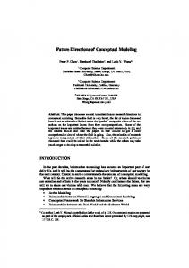
Context-specific route directions account for environmental characteristics and a route’s properties; they adapt to the current action to be taken in the current surrounding environment. They are termed context-specific because of this explicit adaptation to the structure and function in wayfinding. A computational process, called Guard, has been developed for generating them. Guard stands for Generation of Unambiguous, Adapted Route Directions. These route directions unambiguously describe one route to the destination, with instructions adapted to the environment; Figure 1 provides an overview on the process. Calculating Route
Extracting ATIs
Syntactic Chunking Postprocessing Chunks
Optimization
Context-Specific Route Directions
Figure 1: Overview on Guard, the generation process for context-specific route-directions. Guard is a four-step process. In the first step, for every decision point of the route, all instructions that unambiguously describe the route-segment to take are generated. To this end, the generation process makes use of the elements of the systematics presented in Table 1. Specifically, Guard employs references to different types of landmarks in generating instructions—namely point, linear, and areal landmarks—whose role in the route directions depend on their location relative to the route [3]. The first step of the generation process results in a set of possible instructions for each decision point; these instructions are represented in an abstract, relational format, termed abstract turn instruction (ATI). Next, Guard performs spatial chunking. Chunking covers steps two and three of the generation process. The actual chunking is done in step two. Syntactic rules are used to aggregate instructions from the sets generated in step one. However, syntactic chunking may result in chunks that are cognitively or structurally implausible. Therefore, the resulting chunks need to be validated against higher-order cognitive and structural chunking principles. This validation is performed in the third step in a postprocessing process; Guard is flexible with respect to the principles used in this step. It, for example, allows integrating the chunking principles presented by [2] or [1]. Generally, chunks are pruned of the last covered decision point until they are either valid or empty (being removed) because they do not comply to the higher-order principles at all.
In the fourth step, the actual context-specific route directions are generated. Here, from all possible instructions those that best describe the route are selected. This is realized as an optimization process; ‘best’ depends on the chosen optimization criterion. As with the chunking principles, Guard is flexible with respect to this criterion; it is possible to implement different optimization criteria. I propose to aim for directions with a minimal number of chunks (instructions) on the coarsest possible granularity level. Optimization results in a sequence of chunks that cover the complete route from origin to destination. Due to the aggregation of instructions performed in chunking, for some decision points instructions may only be represented implicitly, which reduces the communicated information.
4
Evaluation and Conclusions
Context-specific route directions have been evaluated in an exploratory human subject test in which subjects had to, first, rate route directions according to their usefulness and naturalness and, second, had to virtually follow a route using route directions by selecting the street on which to go on from photographs presented on a screen. The study shows that contextspecific route directions are clearly preferred over route-planner directions and that people are well able to find their way using these directions. The dissertation presents an approach to generating more human-like, better accepted route directions; the approach can be easily adapted to incorporate additional principles of generating good route directions due to its flexibility in the implementation. It is a step of integrating research on human direction giving done in different areas into a coherent framework for the automatic generation of route directions.
References [1]
[2]
[3]
Bild
Dale, R., Geldof, S., and Prost, J.-P. (2005). Using natural language generation in automatic route description. Journal of Research and Practice in Information Technology 37(1): 89-105. Klippel, A., Tappe, H., and Habel, C. (2003). Pictorial representations of routes: Chunking route segments during comprehension. In Freksa, C., Brauer, W., Habel, C., and Wender, K.F. (eds.), Spatial Cognition III (pp. 11-33). Berlin, Springer. Richter, K.-F. (2007). A uniform handling of different landmark types in route directions. In S. Winter, M. Duckham, L. Kulik, B. Kuipers (eds.), Spatial Information Theory (pp. 373–389). Berlin, Springer. Kai-Florian Richter is research and teaching assistant at Universit¨ at Bremen where he received his PhD. He works at the Transregional Collaborative Research Center SFB/TR 8 Spatial Cognition. He holds a diploma in Informatics specializing in knowledge representation and spatial cognition from Universit¨ at Hamburg.
Page 2