about how to apply standards and services such as SensorML and Sensor Observation Service (SOS) have to be clarified, especially for existing observation ...
12th AGILE International Conference on Geographic Information Science 2009 Leibniz Universität Hannover, Germany
page 1 of 9
Coupling Wireless Sensor Networks and the Sensor Observation Service – Bridging the Interoperability Gap Kai Walter and Edward Nash Rostock University, Faculty of Agricultural and Environmental Sciences, Institute for Management of Rural Areas, Chair of Geodesy and Geoinformatics Justus-von-Liebig-Weg 6, 18059, Rostock, Germany {kai.walter|edward.nash}@uni-rostock.de
INTRODUCTION The term Digital Earth was coined in 1998 by Al Gore proclaiming a three-dimensional multiresolution representation of the Earth’s surface holding georeferenced data of any kind (ISDE, 1998). Part of this vision is the ubiquity of observation systems, enabling a digital representation of features such as environmental phenomena with a high spatial and temporal resolution. World wide a vast amount of environmental sensors and other data producers exist, yet measurements as well as their interpretation are rarely put to proper use because of their isolated availability within a specific application domain. Using the internet as a tool for interdisciplinary data exchange, as well as for the extensive usage of heterogonous data resources is an important step towards addressing today’s larger scale environmental problems (Bacharach, 2008). By making measurements and results discoverable and accessible over the internet, producers from different areas can reduce data redundancy and existing data sets can be used to their full capacity. The Open Geospatial Consortium (OGC) addresses this requirement by developing the Sensor Web Enablement (SWE) specification series (Botts, 2007). Members of the SWE working group are specifying interfaces, protocols and data types that enable the integration of sensors and sensor webs into (spatial) information infrastructures (OGC, 2008a). While the basic concept and benefits of SWE standards, as described above, are widely accepted in the “spatial” community and are used in many programmes (Bacharach, 2008), very often questions about how to apply standards and services such as SensorML and Sensor Observation Service (SOS) have to be clarified, especially for existing observation and data producing systems, which have not previously been operating in an explicitly spatial context. The project described in the following sections uses existing commercial sensor products, implementing SWE technologies on top as a middleware layer to provide the data in an open and interoperable manner. The collaborative research project “Sensor based Landslide Early Warning System” (SLEWS) aims for the systematic development of a prototype alarm and early warning system for mass movements. Project partners are the Department of Engineering Hydrogeology at RWTH Aachen, the Federal Institute for Geosciences and Natural Resources (Hannover), the Chair of Geodesy and Geoinformatics at Rostock University and ScatterWeb GmbH (Berlin). Early warning and alarm systems are an effective tool to reduce risks from landslides (Fernandez-Steeger et al., 2008). The main goals of SLEWS are the utilisation of ad hoc wireless sensor networks and spatial data infrastructure technologies according to OGC guidelines to produce a low-cost, interoperable and performant early warning system. Methods of data access, communication and visualisation are to be implemented using SWE specifications, concurrently offering information resources via open standards to external applications while importing interoperable resources in return. The work described here is concentrated on the design and implementation of a sensor web enabled spatial data infrastructure as part of this project (Bill et al., 2008). This paper initially sums up current progress in converting sensor network data to a standardised SWE-based format to be accessed by a SOS. Based on this experience, an interoperability
12th AGILE International Conference on Geographic Information Science 2009 Leibniz Universität Hannover, Germany
page 2 of 9
gap is identified and some system models presented which may lower the implementation barrier by coupling sensor systems and SWE-based services more generically.
INFRASTRUCTURE AND MATERIALS Wireless Sensor Network The application of wireless sensor networks (WSN) provides an inexpensive and easy to implement monitoring system for landslide events. The system used in SLEWS for deploying sensor units is constructed by the project partner ScatterWeb. As a modern and autonomous ad hoc wireless sensor network it is characterised by self-organisation and self-healing capacity. Data packages from each node are sent via radio waves directly or via other nodes (multi-hop) to a collection point (gateway). Energy efficiency is achieved by reducing transmission power to only communicate with adjacent nodes. The bi-directional structure of the system enables data transfer from each node via the gateway interfaces to the main computer unit (PC, laptop, server), but also allows the transmission of commands such as data requests as well as software-updates to individual nodes or to a group of nodes (Arnhardt et al., 2007). Nodes are fitted with a range of sensors such as tiltmeters, pressure, acceleration and displacement detectors, specifically chosen to monitor engineering-geological parameters of landslide events. Due to improved manufacturing processes and progress in the area of microsensor systems, small but precise low-cost sensors can be integrated in such systems (Fernandez-Steeger et al., 2008). As a testbed WSN, a gateway and three test nodes equipped with basic temperature, motion and light detectors are being operated by one of the project partners. Measurement data can be accessed from the gateway via the computer unit (gateway server) connected to it. At this point, data is only available in a native text based format. To be available for generic SWE-enabled client applications through SOS, measurement data has to be converted into an appropriate data schema.
Sensor Observation Service Basics The SOS, as described in the OGC SWE specification series, offers a web-based interface to retrieve measurements and other data from sensors and sensor networks via spatial and temporal queries (OGC, 2008b). To understand the functionality of a SOS it is helpful to outline the SWE spatial view on the conventional sensor/measurement concept. Consistent to well-established OGC models, a sensor, as one of many possible data producers called procedure, is well-defined by a location called feature of interest. At a location an observation is recorded which represents a certain phenomenon at a certain time. Observations, analogous to a feature type offered by a Web Feature Service (WFS), are semantically grouped in offerings. Response formats of the SOS are usually the XML-based data encoding schemes SensorML and Observation & Measurement (O&M), also specified in the OGC Sensor Web Enablement specification series. SensorML is used to describe and formalise the parameters of a sensor or data producer. The way procedures are described in SensorML is strictly process-based and can be used to capture sensor metadata, operation sequences as well as software patterns of data related operations. Every procedure a SOS offers data from has to be described by a particular SensorML document, which will be returned in response to a DescribeSensor query. SensorML is thus used to enable interoperability of sensors by allowing a client to discover new sensors and to prepare for the interpretation of measurements in a hardware-independent manner. This is conceptually similar to the DescribeFeatureType operation of the Web Feature Service (WFS) interface returning the application schema.
12th AGILE International Conference on Geographic Information Science 2009 Leibniz Universität Hannover, Germany
page 3 of 9
O&M is used for the exchange of actual measurements and observations with client applications. O&M output documents can be requested by a web-based client using the GetObservation operation with options to filter all available observations by time, location, observed phenomenon or sensor. O&M is comparable with the well-established OGC format for vector data, Geography Markup Language (GML). Elements of GML are already used in O&M and the OGC SWE working group is currently attempting to fully harmonise both standards. This operation of the SOS may be compared with the GetFeature operation of the WFS interface. Software Implementation The SOS software implementation currently used for test purpose is Sensor Observation Service Version 3.0.1 provided by 52° North Initiative for Geospatial Open Source Software GmbH (Walkowski et al., 2008), The implementation is a Java-based web service package, requiring the components Jave Runtime Environment or Java Development Kit Version 1.5 (or higher), Apache Jakarta Tomcat Version 5.5 (or higher) and the spatial database system PostgreSQL Version 8.1.3/PostGIS Version 1.1.1 (or higher). An essential part of the functionality is the information schema contained in the PostGIS database. Data that is to be available through the SOS has to be adapted to an information model compatible with the SWE standards. Datasets are then used to dynamically create O&M formatted response documents. After moving the current test system to a productive state several more SOS implementations will be evaluated.
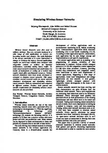
METHOD Data retrieval Gateway readout At the gateway the sensor network can be interfaced with external applications to retrieve measurement data. The gateway of the test network is physically connected to a dedicated computer unit (gateway server, see figure 1) via USB interface. A “listener” program running on the gateway server is used to access the data stream arriving at the gateway, consisting of text output representing data packages received from sensor nodes. In a simple case the listener again can be accessed via network socket by a client such as the program telnet to link to the ongoing data stream. The listener program is available with the software suite ScatterTools provided by the project partner ScatterWeb GmbH. Because ScatterTools only supports the Windows operating system, custom software for the Linux operating system had to be implemented by the project partner RWTH Aachen. To be able to store the ongoing data stream persistently the program’s functional range was then extended to interface with a database system or with a SOS via the HTTP-protocol as a feeder application. The current system architecture is outlined schematically in Figure 1.
Figure 1: Current SLEWS information infrastructure (SAS = Sensor Alert Service, SOS = Sensor Observation Service, SPS = Sensor Planning Service).
12th AGILE International Conference on Geographic Information Science 2009 Leibniz Universität Hannover, Germany
page 4 of 9
Formalising Measurement Data To be accessible to the 52°North SOS, measurement strings from the gateway have to be transformed to fit the SOS data model. A typical measurement string has the form S4 20 2008-08-13#16:14:12 2696
where S4 is the network identification number (node number 4), 20 is the sensor identification number for the specific node, followed by sampling date, time and the actual sampling value (2696, temperature sensor specific hexadecimal form). While date, time and value can be adopted almost unchanged, network and sensor identification numbers have to be resolved using previous knowledge. Knowing the identification numbers, information such as sensor location (feature of interest), sensor properties (procedure) and observed phenomena (phenomenon) can be determined. For this purpose the listener program running on the gateway server parses the original measurement string, dividing it into sub-strings using database- or file-based look-up tables (shown simplified in Table 1) to determine adequate SWE parameters. Parameter values have to be existent in XML-based O&M syntax, e.g. values for procedure and phenomenon are used in Uniform Resource Name (URN) notation. URNs, as specialised cases of Uniform Resource Identifiers (URI – W3C, 2006), serve in actual O&M documents to unambiguously identify information resources and phenomenon definitions by semantic descriptions. In summary the original dataset arriving at the gateway at runtime is extended to meet the requirements of an observation fitting into the SOS data model.
SWE parameter procedure
Node-ID: (S4)
Sensor-ID: (20)
urn:ogc:object:feature: Sensor:SLEWS:slewsMote_0.1.1
offering
Atmospheric_Temperature
phenomenon
urn:ogc:def:phenomenon: OGC:1.0.30:temperature
feature of interest
locationID: id001 descr.: Aachen sampling point 1 coord.: 50.776208,6.080085
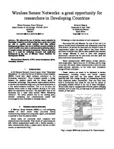
Table 1: Simplified look-up table for SWE-based parameters. SOS Data Entry Within the SLEWS project, the determined observation data set has been inserted in the SOS database in two different ways (see Figure 2). A first preliminary setup comprised a feeder service repeatedly transferring data from a transitional non-spatial database on the gateway server (RWTH Aachen) to the SOS database at Rostock University. Further improvement of this setup allowed the data entry from the feeder on the gateway server to the SOS database directly. Both setup variations require specific knowledge of the SOS database structure as well as direct access to the database via network sockets and including write permissions. Another way to insert a data set is using the SOS interface itself. Therefore the SOS’s operations must be extended to include the transactional profile. To support the transactional profile, the SOS, beside its mandatory core operations GetCapabilities, GetObservation and DescribeSensor, must offer the operations RegisterSensor and InsertObservation. The feeder service therefore is able to send a O&M-formatted data set via HTTP-request which is accepted by the SOS and automatically stored in the internal database. The advantage of data entry via SOS service interface is its interoperability.
12th AGILE International Conference on Geographic Information Science 2009 Leibniz Universität Hannover, Germany
page 5 of 9
Any data provider using proper query syntax is able to register with the SOS and supply it with data sets without previous knowledge. A transactional profile is supported by the 52°North implementation of the SOS.
Gateway Server
SOS
Raw Data from WSN Gateway S4202008-08-13#16:14:122774 S2102008-08-13#16:15:301891 S4052008-08-13#16:15:303712 S1102008-08-13#16:15:459474 S1202008-08-13#16:16:125543 S3202008-08-13#16:16:302696
Listener H
Parser Feeder
ST -P O P TT TP
SOS-T Service Interface
SOS Service Interface
HT
SQL-Insert Network
PostGIS DB
Figure 2: Importing data from the sensor-system layer into the Sensor Observation Service.
DISCUSSION OF ALTERNATIVE IMPLEMENTATIONS The vision of the SWE-initiative is to create standards as a foundation for "plug and-play" webbased sensor networks (Botts, 2007). However connecting sensors as data providers to SWE-based services remains a difficult task requiring detailed knowledge of both the sensor network’s native format and of the SWE standards, and off-the-shelf WSN do not support SWE standards. As the experience in the SLEWS project, shown in detail in the previous sections, this leaves an interoperability gap which must be bridged by anyone wishing to provide an SOS with live sensor data. Even though the use of a transactional SOS benefits interoperability at the service side, reformatting sensor specific data sets to fit a SWE-based layout still requires a high amount of work, depending on the type of systems that are used and the output formats they support. In order to advance the widespread usage of SWE standards in the sensor community, however, adaptive and reusable methods to interface sensor data and SWE services should be developed. There are a number of feasible approaches to this problem – here we present two potential models for future developments.
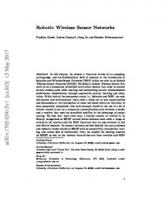
Sensor-system layer based standardisation A common misconception of the adoption of SWE standards is that they, instead of encapsulating sensor information on application level, were originally designed to operate directly on a hardware level. However, supporting interoperable access on the hardware level has advantages and comes very close to the concept of “plug and play”-capability. Current sensor systems such as weather stations and observation cameras already offer access to data resources through integrated webservers (e.g. XServe from Crossbow Technologies (Crossbow, 2009)). Related efforts within the Institute of Electrical and Electronics Engineers (IEEE) are concentrating on connecting output of physical detector units to the network level (smart sensors/IEEE 1451, see Song et al., 2008). Those efforts are coordinated closely with the OGC to combine the specification series SWE and IEEE 1451 (Lee et al., 2005). Offering formalised or even SWE-formatted data close to the physical layer could therefore be a feasible approach. Within the context of the SLEWS architecture the gateway, taken as part of a WSN macro sensor system, could provide observations as O&M-formatted output (as shown in Figure 3) or could even host an additional feeder application to convey data directly to the SOS. Assum-
12th AGILE International Conference on Geographic Information Science 2009 Leibniz Universität Hannover, Germany
page 6 of 9
ing an adequate system performance, gateways or other already web-enabled sensor systems mentioned above could even implement a SOS themselves. The downside of this approach however is the coupling of hardware and application layer, contradicting the view of OGC SWE uncoupling sensor information from sensor systems. Furthermore, benefits seem doubtful taking the great number of highly specialised sensor systems into account. Especially in a resource-limited scenario, as present within a typical WSN, communication and data transportation operations have to be highly optimised. Even the relatively powerful sensor gateway is not necessarily suitable as a web server – in many cases it may typically be networked via a GSM network and powered by a 12V battery and so has neither the energy or bandwidth resources required to provide a webservice interface. Conveying continuous data streams near real-time is a necessity in an early warning context. Adding operations such as parsing, reformatting and adding parameters would impact resource-efficiency and multiply the transported data traffic and required bandwidth by a large amount. A further problem is that parameters necessary for SWE-based formatting such as location coordinates of a sensor system without self-positioning capabilities may only be available after the post-processing of observation data.
SOS SOS-T
HT
TP
WNS
WSN
SWE Services
Gateway
Network socket
Raw Data Domain
GIS-Client WebGIS-Client Analysis-Client Web Processing Service E-Mail Chat Session GSM Short Message
PostGIS DB
SWE Data Domain
Figure 3: Layout of a sensor-system layer based SWE standardisation process (SOS-T: transactional SOS; WNS: Web Notification Services).
Application layer based standardisation Moving the connection process between sensor and SWE services to the application level to attain sufficient processing capacity or reduce workload on a possibly resource-limited system is an adequate approach, supporting the clean separation envisioned by the OGC. However, pushing the SWE connection too far to the service side is likely to result in a lack of interoperability in the necessary middleware layer between sensors and the service backend, as demonstrated in the SLEWS project. Using dedicated webservice-based feeder services as currently developed by 52°North (52° North, 2008) to mediate between data models of provider applications or sensor systems and transactional/non-transactional SOS is an important approach towards “plug&play”-capability. However, such feeder services, taking the need for a high number of specialised sensor connectors into account, should only act as an intermediary and start with a largely standardised or SWE-based
12th AGILE International Conference on Geographic Information Science 2009 Leibniz Universität Hannover, Germany
page 7 of 9
format. Even with this model, implementing solutions to convert a proprietary sensor format into a SWE-based format is still unavoidable and requires detailed knowledge of the relevant parts of both platforms.
WSN
H TT P
H
P TT H
WSN
TT P
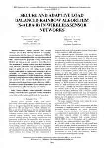
In order to overcome this problem, we propose that a dedicated lightweight “SWE connector” application should be developed, supplying generic tools for database-, file- or stream-based data parsing and supporting data management to expand raw sensor data with static and variable SWE parameters. Taking intensiveness of data traffic into account the output of the connector should not necessarily be O&M-formatted but in an intermediary lightweight format (analogous to WKB (OGC, 2008c)) which could easily be parsed and remodelled by a feeder service application to populate an SOS backend database (Figure 4). Intended to be a compact application “SWE connector” could be deployed locally, as for example on the SLEWS project’s gateway server, and could even be, if a webservice-based environment is required, executed as a plugin servlet linked dynamically to a feeder service.
Figure 4: Layout of an application layer based SWE standardisation process (SOS-T: transactional SOS; WNS: Web Notification Services).
CONCLUSIONS AND FUTURE WORK The services and models produced by the SWE initiative provide effective tools to realise the concept envisioned by the OGC of uncoupling sensor information from the way they are collected and to make this information available over the web using standardised formats and interfaces. Work within the SLEWS project to use SWE technologies as an interoperable middleware layer on top of an offthe-shelf WSN in order to implement an alarm- and early warning system for mass movements has clearly identified an interoperability gap between data (WSN hardware) and service (software for OGC standards) providers. Generic interfacing between data providers such as sensor systems and services such as SOS still presents an obstacle which must be overcome to provide flexible “plug&play” solutions. First steps towards closing the gap are being taken with the utilisation of transactional SOS and multifunctional webservice-based feeder services, mapping observation data to the data model of the service backend. Further efforts in this process must be made focussing on the earlier stages of the data delivery chain. The result should be an easier combination of sensors and services by seamlessly translating the high number of different sensor-native formats from data providers to a SWE-enabled format. Therefore we suggest a lightweight “SWE connector” application, providing a generic toolbox which can be adapted to a raw format and converted to an initial SWE-based data model. Taking system performance and real-time awareness into account this data transfer should not necessarily use O&M but rather a lightweight intermediary format similar to the WKB representation for simple feature geome-
12th AGILE International Conference on Geographic Information Science 2009 Leibniz Universität Hannover, Germany
page 8 of 9
tries. Customised “SWE connector” applications could be designed for a wide range of different sensor systems to interact dynamically with feeder services in the form of servlet plug-ins. Current work within the SLEWS project is concentrating on the evaluation of different approaches, amongst others than those presented in this paper. Different architectures and application implementations will focus on interfacing sensor network and information services effectively. In the context of a time-aware alarm and monitoring system the principle usefulness of certain SWE technologies have to be determined. Further work will be focused on establishing bi-directional communication with the sensor network via a webservice interface, for e.g. controlling system internal processes such as measuring cycles and energy management via Sensor Planning Service (SPS). Furthermore, implementation of landslide event-based data analysis and decision management processes will be tested using a system architecture based on the coupling together of SWE services with further OGC webservice-based visualisation and notification technologies.
ACKNOWLEDGEMENTS This work was funded by the German Federal Ministry for Research and Education under grant number FKZ: 03G0662A. The authors would also like to thank colleagues from within the SLEWS project who have assisted with aspects of this work.
BIBLIOGRAPHY 52° North Initiative for Geospatial Open Source Software GmbH (2008): Integration of different data sources into 52N SOS. URL: http://www.gitage.de/archive/2008/downloads/Material/geosensornetworks/52N_SWE_SOS_Feeder.pdf (accessed 14/01/2009) Arnhardt, C.; Asch, K.; Azzam, R; Bill, R.; Fernandez-Steeger, T.M.; Homfeld, S.D. ; Kallash, A.; Niemeyer, F; Ritter, H.; Toloczyki, M.; Walter, K. (2007): Sensor based Landslide Early Warning System - SLEWS. Development of a geoservice infrastructure as basis for early warning systems for landslides by integration of real-time sensors.- GEOTECHNOLOGIEN Science Report 10. Early Warning Systems in Earth Management, 75 – 88 Bacharach, S. (2008): Sensors and the Environment. In: Vector 1 Magazine – Promoting Spatial Design for a Sustainable Tomorrow. URL: http://www.vector1media.com/article/feature/sensors-and-the-environment/ (accessed 14/01/2009) Bill, R.; Niemeyer, F.; Walter, K. (2008): Konzeption einer Geodaten- und Geodiensteinfrastruktur als Frühwarnsystem für Hangrutschungen unter Einbeziehung von Echtzeit-Sensorik. GIS, Zeitschrift für Geoinformatik 1/2008 26-35. Botts, M. (2007): OGC White Paper – OGC Sensor Web Enablement: Overview and High Level Architecture.- Version 3. URL: http://www.opengeospatial.org/pressroom/papers (rev.: 28.12.2007). OGC 07-165. Crossbow (2009). Gateway Middleware. http://www.xbow.com/Technology/GatewayMiddleware.aspx (accessed 14/01/2009).
URL:
Fernandez-Steeger, T.M.; Arnhardt, C.; Niemeyer, F.; Haß, S. E.; Walter, K.; Homfeld, S. D.; Nakaten, B.; Post, C.; Asch, K.; Azzam, R.; Bill, R.; Ritter, H.; Toloczyki, M.: Current Status of SLEWS - a Sensor Based Landslide Early Warning System. In: Universitätsgesellschaft
12th AGILE International Conference on Geographic Information Science 2009 Leibniz Universität Hannover, Germany
page 9 of 9
Osnabrück e.V. : R & D - Programme Geotechnologien Status Report. Early Warning Systems in Earth Management, 2008 Lee, K. B., Reichardt, M. E. (2005): Open standards for homeland security sensor networks, IEEE Instrum. Meas. Mag., vol. 8, no. 5, pp. 14–21, Dec. 2005. ISDE (1998): International Symposium on Digital Earth. The Digital Earth: Understanding our planet in the 21st Century by http://www.isde5.org/al_gore_speech.htm (accessed 14/01/2009) OGC
(2008a): Sensor Web Enablement WG http://www.opengeospatial.org/projects/groups/sensorweb
Al
Gore.
Homepage.
URL: URL:
OGC (2008b): Sensor Observation Service / Na, Arthur (IRIS Corp.); Priest, Mark (3eTI). URL: https://portal.opengeospatial.org/modules/admin/license_agreement.php?suppressHeaders=0 &access_license_id=3&target=http://portal.opengeospatial.org/files/index.php?artifact_id=26 667 (rev.: 26.10.2007, accessed 14/01/2009) OGC (2008c): OpenGIS Implementation Specification for Geographic information - Simple feature access Part 1: Common architecture. URL: http://portal.opengeospatial.org/files/?artifact_id=18241 (rev.: 05/10/2006, accessed accessed 14/01/2009) Song, E. Y., Lee K. B. (2008): STWS: A Unified Web Service for IEEE 1451 Smart Transducers. IEEE Transactions on Instrumentation and Measurement 57 (8) 1749-1756. Walkowski, C. A.; Stasch, C.; Künster, S. (2008): Sensor Web Enablement - Installation and Developement Guide for Sensor Observation Service version 3.0.0. URL: http://52north.org/joomla/images/stories/52n/communities/swe/how2install_SOS-3.00.00.pdf (rev.: 11.02.2008, accessed 14/01/2009) W3C (2006): Naming and Addressing: URIs, URLs, ....URL: http://www.w3.org/Addressing/ (accessed 14/01/2009)