Cusseque - Microclimate. The Cusseque core site is embedded in a rolling landscape with a perpendicular stream network. While the hills are covered by ...
Cusseque - Microclimate The Cusseque core site is embedded in a rolling landscape with a perpendicular stream network. While the hills are covered by Miombo forests and woodlands, the valley bottoms feature wetland vegetation. The striking features of this landscape, however, are the midand foot-slopes covered by open vegetation dominated by subterraneous shrubs and grasses. White (1976) describes the phenomenon of dwarf shrubs with an enormous woody underground biomass within the Zambezian Region and coins the term “geoxylic suffrutex” for this growth form. In order to investigate the extent to which micro-climatic conditions shape vegetation patterns and limit agricultural use, a network of 21 micro-climatic measuring stations was installed (Fig. 1). The stations are distributed along three catenas extending from the woodlands on
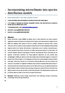
the hills through the dwarf shrub grasslands on the slopes down to the wetlands. Each station was equipped with a Gemini Tinytag® data logger measuring air temperature and air humidity at a height of 30 cm above the ground. At selected sites additional Gemini Tinytag® soil temperature loggers were installed at a soil depth of 10 cm. All stations provided a set of measurements at an interval of 15 minutes (Fig. 2). In this paper data from three representative measuring stations in the Sovi Valley are presented: one from the wetlands (TT01, Fig. 3) at the valley bottom, one from the mid slope (TT04, Fig. 4) and one from woodlands on the hills (TT06, Fig. 5). During the period 1st June 2012 – 31st May 2013, the lowest measured temperature was -6.3°C while the warmest temperature was 40.5°C. Daily minimum
temperatures were constantly lower on the slopes than in the woodlands with only a few exceptions during the summer months. The same holds true for the comparison between the wetlands and woodlands. Comparing the wetlands with the slopes shows that temperatures are rather similar with the slopes being slightly warmer except for the coldest days of the year. Frost occurred on 21 days on the slopes, 19 days in the wetlands and on only two days in the woodlands. Frost conditions always ended shortly after sunrise (Fig. 2). Soil temperatures display a less pronounced amplitude than air temperatures. Frost never occurs in the upper soil layers; in fact, soil temperatures never dropped below 10°C at any location. While soil temperatures display a strong diurnal pattern in the dwarf shrub grasslands and in the woodlands, the soil
Fig. 1: Location of micro-climate data loggers in the Cusseque core site.
In: Oldeland, J., Erb, C., Finckh, M. & Jürgens, N. (2013) [Eds.]: Environmental Assessments in the Okavango Region. – Biodiversity & Ecology 5: 47–50. DOI: 10.7809/b-e.00244.
47
A
B
C
temperature in the wetlands exhibits a seasonal pattern. The high water content of the peat leads to a very balanced temperature regime with an average daily amplitude of only 1.7°C. In contrast, the average daily temperature amplitude is 6.0°C in the woodland and 10.6°C in the dwarf shrub grasslands (Fig. 2). The data from these three measuring stations show that there is a nocturnal flow of cold air converging in the valleys during the dry season. Clear skies during nighttime in the months May to September facilitate outgoing longwave radiation, resulting in accumulation of cold air close to the soil surface and increasingly low air temperatures as the night progresses, reaching minima just before sunrise. Hence, frosts never lasted longer than 12 hours (Fig. 6). From personal observations, day-time skies are also usually clear during the dry season, leading to high temperatures during the day. Consequently, the temperature amplitude is much bigger in the dry season than during the wet season. In conclusion, it can be stated that there are distinct terrain and vegetation related microclimatic differences within the Cusseque core site. This has considerable implications for vegetation patterns as well as for agriculture, especially in the case of tropical, frost-sensitive crops such as cassava, sweet potatoes, corn or tropical fruits like bananas and mangos. Although there is no frost occurring in the soil, temperatures below 0°C in the atmospheric layers close to the ground during the dry season clearly limit the potential of agricultural activities in the wetlands and demand cautious site selection for perennial tropical crops on the hills.
Fig. 2: Bivariate difference plot depicting daily minimum and maximum air temperature at 30 cm above ground and soil temperature at 10 cm depth from 1st June 2012 to 31st May 2013. (A) Peatland at TT01, blue denotes air temperature; brown refers to soil temperature. (B) Dwarf shrub grassland at TT04; orange denotes air temperature; brown refers to soil temperature. (C) Woodland at TT06; green denotes air temperature; brown refers soil temperature.
48
Biodiversity & Ecology 5
2013
Fig. 3: Microclimate measuring station in wetland in the Sovi valley (TT01, photo: R. Revermann).
Fig. 4: Microclimate measuring station in dwarf shrub grassland in the Sovi valley (TT04, photo: R. Revermann).
Fig. 5: Microclimate measuring station in Miombo woodlands in the Sovi valley (TT06, photo: R. Revermann).
Biodiversity & Ecology 5
2013
49
Fig. 6: Morning fog lifting from the valleys, with Sovi River in the foreground and the large valley of Cusseque River in the background (photo: M. Finckh).
Acknowledgments We acknowledge the DLR for the provision of the data from the RapidEye Science Archive. This study was funded by the BMBF (The Future Okavango project). For details see authors' general acknowledgements in this volume.
Reference White F. (1976): The underground forests of Africa: a preliminary review. – The Gardens' Bulletin Singapore 11: 57–71.
Responsible authors: R. Revermann, M. Finckh
50
Biodiversity & Ecology 5
2013