Decision Support System for Designing Integrated Coastal Berths and Entrance-Channel Systems
Downloaded from ascelibrary.org by Zijian Guo on 07/21/16. Copyright ASCE. For personal use only; all rights reserved.
Guolei Tang1; Wenyuan Wang2; Zijian Guo3; Xiangqun Song4; Xuhui Yu5; and Yonghao Zhang6 Abstract: The design of an integrated coastal berths and entrance-channel system is a complex challenge, considering the stochastic environment and time-consuming calculation works. Therefore, the authors implement a decision support system (DSS) for designing integrated coastal berths and entrance-channel systems (ICBECS-DSS) by means of simulation and parallel computing. The ICBECS-DSS provides a three-dimensional (3D) integrated design environment with a broad set of fully integrated functions to evaluate the proposed design alternatives, and to identify an optimal design from a large number of alternatives. The key components of ICBECS-DSS are a process interaction– based simulation model for ship operation (PI-SMSO) and a Java parallel processing framework–based parallel computing program (JPPFPCP). The PI-SMSO component simulates ships in and out of a one- or two-way traffic channel, or a one-way channel with a ships-passing anchorage along the channel (SPAC), and ships discharging/loading at berths. The JPPF-PCP component provides a parallel computing environment to reduce their processing time of running a large number of simulation experiments. Finally, the ICBECS-DSS is applied to a case study of a coal terminal, decides whether any expansion projects are needed, and proposes expansion strategies to improve its port performance. The results prove that the ICBECS-DSS performs well and is helpful for effectively designing berths and entrance channels together. Therefore, the ICBECS-DSS can be used for support in decision making in integrated berths and entrance-channel systems and provides a reference for government agencies involved with the design and operation of port systems. DOI: 10.1061/(ASCE)WW.19435460.0000356. © 2016 American Society of Civil Engineers. Author keywords: Entrance channel; Decision support system; Stochastics; Simulation; Parallel computing.
Introduction A coastal entrance channel is a navigable channel linking the berths of a port and the open sea that is required to provide safe and convenient navigation for vessels. Recently, the rapid increase in the number and size of ships calling at ports puts a premium on minimizing time in port, which leads to further pressures on the berths 1 Associate Professor, State Key Laboratory of Coastal and Offshore Engineering, Faculty of Infrastructure Engineering, Dalian Univ. of Technology, Dalian 116023, Liaoning, China. E-mail: tangguolei@outlook .com 2 Lecturer, State Key Laboratory of Coastal and Offshore Engineering, Faculty of Infrastructure Engineering, Dalian Univ. of Technology, Dalian 116023, Liaoning, China. E-mail:
[email protected] 3 Professor, State Key Laboratory of Coastal and Offshore Engineering, Faculty of Infrastructure Engineering, Dalian Univ. of Technology, Dalian 116023, Liaoning, China (corresponding author). E-mail:
[email protected] 4 Professor, State Key Laboratory of Coastal and Offshore Engineering, Faculty of Infrastructure Engineering, Dalian Univ. of Technology, Dalian 116023, Liaoning, China. E-mail:
[email protected] 5 Ph.D. Candidate, State Key Laboratory of Coastal and Offshore Engineering, Faculty of Infrastructure Engineering, Dalian Univ. of Technology, Dalian 116023, Liaoning, China. E-mail: yuxuhui_9117@163 .com 6 Masters’ Degree Candidate, State Key Laboratory of Coastal and Offshore Engineering, Faculty of Infrastructure Engineering, Dalian Univ. of Technology, Dalian 116023, Liaoning, China. E-mail: zhangyonghaodlut@ 163.com Note. This manuscript was submitted on September 25, 2015; approved on May 16, 2016; published online on July 20, 2016. Discussion period open until December 20, 2016; separate discussions must be submitted for individual papers. This paper is part of the Journal of Waterway, Port, Coastal, and Ocean Engineering, © ASCE, ISSN 0733950X.
© ASCE
and entrance-channel design (MTPRC 2014; PIANC MarCom Working Group 121 2014). For example, to accommodate everlarger ships, the Senate Appropriations Committee appropriated a total of $33.5 million in funding for the Houston Ship Channel deepening and widening project, which widened the channel from 122 to 162 m and deepened it from 12.2 to 13.7 m (Lardas 2013; Tang et al. 2014b); to minimize restrictions on channel accessibility, Guangzhou Port Group will invest $484 million to expand the 66.6-km entrance channel into two-way traffic for container ships of 100,000 dead-weight tons (DWT) (Yu 2015). As discussed in Tang et al. (2016), the berths and entrance channel are interlinked, and must be optimized together to avoid possible bottlenecks for the port’s future performance. To achieve a harmonized overall design, the elements of integrated berths and entrance system (e.g., the number of berths, channel alignment, width and depth) must all be considered together, which will lead to a large number of channel alternatives. Moreover, evaluating the port performance (e.g., ship waiting time and berth utilization ratio) is another challenge for the designers, because the port system is a stochastic system with multiple random factors and dynamic relations (Quy et al. 2008; Tang et al. 2014b). Thus, the design of such an integrated system is a timeconsuming and nerve-wracking affair for the designers, because they have to deal with large and complex studies of the estimated port performance of various design alternatives under a stochastic environment. Therefore, a decision support system (DSS) is necessary to relieve the designers from time-consuming calculations, and to evaluate and optimize an overall design in an efficient and automatic way. The reliability of berths and channels is not only of immense importance to commercial navigation but is also vital to national defense interests. So to provide efficient and safe operation, MTPRC (2014), PIANC MarCom Working Group 121 (2014), ASCE (McCartney et al. 2005), and CCG (2001) provide a set of
04016013-1
J. Waterway, Port, Coastal, Ocean Eng., 04016013
J. Waterway, Port, Coastal, Ocean Eng.
Downloaded from ascelibrary.org by Zijian Guo on 07/21/16. Copyright ASCE. For personal use only; all rights reserved.
design guidelines and procedures to determine all interlinked elements of an integrated berths and channel system. However, conventional analytical methods may fail to evaluate navigation efficiency due to the stochastic characteristics of the port system (Quy et al. 2008; Tang et al. 2014b; Bellsolà Olba et al. 2015). Therefore, most researchers have applied computer simulation to estimate the capacity and efficiency of berths and entrance channels and optimize one or more elements of the integrated berths and channel system. For example, Kia et al. (2002) and Wu (2011) applied computer simulation to evaluate the impact of handling techniques on terminal capacity/occupancy; Tang et al. (2006) analyzed the relationship between the container terminal efficiency and the number of berths by discrete event simulation; Groenveld (2001) and Guo et al. (2010) measured the channel capacity based on the required service level by a ship operation simulation model; Groenveld (2006) built traffic flow simulation models to estimate the capacity of the wet infrastructure of the Maasvlakte 2 of Rotterdam Port; Pachakis and Kiremidjian (2003) presented a modeling methodology of ship traffic in a container port based on statistical analysis of container-ship traffic and cargo data; Almaz and Altiok (2012) built a simulation model of the vessel traffic in the Delaware River to study the impact of deepening on navigational efficiency; and Gucma (2015) presented a new systematic approach to studying sea waterways with computer simulation methods. To optimize berth number or channel dimensions, Özgüven et al. (2013) built a stochastic knapsack model to optimize berth numbers by maximizing the benefits of port operators while guaranteeing the service level for ship owners; and Quy et al. (2008) optimized channel depth for Cam Pha Coal Port, taking into account downtimes, ship operation, and investment costs. To reduce dredging frequency and dredged material volume for water-quality benefits, McAnally et al. (2015) discussed the application of the nautical depth in U.S. waterways; and Tang et al. (2014b) proposed a simulation-based optimization framework to optimize channel dimensions and sailing speed in an integrated way. Moreover, to relieve the designers from time-consuming calculations and improve design efficiency, Ince and Topuz (2004) implemented a vessel traffic management and information system (VTMIS) for the Turkish Straits to aid safe and efficient navigation through narrow waterways; and Briggs et al. (2012, 2013) presented a channel-analysis and design-evaluation tool (CADET) to determine the optimum dredge depth for entrance channels, which is the depth with the greatest number of days of accessibility per year and the least amount of dredging. Dredge3D, a scientific visualization and calculation package for hydrographic survey and dredging, provides a three-dimensional (3D) visualization of hydrographic survey data with contouring and dredge drawing and real-time updates for dredge position from global positioning system (GPS) data. These researches and computer-aided design systems/software provide invaluable insights regarding design criteria (e.g., port performance indicators or optimization models) and implementation of a DSS for designing integrated coastal berths and entrance-channel systems. However, to the best of the authors’ knowledge, literature related to the DSS for designing such an integrated system is quite scarce, because these researches mainly focus on the simulation models for ship operation or the optimization models of one or more elements of the integrated berths and entrance-channel systems. As a consequence, this study implemented a DSS for designing integrated coastal berths and entrance-channel systems (ICBECSDSS) based on 3D visualization, process-interaction simulation, and parallel computing. First, a process interaction–based simulation model for ship operation (PI-SMSO) was developed, which involves moving in and out of a port through entrance channels and handling cargoes at berths, and automatically evaluates the performance of the © ASCE
stochastic port system. Second, a Java parallel programming framework–based parallel computing program (JPPF-PCP) (Cohen 2015) was also implemented, which automatically splits the large number of simulation runs into smaller parts and executes them on any number of computers simultaneously. The ICBECS-DSS aims to provide the designers with an efficient and automatic 3D integrated design environment, which integrates data analysis and modeling, engineering calculation (e.g., berth capacity, minimum channel dimensions, construction costs), 3D visualization of geotechnical conditions and seabed bathymetry, and cost/benefit estimates to achieve a harmonized overall design. Finally, the effectiveness and applicability of the ICBECS-DSS is supported by a case study conducted at a coal terminal in China. The remainder of this paper is organized as follows. First, the challenges the designers faced in designing an integrated berths and entrance-channel system are discussed along with its design criteria. Next, this study proposes an ICBECS-DSS and gives a detailed implementation of PI-SMSO and JPPF-PCP. Then, the proposed ICBECS-DSS is applied to a case study of a coal terminal, and its results are discussed. Finally, concluding remarks, discussions on the advantages and limitations, and future extensions of this research are presented.
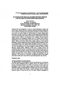
Problem Description Design Criteria As shown in Fig. 1, the typical elements of an integrated berths and entrance-channel system include the number of berth types (i; nbth,i, I P and N ¼ nbth;i , where I is the number of berth types, and N is the i¼1
total number of berths), channel alignment (a), width (W), depth (D), design navigable water level (Znwl), length (Lc), and side slopes (1: m or 1: n). According to MTPRC (2014), port performance indicators or optimization models are used as design criteria to select an optimal design from various design alternatives. Port Performance Indicators Port performance measures the quality of service provided by ports, which are used to select an optimal design alternative (Groenveld 2001; PIANC MarCom Working Group 121 2014). The most-used indicators are (1) average turnaround time (ATAT) (UNCTAD 1985; Rabadi et al. 2007), (2) average waiting time (AWT) (Shabayek and Yeung 2002; Tang et al. 2014b), (3) average service time (AST) (UNCTAD 1985), (4) waiting time/service time ratio (AWT/AST) (UNCTAD 1985; Shabayek and Yeung 2002), and (5) berth utilization ratio ( r ) (UNCTAD 1985; Shabayek and Yeung 2002; Mwasenga 2012). The ATAT is the total time between ship arrival and departure, which portrays the port capability and the ability to provide services with high productivity and performance (UNCTAD 1976, 1985; Rabadi et al. 2007). The AST is the total time between berthing and departure, which depends on the quantity of cargoes loaded or discharged, the type and characteristics of the vessel, and the equipment and other resources used at the berth. The AWT is the total waiting time for the availability of a berth (AWTB) and the entrance channel (AWTC) and, normally, a small proportion of ATAT (Shabayek and Yeung 2002, Tang et al. 2014b). AWT/AST is the ratio of the AWT to the AST, which is widely used as a measure of the level of service provided by a terminal (UNCTAD 1985; Shabayek and Yeung 2002). The berth utilization ratio is the ratio of time the berth is occupied by vessels to the total time available. High berth occupancy is a
04016013-2
J. Waterway, Port, Coastal, Ocean Eng., 04016013
J. Waterway, Port, Coastal, Ocean Eng.
Znwl
Znwl
1 m
D
D
1
Zdl
1
n
W
(b)
1
Zdl
m
n
W
(c)
Navigable water level
Znwl
Original bed level
Zol
Designed depth level
Zdl
D
Downloaded from ascelibrary.org by Zijian Guo on 07/21/16. Copyright ASCE. For personal use only; all rights reserved.
(a)
Lc (d)
Fig. 1. Berths and alignment and dimensions of an entrance channel: (a) channel alignment; (b) cross section of a one-way traffic channel; (c) cross section of a two-way traffic channel; (d) longitudinal section of an entrance channel
sign of congestion (>70%) and hence a decline of services, whereas low berth occupancy signifies underutilization of resources (