1
1
Detecting spirit-levelling errors in the AHD:
2
recent findings and issues for any new
3
Australian height datum1
4 5
M.S. FILMER* AND W.E. FEATHERSTONE
6 7
Western Australian Centre for Geodesy & The Institute for Geoscience Research,
8
Curtin University of Technology, GPO Box U1987, Perth WA 6845, Australia,
9
* Tel: (08) 9266 2218; Fax: (08) 9266 2703; Email:
[email protected]
10 11
The Australian Height Datum (AHD) forms the vertical geodetic datum for Australia
12
and is thus the framework for all heights, including those used to establish digital
13
elevation models (DEMs). The AHD was established over quite a short timeframe,
14
due to the urgent requirement for height control for topographic mapping and
15
gravity surveys.
16
observations over long distances and approximate data reductions.
17
Australia has kindly supplied us with height differences for all sections of the basic
18
and supplementary spirit-levelling used to establish the AHD, allowing us to analyse
19
loop closures to detect spirit-levelling (or data entry / transcription) errors in this
20
dataset.
21
gravimetric quasigeoid model can be used to identify the sections in a levelling loop
22
that cause misclosure, reflecting the relative quality of modern quasigeoid models
23
over the spirit-levelling originally used to establish the AHD. We also consider and
24
discuss some of the other issues that would have to be considered if Australia is to
25
implement a new vertical geodetic datum from these data to support, for example,
26
improved DEMs in the future.
This necessitated the use of lower quality spirit-levelling Geoscience
In the case-studies presented here, we show that GPS and a precise
27 28
KEY WORDS: Heights, AHD, spirit-levelling, geoid, GPS, DEMs
29
1
DISCLAIMER: Please note that the Intergovernmental Committee on Surveying and Mapping has
decreed that the AHD will be retained for the foreseeable future, so our experiments are only to ascertain what can be achieved, rather than foreshadowing any revision to the AHD in the near future.
Australian Journal of Earth Sciences (submitted)
2
30
INTRODUCTION, BACKGROUND AND MOTIVATION
31
Since 1971, the Australian Height Datum (AHD) (Roelse et al., 1971, 1975; also see
32
National Mapping Council (NMC, 1986, chapter 8) and Inter-governmental Committee
33
on Surveying and Mapping (ICSM, 2002, chapter 8)) has formed the framework for
34
heights on the Australian mainland as the gazetted [legal] vertical geodetic datum. The
35
Australian Levelling Survey (ALS, Roelse et al, 1971, 1975), which provided the data
36
used to establish the AHD(Mainland), took place between 1945 and 1970. Of the
37
161,000 km of spirit-levelling completed by 1970, ~113,000 km was levelled between
38
1960 and 1965, with a further ~32,000 km between 1966 and 1970 (Roelse et al., 1971,
39
1975, chapter 2.1). The impetus for the completion over a reasonably short timeframe
40
came from the requirement to provide geodetic control for national mapping projects
41
(e.g., Lines, 1992), i.e., precisely determined heights (see Annex H of Roelse, 1971,
42
1975) as the framework for topographic mapping, and indeed any other application for
43
which heights are needed in Australia.
44
However, the integrity of the AHD as a reliable framework for heights has
45
continually attracted the interest of scientists before and after its realisation (e.g.,
46
Angus-Leppan, 1975; Coleman et al., 1979; Featherstone, 1998, 2001, 2004, 2006;
47
Featherstone and Filmer, 2008; Featherstone and Kuhn, 2006; Featherstone and
48
Sproule, 2005; Featherstone and Stewart, 1998; Gilliland, 1986; Hamon and Greig,
49
1972; Holloway, 1988; Johnston and Luton, 2001; Kearsley et al., 1988, 1993; Leppert,
50
1967; Leppert et al., 1975; Macleod et al., 1988; Mitchell, 1973a,b,c, 1988, 1990;
51
Morgan, 1992; Soltanpour et al., 2006). There is also a small (~12-26 cm) offset
52
between the mainland and Tasmania (Rizos et al., 1991, Featherstone, 2000).
Australian Journal of Earth Sciences (submitted)
3
53
The AHD is used – implicitly or explicitly – in many Earth-science-related
54
applications (cf. Vaníček et al., 1980). For instance, digital elevation models (DEMs)
55
are used in Australia for resource and environmental management (e.g., Carroll and
56
Morse, 1996; Ludwig et al., 2007; Walker et al., 2006), river geomorphology and
57
hydrological modelling (e.g., Hutchinson and Dowling, 1991; Reinfelds et al., 2004;
58
Jain et al., 2006; Verstraeten et al., 2007), height-change analysis associated with
59
seismicity (e.g., Wellman and Tracey, 1987; Dentith and Featherstone, 2003), and the
60
computation of gravimetric terrain corrections (e.g., Kirby and Featherstone, 1999;
61
2002; Kuhn et al., 2008). However, Hilton et al. (2003) showed that several of the
62
DEMs available for Australia are deficient when compared to independent data. The
63
AHD may be part of the cause for erroneous DEMs, especially as it forms the geodetic
64
backbone of them.
65
Several causes for the deficiencies in the AHD have been proposed, which now
66
show rather convincingly that there is a north-south slope of ~1.5m due to the mean sea-
67
level constraints applied to the least-squares adjustment of the ALS (e.g., Featherstone,
68
2004, 2006), but the quality of the spirit-levelling observations and their reductions
69
remain a contributing factor. While this north-south slope is seemingly small, it may be
70
significant to some Earth-science-related studies, notably high-precision geodesy.
71
Here, we report results of an examination of spirit-levelling loop misclosures
72
using a dataset combining the basic (Figure 1) and supplementary (Figure 2) spirit-
73
levelling used to establish the AHD. The advantage of using all spirit-levelling together
74
in this way is that it adds redundancy that better detects errors. This treatment is unlike
75
the original establishment of the AHD in 1971, where the basic levelling was adjusted
76
in stages and then the supplementary levelling adjusted onto this framework (Roelse et
Australian Journal of Earth Sciences (submitted)
4
77
al., 1971, 1975); a strategy devised to overcome the lack of computing capacity at that
78
time and the need to establish a vertical geodetic datum in a short timeframe.
79 80
Figures 1 and 2 near here
81 82
Analysis of the spirit-levelling loop closures using the basic and supplementary
83
spirit-levelling together adds robustness to the identification of sections that cause a
84
loop to exceed the third-order tolerance of the AHD (cf. Morgan, 1992; ICSM, 2002).
85
For instance, the dense supplementary levelling networks in south-west Western
86
Australia add significant redundancy (cf. Figures 1 and 2).
87
It should be noted that the AHD uses an approximation of the normal-
88
orthometric height system (Holloway, 1988; Featherstone and Kuhn, 2006), so that the
89
assumption of holonomity (cf. Sansò and Vaníček, 2006) is violated. However, given
90
the difference between the tolerance for class-LC levelling (ICSM, 2004) over the
91
generally long sections used in the AHD (Figure 1) compared to the relatively small
92
(cm level) orthometric correction (cf. Allister and Featherstone, 2001), this theoretical
93
inconsistency can be neglected in this investigation.
94
We report results of experiments to isolate unexpectedly large misclosures in
95
some of the levelling loops in the ALS database supplied by Geoscience Australia
96
(GA). We consider these unexpected because they are beyond the tolerance set for
97
class-LC spirit-levelling (ICSM, 2004), which should have been rejected before the
98
AHD was established, although Roelse et al. (1971, 1975) concede that occasionally the
99
offending section of a rejected loop was relegated from the basic network to the
100
supplementary network (cf. Figures 1 and 2), rather than being re-levelled.
Australian Journal of Earth Sciences (submitted)
5
101
Using all the spirit-levelling data alone cannot always uniquely identify the
102
section that is responsible for the unexpectedly large misclosures in particular loops of
103
the combined basic and supplementary levelling. However, the incorporation of height
104
differences inferred from GPS and a gravimetric quasigeoid model (as pseudo-
105
observations) has allowed the problematic sections to be isolated. We present the
106
approach used, backed up with case-study results in remote areas of central Western
107
Australia and western Queensland. We then present some of the additional difficulties
108
that will be encountered if trying to use these data to realise any new Australian vertical
109
datum.
110 111
METHODS AND RESULTS
112
The Australian national levelling network (ANLN) used in this study comprises 1366
113
unique loops (Figure 2): 126 basic and 1240 supplementary loops referred to by Roelse
114
et al (1971; 1975) as the ALS. These data were kindly supplied by GA (G. Johnston,
115
2007, pers. comm.) in a format ready to be least-squares adjusted using Land
116
Information New Zealand’s public-domain SNAP (Survey Network Adjustment
117
Package) software (http://www.linz.govt.nz/core/surveysystem/geodeticinfo/software/
118
snapdownload/index.html).
119
SNAP is used here because it can handle this large number of observations in a
120
single adjustment, unlike for the original AHD. As such, it will allow us to profit from
121
all the levelling observations (basic and supplementary, pre- and post-1971)
122
simultaneously to potentially establish a new Australian vertical datum. It also accepts
123
height pseudo-observations from other sources, such as GPS and a quasi/geoid model.
Australian Journal of Earth Sciences (submitted)
6
124
A script was written to compute misclosures for almost every closed levelling
125
loop in the GA-supplied database (some very small loops were omitted because
126
sufficient redundancy came from elsewhere in the combined network). This revealed
127
that 117 of the 1366 loops (~8.6%) in the GA-supplied database failed the ICSM’s
128
(2004) r=c√d test, where r is the maximum allowable misclose in mm, c is an empirical
129
factor derived from historically accepted precision for a particular standard of survey
130
(ICSM, 2004) and d (often represented by k elsewhere in the Australian literature) is the
131
length of the loop perimeter in kilometres.
132 133
Table 1 near here
134 135
The ICSM (2004) values for c (at 1σ or one standard deviation) relating to the
136
different class and order of levelling are shown in Table 1. These values were adopted
137
for the various classes of levelling in the ANLN and remain the same as those specified
138
in Roelse et al. (1971, 1975), although some specifications relating to the standards and
139
recommended practices (ICSM, 2004), e.g., maximum length of sight between the level
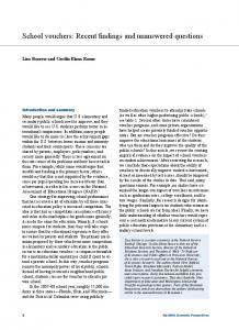
140
and the staves, have changed since. Figure 2 shows the distribution of the different
141
levelling classes in the ANLN; two additional classes can be seen that are not referred to
142
in Table 1 or by ICSM (2004).
143
These are i) one-way third-order, which is levelling to the third-order standard,
144
but only levelled one way, and ii) two-way levelling (Steed, 2006, unpub. rep.), the
145
specifications and quality of which appear undefined. For this study, the one-way third-
146
order and two-way levelling were both assigned a permissible c-value of 12, in line with
Australian Journal of Earth Sciences (submitted)
7
147
the third-order specifications; this is considered appropriate until a better empirical
148
estimate can be obtained.
149 150
Table 2 near here
151 152
An analysis of the 1366 ANLN loop misclosures is shown in Table 2. The
153
computed c-values include rejected loops as it is considered that this appropriately
154
reflects the quality of each class of levelling in the AHD. Each loop was allocated an
155
order based on the lowest class of levelling for any of the sections that comprised that
156
loop (cf. Table 1). The average loop closure (or c-value) can be calculated using the
157
rejection criteria rearranged as c=r/√d, where r is the calculated misclosure of each loop
158
from the GA-supplied database. To arrive at an average c-value for each class, the
159
average of the loops in each particular class was taken. The average loop closure c for
160
the ANLN is 5.2 mm/√d, and compares well with the 6 mm/√d from Lambert and
161
Leppert (1976) for the ALS, which was used in the original AHD (Roelse et al., 1971,
162
1975).
163
From Table 2, the one-way third-order levelling (which comprises almost 19%
164
of the loops in the ANLN) contains many gross errors (over a quarter of them were
165
rejected at 12mm/√d). The magnitude of the loop closures from the one-way third-order
166
rejected loops should also be examined; if a rejection limit of 20 mm/√d were arbitrarily
167
adopted and considered a large misclosure (e.g., 0.45 m misclose for a 500 km loop
168
compared to 0.27 m for 12 mm/√d), 29 one-way third-order loops would still be rejected
169
compared to only one two-way third-order loop. This reflects the lack of checks that
Australian Journal of Earth Sciences (submitted)
8
170
would have come from using two-way levelling, and has allowed errors to propagate
171
into the AHD.
172
Figure 3 indicates that the computed c-values are not normally distributed and
173
support Morgan (1992) in his analysis of the 1975 rapid two-way first-order levelling
174
along the northeastern coast of Australia. It was found that the closure of the two-way
175
levelling was also not normally distributed with ibid. suggesting the Weibul and
176
triangular distributions best represents the 1975 data, which strongly resembles Figure
177
3.
178
distributed.
On the other hand, histograms of the spirit-levelling misclosures are normally
179 180
Figure 3 near here
181 182
The maximum loop misclosure found was 0.93 m for loop #826 on the Western
183
Australia – Northern Territory border. As the 1366 loop misclosures (as opposed to the
184
computed c-value) are represented by a normal distribution, the standard deviation of
185
them is ~0.14 m. The distribution of the largest misclosures tends to coincide with the
186
one-way levelling (cf. Figure 2); most problems were found in Queensland, Western
187
Australia and the Northern Territory.
188
These results (8.6% loop rejection rate) appear to be at odds with documentation
189
in Roelse et al. (1971, 1975), where only class-LC and better levelling data were used
190
(with some rare exceptions; see ibid. chapter 7.2), and the analysis in Morgan (1992),
191
who concluded – albeit from only the basic network – that the AHD is principally a
192
third-order vertical datum.
193
transcription errors in this GA-supplied database (particularly within the two-way
This indicates that there may be some data entry /
Australian Journal of Earth Sciences (submitted)
9
194
sections where most gross errors appear), but we are unable to confirm this at present
195
for the following reasons.
196
Data entry / transcription errors cannot be verified because this GA-supplied
197
database only includes the average of the accumulated height difference between the
198
forward and reverse spirit-levelling traverses for each section. That is, we only have
199
single levelled height differences, rather than forward and reverse (i.e., two-way)
200
accumulated measurements, which will have been observed originally in order to gauge
201
closure in different directions, as per normal geodetic practice (e.g., Vaníček et al.,
202
1980; ICSM, 2004). Only the average height difference of the two-way runs were ever
203
entered into the digital record from the hardcopy summary sheets; the task to re-enter
204
the two-way levelling would be very time consuming and expensive because it would
205
require manually inspecting the now-archived field books or summary sheets to extract
206
the required information.
207
As such, the current format of the GA-supplied database does not permit us to
208
use the forward and reverse levelling traverses to further cross-check this database,
209
which is quite a significant deficiency.
210
auxiliary height information to isolate the misclosures until the forward and reverse
211
levelled height differences are extracted from the original field-books or summaries,
212
which as pointed out, is a particularly large task for ~177,000 km of two-way levelling
213
in the basic and supplementary networks used in the AHD (Roelse et al., 1971, chapters
214
1.6 and 1.7).
This has necessitated the interim use of
215
For this study, auxiliary height differences (as pseudo-observations) were
216
derived from GPS and the AUSGeoid98 regional gravimetric quasigeoid model
217
(Featherstone et al., 2001).
The GPS-derived height differences come from a
Australian Journal of Earth Sciences (submitted)
10
218
reasonably recent 586-point dataset compiled from various datasets supplied by GA (cf.
219
Featherstone and Sproule, 2006; Soltanpour et al., 2006) or Landgate (WA government)
220
(L. Morgan, 2007, pers. comm.).
221
All of these 586 GPS stations have AHD heights provided by GA (Steed, 2006,
222
unpub. rep.), allowing a derived connection to ANLN junction points to be calculated
223
for our levelling-only dataset. This permits additional loops to be formed and add
224
redundancy to help isolate some of the problematic sections from the analysis of the
225
spirit-levelled loop closures only (cf. Table 2). However, this approach assumes that
226
the GPS-AUSGeoid98-derived height differences are more accurate than the
227
misclosures being sought and that the connections to the ANLN are correct.
228
Using these auxiliary GPS-AUSGeoid98-derived height differences, we were
229
able to form an additional 313 loops, but with 90 rejected at class-LC tolerance (in areas
230
of known problems; see above). Of these, five loops showed misclosures of greater
231
than 1 m (largest was 1.25 m, computed c = 46.9 mm/√d), and the standard deviation of
232
the misclosures for all 313 loops is ±0.30m. Although the misclosures for the 313 GPS-
233
AUSGeoid98-derived loops are larger than for the 1366 spirit-levelling loops (~±0.30m
234
STD versus ~±0.15m STD), the additional redundancy (an extra 23% of loops) is
235
indeed beneficial, as will be shown next. Also, the larger standard deviation simply
236
reflects our focus on the problematic spirit-levelling loops.
237 238
Case-study Examples
239 240
Figure 4 near here
241
Australian Journal of Earth Sciences (submitted)
11
242
Figure 4 shows the first application of this approach by using three additional closed
243
GPS-AUSGeoid98-derived height differences to isolate the spirit-levelled section that
244
causes a misclosure in ANLN supplementary loop #821 in Western Australia. From the
245
GA-supplied spirit-levelling database only, loop #821 exhibits a misclosure of 0.45 m
246
(13.1 mm/√d) over a loop perimeter of ~1,200 km, which is marginally larger than the
247
allowable class-LC tolerance of 0.42 m (ICSM, 2004). Using adjacent spirit-levelling
248
loops only, it was simply not possible to ascertain which section or sections cause this
249
misclosure.
250
However, when incorporating the GPS-AUSGeoid98-derived height differences
251
to form additional loops, two of the sections in loop #821 showed misclosures of 0.02 m
252
and 0.03 m, with the southern section (Figure 3) showing a misclosure of 0.41 m
253
between ANLN junction points (JPs) 165 and 167 (GPS points 6062 and 6172).
254
Therefore, this approach of using pseudo-observations from GPS-AUSGeoid98-derived
255
height differences has successfully isolated the problematic section, which can now be
256
investigated much more efficiently than investigating the whole loop.
257
It is of interest that almost half of loop #821 comprises one-way third-order
258
levelling (dotted sections 806-1857-802-1561-1665-793 in Figure 2), whereas it is the
259
two-way third-order levelling that actually contains the gross error, when checked with
260
the GPS-AUSGeoid98-derived height differences. Normally, this whole loop would be
261
listed as a one-way third-order loop, as this is the lowest quality section contained in the
262
loop. However, it is not the one-way sections at fault (compensating errors of similar
263
magnitude in the one-way sections notwithstanding). This suggests that the 0.41 m
264
error (presumably) within one of the three two-way third-order sections (total ~210 km,
265
computed c = 28.3) is a gross error resulting from incorrect data entry. The logic
Australian Journal of Earth Sciences (submitted)
12
266
behind this conclusion is that if these sections were all levelled both ways and the
267
closure was checked between each benchmark (every 6-8 km along these sections), an
268
error of this magnitude should have been discovered.
269
However, as stated earlier, the GA-supplied database is not yet in a format to be
270
able to isolate this. Nevertheless, the power of using GPS-AUSGeoid98-derived height
271
differences remains, in that the problematic sections can be isolated for further
272
investigation, rather than re-examining the whole loop, presumably with [incorrect]
273
emphasis on the one-way third-order levelling sections in this case.
274 275
Figure 5 near here
276 277
Figure 5 gives another example where this approach is used in Queensland, near
278
the Northern Territory border, with only two GPS stations available for supplementary
279
loop #951. This spirit-levelling loop gave a misclosure of -0.46 m over a perimeter of
280
~709 km (computed c = 17.2) versus an allowable class-LC tolerance of 0.32 m. Two
281
new closed loops were formed with the GPS-derived height differences, one starting at
282
GPS station 6158, clockwise through the southern JPs of the levelled loop to GPS
283
station 6146.
284
corresponding loop from GPS station 6146 to 6158, following the northern side is -0.03
285
m. This illustrates that there is a gross error located in one of the southern sections of
286
loop #951 between JPs 588 and 1205.
This new southern loop gave a misclosure of -0.43 m, while the
287
More observations would be needed to confirm which section, but the search
288
space is now reduced, as opposed to having to check the entire loop. However, the
289
‘prime suspect’ in these particular sections (notwithstanding the earlier observation in
Australian Journal of Earth Sciences (submitted)
13
290
Western Australia) is the section of one-way third-order levelling between JPs 598 and
291
1244. It would be logical to suggest from these examples that gross errors in one-way
292
levelling are more likely to be observational or field-booking errors, while gross errors
293
found in two-way sections are more likely to be data entry / transcription errors made
294
after the section height differences had been averaged, so no check could be made.
295
Again, this reinforces the need for a concerted effort to isolate the source(s) of errors in
296
the ANLN and AHD.
297 298
DISCUSSION AND ISSUES ARISING
299
This closure-based investigation has revealed a principal restriction with the GA-
300
supplied ANLN levelling database, where only the average of the accumulated height
301
differences between JPs of the basic and supplementary levelling is given, rather than
302
the height differences as observed in each direction. This would have added more than
303
twice as much redundancy to help isolate the erroneous levelling sections, even from the
304
spirit-levelling data alone, and without the need to include pseudo-observations from
305
GPS and AUSGeoid98. It is simply a case of being able to utilise any additional
306
redundancy as best as possible because levelling observations are underdetermined.
307
For instance, combinations and permutations of forward and reverse height
308
differences could be used to isolate problem sections and check for data-entry /
309
transcription errors with much more confidence than is currently possible with the GA-
310
suppled dataset. However, in the meantime, this study has shown that GPS baselines, in
311
conjunction with a precise regional quasigeoid model, where available as pseudo-
312
observations, can be used to isolate erroneous levelling sections provided that the
Australian Journal of Earth Sciences (submitted)
14
313
combined precision of the GPS-geoid-derived height differences is less than the
314
magnitude of the misclosure being sought, which appears to be the case so far.
315
Aside from the above issue of the unavailability of two-way levelling height
316
differences where they were observed, if this GA-supplied database is to be used to try
317
to establish any new Australian vertical geodetic datum, some other issues arise, as
318
follows.
319 320
Datum Constraints
321
The ~1.5m north-south tilt in the AHD is now strongly suspected to come mostly from
322
fixing zero height for mean sea-level at multiple tide-gauges (e.g., Featherstone, 2004,
323
2006). If this artificial slope in Australian heights is to be avoided, three approaches
324
could be trialled in any new Australian vertical datum:
325
1) A sea-surface topography model can be used and constraints (rather than fixing) can
326
be applied to account for the error in these models, which are larger in the coastal zone
327
(e.g., Tapley et al., 2003);
328
2) A single tide-gauge can be fixed to zero height, which is consistent with widespread
329
practice in other countries (e.g. Vanicek et al., 1980), but the tide gauge must be located
330
to properly sample mean sea-level (cf. Featherstone and Kuhn, 2006), as well as not to
331
provide too many negative heights that could confuse lay users.
332
3) Alternatively, a tide-gauge need not be used, and another arbitrary height value
333
chosen not at a tide gauge (e.g., this height could be incremented arbitrarily so as to
334
avoid negative heights, thus avoiding confusion to lay users).
335 336
Australian Journal of Earth Sciences (submitted)
15
337
Choice of Height System
338
The AHD uses a truncated approximation of the normal-orthometric height system
339
(Roelse et al., 1971, 1975; Holloway, 1988; Featherstone and Kuhn, 2006) in which
340
heights will not close; the holonomity problem (cf. Sansò and Vaníček, 2006), nor will
341
fluids flow as expected.
342
proposed (Table 3), all but two require gravity observations at the benchmarks along the
343
levelling lines.
Although numerous different height systems have been
344 345
Table 3 near here
346 347
However, a cursory inspection of the ~1.2 million gravity observations in GA’s
348
May 2008 release of the national gravity database shows that only a few tens of
349
thousands of them have been observed at AHD benchmarks. Therefore, if opting for an
350
orthometric-type height system that is more holonomic and better describes fluid flow,
351
the lack of gravity observations at benchmarks along the levelling traverses will hamper
352
their proper implementation in Australia.
353
As an alternative to observing gravity along all AHD levelling lines, which
354
would be a massive task, the existing gravity observations in the GA national gravity
355
database could be interpolated to give predicted gravity at the 3D locations of the
356
benchmarks.
357
benchmarks are poorly known, typically to ~1.6 km as the ANLN database contains
358
latitude and longitude that was usually scaled (to the nearest minute of arc) manually
359
from 1:250,000 map sheets (Roelse et al., 1971, 1975). This is likely to hamper reliable
360
prediction, which in turn will affect the computation of the orthometric or normal
However, a problem arises in that the horizontal locations of the
Australian Journal of Earth Sciences (submitted)
16
361
corrections to the spirit-levelling. Nevertheless, since the orthometric correction is
362
more sensitive to height than gravity (e.g., Kao et al., 2000; Allister and Featherstone,
363
2001), this may not prove to be a large problem, but it must be tested.
364 365
Time Variations of Height and Gravity
366
While Australia is widely acknowledged to be a ‘geologically stable’ continent, changes
367
in height and gravity change can occur (cf. Biró, 1983). For instance, groundwater or
368
hydrocarbon extraction (e.g., van Gelderen et al., 1999) or other human development
369
(e.g., Belperio, 1993) and intraplate tectonics (e.g., Wellman and Tracey, 1987) can
370
cause land subsidence or uplift.
371
Therefore, an assumption will have to be made that the spirit-levelling
372
observations in the GA-supplied database are time-invariant, unless reliable vertical
373
motion models can be applied. However, the rates of vertical motion are likely to be
374
small in comparison to the ICSM (2004) class-LC levelling tolerance and the
375
misclosures found in the GA-supplied ANLN database (shown earlier).
376 377
Refraction and Tides
378
Another deficiency in the GA-supplied levelling database is that the date and time of the
379
observations and meteorological observations are not available, which prevents a full
380
analysis of atmospheric refraction and Earth tide corrections. Instead, simulations will
381
have to be run so as to determine whether they are likely to be significant in relation to
382
the class-LC tolerance. If they are, then a very time consuming and difficult task would
383
be needed to extract this information from the original field-books or summaries for
384
more than 177,000 km (as well as post-1971 observations) of two-way levelling.
Australian Journal of Earth Sciences (submitted)
17
385
However, it is also possible that this information was not even recorded at the time of
386
the surveys and matching field books to specific sections in the ANLN database could
387
also be difficult (G.Luton, 2007, pers. comm.).
388 389
New Spirit-levelling Data
390
New sprit-levelling carried out by State/Territory geodetic authorities since the
391
realisation of the AHD in 1971 has in some cases not been incorporated in the current
392
GA-supplied database, which is a restriction when searching for gross errors. For
393
instance, a visit by the first-named author to inspect South Australian levelling records
394
revealed additional levelling data (in hardcopy format) in the settled (southern) areas of
395
South Australia that would create numerous new loops within most existing ANLN
396
loops in this area. This is a large amount of redundancy that could be added to the
397
national network if it were made available in digital format for easy incorporation into
398
the ANLN database.
399
It was also found that a gross error identified by this study in a loop on the Eyre
400
Peninsula had already been identified and corrected by the South Australian geodetic
401
authorities, but the corrected or new observations were not forwarded to GA-for
402
inclusion in the national database. Western Australia (Landgate) has supplied most of
403
their new levelling in a suitable format (G. Holloway, 2007, pers. comm.), but it is
404
unknown whether this situation exists in other States/Territories. It would be essential
405
for such data be properly incorporated into the GA-supplied database before any new
406
vertical datum for Australia is attempted.
407 408
Australian Journal of Earth Sciences (submitted)
18
409 410
SUMMARY, CONCLUSION AND RECOMMENDATION
411
We have shown that GPS and a gravimetric quasigeoid model can be used as pseudo-
412
observations to isolate spirit-levelling errors in low-order vertical geodetic datums when
413
additional information (e.g., forward and reverse accumulated height differences) is not
414
available, as is the case with the current GA-supplied levelling database for the AHD.
415
The success of the technique rests on the assumption that the GPS-quasigeoid-
416
derived height differences are more precise than the magnitude of the spirit-levelling
417
misclosure being sought, but this is proven to be the case in the two case-study
418
examples where GPS-AUSGeoid98-derived height differences do indeed isolate the
419
problematic sections. This eases the task of locating the errors, where effort can be
420
focussed on the problematic section, rather than having to re-examine the entire loop.
421
We have also discussed some related issues should this database be used to attempt to
422
establish a new Australian vertical datum in the future,
423
While the definition and realisation of the AHD may appear to be a geodetic-
424
only issue, it has ramifications for all Earth-science-related studies in Australia. For
425
instance, errors in the current AHD will contaminate DEMs derived from data tied to
426
this datum, which is normally the case. Therefore, Earth-science-related studies in
427
Australia that rely on DEMs, or other height-related data, will be affected by
428
deficiencies in the existing AHD.
429
community that the height data that they use appear to be based on a somewhat deficient
430
vertical datum.
As such, we aim to remind the Earth science
431 432
Australian Journal of Earth Sciences (submitted)
19
433 434
ACKNOWLEDGEMENTS
435
Firstly, we would like to thank Gary Johnston, Geoff Luton and Jim Steed (ret.) of Geoscience
436
Australia for providing the ANLN and GPS data and Linda Morgan and Graeme Holloway of
437
Landgate for providing the WA GPS data. MSF thanks Curtin University of Technology for an
438
Australian Postgraduate Award and Land Services Group (SA) for assistance during his visit to
439
Netley in February 2008. WEF thanks the Australian Research Council for an Australian
440
Professorial Fellowship through grant DP0663020. We would also like to thank the reviewers
441
and editors for their comments on this manuscript.
442
Research (TIGeR) publication number XX.
This is The Institute for Geoscience
443 444
REFERENCES
445
ALLISTER N.A. & FEATHERSTONE W.E. 2001. Estimation of Helmert orthometric heights using
446
digital barcode levelling, observed gravity and topographic mass-density data over part of the
447
Darling Scarp, Western Australia, Geomatics Research Australasia, 75, 25-52.
448
ANGUS-LEPPAN P.V. 1975. An investigation of possible systematic errors in levelling along the
449
eastern coast of Australia, UNISURV Report G-23, School of Surveying, University of New
450
South Wales, Sydney, 80-91.
451
BELPERIO A.P. 1993. Land subsidence and sea level rise in the Port Adelaide estuary: Implications
452
for monitoring the greenhouse effect, Australian Journal of Earth Sciences, 40, 359-368, doi:
453
10.1080/08120099308728087
454
BIRÓ P. 1983. Time Variation of Height and Gravity, Wichmann, Karlsruhe.
455
CARROLL D. & MORSE M. P. 1996. A national digital elevation model for resource and
456
environmental management. Cartography 25, 395–405
457
COLEMAN R., RIZOS C., MASTERS E.G. & HIRSCH B. 1979. The investigation of the sea-
458
surface slope along the north-eastern coast of Australia, Australian Journal of Geodesy,
459
Photogrammetry and Surveying, 31, 65-99.
Australian Journal of Earth Sciences (submitted)
20
460
DENNIS M.L. & FEATHERSTONE W.E. 2003. Evaluation of orthometric and related height
461
systems using a simulated mountain gravity field, In: Tziavos, I.N. ed. Gravity and Geoid 2002,
462
pp. 389-394. Department of Surveying and Geodesy, Aristotle University of Thessaloniki.
463 464
DENTITH M.C. & FEATHERSTONE W.E. 2003. Controls on intra-plate seismicity in southwestern Australia, Tectonophysics 376, 167-184, doi: 10.1016/j.tecto.2003.10.002.
465
FEATHERSTONE W.E. 1998. Do we need a gravimetric geoid or a model of the base of the
466
Australian Height Datum to transform GPS heights? The Australian Surveyor, 43, 273-280.
467
FEATHERSTONE W.E. 2000. Towards unification of the Australian height datum between the
468
Australian mainland and Tasmania using GPS and the AUSGeoid98 geoid model, Geomatics
469
Research Australasia, 73, 33-54.
470
FEATHERSTONE W.E. 2001. Prospects for the Australian Height Datum and geoid model, In:
471
Adam, J. and Schwarz, K-P. eds. Vistas for Geodesy in the New Millennium, pp. 96-101,
472
Springer, Berlin Heidelberg New York.
473 474 475 476
FEATHERSTONE W.E. 2004. Evidence of a north-south trend between AUSGeoid98 and the AHD in southwest Australia, Survey Review, 37, 334-343. FEATHERSTONE W.E. 2006. Yet more evidence for a north-south slope in the AHD, Journal of Spatial Science, 51, 1-6. Corrigendum in 52, 65-68.
477
FEATHERSTONE W.E. & FILMER M.S. 2008. A new GPS-based evaluation of distortions in the
478
Australian Height Datum in Western Australia, Journal of the Royal Society of Western
479
Australia, 91(2).
480 481
FEATHERSTONE W.E. & KUHN M. 2006. Height systems and vertical datums: a review in the Australian context, Journal of Spatial Science, 51, 21-42.
482
FEATHERSTONE W.E. & SPROULE D.M. 2006. Fitting AUSGeoid98 to the Australian Height
483
Datum using GPS data and least squares collocation: application of a cross-validation technique,
484
Survey Review, 38, 573-582.
485
FEATHERSTONE W.E. & STEWART M.P. 1998. Possible evidence for systematic distortions in
486
the Australian Height Datum in Western Australia, Geomatics Research Australasia, 69, 1-14
Australian Journal of Earth Sciences (submitted)
21
487
FEATHERSTONE W.E., KIRBY JF., KEARSLEY A.H.W., GILLILAND J.R., JOHNSTON G.M.,
488
STEED J., FORSBERG R. & SIDERIS M.G. 2001. The AUSGeoid98 geoid model of Australia:
489
data treatment, computations and comparisons with GPS-levelling data, Journal of Geodesy, 75,
490
313-330, doi: 10.1007/s001900100177.
491
GILLILAND J.R. 1986. Heights and GPS, The Australian Surveyor, 33, 277-283.
492
HAMON B.V. & GREIG M.A. 1972. Mean sea level in relation to geodetic land levelling around
493 494 495
Australia, Journal of Geophysical Research, 77, 7157-7162. HECK B. 1995. Rechenverfahren und Auswertemodelle der Landesvermessung, Wichman, Karlsruhe.
496
HEISKANEN W.A. & MORITZ H. 1967. Physical Geodesy, Freeman, San Francisco.
497
HELMERT F.R. 1884. Die Mathematischen und Physikalischen Theorien der Höheren Geodäsie,
498 499 500
Teubner, Leipzig, Germany, (re-printed by Minerva, Frankfurt, Germany, 1962). HELMERT F.R. 1890. Die Schwerkraft im Hochgebirge, Insbesondere in den Tyroler Alpen. Veroff. Konigl. Preuss., Geod. Inst., No. 1.
501
HILTON R.D., FEATHERSTONE W.E., BERRY P.A.M., JOHNSTON C.P.D. & KIRBY J.F.
502
2003. Comparison of digital elevation models over Australia and external validation using ERS-
503
1 satellite radar altimetry, Australian Journal of Earth Sciences, 50, 157-168, doi:
504
10.1046/j.1440-0952.2003.00982.x
505
HOLLOWAY R.D. 1988. The integration of GPS heights into the Australian Height Datum,
506
UNISURV Report S33, School of Surveying, The University of New South Wales, Sydney, 151 .
507
HUTCHINSON M.F. & DOWLING T.I. 1991. A continental hydrological assessment of a new
508
grid-based digital elevation model of Australia. Hydrological Processes, 5, 45-58.
509
ICSM 2002. Geocentric Datum of Australia Technical Manual, Version 2.2, Inter-governmental
510
Committee on Surveying and Mapping, http://www.icsm.gov.au/icsm/gda/gdatm/index.html
511
ICSM 2004. Standards and Practices for Control Surveys (SP1, version 1.6), Inter-Governmental
512
Committee on Surveying and Mapping, http://www.icsm.gov.au/publications/sp1/sp1v1-6.pdf
Australian Journal of Earth Sciences (submitted)
22
513
JAIN V., PRESTON N., FRYIRS K. & BRIERLEY G. 2006. Comparative assessment of three
514
approaches for deriving stream power plots along long profiles in the upper Hunter River
515
catchment, New South Wales, Australia. Geomorphology, 74, 297-317.
516
JOHNSTON G.M. & LUTON G.C. 2001. GPS and the Australian Height Datum, In: Kubik, K.,
517
Rizos, C. and Featherstone, W.E. eds. Proceedings of the Fifth International Symposium on
518
Satellite Navigation Technology and Applications, Canberra, July, [CD-ROM].
519 520 521 522 523
KAO S-P., RONGSHIN H. & NING F-S. 2000. Results of field test for computing orthometric correction based on measured gravity, Geomatics Research Australasia, 72, 43-60. KEARSLEY A.H.W., RUSH G.J. & O’DONELL P.W. 1988. The Australian Height Datum problems and proposals, The Australian Surveyor, 34, 363-380.
KEARSLEY A.H.W., AHMED Z. & CHAN A. 1993. National height datums, levelling, GPS
524
heights and geoids, Australian Journal of Geodesy Photogrammetry and Surveying, 59, 53-
525
88.
526
KIRBY J.F. & FEATHERSTONE W.E. 1999. Terrain correcting Australian gravity observations
527
using the national digital elevation model and the fast Fourier transform, Australian Journal of
528
Earth Sciences, 46, 555-562. doi: 10.1046/j.1440-0952.1999.00731.x.
529
KIRBY J.F. & FEATHERSTONE W.E. 2002. High-resolution grids of gravimetric terrain
530
correction and complete Bouguer corrections over Australia, Exploration Geophysics, 33, 161-
531
165.
532 533
KUHN M., FEATHERSTONE W.E. & KIRBY J.F. 2008. Complete spherical Bouguer gravity anomalies over Australia. Australian Journal of Earth Sciences, in press.
534
LAMBERT B.P. & LEPPERT K. 1976. A study of the Australian national levelling survey, In:
535
Report of proceedings of the Conference of Commonwealth Survey Officers, Cambridge, August
536
1975, paper no. C5. HMSO, London.
537
LEPPERT K. 1967. Problems encountered in the use of third order levelling for the national
538
levelling grid, In: Angus-Leppan, P.V. ed. Control for Mapping by Geodetic and
539
Photogrammetric Methods, pp. 123-134. The University of New South Wales, Sydney.
Australian Journal of Earth Sciences (submitted)
23
540
LEPPERT K., HAMON B.V. & MATHER R.S. 1975. A status report on investigations of sea
541
surface slope along the eastern coast of Australia, UNISURV Report G-23, School of Surveying,
542
University of New South Wales, Sydney, 60-67.
543 544
LINES J.D. 1992. Australia on Paper - The Story of Australian Mapping, Fortune Publications, Box Hill.
545
LUDWIG J.A., BASTIN G.N., CHEWINGS V.H., EAGER R.W. & LIEDLOFF A.C. 2007.
546
Leakiness: A new index for monitoring the health of arid and semiarid landscapes using
547
remotely sensed vegetation cover and elevation data. Ecological Indicators, 7, 442-454.
548
MACLEOD R.T., KEARSLEY A.H.W. & RIZOS C. 1988. GPS surveys of mean sea-level along
549
the New South Wales coastline, Australian Journal of Geodesy, Photogrammetry and
550
Surveying, 49, 39-53.
551
MADER K. 1954. Die orthometrische Schwerekorrektion des Präzisions-Nivellements in den Hohen
552
Tauern (The orthometric weight correction of precision levelling in high terrain),
553
Österreichische Zeitschrift für Vermessungswesen, Sonderheft 15, Vienna.
554 555 556 557
MITCHELL H.L. 1973a. An Australian geopotential network based on observed gravity, UNISURV Report G18, School of Surveying, University of New South Wales, Sydney, 80. MITCHELL H.L. 1973b. Relations between mean sea level and geodetic levelling in Australia, UNISURV Report S9, School of Surveying, University of New South Wales, Sydney, 277.
558
MITCHELL H.L. 1973c. Sea-surface topography in geodesy with particular reference to Australia,
559
Proceedings of the Symposium on the Earth's Gravitational Field and Secular Variations in
560
Position, The University of New South Wales, Sydney, Australia.
561 562 563 564
MITCHELL H.L. 1988. GPS heighting in Australia: an introduction, The Australian Surveyor, 34, 510. MITCHELL H.L. ed. 1990. Heighting with the Global Positioning System in Australia: the current situation. Report of the GPS Heighting Study Group of the Australian GPS Users Group.
565
MOLODENSKY M., YEREMEYEV V. & YURKINA, M. 1962. Methods for Study of the
566
External Gravitational field and Figure of the Earth, Israeli Program for Scientific
567
Translations, Jerusalem.
Australian Journal of Earth Sciences (submitted)
24
568 569 570 571 572 573 574 575
MORGAN P.J. 1992. An analysis of the Australian Height Datum: 1971, The Australian Surveyor, 37, 46-63. NIETHAMMER T. 1932. Nivellement und Schwere als Mittel zur Berechnung wahrer Meereshöhen, Schweizerische Geodätische Kommission, Berne, Switzerland. NMC 1986. Australian Geodetic Datum Technical Manual, Special Publication 10, National Mapping Council, Canberra. RAPP R.H. 1961. The orthometric height, M.S. Thesis, Department of Geodetic Science, The Ohio State University, Columbus.
576
REINFELDS I., COHEN T., BATTEN P. & BRIERLEY G. 2004. Assessment of downstream
577
trends in channel gradient, total and specific stream power: a GIS approach. Geomorphology,
578
60, 403-416.
579
RIZOS C., COLEMAN R. & ANANGA N. 1991. The Bass Strait GPS survey: preliminary results
580
of an experiment to connect Australian height datums, Australian Journal of Geodesy,
581
Photogrammetry and Surveying, 55, 1-25.
582
ROELSE A., GRANGER H.W. & GRAHAM J.W. 1971. The adjustment of the Australian levelling
583
survey 1970 – 1971, (1st edition), Technical Report 12, Division of National Mapping, Canberra,
584
Australia.
585
ROELSE A., GRANGER H.W. & GRAHAM J.W. 1975. The adjustment of the Australian levelling
586
survey 1970 – 1971, (2nd edition), Technical Report 12, Division of National Mapping,
587
Canberra, Australia.
588 589
SANSÒ F. & VANÍČEK P. 2006. The orthometric height and the holonomity problem, Journal of Geodes , 80, 225-232, doi: 10.1007/s00190-005-0015-7.
590
SANTOS M.C., VANÍČEK P., FEATHERSTONE W.E., KINGDON R., ELLMANN A., MARTIN
591
B.A., KUHN M. & TENZER R. 2006. The relation between the rigorous and Helmert’s
592
definitions of orthometric heights, Journal of Geodesy, 80, 691-704, doi: 10.1007/s00190-006-
593
0086-0.
Australian Journal of Earth Sciences (submitted)
25
594
SOLTANPOUR A., NAHAVANDCHI H. & FEATHERSTONE W.E. 2006. The use of second-
595
generation wavelets to combine a gravimetric geoid model with GPS-levelling data, Journal of
596
Geodesy, 80, 82-93, doi: 10.1007/s00190-006-0033-0.
597 598
STEED J. 2006. Height modernisation project – data cleaning and adjustment, unpublished report, Geoscience Australia, Canberra.
599
TAPLEY B.D., CHAMBERS D.P., BETTADPUR S. & RIES, J.C. 2003. Large-scale ocean
600
circulation from the GRACE GGM01 geoid, Geophysical Research Letters, 30, 222163, doi:
601
10.1029/2003GL018622.
602
TENZER R., VANÍČEK P., SANTOS M., FEATHERSTONE W.E. & KUHN M. 2005. Rigorous
603
determination of the orthometric height, Journal of Geodesy, 79, 82-92, doi: 10.1007/s00190-
604
005-0445-2.
605 606 607 608
VAN GELDEREN M., HAAGMANS R.H.N. & BILKER M. 1999. Gravity changes and natural gas extraction in Groningen, Geophysical Prospecting, 47, 979-993. VANÍČEK P., CASTLE R.O. & BALAZS E.I. 1980. Geodetic leveling and its applications, Reviews of Geophysics and Space Physics, 18, 505-524
609
VERSTRAETEN G., PROSSER I.P. & FOGARTY P. 2007. Predicting the spatial patterns of
610
hillslope sediment delivery to river channels in the Murrumbidgee catchment, Australia.
611
Journal of Hydrology, 334, 440-454, doi: 10.1016/j.jhydrol.2006.10.025
612 613
WALKER J., DOWLING T. & VEITCH S. 2006. An assessment of catchment condition in Australia. Ecological Indicators, 6, 205-214.
614
WELLMAN P. & TRACEY R. 1987. Southwest seismic zone of Western Australia: measurement of
615
vertical ground movements by repeat levelling and gravity measurements, BMR Journal of
616
Australian Geology and Geophysics, 10, 225-232.
Australian Journal of Earth Sciences (submitted)
26
617
CLASS ORDER c (1σ) LA L1 4 LB L2 8 LC L3 12 LD L4 18 618 619
Table 1: Values for c relating to class and order from ICSM (2004). Class L2A and LE
620
have been omitted as they are not applicable to the ANLN.
621
LOOP TYPE ALL 1ST ORDER 2ND ORDER 3RD ORDER 4TH ORDER O-W 3RD ORD TWO-WAY O-W 3RD ORD & 4TH ORDER
NO. LOOPS 1366 56 20 975 37
% REJECTED REJECTED 117 8.6 8 14.3 1 5.0 30 3.1 1 2.7
ICSM (2004) C 4 8 12 18
COMPUTED C, including rejected loops 5.2 2.4 2.8 4.2 6.3
256 8
71 3
27.7 37.5
12 12
9.2 10.6
14
3
21.4
18
10.2
622 623
Table 2: Analysis of ANLN loops. Note that O-W is one-way, and loops containing
624
both one-way third-order and fourth-order levelling were evaluated separately from
625
their respective classes.
626 627 628 629 630 631
Australian Journal of Earth Sciences (submitted)
27
632
Height system
Gravity required
References
True orthometric
yes
Note that this height cannot be realised in practice because integral-mean gravity is required along the plumbline in the topography.
Helmert orthometric
yes
Helmert (1884, 1890), Rapp (1961), Heiskanen and Moritz (1967), Heck (1995), Allister and Featherstone (2001), Dennis and Featherstone (2003), Featherstone and Kuhn (2006)
Mader orthometric
yes
Mader (1954), Heck (1995), Dennis and Featherstone (2003), Featherstone and Kuhn (2006)
Neithammar orthometric
yes
Neithammar (1932), Heck (1995), Dennis and Featherstone (2003), Featherstone and Kuhn (2006)
Rigorous orthometric
yes
Tenzer et al. (2005), Santos et al. (2006)
Normal
yes
Molodensky et al. (1962), Heiskanen and Moritz (1967), Heck (1995), Dennis and Featherstone (2003), Featherstone and Kuhn (2006)
Normal-orthometric
no
Rapp (1961), Heck (1995), Featherstone and Kuhn (2006)
Ellipsoidal
no
Any textbook on GPS
633 634
Table 3. The various height systems available and whether they require
635
surface gravity along the spirit-levelling traverses.
636
Australian Journal of Earth Sciences (submitted)
28
637 638
Figure 1: Basic spirit-levelling traverses of the Australian levelling survey (ALS) used
639
to establish the AHD in 1971(from NMC, 1986).
640
Australian Journal of Earth Sciences (submitted)
29
641 642
Figure 2: Basic and supplementary spirit-levelling traverses of the ANLN; the
643
supplementary levelling was adjusted onto the basic levelling (by the then National
644
Mapping Council in 1971, and subsequently by State/Territory geodetic authorities) so
645
as to propagate the vertical datum further to users. Sections in yellow represent first
646
order, light green is second order, thin purple is third, dark green is fourth order, red is
647
one-way third order and blue is two-way levelling (Steed, 2006; quality undefined).
Australian Journal of Earth Sciences (submitted)
30
250
200
count
150
100
50
or e
20
M
18
16
14
12
11
10
9
8
7
6
5
4
3
2
1
0
0
computed c (=r/(sqrt(d)))
648 649
Figure 3: Histogram of the computed c-value from the levelling loop misclosures for the ANLN
650
(1366 loops). Since this distribution is not normal/Gaussian, descriptive statistics cannot be
651
used to summarise these data.
Australian Journal of Earth Sciences (submitted)
31
652 653
Figure 4: ANLN supplementary loop #821. Spirit-levelling sections are solid lines.
654
GPS stations are triangles 6062, 6712 and 6172. ANLN supplementary JP numbers are
655
underlined with basic in bold. Dotted sections 806-1857-802-1561-1665-793 are one-
656
way third order sections, with the remaining loop #821 sections two-way third order.
657
Australian Journal of Earth Sciences (submitted)
32
658 659
Figure 5: ANLN supplementary loop #951. Spirit-levelled sections are solid lines. GPS
660
stations are triangles 6158 and 6146. ANLN supplementary JP numbers are underlined
661
with basic in bold. The solid straight line on the left (running through GPS station 6146)
662
is the Queensland - Northern Territory border. Section 1205 to 597 is a two-way section,
663
while 1244 to 598 is a one-way third order section. The remaining sections are third
664
order two-way.
665
Australian Journal of Earth Sciences (submitted)