Interoperable Access of Remote Sensing Data Through NWGISS Liping Di, Wenli Yang, Meixia Deng, and Donna Deng George Mason University Laboratory for Advanced Information Technologies and Standards (GMU/LAITS)
[email protected] Ken McDonald NASA Goddard Space Flight Center, Code 423 Greenbelt, MD 20771, USA
Introduction • Huge volumes of geosptial data have been collected by public and private sects. – NASA EOS currently collects more than two Terabytes of data per day. – NASA EOSDIS manages more than 1 Pb of data.
• On-line access of multiple-dimension geospatial data at the user’s well is one of the important objectives of many DIS developments.
The Problems • The geospatial research and applications require data from multiple sources provided by different data providers. • Currently most data providers provide data in archive forms. – Take long time to obtain the data – No or very few data services – The forms of data from different data providers or even same provider are incompatible.
• Users cannot get the data in the form they want for analysis and significant times are needed for processing the acquired data in ready-for-analysis form.
Interoperable personalized ondemand data access and services • Recognize that individual data users have their unique requirements to the data. – Interoperable means data users can obtain data from multiple sources and/or providers in the same form – Personalized will ensure data services will meet the individual users’ needs. – On-demand means that data products have to be created ondemand because you don’t know what the exact needs of data users.
• Provide data to users in the form that exactly matches user’s requirement in term of format, spatial and temporal coverage, projection, and resolution.
Services functions required for providing the basic IPOGDAS • Data service functions – Reformatting – Spatial/temporal/parameters coordinate-based subsetting – Resampling – Reprojection/georectification
• Execution of the combination of those functions based on users’ requirement to the data will create on-demand products that exactly match users’ needs.
OGC Web Coverage Service Specification
• OGC Web Coverage Service Specification defines the interfaces between web-based clients and servers for accessing on-line multi-dimensional geospatial data in an interoperable way. • WMT-II developed the first version of WCS (0.4). • DTD-based WCS 0.5 was the baseline version of WCS in OWS 1.1 • OWS-1.1 developed schema-based WCS 0.6 and 0.7.
WCS Server Function Requirements • Spatial/temporal/parameters subsetting – required, through BBOX and range dimensions.
• Resampling – Required, through resx and resy to specify.
• Reformatting – Optional. A server could provide multiple coverage encoding formats for client to choose.
• Reprojection – Optional. A sever could provide multiple coverage SRSs.
• Georectification for swath data – Optional. A server could do the georectification on-the-fly to serve swath data as georectified grid.
NASA EOS Data Environment • HDF-EOS is the standard data format for NASA EOSDIS. Huge amount of remote sensing data is being produced in this format. • Make HDF-EOS data easily accessible to GIS users will greatly increase the utilization of EOSDIS data. • There are three data models in HDF-EOS – Grid--Georectified raster data – Swath--potential georeferable raster data – Point-- point measurement
Providing IPOGDAS to EOSDIS Data through OGC WCS • Develop an HDF-EOS WCS server. – Support all required service functions – Support all optional service functions • Provides data in any one of the twelve HDF-EOS supported projections by on-the-fly reprojections. • Supports multiple coverage encoding formats (HDF-EOS, GeoTiFF, and NITFF). • Geo-rectify swath data on-the-fly.
– Work with all types of HDF-EOS data
• Develop a multi-protocol geoinformation client (MPGC) that includes WCS. – Provide all services that are optional in the specification so that it can provide IPOGDAS even with a minimum server. – Able to work with all OGC WCS compliant servers.
NASA HDF-EOS Web GIS Software Suite (NWGISS) • Both WCS server and MGC are components of NWGISS. • Currently NWGISS has following components: – – – – –
map server coverage server catalog server multiple protocol geoinformation client Toolbox
• More components will be added • Components are able to work independently and collaboratively.
OGC Interface Specifications Implemented in NWGISS • Web Mapping Specification – GetCapabilities – GetMap – GetFeatureInfo
• Web Coverage Specification – GetCapabilities – GetCoverage – DescribeCoverageType
• OGC Catalog Interoperability Specification – CIP/Z39.50 – Stateless
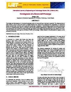
NWGISS Top Level Architecture OGC Compliant Clients (i.e. NWGISS MGC) OGC protocols
Integrated NWGISS OGC Server Interface Coverage
Mapping
Coverage server
Capabilities
Catalog
Catalog Server
Map server XML capability
catalog access
CreateCapabilities
HDF-EOS Files
Data Catalog
NWGISS Map Server • Enable GIS clients to access HDF-EOS data as maps. • Work with three OGC web mapping interface protocols – GetCapabilities • Tell the client about the server capabilities as well as map layers.
– GetMap • Extract the data from HDF-EOS file and convert it to a GIF map based on requirement specified by the client.
– GetFeatureInfo • Be able to tell the client geographic feature associate with
• Work with all three HDF-EOS data models – On-the-fly georectification and resampling for swath – On-the-fly resampling for grid – Geographic coordinate based data subsetting and map making for all three data models.
• Comply with OGC WMS 1.1.0 and lower.
NWGISS Coverage Server • Enable GIS clients to access multi-dimensional, multitemporal data in HDF-EOS. • Work with three OGC web coverage protocols – GetCapabilities • Tell the client about the server capabilities as well as data achieves.
– GetCoverage • Extract the data from HDF-EOS file based on spatial and temporal coordinates specified by the client and return the data back to client in one of the coverage encoding formats specified by the client. • Three coverage encoding formats, HDF-EOS, NITF, and GeoTIFF are defined in the specification.
– DescribeCoverageType
• Work with all three HDF-EOS data models – On-the-fly geo-rectification and re-sampling for swath. – On-the-fly data assembly and format conversion for all three data models.
• Comply with OGC WCS 0.5 and 0.6, working on 0.7
NWGISS Catalog Server • Enable GIS clients to search and find data, maps, and services available in a NWGISS site. • Compliant with OGC Catalog Interface Implementation Specification. – CIP/Z39.50 profile. – Stateless
NWGISS Multi-protocol Geoinformation Client (MPGC)
• Able to interactively communicate with all OGCcompliant coverage servers (not only NWGISS) for accessing multi-dimensional geospatial data. • Handle all three coverage encoding formats. • Providing reprojection, resampling, reformatting, subsetting and visualization of multi-dimensional geosptial data. • Able to work a map client, compliant with WMS 1.1.0 or lower. • Plan to include catalog and features access to the client.
NWGISS Toolbox • Provide automatic data ingestion and catalog creation for data providers to make their data ready for NWGISS. • At least two tools are available: – CreateCapabilities • Automatically create the XML-based capabilities description based on the NWGISS capabilities as well as data in HDF-EOS files. • It is a generic tool that can work with all HDF-EOS files.
– Two way translators between HDF-EOS and GIS formats. • Arc Grid, Binary, GeoTiff, Erdas lan.
Current Use of NWGISS • NWGISS is the only OGC-compliant map and coverage server in the world that serves HDF-EOS data directly to GIS clients. • CEOS WTF/GOFC • OGC WMT I, WMT II, OWS 1.1 & OWS 1.2. • NASA Data Pool project. • NASDA (Japan), ESA/ESRIN (EU), GISTDA (Thailand)
NWGISS Demo Site • Demo site for NWGISS map and coverage servers has been set up – Map server: http://laits.gmu.edu/cgibin/NWGISS?request=capabilities&service=WMS – Coverage server: http://laits.gmu.edu/cgibin/NWGISS?request=capabilities&service= WCS – MODIS level 1b, ASTR, AVRIS, TOMS ozone, etc. More data will be added.
• The map server can be accessed by map clients: – Cubewerx client. http://209.217.120.146/wmt/cubeview/cubeview.cgi – NASA Digital Earth Client: http://viewer.digitalearth.gov – Our one is called NASA-EOSDIS.
• Coverage access and services can be provided by NWGISS MPGC. A MPGC demo can show the access of both NWGISS and non-NWGISS coverage servers and map severs.