DEVELOPMENT OF IMAGE PROCESSING SYSTEM FOR ROCSAT-2 Frank Wu and An-Ming Wu
Ching-Jyh Shieh
National Space Program Office National Applied Research Laboratory Hsin-Chu, Taiwan, R.O.C.
[email protected] [email protected]
National Science Council Taipei, Taiwan, R.O.C.
[email protected]
ABSTRACT NSPO is developing a ROCSAT-2 Image Processing System (IPS), which aims to provide real-time high quality image data for ROCSAT-2 mission. The IPS is an integrated hardware and software system that provides full capabilities for the reception, archiving, cataloging, processing, and user query of the remotely sensed image data transmitted from the ROCSAT-2 Remote Sensing Instrument (RSI). The ROCSAT-2 will be launched in October 2003 and will be operated in circular sun-synchronous orbit of 891 km altitude with an inclination of 98.99 degree over a five-year mission lifetime. The descending nodal crossing time will be between 09:30 a.m. and 10:30 a.m. local time, and the revisit time will be one day. The RSI is an electrical –optical type of sensor with one panchromatic and four multi-spectral bands in visible and near infrared region. At nadir, the Ground sampling Distance (GSD) is 2m and 8m for panchromatic and multi-spectral bands, respectively. The nadir swath is 24km for all selected bands. The IPS system functions are grouped into four functional blocks: Data Ingestion Subsystem (DIS), Data Processing Subsystem (DPS), Planning and Scheduling Subsystem (PSS), and Data Management Subsystem (DMS). DIS is to perform frame synchronization, level 0 processing and moving window display. The DIS is capable of processing the input compressed and encrypted data with a rate of 120 Mbps or higher. DPS is for Level 1 to 4 data processing; Level 1 and 2 processing are for radiometric correction and geometric correction, respectively. And, Level 3-4 processing are geometric corrections with Ground Control Points (GCP) and Digital Elevation Model (DEM). PSS performs the planning and simulation for RSI activities, and generates mission timeline for the conflict-free planning and schedule activities for ROCSAT-2 satellite. DMS provides the functions for Image data archive and management, quick-look scene generation, station catalog generation and Graphic user interface. Except for DIS, the IPS is self-developed by NSPO with
the software engineering support from domestic software companies. The IPS development is starting from April 2001 and expected to be completed by August 2003. The system is currently under system integration and testing. In addition of extensive use of COTS software, a total of 95 K new Lines of Codes were developed. Because DIS is available from Commercial-off-self (COTS), the DIS is procured from EADS Systems & Defence Electronic Company (S&DE). In this paper, we will present the detailed implementation approaches and how we have achieved mission goals with a minimized cost through the self-development and extensive use of COTS products. 1.
INTRODUCTION
ROCSAT-2 is the second space program initiated by National Space Program Office (NSPO) of National Applied Research Laboratory at Taiwan. The primary goals of this mission are remote sensing applications for natural disaster evaluation, agriculture applications, urban planning, environmental monitoring, and ocean surveillance over Taiwan area and its surrounding oceans. The Image Processing System (IPS) is to provide full capabilities for the archiving, cataloging, and processing of the remotely sensed image data received from the ROCSAT-2 Remote Sensing Instrument (RSI). 2.
ROCSAT-2 Satellite Characteristics
ROCSAT-2 will pass over Taiwan two times a day. The satellite will be over Taiwan in the period of 9:30 to 10:30 am. The satellite will have 14 revolutions per day. The satellite has the viewing field of regard of 45-degree roll. The maximum imaging time over Taiwan contact will be roughly 8 minutes. The satellite is to be launched in October 2003. The ROCSAT-2 orbit will provide the capability of the daily revisit of the observed sites and could lead to outstanding products to monitor specific areas.
The RSI of ROCSAT-2 provides for 2m Ground Sampling Distance (GSD) in panchromatic band, and 8m GSD, in Multi-spectral (MS) band. The swath width is 24 km in the Nadir direction. It has five spectral bands from 450nm to 900 nm. Remote sensed data downlink data rate is 120 Mbps at X-band.
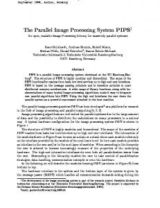
The IPS system is defined, designed and implemented to support the ROCSAT-2 mission. The IPS system functions are grouped into four functional blocks: DIS, DPS, PSS and DMS as shown in Fig.1. DIS is to perform frame synchronization, level 0 processing and moving window display. The DIS is capable of processing the input data with a rate of 120 Mbps or higher. DPS is for Level 1 to 4 data processing; Level 1 and 2 processing are for radiometric correction and geometric correction, respectively. And, Level 3-4 processing are geometric corrections with Ground Control Points (GCP) and Digital Elevation Model (DEM). PSS performs the planning and simulation for RSI activities, and generates mission timeline for the conflict-free planning and scheduling activities for ROCSAT-2 satellite. DMS provides the functions for Image data archive and management, quick-look scene generation, station catalog generation and Graphic user interface.
The key satellite characteristics are the following: Launch Vehicle: Taurus Mission Orbit: 891 km circular, sun synchronous Mission Life: 5 years minimum Spacecraft Reliability after 5 years: 0.6 Attitude Control: 3 Axis Stabilization Pointing Accuracy: 0.12 degree (1850m on ground) Pointing knowledge: 0.02 degree (315m on ground) Jitter: 0.15 PAN IFOV over 308 microsecond 3.
SYSTEM ARCHITECTURE AND DATA FLOW
IPS
Image Data Downlink Raw Data
L0 File
Data Ingestion Subsystem (DIS)
Tasking Request
Imaging Tasking Uplink
X-Band Receiving Station
L0 Data, Ephemeris, GCP and DEM
Planning & Scheduling Subsystem (PSS)
RSI Mission Time Line
Data Management Subsystem (DMS)
MMC
Calibration Para. Update
CWB
L1A, 2, 3, 4 Data
Data Processing Subsystem (DPS)
TT&C Station Imaging Tasking Load
Tasking Order, Product Order
GCP DEM
RSI Team
Catalog, Quick-look Scene, Image Products
GTS
USERS
Fig.1 IPS System architecture The interrelations among subsystems are shown in Fig 1. The tasking orders from users are collected and checked first by DMS and then past to PSS for tasking scheduling requests. The PSS will check the on-board resource and plan the optimized imaging activities, and then send a mission timelines to MMC for uplink to S/C. The MMC will re-check on-board resources and resolve conflicts, and send the confirmation to PSS through an Acquisition Report. The PSS will forward the Acquisition Report to DIS to prepare acquisition, and to DMS to report back to
users about tasking request status. Once the pass started, the XAS will transmit the demodulated and bit-sync data to DIS. DIS will record the received raw data to its on-line disk array and tapes. Immediately after the pass, the DIS will display the sub-sampled raw data on the Moving Windows, and meantime, decode and decompress the raw data and generate the level-0 data and inform DMS about the data availability. The level-0 data will then by retrieved by
DMS for archiving and further processing. The DMS will perform the level-1 processing for the received lecvel-0 data and generate the Quick-Look Scene (QLS) and update the image catalogs. The users will be able to browse the QLS images through the Internet interface and select the sets of image products that he/she
is interested. The user will issue the Product Orders to DMS for the selected image Products. If products are already in archive, DMS will retrieve from disk arrays or tape library and pass to users. In case the products not yet available in archive; the DMS will pass the product requests to DPS for processing the requested image products.
Users
Image Application and Distribution Center (Northern Region)
Image Application and Distribution Center (Central Region)
Image Application and Distribution Center (Southern Region)
Level 1A Level 1A
National Center University CSRSR
Level 1A
Level 1A
ROCSAT-2 IPS
X-Band Antenna
Level 2/3/4
National Environment Monitoring Agencies
X-Band Antenna
Fig 2. ROCSAT 2 Image Data Distribution
4.
IMPLEMENTATION APPROACHES
NSPO with a support from the ROC domestic company, Tatung System technologies Inc. (TSTI) performed most of the software development and testing for IPS. NSPO is responsible for all the instrument operations and algorithm related developments. Both PSS and DPS software are developed by NSPO. TSTI is responsible for the DMS development and IPS hardware integration and installation. The DIS are developed by S&DE. The total lines of codes developed for IPS are the followings: 50 K for DMS, 30K for DPS (Level 1 and 2 processing), 10 K for PSS and 5K for DIS. NSPO is responsible for all the system specification, system design and system Integration and testing. The IPS development life cycle includes the following phases: planning, system design, subsystem design, implementation and testing, operations development and algorithm validation, and system integration and testing. The IPS development is starting from April 2001 and will finish at August 2003 for all DMS, DIS, PSS and DPS
(Level 1 and 2 processing). A total of 10 engineers from NSPO and 11 engineers from TSTI are involved in the IPS development. An extensive reuse of the previous in-house developed algorithms and codes make possible for the system completed on schedule and is ready for the ROCSAT-2 image processing. 5.
IMAGE APPLICATIONS AND DISTRIBUTION
In addition to IPS, NSPO is also planning to establish a network of Image Application and Distribution Centers (IADC) around Taiwan to support the processing and distribution of ROCSAT-2 products (Fig. 2). The functions for IADCs will be the same as for IPS but without PSS and DIS. The IADCs will be capable to process and manage the Level 1 and 2 data and provide the data services to users. The benefits of these centers are the followings: Increase the efficiency of the overall ROCSAT-2 data processing: The distribution centers can get the level-0 data in a short time, usually a couple hours after acquisition, and will provide timely the
high-level processing and the applications and services for users.
value-added
Improving ROCSAT-2 data quality and its applications: By the involvement of a variety of technical groups around country, the technical applications of the ROCSAT-2 data can be maximized and the quality of services can be improved. Reduce the operational burden for NSPO: Because the IPS is self-developed, it is suitable for widely duplication and setup with a minimum cost. The distribution centers can share the burden the operational manpower required to process the large amount of daily ROCSAT-2 downlink data. 6.
DEVELOPMENT AND OPERATIONS COST REDUCTION
The cost reduction in IPS development, maintenance and operations is through the following approaches. To use standard hardware, COTS and the previous in-house developed software to reduce the development time and cost. To use engineers from NSPO and domestic company to implement new software, while the
contractor will provide technical assistance through reviews and working group sessions. This will reduce significantly the development cost and at mean times, ensure the quality of software. The infra structure and the technical experience gained from the ROCSAT-2 can be reused and reapplied for the future remote sensing missions. Not only the cost for the current development of IPS is reduced, the self-development will reduce the costs of new processing system for NSPO future missions 7.
CONCLUSIONS
The IPS have developed an integrated data processing and data management capability, which can provide real-time high quality image data for ROCSAT-2 mission. Except the front-end processor, the IPS is implemented by a joint team consisted of NSPO and a domestic software contractor. The system is capable to process the X-band compressed and encoded data with a rate of 120 Mbps or higher. The system is built up based on the standard hardware, COT products to reduce the maintenance and operations cost. The development cost is reduced through the extensive use of the resources from NSPO and domestic software engineers.