for conditional positioning performance, a low-complexity link selection mechanism ... core data fusion engine based on a conventional Extended. Kalman Filter ...
Distributed Link Selection and Data Fusion for Cooperative Positioning in GPS-aided IEEE 802.11p VANETs G.M. Hoang†‡ , B. Denis† , J. H¨arri‡ , D.T. Slock‡ Leti, MINATEC Campus, 17 rue des Martyrs, F38054 Grenoble, Cedex 9, France ‡ EURECOM, 450 route des Chappes, F06410 Biot Sophia Antipolis, France E-mails: {giaminh.hoang, benoit.denis}@cea.fr, {jerome.haerri, dirk.slock}@eurecom.fr
† CEA
Abstract—In future Intelligent Transport Systems (ITS), advanced car safety applications may require that each vehicle determines not only its own absolute position (i.e., “ego” car localization on the road) but also the positions of its immediate neighbors in a continuous and accurate way. For this sake, intervehicle data transmissions via Dedicated Short Range Communications (DSRC) (e.g., compliant with the IEEE 802.11p standard) can be exploited to support both peer-to-peer ranging based on Received Signal Strength Indicators (RSSI) and Cooperative Positioning (CP) between GPS-equipped vehicles. Since the aggregation of heterogeneous (and possibly asynchronous) sources of information remains quite challenging in such Vehicular Ad hoc NETworks (VANETs), we herein describe and compare gradually cooperative solutions that perform distributed data fusion through Extended Kalman Filtering (EKF). One first stake consists in re-aligning in time the data received from cooperating cars following a generalized prediction approach. In addition, using a so-called validation gate based on innovation monitoring and/or a Cram´er-Rao Lower Bound (CRLB) indicator accounting for conditional positioning performance, a low-complexity link selection mechanism is developed to identify the most relevant neighboring cars and/or the best RSSI candidates to feed the fusion engine. Preliminary simulation results, obtained under realistic IEEE 802.11p radio parameters and varying GPS accuracy conditions, illustrate benefits from selective cooperation, especially in terms of “ego” car navigation continuity. Index Terms—Car Navigation, Cooperative Positioning, Dedicated Short Range Communications, Global Positioning System, Hybrid Data Fusion, IEEE 802.11p, Link Selection, Local Dynamic Map, Received Signal Strength Indicator, Vehicular Ad Hoc Networks.
I. I NTRODUCTION For the last past years, Vehicular Ad hoc NETworks (VANETs), which typically rely on wireless inter-vehicle communications, have been attracting a worldwide attention for contributing to improved transportation efficiency. In the domain of car safety for instance, vehicles are supposed to get contextual information about events and/or other vehicles in their vicinity [1]. This type of information can be shared between the cars by exchanging specific beacons [1]–[4]. The IEEE 802.11p standard, which has been proposed to enable wireless access in this specific vehicle-to-vehicle (V2V) context [2], offers such Dedicated Short Range Communication (DSRC) means. Safety-related information (e.g., 2D
position from on-board GPS, speed, heading. . . ) are then encapsulated in Cooperative Awareness Messages (CAMs), which can be broadcasted over DSRC channels [1] and possibly used further for cooperative positioning (CP). Besides, due to the universal availability of satellites and large penetration into the mass market, the GPS technology has become de facto the standard solution for generic vehicular positioning [4]. However, its precision level and its accessibility still remain questionable in usual operating conditions (e.g., in urban canyons, under deep forest cover, in long tunnels, underground parkings. . . ). On the other hand, the practical range of accuracy affordable with typical GPS receivers (e.g., 3–10 m, even in favorable conditions) [2] may be insufficient in advanced safety applications (e.g., for longterm anti-collision systems anticipating on lane changes. . . ). With the development of the DRSC technology, CP in GPS-aided IEEE 802.11p VANETs thus discloses promising opportunities to improve “ego” car navigation capabilities in comparison with stand-alone satellite solutions (in terms of both average precision and robustness/continuity), but also to help cars to build and refine local dynamic maps (LDMs) accounting for their immediate vicinity. In this context, recent research initiatives have been focusing on hybrid data fusion techniques [5]. The idea is to optimally combine the position information delivered by on-board GPS receivers (shared among neighboring cars) with V2V range measurements relying on the Received Signal Strength Indicator (RSSI) of broadcasted CAMs [2], [4], [6], [7]. However, most contributions still make rather strong assumptions in terms of achievable radio coverage and connectivity (and hence, cooperation potential), V2V ranging performances (e.g., with constant standard deviation of range measurement noise, regardless of the true distance and/or channel conditions), and finally data synchronization among the different cars. In this paper, we propose a generic data fusion framework including i) a re-synchronization mechanism to properly incorporate cooperative information incoming from neighboring cars (i.e., location estimates and their related estimation covariances, encapsulated in the data payload of transmitted CAMs), ii) a link selection scheme to eliminate irrelevant or non-
c 2015 IEEE 978-1-4799-8923-2/15/$31.00
•
•
i θˆk|m is the estimate of θ ik at time step k based on past i time step m, k ≥ m (and similarly for x ˆik|m and v ˆk|m ); i Pk|m (·) is the covariance matrix of a particular variable i estimate such as θˆk|m , x ˆi . . . k|m
• •
Fig. 1. Approximately synchronous location estimates and asynchronous packets from neighboring vehicles 2 and 3 vs. local prediction timeline at vehicle 1.
informative cooperative information (i.e., V2V measurement outliers and/or non-reliable estimates from neighbors), iii) a core data fusion engine based on a conventional Extended Kalman Filter (EKF) enabling two correction modes (“ego” correction only or generalized correction including neighbors). Considering typical RSSI readings, one goal here is to verify if and to which extent V2V cooperation could be really beneficial. Evaluations are thus carried out through simulations, considering a Gauss-Markov mobility model, realistic IEEE 802.11p-compliant radio channel parameters (in terms of both path loss parameters and slow fading statistics), as well as varying GPS availability and precision levels over time. The remainder of the paper is organized as follows. In Section II, we introduce the CP problem in VANETs. Then Section III presents the proposed prediction-based data resynchronization, links selection and correction/fusion strategies. In Section IV, simulation results illustrate the achievable performance. Finally Section V concludes the paper. II. P ROBLEM S TATEMENT We first consider a network comprising N GPS-equipped vehicles distributed on a particular road segment, labeled 1, 2, . . . , N . The objective of each vehicle (later considered as “ego” vehicle) is to track its own 2D position, as well as the “constellation” formed by its immediate neighbors. In the scope of this work and in first approximation, it is assumed that the refresh rate of the location information is such that the position estimates locally available at the different cars are almost synchronous, as depicted in the example of Fig. 1 (with 3 vehicles only). This assumption is somehow justified by the possibility to extrapolate the results in the general asynchronous case (i.e., location estimates could be generated at distinct points in time but continuously and locally extrapolated on an arbitrarily finer time scale). To ease the notation, we also consider a global timeline divided into time windows indexed by k so that all the events occurring within this time slot granularity share the same index k. Throughout this paper, the following notations will be used: • •
t(·) is the global time of any event; � �T θ ik = xik , vki represents the state vector of vehicle i, including, for a two-dimensional (2D) system, its � �T � �T position xik = xik , yki and its velocity vki = x˙ ik , y˙ ki at time step k;
•
gki is the GPS observation expressed in a 2D Cartesian coordinate system for vehicle i at time step k; Pkj→i denotes the measured power (i.e., RSSI reading) of the beacon sent by vehicle j and received by vehicle i in the time interval [t(k − 1), t(k)). Nk→i gathers the indexes of the neighboring vehicles from which vehicle i can receive beacons/CAMs in the time interval [t(k − 1), t(k)).
Without loss of generality, we consider localizing the “ego” vehicle 1 at time step k. In the simplest non-cooperative scenario, the positioning algorithm just fuses the predicted 1 state θˆk|k−1 and the GPS estimate gk1 (treated as observation) 1 to provide a corrected state θˆk|k or alternatively, it can rely on 1
either θˆk|k−1 (i.e., loss of GPS signals) or gk1 (i.e., no available prediction). No location information is provided to the neighboring vehicles around. One step ahead, in half-cooperative schemes, each car broadcasts its latest position estimate in the next CAM so that its neighbors can directly incorporate the information in their own constellation representation (with no further processing). In full CP schemes, vehicle 1 at time step j k is still aware of the latest location estimates {θˆk−1|k−1 } produced by its neighbors j ∈ Nk→i , along with the corresponding covariance matrices, thanks to the received CAM notifications. However, such information is not utilized as is, since it is (by definition) out-of-date. Thus, a prediction step is required to re-synchronize all the estimates till any desired temporal point on the “ego” timeline (e.g., right at time step k in our case). Furthermore, the RSSI measurements derived from the received CAMs (i.e., the set {Pkj→1 }) are used as distancedependent observations together with the local GPS position estimate, so as to correct the predicted “ego” position and even possibly, the predicted positions of the neighboring cars (resulting in a larger state dimension and hence, higher filter complexity). In this paper, we only consider the first “ego” correction for simplicity. However, such RSSI measurements are not perfectly synchronized with each other (e.g., the CAM transmissions may occur at different rates and/or they can be event-driven). They are not either aligned in time with the moment when they are used for updating vehicle 1’s position estimate (i.e., at time step k). In case of highly correlated velocities (e.g., vehicles forming a group/platoon on a highway), relative distances remain quite stable in the medium term, and hence, so are expected the RSSI measurements (at least in average). Nevertheless, it is obviously not the case for vehicles traveling in opposite directions. For this reason, but also for the sake of discarding measurement outliers, while capturing only the most informative data from neighboring cars, one additional link selection step is highly recommended before performing fusion. In the VANET context, exhaustive cooperation in CP can also lead to degraded performance due
noises into account (e.g., in our case, including mismatches between the Gauss-Markov mobility model generating actual trajectories and the linear Gaussian state transition model assumed in the filter). Note that at a particular vehicle i, the matrices Fik and fki used to predict the “ego” position are supposed to be known. However, for its neighbors j ∈ Nk→i , i would need specific but a priori unknown mobility models (e.g., Fjk , fkj , and Qjk ). However, the later can still be determined empirically (e.g., out of observed past position estimates). Alternatively, they could be also included explicitly in the CAMs received from the neighbors. B. Measurements and Links Selection
Fig. 2. Overall fusion synopsis and data flow in GPS-aided IEEE 802.11p Cooperative Positioning (CP).
to the absence of known fixed anchors and accordingly, due to errors propagation among cooperating cars. Fig. 2 shows a block diagram of the overall fusion-based CP, recalling the main components. III. P ROPOSED A LGORITHMS A. Data Re-Synchronization As indicated previously, available sources of information (i.e., data received from neighbors and/or on-board devices like GPS) are adversely asynchronous in the high speed VANET context. To cope with this problem, data re-synchronization is then naturally achieved via an early prediction step applied to both “ego” and neighbors’ estimates (See Fig. 2). Even though various prediction schemes are feasible, spanning from simple (e.g., non-parametric prediction, Kalman prediction) to more sophisticated ones (e.g., parametric prediction, unscented transform with numerical integration (UT-NI)) [3], a very simple stochastic Kalman prediction is considered in this paper. It both fits the subsequent data fusion framework and lowers the impact of modeling errors by fine-tuning the magnitude of the process noise. Thus, in compliance with the scenario depicted in Fig. 1, the prediction step in Fig. 2 can be simply formulated as follows i i θˆk|k−1 = Fik θˆk−1|k−1 + fki ,
(1)
where Fik and fki are the system matrices of vehicle i at time step k, with a covariance matrix representing the fidelity of this prediction given by � �| Pik|k−1 (θ) = Fik Pik−1|k−1 (θ) Fik + Qik , (2) � � � | where Qik = E wki wki denotes the “need-to-tune” covariance matrix of process noise wki which takes unmodelled
So as to exclude uninformative incoming information that can ruin or alter the benefits of cooperation, a first validation gate (See Algorithm 1) is thus introduced to verify RSSIs by continuously monitoring normalized innovation terms. First of all, we perform a pre-processing step to discard non-reliable virtual anchors (i.e., badly positioned neighbors) by comparing the expected dispersion of their position estimates with that of the “ego” vehicle (i.e., based on covariance matrices), multiplied by an arbitrary scaling factor βth that can be set empirically. Accordingly, one “ego” vehicle i will not consider information from a cooperative neighbor j if � � � � trace Pjk|k−1 (x) > βth trace Pik|k−1 (x) . (3) Algorithm 1 Validation gate for link quality (iteration k, “ego” vehicle i, neighboring vehicle j) 1: procedure VALIDATION G ATE (k, i, j, xik|k−1 , Pik|k−1 (x), xjk|k−1 , Pjk|k−1 (x), Pkj→i , Rj→i , βth , γth ) k � � � � j 2: if trace Pk|k−1 (x) > βth trace Pik|k−1 (x) then . received information censoring 3: return remove ambiguity in link j 4: else (i,j) j→i 5: Pk|k−1 = h(xk|k−1 ) . predicted RSSI measurement j→i 6: ν j→i = Pkj→i − Pk|k−1 . innovation k 7: 8: 9: 10: 11: 12: 13: 14: 15:
(i,j)
Sj→i = Hk Pk|k−1 H| + Rj→i . innovation k k covariance matrix h i| qkj→i = ν j→i Sj→i ν j→i . normalized k k k innovation error if qkj→i < γth then . validation gate return select link j ∈ Vk→i , store qkj→i else return remove ambiguity in link j end if end if end procedure
After censoring neighbors’ estimates, a validation gate is executed to check the usability of the related RSSI measurements at the current time step k. The predicted RSSI measurement at vehicle i from vehicle j is thus computed according to a
classical log-distance path loss model [8], as follows � � (i,j) j→i Pk|k−1 = h xk|k−1
i j
xk|k−1 − xk|k−1 , = P0 (dBm) − 10np log10 d0
(4)
iT h (i,j) denotes the predicted where xk|k−1 = xik|k−1 , xjk|k−1 states of a pair of “ego” and neighboring vehicles (i, j), P0 (dBm) is the average received power at a reference distance d0 typically equal to 1 meter, np represents the path loss exponent and k·k stands for the Euclidean distance. Accordingly, we compute each innovation term as j→i , ν j→i = Pkj→i − Pk|k−1 k
(5)
with the associated covariance matrix (i,j)
Sj→i = Hk Pk|k−1 H| + Rj→i , (6) k k � � (i,j) where Pk|k−1 = diag Pik|k−1 (x), Pjk|k−1 (x) is the predicted covariance matrix of a pair formed� by “ego” � and (i,j) neighboring vehicles (i, j), H = (∂/∂x)h xk|k−1 is the Jacobian matrix of h (.) evaluated at the predicted point, and 2 Rj→i = σsh denotes the variance of the RSSI shadowing. k Assuming that the innovation term distributed, h is Normally i| j→i j→i S ν is χ2 the normalized innovation error ν j→i k k k distributed with nν degrees of freedom, where nν is the dimension of ν j→i . Therefore, the validation gate is defined k like in [9] as n h i| o j→i R(γth ) , Pk|k−1 : ν j→i Sj→i ν j→i ≤ γth (7) k k k where the detection threshold γth can be found from standard χ2 distribution tables to fulfill an a priori rate of false alarms. This gate specifies a region in measurement space for valid realizations (i.e., legitimate to feed the fusion engine), whereas the measurements outside the region are removed (for being outliers caused by noise and/or out-dated due to asynchronism). Up to this point, at time step k, we obtain for “ego” vehicle i the set of valid links for CP, denoted by Vk→i . But after re-synchronizing the data and validating candidate input measurements, additional links selection mechanisms can be applied to reduce errors propagation, computational complexity, energy consumption or over-the-air traffic (i.e., by censoring next Tx/Rx transactions). Related state-of-theart contributions in the field (e.g., [10], [11]) observed that the selected set could be rather limited (i.e., on the order of 3-4 links) with no significant performance degradation, while offering lower complexity. Therefore, in this work, we also set a priori the number of selected links to 3 (i.e., minimum number for non-ambiguous positioning in 2D). In a first proposal (See Algorithm 2), the innovation-based criterion consists in selecting the 3 links with the closest RSSI measurements from their predicted values (i.e., Nearest Neighbor (NN) criterion), whereas the second solution
(See Algorithm 3) takes into account a Cram´er-Rao Lower Bound (CRLB) characterizing the best achievable precision for non-biased location estimators (i.e., conditioned on a given set of neighbors). Note that the latter criterion captures both the Geometric Dilution Of Precision (GDOP) and the pairwise radio link quality. Accordingly, the Fisher Information Matrix (FIM) is approximated like in [8], [10] by � �� �| x ˆik|k−1 − x ˆik|k−1 − x ˆjk|k−1 x ˆjk|k−1 X ˆ Iik (s) =
4
i j∈{s,s1 ,s2 } ˆjk|k−1 xk|k−1 − x b ˆ h i−1 + Pik|k−1 (ˆ x) , (8) 2
where b = (σsh log(10)/ (10np )) , s1 and s2 refer to the 2 first selected links using the NN criterion whereas s denotes the third remaining free link used for CRLB comparisons (in Algorithm 3). Given s1 and s2 , each possible CRLB coni ditioned �h on ai new � s is simply computed as CRLBk (s) = −1 Iik (s) trace ˆ . The selection algorithm will then compare all the conditional CRLB results and determine as the third validated link the solution s ∈ Vk→i that minimizes the CRLB criterion, hopefully providing the best relative geometry into the CP problem resolution. Algorithm 2 NN-based link selection of 3 most informative links (iteration k, “ego” vehicle i, neighboring vehicles Vk→i ) 1: 2: 3:
procedure INK S ELECTION (Vk→i ) →i NNL if Vk > 3 then s1 = arg min qks→i s
4:
. second link
s3 = arg min qks→i
. third link
s2 = arg min s6=s1
5: 6: 7: 8: 9: 10:
. first link
qks→i
s6=s1 ,s2 return Sk→i =
{s1 , s2 , s3 } else return Sk→i = Vk→i end if end procedure
C. Final Fusion and Correction Conventional filters such as KF (or its linearized version EKF) [9] have been considered in the ultimate fusion block. When only the GPS position is used as observation (in noncooperative scenarios), we simply use the KF. If RSSI measurements are available, observations are non-linear functions of the estimated state variables so that EKF is preferred. IV. S IMULATION R ESULTS A. Simulation Settings and Scenarios In our evaluations, we consider a 3-lane highway model with 9 vehicles traveling in the same direction and separated by approximately 60 m (along the main moving direction) and by a typical lane width of 5 m (along the perpendicular direction). Their actual trajectories are simulated using the Gauss-Markov
Algorithm 3 Modified CRLB (MCRLB)-based link selection of 3 most informative links (iteration k, “ego” vehicle i, neighboring vehicles Vk→i ) procedure INK S ELECTION (Vk→i ) →i MCRLBL if Vk > 3 then 3: s1 = arg min qks→i . first link
1: 2:
s
4: 5: 6: 7: 8: 9: 10: 11: 12:
s2 = arg min qks→i
. second link
s6=s1 ∈ Vk→i \{s1 , s2 }
for s do s3 = arg min CRLBik (s)
. third link
s Sk→i
return = {s1 , s2 , s3 } end for else return Sk→i = Vk→i end if end procedure
mobility model for 100 seconds with a time step of 0.1 seconds (i.e., the minimum tolerated period between successive CAMs in IEEE 802.11p), assuming a memory level of 0.95, an asymptotic velocity standard deviation of 0.1 m/s, and an asymptotic mean velocity of 28 m/s. Concerning raw GPS position estimates, we assume Normally distributed centered 2D errors, with a standard deviation varying as a function of time. Systematic worst-case GPS accuracy levels of 3– 10 m and 10–15 m have been suggested in [2] and [3], [4] respectively. Here we define 4 levels of GPS performance i.e., less than 10 m in favorable conditions, less than 15 m in prevailing ones, less than 30 m in harsh ones, and finally in GPS-denied ones. These worst-case levels are reflected by standard deviations of 3 m, 5 m, 10 m (and N/A), respectively. In addition, the GPS refresh rate is considered as 10 Hz, in compliance with typical specifications of commercialized receivers. As for RSSI measurements, contrarily to most stateof-the-art contributions reported in the field, a realistic lognormal shadowing model dedicated to highway scenarios is employed with a path loss exponent np = 1.9 and a shadowing standard deviation σsh = 2.5 dB [12]. Lastly, the threshold βth in Algorithm 1 is empirically set to 0.95. Different positioning schemes are then compared in terms of accuracy and service continuity. One first option considers using raw GPS information as observation (noncooperative/unfiltered), mostly for benchmark purposes. We also consider conventional KF to filter the raw GPS information (i.e., non-cooperative and half-cooperative schemes, with no V2V RSSI measurements). Then we test various approaches that exploit extra RSSI information (still based on the received CAMs) together with raw GPS estimates, following different realization modes. In particular, the NN-based (i.e., Algorithm 2) and MCRLB-based (i.e., Algorithm 3) cooperative solutions are compared with an approach performing systematic cooperation with all the available neighbors (i.e., exhaustive cooperation), but also with a randomly selective cooperation scheme choosing randomly 3 links at each time
step (i.e., random cooperation). In a first evaluation scenario (S1), cooperative fusion is considered uniquely at one single “ego” vehicle chosen as the central node in the simulated 9-car constellation, whereas the other cars simply rely on half-cooperative positioning (i.e., uniquely on their own filtered GPS result). Constant raw GPS error standard deviations are assumed at the different vehicles for the whole simulated period, namely 5 m (medium) for the considered “ego” vehicle, 3 m (favorable) for 40 % of its neighbors, 5 m (medium) for the next 20 %, and 10 m (harsh) for the last 20 %, following a random assignment pattern at each trial. The average performance is then assessed through Monte Carlo simulations over 1000 independent realizations of 100 seconds each. In a second scenario (S2), GPS estimates at the “ego” vehicle are affected by a varying standard deviation as a function of time, including systematic loss over a significant portion of trajectory (i.e., 20 % of service unavailability). Note that in this case, stand-alone non-cooperative and halfcooperative solutions can still rely on their prediction steps, although errors obviously accumulate over time. Here again, only the ”ego” vehicle performs fusion. B. Results Table I summarizes simulation results obtained in both S1 and S2 in terms of typical 2D localization errors, drawing statistics over all the trials and all the time steps (after initial convergence in a steady-state regime) and/or restricting to harsh GPS conditions (in S2 only). We consider the median error (µ1/2 ) corresponding to an empirical cumulative density function (CDF) of 50% and a worst-case (WC) error regime arbitrarily defined for a CDF of 95%. As expected, the simplest technique (i.e., using raw/unfiltered GPS) is by far the worst one. Quite significant improvements are already achieved through conventional filtering in non/half-cooperative schemes. Our two links selection schemes (i.e., NN-based and MCRLB-based) only modestly reduce the error further, by about 10% in terms of both wort-case and median errors (with a small advantage to the MCRLB), when considering the performance over the entire trajectory in S1 (i.e., regardless of the instantaneous GPS quality). In addition, contrarily to expectations, exhaustive cooperation provides even less significant improvement in terms of median error but it can even be counterproductive and degrade the performance in the worst-case error regime in comparison with non-cooperative solutions, likely due to the large fluctuations of the incorporated RSSI measurements. The complexity of CP strongly depends on the number of links used in the data fusion. Particularly, �the complexity of exhaustive cooperation scales as O Nk→i whereas that of the � →i selective schemes and 3) scales to O Sk →i (Algorithms 2 →i (with e.g., Nk = 8 and Sk ≤ 3 in our example). Besides, regarding the complexity of the prior selection step itself (likely critical under real-time constraints), classical exhaustive CRLB-based search of the s most informative links out of n [10] leads to combinatory complexity in O(n3 ) and O(n4 ) for s = 3, 4 respectively (i.e., accounting for
TABLE I “E GO ” LOCALIZATION ERROR STATISTICS ( IN METER ) IN BOTH S1 AND S2
Whole trajectory Algorithm
Raw GPS Non-/half-CP NN-CP MCRLB-CP Ran. Sel. CP Exhaust. CP
S1
Poor GPS
S2
S2
µ1/2
WC
µ1/2
WC
µ1/2
WC
5.90 0.53 0.49 0.48 0.50 0.51
12.24 1.11 1.02 1.01 1.18 1.28
N/A 0.57 0.46 0.46 0.82 0.87
N/A 1.78 1.43 1.37 1.74 1.61
N/A 1.10 0.67 0.53 1.41 1.39
N/A 1.85 1.47 1.39 1.72 1.60
V. C ONCLUSION In this paper, we have investigated the problem of cooperative positioning in GPS-aided IEEE 802.11p VANETs. After re-synchronizing the data broadcasted from neighboring cars, a link selection scheme eliminates uninformative and unreliable cooperative information, before performing fusion through conventional EKF. Realistic simulations based on IEEE 802.11p-compliant attenuation parameters show performance gains through selective RSSI-based cooperation, mostly in case of severe GPS alteration or loss (up to 50% of worst-case error reduction). Thus the contextual application of our proposal could contribute to maintain the quality of the “ego” car navigation service. Future works should revise links selection schemes and investigate open issues regarding asynchronous CAMs and RSSI-based CP under power control.
3
2
9 8 GPS signal loss
4
10 Non−/half−cooperative NN−based cooperative MCRLB−based cooperative Random cooperative Exhaustive cooperative GPS error level
7 6 5 4 3
1
2 1
0 0
20
40
60
80
Standard deviation of GPS error in x, y [m]
5
Localization error [m]
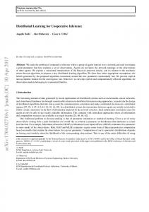
the number of times that a conditional CRLB result must be calculated), whereas our links selection techniques lead to O(0) and O(n) for NN-based and MCRLB-based schemes, respectively. However, selective cooperation, if not handled properly, may not be a relevant solution either (at least, in terms of localization error) due to uncontrolled poor GDOP conditions, as revealed by the performance of randomly selective schemes (approximately similar to that of exhaustive cooperation) in both S1 and S2. In a favorable steady-state regime when GPS is fully available and relatively precise (i.e., typically with a standard deviation equal to 3m), RSSI-based CP thus does not seem fully relevant, whereas significant gains through selective CP are mostly noticeable when GPS is seriously altered or even no more available (but not necessarily lost by cooperating neighbors in parallel), as practically illustrated in Fig. 3 and also Table I. In comparison with non-cooperative solutions, the worst-case error is thus improved with our proposal by about 25% over the whole trajectory and over the harsh/denied GPS portion indifferently. The median error is even decreased by 50% in the harsh/denied GPS portion only. Hence, the proposed solution enables reasonable continuity of the “ego” car navigation service at low complexity, opening the floor to contextual fusion through selective RSSI-based CP.
0 100
time [s]
Fig. 3. Ex. of localization performance as a function of time at a central “ego” vehicle (surrounded by 8 other vehicles) for different cooperative and non-cooperative schemes, when GPS signals are lost during the time interval from 60s to 80s (S2).
ACKNOWLEDGMENT EURECOM’s research is partially supported by its industrial members: BMW Group Research and Technology, IABG, Monaco Telecom, Orange, SAP, SFR, ST Microelectronics, Symantec. R EFERENCES [1] B. Kloiber, J. Harri, F. de Ponte Muller, and S. Sand, “Random transmit jitter against correlated packet collisions in vehicular safety communications,” in Proc. IEEE WiVeC’14, pp. 1–5, Sept 2014. [2] R. Parker and S. Valaee, “Vehicular node localization using receivedsignal-strength indicator,” IEEE Trans. on Veh. Tech., vol. 56, pp. 3371– 3380, Nov 2007. [3] D. Caveney, “Cooperative vehicular safety applications,” IEEE Control Systems, vol. 30, pp. 38–53, Aug 2010. [4] N. Drawil and O. Basir, “Intervehicle-communication-assisted localization,” IEEE Trans. on Intel. Transp. Syst., vol. 11, pp. 678–691, Sept 2010. [5] A. Boukerche, H. A. Oliveira, E. F. Nakamura, and A. A. Loureiro, “Vehicular ad hoc networks: A new challenge for localization-based systems,” Computer Communications, vol. 31, no. 12, pp. 2838 – 2849, 2008. Mobility Protocols for ITS/VANET. [6] M. Efatmaneshnik, A. Balaei, N. Alam, and A. Dempster, “A modified multidimensional scaling with embedded particle filter algorithm for cooperative positioning of vehicular networks,” in Proc. IEEE ICVES’09, pp. 7–12, Nov 2009. [7] J. Yao, A. Balaei, M. Hassan, N. Alam, and A. Dempster, “Improving cooperative positioning for vehicular networks,” IEEE Trans. on Veh. Tech., vol. 60, pp. 2810–2823, July 2011. [8] N. Patwari, A. Hero, M. Perkins, N. Correal, and R. O’Dea, “Relative location estimation in wireless sensor networks,” IEEE Trans. on Sig. Proc., vol. 51, pp. 2137–2148, Aug 2003. [9] Y. Bar-Shalom, Tracking and Data Association. San Diego, CA, USA: Academic Press Professional, Inc., 1987. [10] K. Das and H. Wymeersch, “Censoring for bayesian cooperative positioning in dense wireless networks,” IEEE JSAC, vol. 30, pp. 1835–1842, October 2012. [11] S. Zirari and B. Denis, “Velocity-based crlb predictions for enhanced cooperative links selection in location-enabled mobile heterogeneous networks,” in Proc. WPNC’13, pp. 1–6, March 2013. [12] L. Cheng, B. Henty, D. Stancil, F. Bai, and P. Mudalige, “Mobile vehicleto-vehicle narrow-band channel measurement and characterization of the 5.9 ghz dedicated short range communication (dsrc) frequency band,” IEEE JSAC, vol. 25, pp. 1501–1516, Oct 2007.