Dynamic Spatial Accessibility Modelling: Access as a Function of Time Olle Järv*, Henrikki Tenkanen, Maria Salonen, Tuuli Toivonen University of Helsinki Department of Geosciences and Geography Helsinki, Finland *
[email protected] Abstract Recent research in the field of transport and urban studies has recognized the need for more realistic spatial accessibility modelling regarding the incorporation of temporal dimension and multimodality for planning smart and sustainable cities with customer driven services. Here, we present a generic framework for dynamic urban accessibility modelling, where the three core components of accessibility - spatial population distribution, transportation network and service network - change as a function of time. This allows us to model more realistic urban accessibility patterns at any given point of time. We present our model and test its applicability in two case study areas – Helsinki, Finland and Tallinn, Estonia. We apply open data sources for information on the multimodal transportation network and service networks (e.g. food stores), and derive the distribution of actual population in time from Big Data such as mobile phone and social media data. Our findings contribute to the theoretical and methodological discussion on the ways of and the importance of integrating temporality and multimodality in accessibility modelling. Results indicate how dynamic multimodal accessibility modelling is essential for various up-to-date planning questions in comparison to more static accessibility measurements, and particularly useful for planning on-demand services for smart cities. Keywords: dynamic accessibility, space-time modelling, travel time, individual mobility, Big Data, public transport.
1
Background 2
We take the "mobilities turn" in social sciences at heart, and argue that accessibility research need to move beyond static residential locations of a “sleeping” people and integrate multidimensional temporality to accessibility modelling [1, 2]. In the age of the Big Data revolution human interactions through mobile devices create continuously spatially and temporally referenced digital footprints of people, and hence, mobile devices such as mobile phones and geolocated social media posts can be considered as proxies for people [3 – 5]. Big Data can enhance our understanding about individual human mobility as well as social processes and phenomena [6 – 8]. Thus, we consider that the actual distribution of people derived from Big Data can be implemented to accessibility research. Time is a function of accessibility given that the locations of people, the access through transport network, and opening hours of services depend on time. Furthermore, the cognition of travel time is closest to individual's embodied experience. Temporal dimension is acknowledged as an essential aspect to accessibility research only recently [9] whereas varying locations of people in time has not yet been taken into account. Hence, we aim to contribute to the theoretical and methodological framework of spatio-temporal accessibility research by proposing a novel framework where Big Data is applied for detecting actual locations of people in time, and combine it with a detailed multimodal travel time calculations using temporal information on both transport and service network. Our poster presents a conceptual framework for dynamic multimodal accessibility modelling, which allows us to explore the temporal variability of spatial accessibility patterns and reveal the influence of the actual distribution of people on accessibility measures in comparison to residential distribution.
Data and methods
We conduct an empirical case study in Helsinki, Finland and Tallinn, Estonia. We apply four data sets as the main components of accessibility: 1) Big Data such as anonymous mobile phone and geolocated social media data for representing population distribution; 2) open-access GTFS data for public transport up-to-date routes and schedules: 3) the national road network dataset to model travel times in the transportation network; 4) open-access opening hours of service network. We apply a place-based accessibility approach and perform routing calculations for different transport modes using advanced door-to-door approach [10], and use developed processing codes and tools openly available at GitHub (https://github.com/AccessibilityRG/SocialMedia). We calculate travel times and network distances at predefined 500 m grid cell resolution in different timeframes (hour of the day, day-of-week) during a month study period. We apply a multi-dasymetric approach to interpolate Big Data to represent the distribution of population suitable for accessibility modelling.
3
Results and discussion
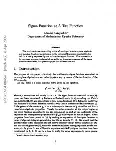
Results presented in the poster reveal spatio-temporal variations in accessibility by transport mode and time of day. Furthermore, dynamic accessibility modelling results indicate significant differences on accessibility to each service location in time while compared to static accessibility calculations derived from the distribution of residential locations. However, the main outcome of the research is a conceptual framework of the dynamic accessibility modelling emphasising the importance of temporality in the all three core components
AGILE 2016 – Helsinki, June 14-17, 2016
of accessibility (Figure 1) – access to services (e.g. food stores) depend on: 1) the spatial locations and opening hours of services (destinations); 2) the spatio-temporal distribution of people (origins); and 3) travel time of the available transport (medium) depending on the spatial layout of road network and traffic speed, and routes and timetables of public transport. Figure 1. the visualisation of the proposed conceptual framework for dynamic accessibility modelling.
[6] Ratti, C., Frenchman, D., Pulselli, R. M., Williams, S., 2006. Mobile Landscapes: using location data from cell phones for urban analysis. Environment and Planning B. 33(5): 727-748. [7] Hawelka, B., Sitko, I., Beinat, E., Sobolevsky, S., Kazakopoulos, P., Ratti, C., 2014. “Geo-Located Twitter as Proxy for Global Mobility Patterns.” Cartography and Geographic Information Science. 41(3): 260–71. [8] Järv, O., Muurisepp, K., Ahas, R., Derudder, B., Witlox, F., 2015. Ethnic differences in activity spaces as a characteristic of segregation: A study based on mobile phone usage in Tallinn, Estonia. Urban Studies. 52(14): 2680-2698. [9] Widener, M.J., Shannon, J., 2014. When are food deserts? Integrating time into research on food accessibility. Health Place. 30: 1-3. [10] Salonen, M., Toivonen, T., 2013. Modelling travel time in urban networks: comparable measures for private car and public transport. Journal of Transport Geography. 31: 143-153.
Additionally, we provide open-access tools and codes for the proposed dynamic spatial accessibility model (follow our work www.helsinki.fi/science/accessibility).
References [1] Sheller, M., Urry, J., 2006. The new mobilities paradigm. Environment and Planning A. 38(2): 207-227. [2] Kwan, M.-P., 2013. Beyond Space (As We Knew It): Toward Temporally Integrated Geographies of Segregation, Health, and Accessibility. Annals of the Association of American Geographers. 103(5): 10781086. [3] Ahas, R., Silm, S., Järv, O., Saluveer, E., Tiru, M., 2010. Using mobile positioning data to model locations meaningful to users of mobile phones. Journal of Urban Technology. 17(1): 3-27. [4] Gonzalez, M.C., Hidalgo, C.A., Barabasi, A.-L., 2008. Understanding individual human mobility patterns. Nature 453(7196): 779-782. [5] Kitchin, R., 2014. The Data Revolution: Big Data, Open Data, Data Infrastructures and Their Consequences. Sage.