Water 2015, 7, 217-247; doi:10.3390/w7010217
OPEN ACCESS
water ISSN 2073-4441 www.mdpi.com/journal/water Article
Empirical Modeling of Spatial 3D Flow Characteristics Using a Remote-Controlled ADCP System: Monitoring a Spring Flood Claude Flener 1,2, *, Yunsheng Wang 1,3 , Leena Laamanen 1 , Elina Kasvi 1 , Jenni-Mari Vesakoski 1 and Petteri Alho 1,4 1
Department of Geography and Geology, University of Turku, Turku FI-20014, Finland; E-Mails:
[email protected] (Y.W.);
[email protected] (L.L.);
[email protected] (E.K.);
[email protected] (J.-M.V.);
[email protected] (P.A.) 2 GWM-Engineering, Savilahdentie 6 L 20, Kuopio FI-70210, Finland 3 Department of Remote Sensing and Photogrammetry, Finnish Geodetic Institute, Geodeettinrinne 2, Masala FI-02431, Finland 4 Department of Real Estate, Planning and Geoinformatics, School of Science and Technology, Aalto University, Espoo FI-00076, Finland * Author to whom correspondence should be addressed; E-Mail:
[email protected]; Tel.: +358-2333-6094. Academic Editor: Miklas Scholz Received: 8 October 2014 / Accepted: 22 December 2014 / Published: 7 January 2015
Abstract: The use of acoustic Doppler current profilers (ADCP) for measuring streamflow and discharge is becoming increasingly widespread. The spatial distribution of flow patterns is useful data in studying riverine habitats and geomorphology. Until now, most flow mapping has focused on measurements along a series of transects in a channel. Here, we set out to measure, model and analyze the 3D flow characteristics of a natural river over a continuous areal extent, quantifying flow velocity, 3D flow directions, volumes, water depth and their changes over time. We achieved multidimensional spatial flow measurements by deploying an ADCP on a remotely-controlled boat, combined with kinematic GNSS positioning and locally-monitored water level data. We processed this data into a 3D point cloud of accurately positioned individual 3D flow measurements that allows the visual analysis of flow velocities, directions and channel morphology in 3D space. We demonstrate how this allows monitoring changes of flow patterns with a time series of flow point clouds measured over the period of a spring flood in Finnish Lapland. Furthermore, interpolating the raw point cloud onto a 3D matrix allows us to quantify volumetric flow while reducing
Water 2015, 7
218
noise in the data. We can now quantify the volumes of water moving at certain velocities in a given reach and their location in 3D space, allowing, for instance, the monitoring of the high-velocity core and its changes over time. Keywords: acoustic Doppler current profilers (ADCP); Global Navigation Satellite System (GNSS); 3D flow measurement; spatial flow; 3D flow field; streamflow; empirical model; high resolution; point cloud; high velocity core; spring flood; river; Finland
1. Introduction The flow characteristics of water in a river influence both the channel morphology and the riverine habitats, which are of great interest to fluvial scientists and engineers alike, for instance in the fields of hydro-power or other in-channel construction, as well as habitat restoration [1] or pollution dispersion [2]. These are complex dynamic processes that have thus far been challenging to map over a continuous spatial extent. The spatial distribution of flow patterns is useful knowledge in studying riverine habitats [3] and geomorphology [4], especially in meander bends, where the distribution of flow velocities is non-uniform, both in the down-stream and the cross-stream direction [5,6]. Flow field data of high spatial resolution will be beneficial for investigations of fluvial processes—especially in river channels with complex flow structures, such as meandering or braided channels, at confluences or diffluences or around engineered objects, such as dams or bridge pylons, to name but a few—as well as in calibrating and validating computational models over complex river reaches. The use of acoustic Doppler current profilers (ADCP) for measuring streamflow [7] and discharge is becoming increasingly widespread [8]. The principles of the operation of ADCPs are described in great detail, for instance, in Muste et al. [9] and Gunawan et al. [10]. Briefly, ADCP measurements derive flow velocity from the Doppler shift of the measured return of an emitted acoustic signal that is reflected off suspended matter in the water column. The information from a combination of several (usually three or four) acoustic beams is used to calculate the mean velocity and flow direction, based on the assumption that the acoustic scatterers move at the same speed as the water and that flow is homogeneous over the area covered by the beams. These locally-averaged flow measurements are split vertically into cells (bins) that each represent a flow vector at a certain depth. When deployed from a moving vessel, a series of these velocity components measured perpendicular to the cross-section produces a transect of flow vectors across a stream, usually represented in the form of a raster, where each raster cell represents one flow vector. Generally, this series of measurements in a transect is used to calculate discharge. Several researchers have used a series of such transect measurements to analyze flow characteristics in natural streams [11,12]. Most flow mapping has focused on measurements along a series of transects in a channel measured using either an ADCP [13–16] or an acoustic Doppler velocimeter (ADV) [17–20]. Parsons et al. [15] developed a set of software tools that facilitates the analysis and visualization of such transect-based measurements, and they showcase several impressive examples where a series of transects is used to
Water 2015, 7
219
characterize the 3D flow of several river reaches. The transect-based approach gives insight into the flow field in 3D, along the transect and through the water column. This approach is, however, limited in providing information of the areal flow field over a river reach, leaving considerable gaps between the transects. Another approach is to employ sampling trajectories that move beyond the classical transect arrangement towards a more spatial coverage, either surveying a dense pattern of transects intended for spatial interpolation [21] or employing a spatially irregular or continuous survey pattern [22–25], employing real-time kinematic GPS for accurate positioning of the flow measurements. This approach allows the investigation of the areal flow field by generating, for instance, depth-averaged flow maps along with bathymetry maps. However, the third dimension of flow variation in the water column is not represented in a 2D flow field map. Dinehart and Burau [22] interpolated ADCP-measured flow vectors onto a 3D grid in order to represent the flow field in three dimensions at the reach scale. Tsubaki et al. [26] also presented an interesting interpolation method for modeling the 3D flow distribution based on ADCP-measured data, dividing the flow data into depth layers, thereby creating an areal 3D flow field. However, a method for rapidly measuring and visualizing areal 3D flow field data and visualizing it in a virtual 3D environment for analysis has thus far not been presented. The aim of this paper is to measure, model and analyze multitemporal 3D flow characteristics of a natural river over a continuous areal extent, quantifying flow velocity, 3D flow directions, volumes, water depth and their changes over time: First, we present a measurement and empirical modeling method that combines areal ADCP flow data with highly accurate positional data to yield a 3D point cloud of measured flow properties. The new processing method presented makes it possible to represent the raw measured three-dimensional flow field at the reach scale in a virtual 3D environment. Second, we demonstrate how this methodology can be used to capture river reaches at different scales and resolutions, from a several km-long reach at a coarse resolution, down to focusing on one meander bend at high resolution. Third, we model and analyze the 3D flow field in a meander bend over a two-week time period of a snow-melt-induced flood event. We analyze the spatial distribution of the high-velocity core and its movement, as well as changes in vertical flow patterns and river bed topography over the time period of the flood event. Finally, we use a 3D interpolation to transform the raw data onto a regular grid, which enables us to conduct a quantitative analysis of flow volumes and the volumetric distribution of different flow velocities in a given reach of a river. The focus of this paper is on presenting the survey and empirical modeling methodology representing raw measured flow data as a 3D point cloud and to show how it can be applied to analyze 3D flow fields. A detailed geomorphological analysis will be the subject of a future publication and is therefore beyond the scope of this work.
Water 2015, 7
220
2. Study Area The field data for this study was collected from a 3.7-km reach of the Pulmanki River in Northern Lapland (69◦ 56' N, 28◦ 2' E). The Pulmanki River flows in a valley of glaciofluvial deposits surrounded by fell country. The river meanders northwards into Lake Pulmanki on the Finnish side and flows out of the lake on the Norwegian side to continue its flow towards the Tana River. Our study area is located immediately upstream of Lake Pulmanki. The study reach includes eight meanders. We placed particular focus on one meander bend where we collected data at a higher spatial and temporal density than in the whole reach in order to be able to compare the utility of this methodology at different scales. The meander bend area of interest (AOI) is 220 m in length and is located 1 km upstream of Lake Pulmanki, with a thalweg distance of 1.8 km (Figure 1).
Figure 1. (A) Map locating the study area showing the Tana River watershed and the Pulmankijoki sub-watershed in grey, with the study reach marked in red; (B) Point cloud of raw measured flow data of the meander bend AOI (220 m) on 17 May 2013, visualized in CloudCompare, looking downstream. The coloring represents horizontal flow velocity (m/s). In our study area, the Pulmanki River is about 20–30 m wide during summer low flow, depending on the water level. The riverbed consists mostly of sandy sediments. These sediments accumulate as point bars on the inside of the meanders. Kasvi et al. [6] and Alho and Mäkinen [27] describe the geomorphology of this study site in great detail. The typical discharges of the Pulmanki River vary between about 4 m3 s−1 during summer low flow and 70 m3 s−1 during the annual snow-melt-induced spring flood. The water level can be two to four
Water 2015, 7
221
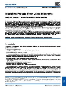
meters higher during flood time than during summer low flow, depending on the size of the flood. Fieldwork for this study captured the rising stage of the spring flood during the latter half of May 2013. 3. Methods and Data We set out to create a model of measured flow characteristics that is spatially accurate in 3D and contains flow velocities and 3D flow directions of a spatially continuous area as a time-integrated snapshot of the measurement period of about two hours. The way we represent spatial flow data in 3D is as a LiDAR-like (light detection and ranging) point cloud [28] that contains flow parameters as scalar fields. Unlike a LiDAR point cloud, which generally aims to represent primarily the surface of a 3D object, the point clouds we create here contain data from the entire water column. Furthermore, unlike a LiDAR point cloud, this one is semi-systematic in its structure, that is the points are irregularly spaced, but they are vertically stacked, albeit at varying vertical spacing. Creating multidimensional flow data point clouds involves a range of field methods and data post-processing. Figure 2 shows the main components of the set-up in the field and how the field measurements relate to the final data product. The process is described in detail below. A Point cloud of flow parameters Point cloud of water surface elevations GPS antenna
Remote controlled boat
VRS/RTK-GNSS reciever
Point cloud of river bed elevations
ADCP
B Transect GPS antenna
Hydroboard
ADCP
Figure 2. Diagram of the flow measurement set-up and concept. (A) The new spatial modeling of flow vectors as a 3D point cloud containing surface points, flow velocity and direction points in the water column and river bed elevation points; (B) This subfigure contrasts the more traditional method of representing flow as a series of transects. 3.1. Field Data We conducted field measurements during a nine-day period (16–24 May 2013) that included the rising stage of the spring flood. Flow measurements were conducted daily at the meander bend AOI and every second day over the whole reach studied. Measurements of the meander bend AOI took about two hours to complete.
Water 2015, 7
222
3.1.1. Remote-Controlled ADCP We used a Sontek RiverSurveyor M9 ADCP mounted to a custom-built remote-controlled mini-boat (RCflow) to survey a dense pattern of flow measurements at the meander bend AOI. The boat is 1.43-m long and 0.425-m wide with the sensor emerging from the hull without its edge protruding at a water depth of 0.06 m. The hull is designed to minimize drag and turbulence, so that the boat can move against a fairly strong current and cause minimal interference to the measurements. RCflow makes it possible to survey even shallow reaches in sub-meter depths that cannot be accessed by larger boats. The boat is propelled by an electric motor powered by either NiCad or LiPo battery sets providing 20,000 mA/h. This allows for uninterrupted measurements exceeding 2 h, depending on flow conditions and the load required. To measure the long reaches of the study area, we mounted a Sontek S5 ADCP to a Hydroboard floating platform attached with a pole to a motorboat (Figure 3). This allowed us to cover a greater distance and better cope with the current than the battery-operated RC boat. We aimed for boat speeds not exceeding 1 ms−1 .
Figure 3. ADCP-GNSS set-up on a remote-controlled boat (A) and on the Hydroboard tethered to a zodiac (B). A Trimble R8 GNSS receiver is mounted on the GPS pole of the ADCP exactly above the sensor, and the ADCP’s GPS antenna is mounted on the deck of the vessel. Both ADCPs had the SmartPulseHD feature enabled. Using this measurement mode, the sensor simultaneously emits coherent and incoherent pulses, potentially at multiple frequencies, and a processing algorithm selects the best return signal for the given water depth and velocity. The Sontek M9 uses 3.0-MHz, 1.0-MHz and 0.5-MHz and the S5 uses 3.0-MHz and 1.0-MHz pulses. The ADCP sample measurements were carried out in discharge measurement mode using the ADCPs’ differential GPS (DGPS) for tracking. Bottom tracking was not an option, because the sandy river bed is mobile during the spring flood. Measurements were collected in a zig-zag pattern as very long transects and later exported as raw data in MATLAB format. The ADCPs measure one sample (also referred to as an ensemble) each second, and each sample is divided vertically into separate cells, also referred to as bins. The number of cells depends on water depth, and the cell height is dynamically adjusted depending on depth and speed. Measurement cells may be as small as 2 cm in shallow (