This article appeared in: Proceedings of the 20th International Conference on Informatics for Environmental Protection EnviroInfo 2006, Graz
Spatial data infrastructure techniques for flexible noise mapping strategies Angela Czerwinski1 , Thomas H. Kolbe1, Lutz Plümer1 and Elke Stöcker-Meier 2
Abstract The implementation of the EU Environmental Noise Directive puts high demands on the access, availability and integration of numerous thematic and geographical information. Till now high expenses in time and finances arise for noise mapping because of several technical problems in thematic and geometric data generation and integration. To evaluate the status quo of noise mapping in North Rhine-Westphalia, a state of Germany, a feasibility study was conducted by the Institute for Cartography and Geoinformation of the University of Bonn on behalf of the State Ministry of Environment, Nature Conservation, Agriculture and Consumer Protection of North Rhine-Westphalia. An important result of this study is, that financial savings in the context of environmental noise mapping can be made by the sustainable use of geoinformation in the context of Spatial Data Infrastructures (SDI), especially as a flexible use of geodata for decentralised and centralised noise mapping tasks as well as for small and large-sized areas is required. Applications of web mapping services and international standards of Open Geospatial Consortium and ISO already are in common use in many thematic fields. New challenges are the implementation of web services for 3D building models and cadastral information, which both are required for the environmental noise mapping. In this paper we will discuss how different strategies for environmental noise mapping are facilitated by the consequent application of Spatial Data Infrastructure techniques.
1.
Introduction
The use of geoinformation in the environmental sector got a new challenge by the commencement of the EU Environmental Noise Directive 2002/49/EG (END) in 2002 and its transposition into German law (§ 47 a-f of Federal Immission Protection Law) in 2005. The END obligates the EU member states to map environmental noise in urban agglomerations, along major roads and major railways, and in the surroundings of major airports as well as to draw up action plans. To map the environmental noise in Germany, several different actors have to cooperate closely (municipalities, federal and state authorities, operators and consultants). The responsibilities for the implementation of the END are handled differently in the EU countries, and for the different kinds of noise. Therefore an information technology concept will be necessary, which represents this differentiation. The required accuracy and resolution of implementation ask for highest demands on thematic and geometric data. The Institute for Cartography and Geoinformation of the University of Bonn has carried out a feasibility study for the implementation of the END in North Rhine-Westphalia, on behalf of the State Ministry of Environment, Nature Conservation, Agriculture and Consumer Protection of North Rhine-Westphalia (Plümer et al. 2006). The content of the feasibility study was to analyse how the implementation of the END in North Rhine-Westphalia could be performed appropriately, in due time, cost-efficient and sustain-
1
Institute for Cartography and Geoinformation, University of Bonn, Meckenheimer Allee 172, D-53115 Bonn, {czerwinski⎟ kolbe⎟ pluemer}@ikg.uni-bonn.de 2 State Ministry of Environment, Nature Conservation, Agriculture and Consumer Protection of North Rhine-Westphalia, Schwannstr. 3, D-40476 Düsseldorf,
[email protected]
19.05.2006, Czerwinski.doc
1
able. As well the study identified savings potentials and alternative options for action. The focus was on the provision of databases, which will be required for the environmental noise mapping. Therefore the study included a to-be analyse, which identified the legislative demands on the environmental noise mapping in North Rhine-Westphalia. As well the study worked out an as-is analyse, which describes the status quo of noise mapping in North Rhine-Westphalia and the present experiences. For this analyse all concerned actors had been interviewed selecting representative examples (municipalities and state authorities, consultants and software companies, organisations and working groups). The maxim was an objective inventory and assessment from the point of view of an independent research institute. Taking into account the results of both analyses, restraints and improvement possibilities had been evaluated and alternative options of action had been proposed for the implementation of the END in North RhineWestphalia. In the following chapters the requirements of EU legislation, the status quo of noise mapping in North Rhine-Westphalia as well as restraints in provision and integration of geoinformation will be discussed. Afterwards possibilities of a flexible noise mapping implementation strategy will be presented by the use of Spatial Data Infrastructure techniques.
2.
Requirements of the EU Environmental Noise Directive
The END poses new demands on noise mapping, which had not been part of the previous legislation on noise reduction in Germany: in future a large-area strategic noise mapping is required in urban agglomerations and along concerned major roads and railways. The noise mapping is conducted separately for each kind of noise: road traffic noise, rail traffic noise, aircraft noise around airports, and noise on industrial activity sites (including harbours). New assessment parameters and methods are determined. Furthermore an obligatory schedule is prescribed including a revision in a 5-years frequency. In Germany the municipalities are initially responsible for the environmental noise mapping (except for railways in federal ownership). Due to these demands several restraints arise in the context of environmental noise mapping: timeand cost-consuming data flows especially of (3D) geodata, excessive personal demand especially in municipalities < 100.000 habitants as well as a missing use of homogeneous basis data can be observed.
3.
Status quo of environmental noise mapping in NRW
So far environmental noise mapping had been carried out only in few municipalities of North RhineWestphalia. This environmental noise mapping mostly did not consider all kinds of noise required in the END. In all previous mappings the municipal road traffic had been considered, partly as well the municipal railway traffic (train or tramway). In particular cases air traffic and industrial sites had been mapped. Rarely the environmental noise mapping had been continued several times. Some municipalities delegated parts of the environmental noise mapping to external consulting engineers. Demands on the geodata required by the environmental noise mapping will in future depend on current noise mapping regulations, noise mapping software tools and required accuracy (see EU Good Practice Guide 2005). The results of the feasibility study illustrate, that thematic and geometric data required for EU environmental noise mapping exist only partly in municipalities > 100.000 habitants and > 250.000 habitants and almost not in municipalities < 100.000 habitants. In contrast geodata of the State Surveying and Mapping Agency and of the State Enterprise of road development are statewide available and applicable (Digital Terrain Model 1:5.000, ALK, ATKIS road and railway data, state road traffic data). In Germany cadastral information is provided by the systems ATKIS, ALK and composed of vector data (Busch/Willrich 2002).
19.05.2006, Czerwinski.doc
2
Concerning the expenditure of time of environmental noise mapping so far, most part of time was spent on the provision, processing and integration of thematic and geometric data (approx. 90 %). In contrast a small part had been invested in the proper noise calculation and preparation of noise maps. An exceptionally part of time was spent in homogenisation and processing of geometric data (approx. 30 %) as well as in thematic data acquisition of road traffic noise and noise on industrial activity sites. Equally the highest financial expense arised for data acquisition and integration so far. A particular part (35,8 %) was spent on the provision of (3D) geodata, especially of DTM and 3D building models. Another notable part was invested in road traffic noise (24,3 %) and noise on industrial activity sites (18,6 %). Not to be ignored should be the expenses for investigation of the number of exposed people, especially for concerned municipalities < 100.000 habitants, as well as for special noise mapping software tools. Beyond it is becoming evident, that data acquisition and integration ask a high staff employment as well as high professional competence in acoustics and geodata management.
4.
Provision and integration of geoinformation as a key problem
Considering geoinformation technology and sustainability of the previous environmental noise mapping, some problems of integration, storage and continuation of geodata are identified. These problems can cause on the one hand mistakes in noise calculation and on the other hand elevated expenses in time and finances. These problems themselves are caused by missing interoperability of the required geodata as well as by a missing concept of sustainable data storage and continuation (e.g. multiple data storage and continuation, no use of international exchange formats, no homogeneous data processing techniques, no consistent data models). Especially affected are (3D) geodata like DTM, 3D building models and road traffic data. Concerning the integration of geodata in the context of environmental noise mapping, the following interoperability problems can be observed: Problems of syntactic interoperability arise, if the compatibility of different data and file formats is not assured, e.g. files of municipal geographical information systems cannot be imported in noise mapping software programs or converted to their proprietary format (see Bishr 1998). Problems of geometrical interoperability result from geometric data, which do not match together spatially and cause inaccuracy in position, e.g. of roads and buildings to each other (road passes through a building). Problems of semantic interoperability arise, if objects are described differently in thematic or geometric data using different data models, e.g. different definitions of the same road section in different data sets. As well there are problems of integrating noise maps of adjacent municipalities consistently. As previous environmental noise mapping had been carried out only for single municipalities or small areas, a coordination of adjacent municipal areas had not been necessary and is missing. Furthermore almost no continuation of environmental noise mapping took place so far and therefore, few experiences in the replacement of parts of noise maps exist. The storage of input data in the context of environmental noise mapping mostly takes place twice or multiple times, often in proprietary files and without using databases. A twice or multiple storage of the same data occur e.g. for the DTM originally in the State Surveying and Mapping Agency, in copy in the municipalities and processed in the noise mapping software. Till now the costly generated 3D geodata had mostly not been used for multiple applications, because the storage was intended to be only in the noise mapping software and a backflow to the municipal data pool was not assured. The problem of the continuation of input data in the context of environmental noise mapping consists of a double data continuation: of the original data at the place of origin as well as of the data in noise mapping software. This data continuation mostly does not take place analogously. This means data modification takes place in the noise mapping software, which has no backflow to the original data (e.g. adjustment of the road course relatively to the buildings). Accordingly all these modifications have to be added again 19.05.2006, Czerwinski.doc
3
at each mapping iteration or each new data import. Furthermore, data modifications are performed at the place of origin, but are not concerned in the input data of noise mapping (e.g. adjustment of building data). To calculate environmental noise 3D building models are required in a simple form without any roofs (3D blocks models in the level of detail LOD1). A detailed definition of all levels of detail can be found at Kolbe et al. 2005. So far the generation of 3D blocks models is executed mostly without using laser scan data (of the State Surveying and Mapping Agency or the municipalities). Mostly building heights are generated through cost- and time-consuming, often manual methods: estimation of heights on site and manual data integration, measurement of heights on site, determination of numbers of storeys from development plans, or analysis of aerial photographs. Existing municipal 3D building models had only been used in a few cases so far. The import of these existing 3D blocks models in the noise mapping software is depending on the provision of the according interfaces in the software. Because of the often used manual 3D geodata generation methods, high expenses in time and finances resulted for the provision of 3D geodata in the context of noise mapping so far. A reason therefore is as well, that 3D geodata mostly are regenerated in the noise mapping software instead of using existing ones. Till now the costly generated 3D geodata had mostly not been used for multiple applications, because the storage was intended to be only in the noise mapping software and a backflow to the municipal data pool was not assured.
5.
Strategies for noise mapping
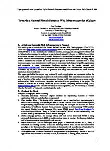
As described in the chapter above, the implementation of the EU environmental noise mapping causes not only organisational problems, but also technical ones, which provoke high financial expenses. Concerning both problems, three different strategic possibilities can be considered: a completely decentralised processing, whereas all concerned municipalities would execute the implementation and noise calculation, a completely centralised processing by a central unit, or a regional bundling of processing. It was identified, that not one of these strategies will be appropriate to be realised for all kinds of noise, but that each kind of noise needs its suitable strategy. Hence a differentiated solution depending on the kinds of noise appears as the most effective one, especially regarding the existing geodata and the use of a Spatial Data Infrastructure (see Fig. 1). The differentiated solution implies a mix of centralised and decentralised elements of noise mapping processing. Thereby a centralised processing does not mean the use of a central database solution. The bundling of data provision and noise calculation will be executed in the costintensive domains, where competences for an appropriate processing of the END in due time is missing. A differentiated solution does as well mean a flexible integration of the urban agglomerations. I.e. the agglomerations can process the noise mapping decentralised on their own using the provision of state geodata via Spatial Data Infrastructures, and the small municipalities along major roads are discharged through a centralised processing. A Spatial Data Infrastructure will allow a flexible use and provision of the required (3D)geodata and solve most of the technical and organisational problems of geodata integration in the context of noise mapping.
6.
Advantages of a spatial data infrastructure in the processing of environmental noise mapping
The following demands on a sustainable environmental noise mapping can be summarised from the discussions of the last chapters: avoidance of redundant data storage, continuation exclusively of the original data as well as the use of homogenous data models, generation methods and accuracies. Appropriate strategies, which will correspond to these demands, will be discussed in the following.
19.05.2006, Czerwinski.doc
4
Major railways centralised
Major roads centralised
Roads and tramways agglomerations
Industrial sites centralised
Airports regional
Noise maps
Noise calculation
Internet – Web Services
Data provision
interoperable interfaces
ATKIS (roads, State road data railways), DTM5 3D Blocks model State Enterprise address data traffic & transport
State surveying
Address data Road data
Data German railway
municipalities
Tramway data transportation companies
Data Industral sites harbours
Data airports
Figure 1 Differentiated solution implementing a spatial data infrastructure in the realisation of EU environmental noise mapping. Source: IKG Uni Bonn Instead of proprietary formats or multiple stored and continued data sets, geodata required for the environmental noise mapping may also be stored and used in interoperable systems. An application of international standards along with Spatial Data Infrastructures SDI (ISO & Open Geospatial Consortium OGC) would enable these interoperable systems in the context of EU environmental noise mapping. The flexibility of a SDI permits as well the flexible definition of decentralised or centralised processed parts of the environmental noise mapping. Important is, that the required geodata is provided in a distributed data storage via OGC/SDI web services (Altmaier/Kolbe 2003). Thereby the required geodata remain decentralised at their place of origin in the owners’ databases and will be retrieved by web services, e.g. for the access to State road traffic data (via Web Feature Service) and to (3D) geodata of the State Surveying and Mapping Agency (via Web Coverage Service and Web Feature Service). A continuation will take place exclusively at the place of origin. Modifications will be automatically retrieved by the geodata users via web services at their different locations of use. Hence spatial data infrastructure methods consider the situation of the cadastral competences of municipalities. Municipalities (i.e. urban agglomerations) should be allowed to reuse optionally to the centralised processed parts their already completed noise mappings as well as their provision of high resolution geodata, especially concerning 3D building models, on the condition, that the geodata exceed minimum requirement of accuracy of DTM 1:5.000 and 3D blocks model LOD1. The realisation of web services should be embedded in existing SDIs like the Geodata Infrastructure North Rhine-Westphalia (GDI NRW, www.gdi-nrw.org, Brüggemann et al. 2004). Thus existing technical infrastructure can be reused, e.g. the services of the State Department for Computing and Statistics. The GDI NRW itself is embedded in the Geodata Infrastructure of Germany (GDI-DE, www.gdi-de.de) as
19.05.2006, Czerwinski.doc
5
well as in the EU INSPIRE initiative encouraging the development of SDIs in all EU member states (www.ec-gis.org/inspire, Bernard et al. 2005). The implementation of a SDI is based on the successful application of web services. There is already a many years’ experience in the implementation of web services: Web Map Services (WMS) are already proved in multiple cases and Web Coverage Services (WCS) in many cases (Sandmann 2005, Remke et al. 2004). A WMS may be used for the presentation of final noise maps to the public. Existing techniques of Web Feature Services (WFS) can be used or expanded, e.g. for State road traffic data in North RhineWestphalia. Concerning the ATKIS geodata of the State Surveying and Mapping Agency, a WFS is not yet realised, but envisaged shortly. These web services could be used as well for further applications in the GDI NRW. A WFS based on the CityGML schema for 3D blocks models LOD1 of the State Surveying and Mapping Agency will be an ambitious combination of the status quo of web service techniques with a sustainable solution of noise mapping problems. The homogenisation of 3D data models for the data transfer between data providers, users and noise mapping software is of particular importance to assure comparable results and quality as well as to reduce expenses. This concerns especially 3D geodata like DTM and 3D building models. The data modelling of CityGML version 1.0 is a homogeneous description of 3D objects for data storage (semantical and geometrical description). CityGML is an open data model and an XML-based format for data storage and exchange of 3D building models (www.citygml.org, Kolbe et al. 2005, Kolbe et al. 2006). It is an application scheme of GML3 (Geography Markup Language 3, Cox et al. 2004), which is the international standard for geodata exchange of the Open Geospatial Consortium (OGC) and the International Organisation for Standardisation (ISO TC211). CityGML represents not only graphical elements of a 3D building model, but especially sementical and thematical properties like taxonomy and aggregation of DTM, sites (buildings, bridges, tunnels), vegetation, water bodies, transportation and city furniture (see Fig. 2). The model differentiates five consecutive levels of accuracy (levels of detail LOD 0-4). Accuracy increases regarding geometry and thematical properties from LOD0 to LOD4. CityGML data sets may have multiple representations of one object in different LOD. As well there is the possibility to represent explicitly generalisation correlations between objects of different LOD (e.g. a certain building block in LOD1 is represented in LOD2 in several single building elements). Furthermore CityGML includes a concept for generic city objects to model features not provided explicitly by the CityGML schema. All city objects can have any generic attributes. The base class of all thematic classes in CityGML is CityObject. CityObject is a subclass of the GML class Feature and thus inherits metadata and names from Feature and its super classes. The subclasses of CityObject comprise the different thematic aspects shown in the UML diagramm in Figure 2 (for Unified Modeling Language see Booch et al. 1997). The thematic classes have further subclasses with relations, attributes and geometry. Important characteristics of CityGML in the context of environmental noise mapping are a flexible integration and presentation of different DTM (e.g. DTM of different accuracy from the State Surveying and Mapping Agency and from municipalities). As well 3D building models of different accuracy (LOD 1-3) from different places of origin can be integrated, e.g. 3D blocks models LOD1 and LOD2. City furnitures may be used to represent e.g. noise barriers. Furthermore generic objects and attributes can be used for objects, which are not explicitly modelled yet, e.g. noise barriers, tunnels, attributes of roads and railways like road surface type, road traffic flow, number of trains. CityGML has been worked out by the Special Interest Group SIG 3D of the GDI NRW in the last years. Participating members of the SIG 3D are nationwide operating companies, institutions and universities. CityGML has already been presented in the OGC and EuroSDR and will be submitted as specification proposal in the OGC. The consideration of sustainability in the context of environmental noise mapping is essential for the iterations in a 5-years frequency. This includes a homogenous geodata continuation explicitly at the place of origin (avoidance of multiple data storage and continuation). It is especially important for 3D building
19.05.2006, Czerwinski.doc
6
models, which are stored multiple times in the noise mapping software, in the municipal department of cadastral affaires, and in the State Surveying and Mapping Agency so far. As well the data storage should be carried out in databases. To assure the sustainability a backflow of geodata to municipalities (e.g. results of noise calculation) and a multiple use of geodata will be of outstanding importance. gml:: _FeatureCollection
gml:: _Feature +name[0..*]: gml: CodeType
gml:: CodeType +name[1]: xs:string +codeSpace[0..1]: xs:anyURI ExternalObjectReference +name[1]: xs:string +uri[1]: xs:anyURI
generalizationRelation externalObjectReference
* CityObjectMember
CityModel
*
*
_CityObject +creationDate[0..1]: xs:date +terminationDate[0..1]: xs:date
LandUse
ReliefFeature
*
GenericCityObject
CityFurniture
externalReference *
*
ExternalReference +informationSystem[0..1]: xs:anyURI
_VegetationObject
_TransportationObject
_WaterObject
CityObjectGroup
_Site
+lod[0..1]: integerBetween0and4
_AbstractBuilding
Figure 2 UML diagram of the top level class hierarchy of CityGML. Source: IKG Uni Bonn
7.
Conclusion and further work
Financial savings in the context of environmental noise mapping will arise from a sustainable use of geoinformation and an application of spatial data infrastructures. As a flexible use of geodata for decentralised and centralised tasks of the environmental noise mapping by different responsible units is required, the environmental noise mapping is a very good example for the real application of SDIs. This is essential, because large-area thematic and geometric data are required and local municipal geodata must be integrated. Therefore the large-area application of geodata from the State Surveying and Mapping Agency as well as of State road traffic data via SDI web service would allow a strengthening of State services for further applications. New challenges in the implementation of SDIs are the provision of ATKIS data and 3D building models via web services (Web Feature Service). As the environmental noise mapping requires obligatory the third dimension of geodata, the exchange of 3D geodata via web services and international standards is of particular importance. Especially a web service for the automatical integration and homogenisation of 3D object is of special interest. Already now the exchange of 3D geodata via Web Feature Services is possible through the development of CityGML. CityGML covers the four main aspects of 3D spatial objects and 19.05.2006, Czerwinski.doc
7
terrain, i.e. geometry, topology, appearance, and semantic resp. thematic properties. The ability of maintaining different levels of detail makes it suitable for small to large area utilization in the context of noise mapping. As a conclusion of the diversity of existing and required geodata in the context of environmental noise mapping, the linking of thematic data attributes and geometric data should always be considered. Thematic data attributes should not be collected with their own geometry, as this may cause time-consuming and expensive problems of data integration. Important for the implementation of SDI techniques in thematic topics like the EU environmental noise mapping are early strategic decisions.
Bibliography Altmaier, A., Kolbe, T.H. (2003): Applications and Solutions for Interoperable 3d Geo-Visualization, in: Fritsch, Dieter (eds.): Proceedings of the Photogrammetric Week 2003, Stuttgart. Bernard, L., Annoni, A., Kanellopoulos, I., Millot, M., Nogueras Iso, J., Nowak, J., Tith, K. (2005): What does INSPIRE need? – Development and research requirements, in: Proceedings, 8th AGILE Conference on GIScience, Estoril. Bishr, Y. (1998): Overcoming the semantic and other barriers to GIS interoperability, in: International Journal on Geographical Information Science, 12(4). Booch, G., Rumbaugh., J., Jacobson, I. (1997): Unified Modeling Language User Guide. Addison-Wesley. Brüggemann, H., Sandmann, S., Riecken, J. (2004): The GDI.NRW as a component of the German, European and Global Spatial Data Infrastructure, in: Proceedings, GSDI-conference 2004, Bangalore. Busch, A., Willrich, F. (2002): Quality management of ATKIS data, in: Proceedings of OEEPE/ISPRS Joint Workshop on Spatial Data Quality Management, 21-22 March 2002, Istanbul. Cox, S., Daisy, P., Lake, R., Portele, C., Whiteside, A. (2004): OpenGIS Geography Markup Language (GML 3.1), Implementation Specification Version 3.1.0, Recommendation Paper, OGC Doc. No. 03-105r1. European Commission Working Group Assessment of Exposure to Noise (WG-AEN) (eds.): Position Paper - Good Practice Guide for Strategic Noise Mapping and the Production of Associated Data on Noise Exposure, Version 2, Draft 3, november 2005, unpublished (Version 1 see http://www.imagine-project.org/artikel.php?ac=direct&id=224). European Union (eds.): Directive 2002/49/EG of the European Parliament and of the Council of 25 June 2002 relating to the assessment and management of environmental noise [END], in: Official Journal of the European Communities from 18.7.02. Federal Government of Germany (eds.): Gesetz zur Umsetzung der EG-Richtlinie über die Bewertung und Bekämpfung von Umgebungslärm vom 24. Juni 2005, in: Bundesgesetzblatt Jg. 2005, Teil 1, Nr. 38, Bonn 29.6.05, Internet: http://217.160.60.235/BGBL/bgbl1f/bgbl105s1794.pdf. Kolbe, T. H., Gröger, G., Plümer, L. (2005): CityGML - Interoperable Access to 3D City Models, in: van Oosterom, Peter, Zlatanova, Sisi, Fendel, E.M. (eds.): Geo-information for Disaster Management. Proc. of the 1st International Symposium on Geo-information for Disaster Management, Delft. Kolbe, T. H., Gröger, G., Plümer, L. (2006): CityGML - 3D City Models for Emergency Response, in: Geoinformation-Technology for Emergency Response, ISPRS book series, Taylor & Francis. Plümer, L., Czerwinski, A., Kolbe, T. H. (2006): Machbarkeitsstudie zur Umsetzung der EUUmgebungslärmrichtlinie in NRW, Bonn. Remke, A., Altmaier, A., Riecken, J. (2004): Operational core of GDI NRW set up – joint project 2004, in: Proceedings, 10th EC-GI & GIS Workshop ESDI, Warsaw. Sandmann, S. (2005): TIM-online - a part of the egovernment strategy by the Federal State North-Rhine Westphalia, in: Proceedings, 8th AGILE Conference on GIScience, Estoril.
19.05.2006, Czerwinski.doc
8