Evolutionary deployment and local search-based movements of 0th responders in disaster scenarios D. G. Reina*1, T. Camp*2, A. Munjal*3, S. L. Toral*4 *1 Engineering Department, Campus Palmas Altas, Edificio E, 41014, Seville, Spain. *2 Computer Science Division, Colorado School of Mines. 1500 Illinois Street, Golden, Colorado, USA. *3 Senior Software Engineer, Testplant Inc., Boulder, Colorado, USA.
*4 Electronic Engineering Department, University of Seville. Camino de los Descubrimientos S/N, 41092, Seville, Spain.
Corresponding author: D. G. Reina,
[email protected] Abstract: The establishment of communications in disaster scenarios is of paramount importance, especially because preexisting communication infrastructure is likely to be destroyed or malfunctioning. Consequently, there is a need for an alternative and self-organizing communication infrastructure that can be rapidly deployed in disaster situations. In this paper, we propose to use drones or unmanned aerial vehicles as 0th responders to form a network that provides communication services to victims. Finding the best positions of the 0th responders is a non-trivial problem and is, therefore, divided into two phases. The first phase is the initial deployment, where the 0th responders are placed using partial information on the disaster scenario. In the second phase, which we call the adaptation to real conditions, the drones move according to a local search algorithm to find positions that provide better coverage to the victims. We conduct extensive simulations to validate our proposed approach for rural disaster scenarios under different conditions. We show that our proposed initial deployment based on genetic algorithm provides coverage for up to 94% (maximum) and 86% (mean) of victims if complete knowledge of the disaster scenario is known and 10 drones are used. When the adaptation to the real condition phase is used, this percentage is increased to 95% (maximum). If no knowledge of the scenario and 10 UAVs are used 80% (maximum) and 59% (mean) of victims are found and successfully covered. The proposed approach outperforms in 6.4% the random deployment method, and in 2.4% the best grid deployment approach. Finally, we show that by using different numbers of drones for the two phases of the proposed approach, the percentage of victims is increased up to 51% for low values of knowledge of the scenario. Keywords: Disaster scenarios, communications, evolutionary algorithm, local search algorithm, 0th responders 1
1. Introduction Every year, millions of people are affected by natural and man-made disasters involving large expanses of land. Such disasters include earthquakes, tsunamis, volcano eruptions, hurricanes, tornados, floods, and terrorist attacks. Governments all around the world spend huge amounts of resources not only on preparation for such events but also on reconstruction in their aftermath. These traumatic events can severely damage both public and private infrastructure and can dramatically compromise people’s welfare. Studies suggest that the first 72 hours postdisaster are extremely important [1][2]. This period is called the “golden relief time” [1]. After the golden relief time, the probability of finding survivors is very low. Consequently, coordination of 1st responders and victims is of paramount importance. Communication, both in general and among 1st responders in particular, is vitally important to efficiently coordinate rescue efforts during this critical window. A thorough survey of interviews with German 1st responders indicates that the first few minutes of an emergency are the most important [3]. Furthermore, while a basic communication infrastructure has to be established, rescuers should not spend their valuable time in this effort. Nowadays, people commonly communicate with each other using their cell phones, i.e., smartphones with Internet access provided either by their telecommunication operator or by connecting to Wireless Fidelity (Wi-Fi) access points (APs). Chat applications like Whatsapp and Google Talk, or social networks like Facebook and Twitter, have changed the way that people communicate. It should be noted, however, that the use of the above-mentioned Internet-based applications could be compromised by damage to the communication infrastructure, leaving many people isolated and unable to communicate. Moreover, even traditional communication services, like voice calls and text messages, will not be possible in the event of major damage. Device-to-device communications, like the ones established by using Wi-Fi direct, are limited due to the slow market penetration of such technology so far. Furthermore, wired Internet connectivity could be compromised by the catastrophic events in the disaster [4]. Many nodes can be down due to the damages caused by the disaster event. Therefore, alternative communication infrastructures should be deployed in a rapid and selfconfiguring manner to allow interpersonal communication and access to the Internet. In this paper, we study intelligent deployment and tactical movement of mobile APs that act as 0th responders, arriving at the disaster area as soon as possible in order to provide communication services. In our work, these APs are drones or Unmanned Aerial Vehicles (UAVs) equipped with Wi-Fi transceivers that can move throughout the disaster area. The most optimal deployment of the 0th responders will depend on several factors. First, such deployment depends on the available information regarding the disaster scenario. In other words, there exists a need to collect certain information before the deployment of the 0th responders. Such information can be collected via satellite images, from people living in the vicinity of the disaster area or from other mechanisms. If the requisite information is available, we can design an initial deployment of the 0th responders to cover the most important target points or areas. After that and once the drones have arrived at the disaster area, their positions should adapt to the conditions of the disaster, using local information collected directly from the disaster area. After the full deployment of the 0th responders, the ultimate objective is to find possible victims that have not been found during the aforementioned deployment. For the first deployment problem, we 2
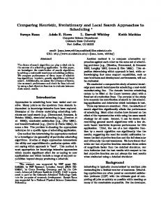
propose an evolutionary algorithm, i.e., a genetic algorithm (GA). Next, we propose a local search algorithm to adapt to the real conditions. The adaptation to real conditions requires a local search algorithm for several reasons. First, the problem is complex enough that brute force or other simple algorithms cannot solve it successfully. Second, the desire for a fast response necessitates algorithms that provide a good solution in a short period of time (such as local search algorithms). One important feature of the proposed deployment and subsequent tactical movements is that drones should form a connected mesh ad hoc network. A connected network means that there are no isolated drones and that every drone is reachable from every single other drone. This connectivity requirement exists because one of our main objectives is to provide Internet services to victims. To make this possible, the mesh network should use another long range communication technology (i.e., satellite communications). The idea is that one of the drones will be equipped with a satellite transceiver with Internet connection and it will share the Internet connection with the rest of the drones forming the network. Thus, in an unconnected mesh network, some drones would not be able to provide Internet services to victims in their locations. Figure 1 illustrates an example network deployment and communications that are possible with a set of drones in a disaster scenario. Figure 1 also shows how the drones form a mesh network (blue dotted lines) and how the drones provide communication services to the victims (red dotted lines).
UAV-to-UAV UAV-toOther
Figure 1. An Example of drones deployment and communications
It is important to highlight that this study differs from the direct application of the ad hoc paradigm in disaster scenarios [5]. We aim to deploy an alternative and dynamic communication infrastructure to which the victims can easily connect with their cellular phones in the same way that they connect to Wi-Fi spots at home or in public spaces. To reiterate this important feature: victims and 1st responders will access the network using common portable devices such as smartphones, tablets, etc. Thus, unlike the specialized mobile radios normally used by 1st responders, our proposed network is easy to access and provides widespread usability. Consider, for example, the TETRA (Terrestrial Trunked Radio) technology that is widely used in Europe [6]. TETRA terminals allow 1st responders to establish wireless communications; however, they lack interoperability with other ubiquitous free band wireless technologies like Wi-Fi and Bluetooth. There are no commercial smartphones with TETRA technology, therefore, it is impossible the exchange of information among 1st responders and possible victims. The main contributions of this study are:
3
An intelligent deployment of a dynamic mesh network in disaster scenarios that adapts to the real conditions, provides communication services, and searches for possible victims. A detailed evaluation of the proposed approach in disaster scenarios. We conduct extensive simulations to validate our approach under different conditions in a rural disaster scenario.
The paper continues as follows. Section 2 includes some relevant related work on two similar topics, such as the deployment problem and the mobility models for disaster scenarios. Section 3 presents the proposed approach and outlines the evolutionary and the local search algorithms used in our work. Section 4 presents and analyzes our simulation results. Finally, Section 5 concludes this paper.
2. Related work We divide the related work into two subsections. Section 2.1 reviews related works that address the deployment problem in disaster scenarios, while Section 2.2 is devoted to reviewing prior research on mobility models for disaster scenarios.
2.1.
Deployment problem
In this study, we propose the use of artificial intelligence based algorithms, such as evolutionary and local search algorithms, to address complex deployment problems. A thorough survey on the application of evolutionary algorithms in disaster scenarios can be found in [7]. Among the problems described in [7], the ones related to location are most pertinent to this paper. The location problems in disaster scenarios are focused on finding the best positions for fire stations, medical services, shelters, etc. These optimization problems are based on the study and analysis of the topography of a disaster area. The mentioned problems are related to the work presented in this paper, e.g., the deployed facilities should cover a large number of victims in a disaster scenario. In [8], the authors use genetic programming for search tasks of multiple UAVs. A team of UAVs is tasked with exhaustively covering a pre-defined search area, which is divided into target beacons, and then returning to a base location. This work is more focused on a military scenario, e. g., they consider that the drones can be destroyed due to hostile situations. The possible movements of a drone are defined as a decision tree, and genetic programming is used to determine the best moving strategy. The deployment problem of Wi-Fi wireless routers, using evolutionary algorithms, has already been studied in several works [9][10][11]. Our study, however, differs from the previous work for several reasons. First, the previous work does not consider that the Wi-Fi routers have to form a connected mesh network. Second, they assume that the Wi-Fi routers have to be placed in a grid, so the discrete search space is reduced in comparison to the continuous search space considered in this study. Third, in some studies, including [10][11], the authors do not limit the number of clients that a Wi-Fi router can serve simultaneously. In [12], the connectivity of crew-members acting in a disaster scenario is improved by the deployment of static auxiliary beacon nodes that are used as packet forwarders. The optimization problem is solved by applying a single objective genetic algorithm. In [12], the connectivity of the network is measured as the reachability achieved by broadcasting packets sent by the crew-members. The main issue of the solution proposed in [12] is that the authors
4
find the optimal positions of the auxiliary beacon offline. In addition, they only consider the connectivity among crew-members. Consequently, the victims are not modeled in [12]. In [13], an algorithm is proposed to solve the convex optimization problem of moving several robots towards a target point while maintaining the connectivity of the robots. Consequently, the wireless robots need to get closer to the destination, but without losing the wireless connectivity that exists. This is a reconfiguration problem, where robots should reconfigure themselves to reach the target destination. The authors propose both a centralized and distributed version of their algorithm. In [14], the authors present an algorithm to deploy wireless robots to connect a mobile user to a base station through a multi-hop communication path. The authors calculate the minimum number of wireless robots necessary to guarantee the shortest path between the mobile user and the base station. Their approach is based on equidistant separation of robots along the shortest path. In addition, the authors evaluate their approach considering obstacles in the communications among nodes. Our work stands out from previous work in this scientific area for several reasons. First, we consider that the information on the target scenario is limited. Second, the deployment of drones should guarantee that the drones form a connected mesh network. Third, we limit the number of clients that can be served by the same Wi-Fi router. Fourth, our proposed approach is not aimed at improving the performance of an ad hoc network; it is intended to improve the communication among the victims and the 0th responders. Fifth, the drones do not know the position of all victims during the adaptation to the real conditions phase; the drones only know a percentage of the victims’ positions in the initial deployment phase, which is denoted by K (described in more details later). Consequently, the problem presented in this paper is an exploration/search problem significantly different from the reconfiguration problem presented in [13].
2.2.
Mobility models for disaster scenarios
The mobility of 1st responders has already been modeled in [15], where the authors present the Disaster Area mobility model. The Disaster Area mobility model is based on a method called “separation of the room” [15][16]. In the Disaster Area mobility model, a disaster scenario is divided into different context-based areas. These areas are: incident site, casualty treatment area, transport zone, and technical operation command zone. One desired feature that does not exist in the Disaster Area mobility model proposed in [15] is the mobility of possible victims in the disaster area. In [17], the authors present CORPs: a synthetic mobility model for 1st responders. In this mobility model, attraction points, called attention events, are defined such that 1st responders move to these points. Unfortunately, the authors of [22] also do not consider the mobility of possible victims. In [18], the authors present the Human Behavior for Disaster Areas (HBDA) mobility model. It simulates the behavior of rescue teams performing search-for-victims operations. This behavior is represented by a set of algorithms that models a group of people scouting unexplored areas; the scouting people are distributed over the scenario while maintaining a line of sight with other members involved in the search operation. Another possibility is to use scenarios based on real maps and integrate the mobility of nodes restricted to those maps in a network simulator. This possibility is the basis for map-based mobility models. For example, in [18], the authors use a map-based mobility model with a map of the city of Loja in Spain. In [20], the authors propose a map-based mobility model for a Delay Tolerant Network (DTN) that considers the mobility of both rescue workers and victims. The 5
victims move towards evacuation centers whereas the rescue workers move towards the victims to supply relief food. With this map-based mobility model, we achieve a more accurate model of the disaster scenario; however, the mobility of nodes is still synthetically generated. This paper is not strictly about the design of a mobility model for drones in disaster scenarios. Our adaptation to the real conditions, however, means finding the optimal tactical movements of drones at the disaster scenario, which is a similar problem. Regarding the previous work in this field, this study takes into consideration both the victims and the crew-members. This feature is important since the movements of a rescue team should always depend on the positions and movements of the victims in the disaster scenario. The proposed approach also differs from previous path planning projects that are focused on finding optimal trajectories of drones in different target application areas [21].
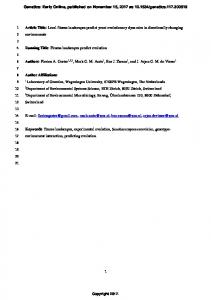
3. Our proposed approach: Evolutionary deployment and tactical movements based on local search The primary objective of the proposed approach is to provide communication to the maximum number of victims on the ground. The main assumption is that certain information about the disaster scenario, such as likely positions of victims, might exist. We define a target waypoint as a region where we prioritize coverage based on evidence of possible victims. Normally, a waypoint is defined by its GPS coordinates. Figure 2 shows the flowchart of our proposed approach. We divide the movements of 0th responders into two modes such as coverage mode and exploration mode (see Figure 2). On the one hand, in coverage mode, the objective is to place drones in the disaster scenario to provide the maximum communication coverage possible to victims. A victim is said to be covered when it is located at a Euclidean distance d shorter than or equal to r from a UAV. On the other hand, in exploration mode, the objective is to have the drones explore new areas in order to search for other possible victims. The starting point is the disaster event (see Figure 2). Then, drones are sent to the disaster area. While the drones are flying to the disaster area, in the headquarters of the first responders, they start collecting information about the disaster area. Such information can be collected from different sources, such as from using satellite images or phone calls made by people who saw the disaster. With this information, a first deployment of drones in the disaster area can be determined during the fly time. Using the information collected from the disaster prior to the arrival of the 0th responders, we define a knowledge level K, which is the percentage of known waypoints or victims. (More details on K exist in the simulation results in Section 4). Once the drones arrive at the disaster area, the initial deployment is carried out using the collected information (see Figure 2). In this case, drones work in coverage mode and are placed in the positions that guarantee the maximum possible coverage to the waypoints. The drones have to form a connected ad hoc mesh network, such that all drones are reachable from every other drone. For the initial deployment, we propose to use an evolutionary algorithm such as a Genetic Algorithm (GA). We note, however, that this initial deployment can be far from optimal due to the fact that we could only have partial information on the disaster scenario. Once the initial deployment is carried out, drones can obtain more accurate real time information and then use this info to adjust the initial deployment. Consequently, after the initial deployment, the drones start to work in a distributed way to explore new zones (adaptation to the real conditions in Figure 2). Drones will then adapt their positions according to the victims’ positions. In this phase of the proposed approach, where the drones work in exploration mode, the objective is to cover 6
unexplored areas to find new victims while maintaining the coverage to know victims. If a new victim is discovered, the positions of drones are updated to expand coverage to the newly found victims, while still maintaining a connected ad hoc mesh network and the coverage to know victims. This phase will end after a period of time and the drones will remain still providing communication services to the found victims on the ground. For this phase of the proposed approach, we propose to use a trajectory and local search algorithm such as a Hill Climbing Algorithm (HCA).
Figure 2. Flowchart of the proposed approach
7
It is important to highlight that our proposed approach works both in a centralized and distributed way. On the one hand, the global search algorithm used in the initial deployment has to be executed by a central unit with high computing resources. In general, evolutionary algorithms demand high computing resources since they need to complete many operations (evaluations of the fitness function) in order to deeply explore a significant part of the search space. On the other hand, the local search algorithm used in the adaptation to the real conditions uses only local information, i.e., nodes exchange information that is then used by the Hill Climbing Algorithm (HCA). For this reason, the HCA demands much less computing power than the genetic algorithm (GA). In our proposed communication infrastructure, the 0th responders form a multi-UAV network using ad hoc communications. Furthermore, the 0th responders function as access points for victims. It is important to note that victims will not connect to the mesh network using ad hoc mode. Instead, the victims will access the mesh network using normal mode, similar to how they connect to Wi-Fi in their regular lives. This feature is important because the ad hoc mode in the Wi-Fi transceivers in smartphones is limited. For example, in Android phones, the ad hoc mode only activates if the phone is in root mode, which is not the normal operation mode. Drones, on the other hand, are normally equipped with an embedded computer that can run an operating system such as Linux. Wi-Fi transceivers are easily configured in ad hoc mode within the Linux operating system. Furthermore, the proposed UAV-network can also cooperate with the existing communication infrastructure if not totally destroyed after the disaster event. Multi-hop communications are under study to improve last mile of cellular communications in the current 4G and the future 5G technologies. Therefore, micro cells can be deployed by using drones equipped with 4G and/or 5G transceivers [22], thereby increasing the capacity and coverage of the networks. Since the current UAVs have a limited battery lifetime of about an hour nowadays, the communication services that can be provided to the ground victims are also restricted in terms of duration and quality. Nevertheless, basic communication services, such as Internet access to download text information namely evacuation routes and maps, and chat applications with first responders can be easily developed on top of the UAV-mesh network. Furthermore, recently proposed replacement algorithms [23] can help to overcome the power battery limitations of current UAVs once the suitable positions of the UAV are known. Next, we describe in more details both phase of the proposed approach and give more information about the implementation of both meta-heuristics algorithms such as the GA and the HCA.
3.1.
Initial deployment
The initial deployment problem basically consists of finding the optimal positions of a number of drones working in coverage mode so that they can provide communication services to the target waypoints and surrounding areas.
3.1.1. Formal definition of the problem Given an array of target positions P, such that each element of the array is a tuple (x, y) that represents the Cartesian coordinates of a victim on the ground, and |P| = z, where z represents the number of victims and/or waypoints that need to be covered, the objective consists of
8
finding the most optimal positions (x, y)1 of I drones equipped with wireless transceivers that form a connected ad hoc mesh network to cover the maximum number of positions in P. A network or graph is connected iff there is a path between any pair of nodes. In our case, the nodes are drones. A drone i is connected to another drone or a victim j iff dij