FINE-RESOLUTION EROSION ESTIMATION ON LARGE SCALE BASED ON REMOTE SENSING DATA - AN APPROACH FOR TIBET AND CONNECTED REGIONS Mathias Leidig, Richard Gloaguen TU Bergakademie Freiberg, Institut of Geology Bernhard-v.-Cotta Str. 2, 09599 Freiberg, Germany email:
[email protected],
[email protected] 1. SUMMARY The aim of this project is to estimate and calculate the erosion based on interactions of the morphology with focus on precipitation as a climate factor in a very active area. In contrast to former attempts with GIS and ground based data this research focuses on calculations (using the Revised Universal Soil Loss Equation (RUSLE))based on remote sensing data as consequence of the large (entire Tibet) and hardly accessible territory. This study should make a contribution to recognize the correlation between climatic factors and soil erosion. 2. STUDY AREA AND MOTIVATION The Tibet Plateau includes the Himalayas, the whole Tibet Autonomous Region and occupies the main part of the QuinghaiTibet Plateau. Tibet and the Himalayas are among a tectonically very active area, where faulting and rock uplift are responsible for a rugged topography and a unique relief. It covers an area of about 5.5 million km2 and has an average altitude of 4500m. Further more, this area is a source of many rivers. The Tibet Plateau has a major influence on the environment and climate, not only of the region and Asia but also on global scale. Relief reflects the interplay between tectonics and erosion. The coupling of crustal deformation and erosion results in the kinematics of mountain building. Erosion influences tectonic processes by controlling boundary conditions at the Earth’s surface through denudation and deposition. Consequently erosion depends on climate and with this on precipitation, especially in a region where monsoon is active. Soil erosion sensitivity could be defined as a response of the regional environment to changes of impact factors like precipitation, soil texture, topography, vegetation and cultivation management. The complex interrelationship among all the components (natural factors and human activities), the large area with its unique geomorphological features and the lack of available long term data sets are an outstanding challenge for the investigation of the Tibet Plateau by modern remote sensing methods. 3. MAIN PURPOSE AND METHODS The main purpose of this project is to estimate and calculate the erosion based on interactions of the morphology with precipitation in a very active area. Compared to former attempts (eg. in Italy or Turkey)[1, 2] this study focuses on an area where no long term precipitation data are available and where precipitation differs a lot due to the relief and monsoon vs. non-monsoon time. In most studies uniform climate and with this uniform precipitation is considered, which remains doubtful when examing a large area like whole Tibet. Beside river profile analysis that appear to be a suitable method for erosion estimation in many different regions in the world, there is the need of erosion estimation on larger scales. The understanding of the spatial structure in precipitation regime shape (seasonal variability) and size (magnitude) may help to understand and estimate the amount of erosion also in extreme physical environments where climatological patterns are complex and consequently hardly known. Precipitation displays small-scale variability that requires frequent, closely spaced observations for an adequate representation. Such observations are not possible for whole globe when depending on surface based measurements. Consequently observations depend on a variety of satellites to estimate precipitation on a global basis. Data sets based on the Tropical Rainfall Measuring Mission (TRMM), which provide a calibration-based scheme for combining precipitation estimates from multiple satellites at fine scales (0.25o x0.25o 3-hourly) seem to fulfill all these requirements [3]. This approach is aimed at the estimation and (relative) calculation of erosion using SRTM (Shuttle Radar Topography Mission) and Landsat data in
combination with other different remote-sensing data obtained e.g. from the Tropical Rainfall Measuring Mission (TRMM) or the Moderate-resolution Imaging Spectroradiometer (MODIS) to solve the Revised Universal Soil Loss Equation (RUSLE). The equation for the Revised Universal Soil Loss can be written as: A = R · K · L · S · C · P, where A is the averaged quantity of soil erosion (t · ha−1 · y −1 ), R the precipitation erosivity (M J · mm · ha−1 · h−1 · y −1 ), K is the soil erodibility factor (t · ha · h · M J −1 · ha−1 · mm−1 ), LS is slope length and slope steepness factor, C and P are crop and erosion control practices factors. LS, C and P are dimensionless. One of the relevant characteristics and reason for applying the RUSLE model here is that all the main factors, which influence soil processes, can be evaluated accurately. In addition to that, it is possible to replace missing detailed data with reliable estimates. Further more it is applicable with surfaces of varying extension, from a small plot to large scales [2]. Due to a population density of about 2.08 people· km−2 the conservation practice factor P can be set as 1. The remaining equation for sensitivity of soil erosion (SSE) can be expressed as: SSE ∝ R · K · L · S · C
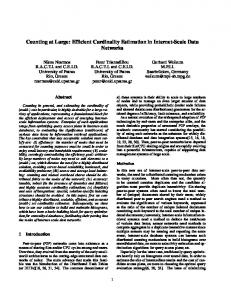
Corresponding parameter
TRMM
R
Soil
Soil Map (FAO) + ESA
K
Topography
Digital Elevation Model, SRTM
LS
Vegetation/ Land Cover
NDVI, SAVI, LAI (Landsat + MODIS)
C
Precipitation
Integrated estimation of erosion/ erosion sensitivity
Data Basis
Natural Factor
Estimation map for each factor
The whole procedure is summarized in Figure 1. This project has a two-folds outcome. First to understand the relationships between mountain and plateau building with climatic factors and erosion better, but also to produce a precise erosion risk map for the whole region.
Fig. 1. Soil erosion sensitivity/ calculation scheme
4. REFERENCES [1] Filippo Onori, Piero De Bonis, and Sergio Grauso, “Soil erosion prediction at the basin scale using the revised universal soil loss equation (rusle) in a catchment of sicily (southern italy),” Springer-Verlag, p. published online, 2006. [2] Ahmet Irvem, Faith Topaloglu, and Veli Uygur, “Estimating spatial distribution of soil loss over seyhan river basin in turkey,” Journal of Hydrology, , no. 336, pp. 30–37, 2007. [3] George J. Huffmann, Robert F. Adler, David T. Bolvin, Guojun Gu, Eric J. Nelkin, Kenneth P. Bowman, Yang Hong, Erich F. Stocker, and David B. Wolf, “The trmm multisatellite precipitation analysis (tmpa): Quasi-global, multiyear, combined-sensor precipitation estimates at fine scales,” Journal of Hydrometeorology, vol. 8, pp. 38–55, 2007.