Apr 18, 2003 - ute database SILP (Information System of State Forests) and digital forest maps. (LMN), as ... tral scanner AISA for revision and updating of the digital forest map and SILP data- base of ...... Vol.13 B. Fotogrametria bli- skiego i ...
© EARSeL & Warsaw University, Warsaw 2005. Imaging Speclroscopy New quaMy'" enwronmenfa) slutfes Zagajewski 8.. SobczaK M . (eds)
FOREST MAP REVISION USING THE HYPERSPECTRAL SCANNER AISA IMAGES
Wezyk Piotr \ Bogdan 2 Agricultural University of Cracow, Faculty of Forestry, Department of Forest Ecology, Laboratory of CIS and Remote Sensing, Cracow, Poland, rlwezyk(g)cvf-kr.edu-pl Agricultural University of Cracow, Faculty of Forestry, Department of Forest Protection and Climatology, Cracow, Poland, vasus(o)interia-pl
ABSTRACT Taking decisions in the Polish State Forests is supported by the using of the attribute database SILP (Information System of State Forests) and digital forest maps (LMN), as well as by generation of selected thematic maps. The hyperspectral images are a rich source of the objective, precise, and quickly available information about the forest. A complex nature of the forest ecosystem requires usage of images containing not only geometrical (shape, size, coordinates) information, but also about spectral characteristics of single forest stands. The purpose of this study was to determine the usefulness of a high resolution (1 x 1 m; 32 channels) hyperspectral scanner AISA for revision and updating of the digital forest map and SILP database of Niepolomice Forest near Krakow {southern Poland). AISA images proved highly useful in identification of coniferous and broadleaf stands, and also of non-forest areas (grass vegetation). It was possible on their basis to delineate the homogeneous parts of the image, which are a basic requirement for creating and verifying a forest division into compartments. It was also possible to determine some stand characteristics, such as: the crown cover density or stand mixture (cluster, belt etc). The integration of airborne scanners images in to the GIS, and their practical use for new forest management plans give the opportunity to support the inventory field work or forest monitoring.
INTRODUCTION A rational management of forest resources, expressed in the first place by their balanced utilization and care to increase their biodiversity, requires a deliberate administration in space and time. In Europe since 19 the century forest management provides information being the basis for creation of specific rules, instructions, and management plans for the forest areas. In Poland at the present time the methods of forest inventory are defined by the Instruction of Forest Management (i), which also defines various kinds of forest maps {understood as the visualization of the management plan §1. pnt 15), The generating and use of thematic maps require functioning of the system GIS based on the updated bases of geometrical and attribute data connected by relations. In Poland, forests make about 28.4 % of the country's area, i.e. almost 8.9 million ha (ii), and 80 % of them is under ownership of the State Forest - National Forest Holding. In respect of administration the forest area is divided into 17 Regions, each administered by the Regional Directorate of State Forests, The Regions are divided into Forest Districts (430 in total), and in each forest district there are several Forest Ranges (about 5000 in total).
£) EARSeL 8 Warsaw University Warsaw 2005 Imaging Spedroscnpy. We» quality in environmental studies Zagajewski B Sobczak M.. (eds)
Since 1977 the Information System of State Forests (SILP) has been functioning in all forest districts. One of its modules is the database ,,LAS" storing the attribute data obtained during forest inventory (every 10 years). Work on implementation of the digital forest maps (LMN) in Polish State Forests was initiated in the 1990s, while the technical assumptions of their generating i.e. a so called Standard of Digital Forest Map (SLMN) were defined by the Regulation No 74 of 23 August 2001. It has defined in detail the standard of map generating at the level of a forest district and implementation of the GIS. It was modified by the next Regulation No 43 of 18 April 2003. At the present moment 167 forest districts (about 40 %) are furnished with digital forest maps, and other 104 will receive them soon, thus in 2005 almost 63 % of area of Polish State Forests will be managed on the basis of LMN. A subcompartment (forest stand) is the basic structural entity of the spatial subdivision of Polish State Forests, having under the Information System of State Forests, a unique for whole Poland, primary key called the "forest address". It is a combination coded in form of a string of characters, like: Regional Directorate, Forest District, Working Circle, Forest Range, compartment, and subcompartment (e.g. 17-133-13-64-b-OO). The basic criteria for separation of the forest survey units are: the need of a different silvicultural treatment and the necessity of securing the proper accuracy of inventory in the case of diversification of taxation characters (i). The subcompartments are formed from the forest survey units assuming the principle that for forest lands they must be at least 0.01 ha in area. In some cases the area must be greater than 0.10 ha (e.g. forest nurseries, timber landings, parkings), or greater than 0.50 ha (tree plantations, cutting areas, clearings). Remote sensing provide information concerning spatial and (multi-) temporal distribution of forest complex. Combinig the 2D (spatial location XY) and temporal (time factor) data enables the assesment of the status of forest ecosystem and occured changes. The use of aerial photographs in forestry has increased during the last several decades along with propagation of Color Infra Red films, digital photogrammetric stations and facilitations in generating of aerial ortophotomaps or appearance of airborne digital cameras (iii, iv, v, vi). The integration of photogrammetric workouts with other technologies, such as LiDAR (vii),GPS, or GIS (viii) is applied not only in the forest inventory research (ix) but also in forestry practice. Technologies of imaging the earth's surface (EO) yielding the satellite images have been used since long ago in forestry to determine the forest type, forest mixture, and biomass as well (x, xi, xii, xiii, xiv). The revision and updating of forest maps may also be connected with development of object classification (ix) which creates new possibilities in a semi-automatic or fully automatic methods of forest stand mapping based on multi- and hyperspectral airborne and satellite (e.g. IKONOS, QuickBird, Orbview) images as well as aerial photos (xv, xvi, xvii, xviii, xix). Thanks to a continuous progress in technology, the airborne scanners (e.g. AISA, HyMap, CASI, AVIRIS, Daedalus, etc.) with resolution of several dozen or several hundred spectral channels, reach a high ground resolution, and their practical use in forestry ever increases (xx, xxi, xxii). Hyperspectral airborne imagery might be used for detecting and mapping of single tree stress, like insect infestations (xxiii) or fungous diseases (xxiv) and for the health monitoring of large forest areas (xxv) and sustainability as well (xxvi). Also the mapping of the different types of vegetation and soil may be accomplished on the basis of the classification of hyperspectra! images (xxvii). The main purpose of this study was to demonstrate the usefulness of the hyperspectral scanner AISA (Airborne Imaging Spectrometer for Applications; Specim) in the process of revision and updating of the digital forest maps (LMN) generated on the basis of geometrical and attribute databases used in Polish State Forests.
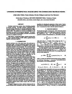
METHODS Test site The Niepolomice Forest (southern Poland), a remnant of the great primeval forest lowland (Fig.1), located close to Cracow, was chosen as a test site for this study. 1
0
1
2
3
4
5 Kilometers
Legend: Test comparments AISA images available
Fig. 1. Location of analyzed compartments in the Niepolomice Forest District The Niepolomice Forest (RDLP Krakow) of 10 512 ha in area, is composed of two main parts. The southern "main complex" (about 8 500 ha) is generally composed of coniferous and mixed forest (Pino-Quercetum) and the northern complex (about 1.850 ha) is dominated by natural deciduous forest stands (Tiiio-Carpinetum). The tree species in the Niepolomice Forest, especially in its southern "main complex" has been distinctly changed by man resulting in prevalence of coniferous species introduced to sites proper for broadleaf tree species. The present species composition of the Niepolomice Forest stands is as follows: Scots pine (66 %), oaks (19.3 %), and black alder (10.6 %). Due to the occurrence of mixed stands (PinoQuercetum) in the Niepolomice Forest, and its compact complex, as well as numerous investigations carried out in the past, this area has been selected as one of the three nodes of the FOREMMS (Forest Environmental Monitoring and Management System 5FP EU 1ST 1999-2002). One of the main objectives of the FOREMMS project was to create an information system about forests of Europe, working on several levels (L1, L2, and L3). The task of AISA was to supply information to databases of the most detailed ievei L1 along with information coming from the terrestrial forest inventory. Field work The AISA images, originating from flight of the research aircraft SC7 SkyVan (HUT) over the east part of the Niepolomice Forest (Fig. 1) on 13 Aug 2001 within FOREMMS were used in this study. The AISA scanner may register waves of range 430-900 mm divided into maximum 288 channels, 1.6 to 9.4 mm wide. During the 639
iscopy. New quality in environmental studies. Zagajewski B , Sobczak M., teds)
flight AISA registered radiation in 32 separated spectral channels of dedicated width fixed in order to correlate the values of reflection with concentration of selected photosynthetic pigments. At flight altitude of 1000 m and speed of 50 m/s the ground resolution of images of 1rn x 1m was obtained (xx). The position of the aircraft was determined on the basis of the read-outs of the DGPS (Boening) receiver and the system INS. To create a developed interpretation key (training areas) and the maximum likelihood classification of AISA images, the area network of FOREMMS monitoring plots was used, and additional training and test areas (ROI) were established using DGPS measurement (xxviii) and applying a GPS Pathfinder PRO XRS (Trimble) receivers and reference station in Cracow (Trimble). Laboratory work In utilized GIS analyses and revision of the attribute and geometrical databases, the digital forest map and revelant descriptive base of the Information System of State Forests (created in 2001 as the result of forest inventory), made available by the Niepolomice Forest District (Krakow Regional Directorate) were used. During the work, the ENVI software (maximum likelihood classification) and ER Mapper (georeferencing, ECW compression) were used. Due to large illumination differences during the flight (effect of clouds) the updating of digital forest map was carried out separately for selected test compartments, free from geometrical distortions and situated in the same flight strip. For this purpose 10 forest compartments, of different internal variability (number and shape of subcompartments) numbered: 32, 52, 71, 75, 156, 158, 183, 425, 432, and 461 were selected for this study (Fig. 1). To determine usefulness of AISA images in the process of revision and updating of the digital forest map, two methods were used (Variants I and II) differing in the degree of interference in the existing spatial forest subdivision. •
Variant I - a method of interpretation and screen vectorization of the AISA image. The correction of subcompartment (forest stand) delineation was made only on the basis of observation of AISA images (composition of RGB channels numbered: 25 (790nm), 16 (673nm), and 10 (555nm). No changes of the number of subcompartments was made (no new ones were created), and only the revision and updating of boundaries existing within tested compartments were carried out.
•
Variant II - A combined method based on the maximum likelihood classification of the AISA image, and also on the existing attribute SILP database and digital forest maps. In the maximum likelihood classification based on the training areas selected during creation of the interpretation key and establishment of 186 FOREMMS areas, all 32 available spectral channels were used (xxii). In this method the updating or removing of existing subcompartments, and creation of new ones take place. In the case when stands differed slightly in age and other forest taxation characters, the subcompartments were united if classification showed similar results.
Taxation characters In addition, in the Variant II (a combined method) the possibility of determination by AISA images of selected taxation characters of stands, including the actual production area (understood as the area of a vertical projection of crowns on a horizontal surface) was tested. This area was determined for individual subcompartments in per cent, on the basis of image classification, as the sum of classes making the stands.
© EARSeL a Warsaw Universily, Warsaw 2005 Imaging Spectroscopy. New quality in environmental slMlies. Zagajewski B.. Sobczak M., (eds)
The designation of image pixels fulfilling the criteria of forest inventory was tested qualifying them to: Gaps - treeless areas in stands older than 20 years, but not designated for final cutting, over 0.02 ha in size. •
Clusters - their volume must be registered in the SILP system, and as in the case of openings and clumps, their location must be defined. However, the Instruction of Forest Management (§ 28 pnt 7) orders in the case of these objects, not forming subcompartments, to measure their contours (shape) directly on the ground or use for this purpose the aerial photographs or satellite images.
Delimiting of the gaps, openings, and clusters was carried out automatically on the result of classification of the AISA image using a logical query to the geometrical database. The selection of the following objects was carried out: •
Gaps - compact fragments over 0.02 ha in area classified as the class ,,Shadow";
•
Openings - compact fragments over 0.02 ha in area classified as the class ,,Grass", inside a surrounding stand, and
•
Clusters - compact fragments over 0.02 ha in area classified as a stand not formed by the dominant tree species in a given subcompartment.
RESULTS The AISA images supplied by HUT were burdened with errors resulting from technical problems of power supply of the DGPS system, and this caused interruptions in reading of the scanner position (WGS84). Therefore the errors in determination of the position affected the correctness of mosaicking of several dozen flight strips and also the image calibration. Thanks to the additional calibration based on 15 GCP evenly distributed within the entire mosaic, the average geometric accuracy (RMS error) of about 4 meters was attained. To compare the accuracy to the quality of forest map we have to notice that the 1mm of on the analogue forest map (printed) in scale 1:10.000 mean 10 meter in the forest. The taxation description of stands recorded in the database of the Information System of State Forests showed large divergences between the file (record/ Field value) and their actual area (geometry in shape file). For the test compartments this error varied from 3 % to over 14 %. The actual (not a file} area of subcompartments, generated from the shape file, was taken as the reference point for the analysis of the AISA image. It is very difficult to present the results of analyses carried out in Variants I and IE using per cent changes (in the area as well as in the length of spatial subdivision lines). Probably the most correct way would be utilization for this purpose of the method of indexes which are frequently used in the description of changing elements of landscape (e.g. indexes of changes in area of subcompartments, their number, and object shape). The results of testing the respective methods of updating and revision of digital forest maps (Variants I and II) are shown below, using compartment No 183 as an example (Fig. 2).
£> EARSeL S Warsaw University. Warsaw 2005. Imaging Spec/roscopy. New Qua/iiy In environmental sluities. Zagajewski B.. Sobczak M.. (edst
Test compartment 183
(I)
Fig. 2. The actual state (reference) and the result of application of Variants I and II of updating for forest compartment No 183. Using the method of Variant I, on the basis of a visual interpretation of the RGB composition shown on the screen, the correction of subcompartment boundaries was made adjusting it to the actual situation in the compartment. In the compartment No183, corrections concerned all of 11 existing subcornpartments. The differences in relation to the existing digital forest map were mainly revealed in the course of boundaries of subcornpartments ,,i" (- 21 %) and J" (+ 34 %), and also in decreased area of subcompartment ,,d" (- 24 %) in favour of adjacent subcornpartments ,,g" and ,j". On the basis of the Variant II a new definition of the course of subcompartment boundaries was made using at the same time information from the attribute database of the Information System of State Forests and results of the maximum likelihood classification of the image. The correctness of attributing the pixel classes to the proper object classes for the tested compartment No 183 was 88.5 % on the average. In this compartment for example subcornpartments ,,g" and ,,j" (almost pure pine stands, 105-110 years old) were joined with each other, as well as the subcompartments ,,d" and ,,h" (wet area overgrown with alder of poor reforestation success together with grasses and sedges). At the same time the boundaries of subcompartments: ,,b" (considerably smaller area actually covered with pine sapling stand), ,,i" (stand with high percentage of pine), J" (pine stand with oak and alder admixture), and ,,k" (alder stand) were considerably altered. The new subdivision only little altered the boundaries of subcompartments: ,,a" (beech stand) and ,,c" (pine stand 90 years old) confirming their correct location and description in the existing database of the Information System of State Forests. The determination of the actual production area for individual subcompartments in compartment No 183 showed the lowest value for subcompartment ,,f", and this was confirmed by field work. There is a young alder stand of low reforestation success which should be reforested again. While the highest value of production area was found for subcompartment ,,b" - a very dense pine sapling stand.
692
Detailed characteristics of changes in Subcompartment area in all test compartments, defined in two Variants (I and II) of revision and updating of digital forest maps are shown below (Table 1).
71
Reference [ha]
Subcompartment
Reference [ha]
a
2,22
1,63
(-27)
0,67
(-70)
f
10,92
b c
1.00
1.16
(+17)
1,03
(+3)
g
3.37
2.98
2.61
(-13)
1,53
(-49)
h
n.e.
1,41
(+6)
CD
en
•— '
1
I
I 1.
d
1.33
1.26
(-5)
f
3,68
4.79
(+30)
7.83 (+11 3)
g
2,10
1.10
(-48)
1,06
(-49)
h
4,98
6.87
(+38)
5,22
i
1.90
2.54
(+34)
4.84
(-27)
0
Compartment
Subcompartment
Compartment
Table 1. Results of revision and updating of digital forest maps on the basis of Variant I and II. The per cent change in relation to existing area subdivision is in parenthesis. The following abbreviations are used: .e. - not exist, del-removed, new newly created.
ro •—-
m '—'
1 I
11,11 3,86
(+2)
n.e.
n.e.
n.e.
1,28
(new)
n.e.
n.e.
0,58
(new)
k I
n.e.
n.e.
1,66
(new)
(+5)
n.e.
n.e.
0,67
(new)
(del)
m
n.e.
n.e.
0,44
(new)
(+8)
n
n.e.
n.e.
1,86
(new)
a
8,21
b
4,36
n.e.
a
10,49
8,20
b
2,83
3,65
(+29)
4,10 (+45)
c
0,77
1.00
(+30)
1,04 (+35)
d
3,02
4.05
(+34)
0
f
0.56
0,51
(-10)
0,59
g
0,11
0,23 (+107)
0
h
4,27
4.39
(+3)
i
1,29
1.04
(-20)
i
1.19
1,46
(+23)
1,36 (+15)
c
3,04
k
n.e.
n.e.
0,30 (new)
d
0,79
[
n.e.
n.e.
1,59 (new)
f
4,13
3,83
(-7)
n.e.
0,33 (new)
0,96 (new)
10,24
(del) (new)
i
6.62
(-22)
0 1,12
j
156
i
7,11
15,11 (+38)
(+15)
k
n.e.
i i.
(-2)
c
4,13
d
13,57
(del)
f
(+6)
(del)
4,38
(+3)
a
1.89
0,59
(-54)
b
4,39
158
10,19 (+24)
8,05
(-2)
(-62)
3,01
(-31) (-17)
1,67 4,51
(+9)
3,44
13,9
(+3)
14,23
n.e.
n.e.
0,52
g
n.e.
n.e.
0,74
(new)
h
n.e.
n.e.
0,30
(new)
2,01
(+7)
2,03
(+8)
4,41
(+1)
1,78
(-60)
3,24
(+7)
3,14
(+3)
0,60
(-24)
m
n.e.
g
3,64
4,25
(+17)
a
2,94
4.53
(+54)
2,92
(-1)
h
3,09
3,34
(+8)
b
6,66
3,74
(-44)
6,17
(-7)
i
7,07
5,61
(-21)
c
1,36
1,76
(+30)
0
(del)
i
2,14
1,88
(-12)
d
0,72
0,93
(+30)
0
(del)
k
1,01
0.89
(-12)
f
4,03
3.93
(-3)
1,39
(-66)
g
3,92
4.40
(+12)
1,69
(-57)
h
2.57
2.91
(+13)
2,70
i i
2.68
2.22
(-17)
1,72
4,71
5,15
k
n.e.
I
n.e.
183
(+5)
(new)
0
(del)
10, 78 (+161) 5,98
0 4,51
0
(+64) (del) (-36) (del)
0,64
(-37)
I
3,35
4.48
(+34)
5,68
(+70)
a
11,34
10,45
(-8)
5,31
(-53)
(+5)
b
0,43
0,53
(+23)
0
(del)
(-36)
c
2,45
2,03
(-17)
1 ,93
(-21 )
(+9)
5,36 (+14)
d
0,26
0.57 (+116)
n.e.
1,44 (new)
f
0,64
0,56
(-12)
n.e.
2,26 (new)
g
1,97
1,51
(-23)
425
0,52
0 2,98
(+96) (del) (+51)
693
e EARSeL 8 Warsaw University. Warsaw 2005. Imaging Spectiuscopy New qualify in etii/aonmetXal studies Zagajewski B., Sobczak M., (eils)
75
156
m
n.e.
n.e.
0,89 (new)
h
3,65
n
n.e.
n.e.
0,81 (new)
i
4,26
0
n.e.
n.e.
0,89 (new)
a
3,32
P r
n.e.
n.e.
0,50 (new)
b
5.02
n.e.
0,83 (new)
a b
3,03
2,80
(-8)
2,98
(-2)
4,66
3,56
(-24)
3,24
c
4,37
4.44
(+2)
4,11
d f
4,59
4,83
(+5)
11.41
12,43
(+9)
n.e.
n.e.
n.e.
4.75
(-12)
(+8)
3,77
2,80
(-16)
3,33
(+0)
4.33
(-14)
4,25
(-15)
2,85 (+53)
c
1,87
3,01
(+61)
d
1,15
0,90
(-21)
0
(-30)
f
12,45
12,78
(+3)
12,53
(+1)
(-6)
g
1,45
1,44
(-1)
1,51
(+4)
n.e.
0,79
(new)
432
h
n.e.
(+9)
a
6,02
5,88
(-2)
0,22 (new)
b
13,87
12,32
(-11)
5,08 (+11)
12,43
10. 50 (+187)
(+30)
4,61
9 a
5,31
5,80
(+9)
4,53
(-15)
b
3,75
3,03
(-19)
1,29
(-66)
c
4,17
3.43
(-18)
1,76
d
4,20
4,50
(+7)
0
(del)
(del)
21,74 (+57)
c
3.03
4,66
(+54)
0
1,81
1,99
(+10)
2,20
(-58)
d f
1,29
1,18
(-8)
1,90
(+47)
1,43 (-66)
g
n.e
n.e.
0,19
(new)
461
(del) (+21)
The application of the Variant II caused revision of existing subcompartments and undertaking of the decision about a new area subdivision. The changes in numbers of compartments are shown below {Table 2). Table 2. Changes in numbers of compartments according to the new area subdivision (Variant II). Number of subcompartments Forest compartment
Variant II
Reference (LMN 2001) Updated
New created
8
1
32
9
52
9
7
3
71
9
7
7
75
5
5
1
156
6
5
7
158
4
4
3
183
11
8
0
425
8
6
0
432
6
5
1
461
5
3
1
The maximum likelihood classification of the AISA image permitted to create the classes representing gaps and openings in the stand. Additional clusters of trees (result of classification) were tested from the point of view of fulfilling the conditions defined in the Instruction of Forest Management (i). Also the size of the actual production area of subcompartments was determined using compartment No 183 as an example (Fig. 3).
7 t-^ScL 5 Warsaw University, Wa
Zagaiewski B , Sobczak M , feds]
Selected taxation characters of stands in test compartment 183
sub compartment
Legend: HEE Pine - less than 21 years old |0 Pine - more than 100 years old -5£» Oak - moie than 100 years old -*?&& Alder - less than 21 years old HH Alder - between 21 and 100 years old Beech - between 21 and 100 years old Meadow HI Shadow Percent of actual production area indicated in parenthesis
Fig. 3. Selected taxation characters of stands in the test compartment 183.
CONCLUSIONS Frequently forest maps used in Polish State Forests are burdened with errors. The causes of such a situation should be looked for in the process of their generation on the basis of archival analog maps. The quality of these maps has not been verified until now on the basis of aerial photographs, ortophotomaps, and an image of the airborne scanner or the DGPS measurement. The annex No 8 to the standard of a digital forest map {xxix} stresses that ,,the basis of application of the digital forest map as a GIS element is its actuality..." and that the updating of a geometric base must be carried out parallel to changes made in the attribute base of the Information System of State Forests, A lack of the unmistakable definition of the term ..regularity" causes problems for forest district employees who must make updating by themselves. Special programs for these tasks have been worked out, such as ,,UPDATER" or ..Digital forest map check-up" (xxx), checking up the quality of the digital forest maps obtained from their executors. This study confirmed that the ground resolution of AISA pixel (1 x 1 m) is fully sufficient for updating and revision of boundaries of area subdivision. It is possible to distinguish on the image the homogeneous fragments (stand/compartment) as well as single crowns of trees in older age classes (especially of broadleaf trees). Using the combined method (Variant II) for revision and updating of stand boundaries makes the elimination of errors in forest maps (geometric) and records in attribute databases possible. In order to fully utilize the potential of the high-resolution hyperspectral AISA images a proper carrying out of the flight (light conditions uniform for the entire area) as well as of the process of mosaicking and georeferencing the image (measurement GPS and INS) must be secured. The errors due to wrong mosaicking of the image considerably limit the usefulness of AISA image in maximum likelihood classification (xxii). High-resolution AISA images are a very rich source of information about the forest ecosystem. Their utilization makes the correction and current updating of existing
© EARSeL & Warsaw University, Warsaw 2005. Imaging Speclroscopy New quality in environmental studies ZagajewsKi B., Soticiah M., (eds)
area subdivision possible. The results of this study indicated that using information contained in only three properly chosen spectral channels (Variant I of updating) gives the user the possibility of correction of the existing subdivision in agreement with actual state. The maximum likelihood classification of the AISA image, applied in Variant II, permits to take into account all of the information stored in 32 spectral channels during updating of digital forest maps. The result of updating based on image classification is undoubtedly affected by a carefully defined training areas (ROI) chosen on the basis of the interpretation key, as well as the image preprocessing, i.e. their proper georeferencing, and finally mosaicking. The maximum likelihood classification AISA carried out showed a high accuracy in identification of species of coniferous and broadleaf trees and other non-forest objects. It is also the basis for an automatic distinguishing of additional elements of forest taxation of defined descriptive attributes (e.g. species, age) and spatial ones (e.g. area, geographic coordinates) such as gaps and openings by SQL queries to the geometic database created within the classification (conversion of raster to vector). The Instruction of Forest Management (i) allows the obtaining information about geometry of objects on the basis of aerial photographs or by VHR satellite data, and this opens the possibility of utilization of airborne hyperspectral scanners in forest inventory. Other legal basis, i.e. Annex No 2 to the standard of digital forest maps (xxix) confirms this possibility since it states that „ admissible are (...) satellite images of ground pixel resolution not greater than 6 x 6 m...." (Pnt 2.2.2.2). At the present time the aerial ortophotomaps, also covering forest areas, are made for the system IACS-LPIS using ED founds. But they mostly use B&W aerial photos in scale 1:13.000 (xxxi), and therefore they are not too useful for forest inventory. A VHR IKONOS satellite images, characterized by the size of the ground pixel close to that of the AISA scanner (1 x 1 m PAN) have been made for the frontier areas of Poland. The IKONOS, however, registers only 4 spectral channels, which means smaller possibilities in classification and interpretation in comparison with AISA images. Therefore the AISA images would successfully serve for a cyclic updating of digital forest maps (geometry) and updating the attribute databases. It is of a particular importance in situation when the State Forest Holding charters every year many aircrafts or helicopters to inspect forest fire hazard. The hyperspectral scanner AISA could therefore be easily implemented as a forest monitoring tool securing high quality information about the forest ecosystem at relatively small financial expenditures as this has been suggested in several financial projects of the Polish State Forests (xxxii). The development of technology of object oriented classification and utilization of rich information stored in many spectral channels creates a hope for the prompt utilization of semi- or fully automatic methods of image processing (xxxiii) for updating of databases (geometric and attribute) used in the Polish State Forest.
ACKNOWLEDGEMENTS We would like to thank the team of the Laboratory of Space Technology, Technical University of Helsinki (HUT), the partner in the project FOREMMS IST-1999-11228, for making the AISA images accessible, and also the Niepolomice Forest District (Krakow Regional Directorate) for giving permission to use digital forest maps (LMN) and attribute databases of the Information System of State Forests (module LAS).
References i
PGL LP 2003. Instrukcja Urza^dzania Lasu. Czesc 1. Instrukcja sporzqdzania planu urzajdzania lasu d!a nadlesnictwa. Zatqcznik do Zarzqdzenia nr 43 DGLP z dn. 18.04.2003.
ii
PGL LP 2003a. The State Forest National Holding. Annual Report 2003.
iii
Armenakis C., Regan A. 1996: Map revision using digital ortophotos. International Archives of Photogrammetry and Remote Sensing, Vol. XXXI, Part B4. Commission IV, ISPRS, Wien.
iv
Agouris P., Stefanidis A. 1996; Integration of photogrammetric and geographic databases. International Archives of Photogrammetry and Remote Sensing, Vol. XXXI, Part B4, Commission IV, ISPRS, Wien.
v
Mayr W., Reinhardt W. 1996: Digital Photogrammetry join GiS - A Powerful Combination. International Archives of Photogrammetry and Remote Sensing, Vol. XXXI, Part B4, Commission IV, iSPRS, Wien.
vi
Pekkarinen, A., Sarvi, V. 2002. Detection of clearcuttings with help of high-altitude panchromatic aerial photographs and image segmentation. In: Operational Tools in Forestry using Remote Sensing Techniques. ForestSAT Symposium. Edinburgh, Scotland, August 5th-9th 2002.CD-ROM.
vi!
Diedershagen, O., Koch, B.T Weinacker, H., Schutt, C. 2003. Combining Lidar- and GIS data for the extraction of forest inventory parameters. In: ScandLaser Scientific Workshop on Airborne Laser Scanning of Forests. Umea, Sweden, ral Sciences, Department of Forest Resource Management and Geomatics. Working paper 112. 273 p.
viii
Wezyk P., Guzik M., 2004: The use of ,,Photogrammetry-GIS" (P-GIS) for the analysis of changes in the Tatra Mountains' natural environment. In: A message from the Tatra. Geographical Information Systems and Remote Sensing in Mountain Environmental Research. Krakow, Poland, Riverside, California, USA, pp. 31-46.
ix
Wezyk P., de Kok R., Zajaczkowski G.t 2004. The role of statistical and structural texture analysis in VHR image analysis for forest applications. A case study on Quickbird data in the Miepolomice Forest. In: Angewandte Geoinformatik 2004. Herbert Wichmann Verlag. Heidelberg, p. 770-775.
x
Haapanen, R., Ek, A.R., Bauer, M.E., Finley, A.O., 2004. Delineation of forest/nonforest land use classes using nearest neighbor methods. Remote Sensing of Environment 89: 265-271.
xi
Nilsson, M., Rosengren, M., Aalto, P. , Kennedy, P., 2002. Simultaneous use of Landsat TM and 1RS-1C WiFS data in estimating large area tree stem volume and aboveground biomass. Remote Sensing of Environment 82: 156-171.
xii
Franco-Lopez, H., Ek, A.R. & Bauer, M.E. 2001. Estimation and mapping of forest stand density, volume, and cover type using the k-nearest neighbour method. Remote Sensing of Environment 77: 251-274.
xiii
Ma'kela, H. & Pekkarinen. A. 2001. Estimation of timber volume at the sample plot level by means of image segmentation and Landsat TM imagery. Remote Sensing of Environment 77(1}: 66-75.
xiv
Kias U., Franz H., Lotz A., 2004: Working towards a standard for RS-based classification of landcover and biotope mapping in the alpine space. In: A message from the Tatra. Geographical Information Systems and Remote Sensing in Mountain Environmental Research. Krakow, Poland. Riverside, California, USA, pp. 183-192.
697
©EARSeL & Warsaw University. Warsaw 20D5 Imaging Spectroscopy. New qualify in environmental studies Zagajewski B.. Sobczak M., (eds)
xv
Martin M.E., Newman S.D., Aber J-D., Congalton R.G., 1998. Determining forest species composition using high spectral resolution remote sensing data. Remote Sens. Environ. 65:249-254.
xvi
Burnett, C. and Blaschke, T. 2003. A multi-scale segmentation/object relationship modeling methodology for landscape analysis. Ecological modelling 168: 233-249.
xvii
Pekkarinen, A. 2002. A method for the segmentation of very high spatial resolution images of forested landscapes. International Journal of Remote Sensing 23(14): 28172836.
xviii Pekkarinen, A., Tuominen, S. 2003. Stratification of a forest area for multi-source forest inventory by means of aerial photographs and image segmentation. In: Advances in Forest Inventory for Sustainable Forest Management and Biodiversity Monitoring. Forestry Sciences. Vol. 76: 111-124. Kluwer Academic Publishers, Dordrecht, Netherlands. xix
Meinander, M., Rantasuo, M., Okkonen, J,, Aikio, M., Sipola, K., Pylkkd, P., Braam, B. (eds.), 1993. Airborne Imaging Spectrometer for Applications (AISA). 1993 International Geoscience and Remote Sensing Symposium (IGARSS'93). Tokyo, Japan, pp 479-481.
XX
Makisara K., Meinander M., Rantasuo M., 1993. Airborne Imaging Spectrometer for Applications (AISA). Proceedings of the International Geoscience and Remote Sensing Symposium (IGARSS'93), pp. 479-481, Tokyo. Japan.
xxi
Holopainen, M. 1998. Forest habitat mapping by means of digitized aerial photographs and multispectral airbone measurements. University of Helsinki, Department of Forest Resource Management. Publications 18: 1-49.
xxii
Wezyk P., Wertz B., Waloszek A., 2003: Skaner hiperspektralny AISA (airborne imaging spectrometer for applications) jako narzedzie pozyskiwania informacji o ekosystemie lesnym. Archiwum Fotogrametrii, Kartografii i Teiedetekcji. Vol.13 B. Fotogrametria bliskiego i dalekiego zasi^gu. p.477-496.
xxiii Lawrence R., Labus M. 2003. Early Detection of Douglas-Fir Beetle Infestation with Subcanopy Resolution Hyperspectral Imagery. Western Journal of Applied Forestry, July 2003, vol. 18, no. 3, pp. 202-206(5). xxiv Kankaanhuhta, V., Makisara, K., Tomppo, E., Piri, T., Kaitera, J, 2000. Monitoring of diseases caused by Heterobasidion annosum and Peridermium pini in Norway spruce and Scots pine stands by airborne imaging spectrometry (AISA). In: Ukonmaanaho, L. & Raitio, H. (eds.). Forest condition monitoring in Finland - National report 1999. Metsantutkimuslaitoksen tiedonantoja 782: 113-131. xxv
Tomppo, E., Pekkarinen, A., Kankaanhuhta, V., Makisara, K., Henttonen, H. 1999. Airborne imaging spectrometer (AISA) in forest inventory and forest health monitoring. In: Raitio, H. & Kifponen, T. (eds.). Forest condition monitoring in Finland. National report 1998. Metsantutkimuslaitoksen tiedonantoja 743: 140-147.
xxvi Treitz P.; Howarth P. 1999. Hyperspectral remote sensing for estimating biophysical parameters of forest ecosystems. Progress in Physical Geography.Vol. 23 (3), Hodder Arnold Journals, pp. 359-390(32). xxvii Torma, Markus, Heikki Rainio and Timo Ruohomaki (2002). Classification of vegetation and soil using AISA-spectrometer: some results from Lammi test area. The Photogrammetric Journal of Finland, pp. 73-84. xxviii
Wezyk P. 2004. GPS in forestry: myths and facts. Annafs of Geomatics. Vol. II, Number 4. Polish Association for Spatial Information. Warsaw, p.19-32.
xxix Zarzadzenie nr 74 Dyrektora Generalnego Lasow Pahstwowych z dnia 23 sierpnia 2001 r. w sprawie zdefiniowania standardu lesnej mapy numerycznej dla poziomu nadlesnic-
twa oraz wdrazariia Systemu Informacji Przestrzennej w nadlesnictwach (IP-0411114/01). xxx
Smoliriski R,, Plutecki W-, 2004. Aktualizator LMN - program do aktualizacji lesnych map numerycznych. Roczniki Geomatyki. Systemy Informacji Przestrzennej w Lasach Paiistwowych. Tom 2. Zeszyt 4. PTIP. Warszawa.
xxxi Preuss R, Kurczyiiski Z., 2002. Koncepcja wytworzenia ortofotomapy dla potrzeb systemu identyfikacji dziatek rolnych - LPIS. Geodeta , Nr 8 (87). xxxii Zajaczkowski G., Wezyk P., 2004. Remote Sennsing Technoiques in Forest Inventory. Annals of Geomatics. Vol. II, Number 4. Polish Association for Spatial Information. Warsaw. p.41-50. xxxiii
Pekkarinen, Anssi. 2004. Image segmentation in multi-source forest inventoryFinnish Forest Research Institute. Research papers 926. ISBN-951-40-1929-6.