Forest monitoring using all archived Landsat data F. Thonfeld1 & G. Menz1,2 1
Center for Remote Sensing of Land Surfaces (ZFL), University of Bonn, Walter-Flex-Str. 3, D-53113 Bonn 2 Remote Sensing Research Group (RSRG), University of Bonn, Meckenheimer Allee 166, D-53115 Bonn Contact:
[email protected], +49-(0)228-734975, www.zfl.uni-bonn.de
Study site
Data
Background Forest monitoring is essential for the assessment of CO2 exchange rates, biomass estimation, forest health assessment & forest management. Bi-temporal methods do not reveal spatiotemporal processes. Annual data time series allow for the assessment of trends. However, some challenges arise: a) data have to be selected carefully – in many cases cloud-free data sets are rarely available; b) Landsat 7 ETM+ SLC-off data are useless in this case. c) the season of forest harvesting & withinseason dynamics cannot be detected; Why not using all data from the USGS archive? Here, we show a way to make use of it.
Time series from April 1984 (launch of Landsat 5 TM) to end of 2012 1550 scenes from Landsat 5 TM and Landsat 7 ETM+ (path 047/048, row 026; Fig. 1) Number of scenes per year varies between 23 (1989: only summer acquisitions, one sensor) and 91 (2004: all possible acquisitions, two sensors) Fewest scenes of December (sum=101), most scenes of August (sum=152) About ¼ of all scenes have 100% cloud / cloud shadow cover 113 scenes have 5% cloud / cloud shadow cover or less (half of them between Jul & Sep; Fig. 2) The proposed method takes advantage of all images irrespective of percent cloud cover (Fig. 3).
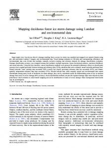
Fig. 1: Study site on Vancouver Island. The test site is located in the overlapping part of p047r026 and p048r026 and is 30x30km². The background shows the SRTM DEM indicating hilly terrain up to 1100m in the test site.
Fig. 2: Temporal distribution of scenes with less than 5% cloud & cloud shadow. Note: there are years without any score.
Fig. 3: Cloud & cloud shadow coverage of all scenes. Green colors indicate “good” scenes. In the proposed method all scenes with less than 100% cloud & cloud shadow are usefull.
Southern Vancouver Island, BC, Canada Large forest stands dominated by Douglas-fir, western red cedar & Sitka spruce Temperate climate (the mildest of Canada) with average temperature of 4°C in January and 18°C in July (Victoria) Precipitation varies extremely between western part (up to >6500mm) and eastern rain shadow regions (about 640mm) Temperate rain forest along the west coast
Methods & workflow All data were pre-processed according to the workflow in Fig. 4 Key steps comprise cloud masking using Fmask, conversion of DN to surface reflectance using LEDAPS, and relative radiometric normalization using IR-MAD Spatial distribution of clear land pixels is shown in Fig. 5 Several indices were calculated – to be comparable with Modis data, NDVI was first used and is shown here Breaks were detected as follows: a) Constructing an individual time series for each pixel b) Filtering the time series using a Savitzky-Golay filter with different windows sizes (Savitzky & Golay 1964; Fig. 6) c) Calculating median time series from filtered profiles d) Calculating first deriviate of filtered time series e) Selecting the smallest value as threshold Masking results based on max-min-difference of each pixel, Fmask output and NDVI threshold 0
Fig. 4: Workflow to detect abrupt changes in index time series (NDVI & DI).
43%
Fig. 5: Clear land pixels as percentage of all valid pixels. It is obvious that the east coast of Vancouver Island has most observations.
Results & Outlook Abrupt changes are well detected irrespective of available number of observations (Fig. 7). Note: for 2012 only Landsat 7 ETM+ data are available; however, clearcuts could be derived Filtering is required with the presented time series
Challenges remain for those areas that have been harvested before the observation period. Further analysis will include DI Clear cut characteristics & statistics over time will be derived.
570
0,89
281
0,03
2012 2011 2010 2009 2008 2007 2006 2005 2004 2003 2002 2001 2000 1999 1998 1997 1996 1995 1994 1993 1992 1991 1990 1989 1988 1987 1986 1985 1984
Fig. 7: Number of clear land pixels as percentage of all valid pixels (left), difference of max and min values of each pixel (mid), and years of clear cuttting (right). The clear dut date could be detected irrespective of the number of observations.
References Fig. 6: NDVI time series of a single pixel with an strong change in autumn 2004 overlain by filtered time series using Savitzky-Golay filtering with different window sizes. Best fit is achieved with smaller windows (e.g. 11).
Acknowledgment We thank J. Masek for providing the LEDAPS code, Z. Zhu & C. Woodcock for the provision of the Fmask code, M. Canty for the IR-MAD code and USGS for opening the Landsat archive in 2008.
Canty, M. J. & A. A. Nielsen (2008): Automatic Radiometric Normalization of Multitemporal Satellite Imagery with the Iteratively Reweighted MAD Transformation. Remote Sensing of Environment 112 (3): 1025–1036. Healey, S. P., W. B. Cohen, Y. Zhiqiang & O. N. Krankina (2005): Comparison of Tasseled Cap-based Landsat data structures for use in forest disturbance detection. Remote Sensing of Environment 97, 301-210. Masek, J. G., E. F. Vermote, N. E. Saleous, R. Wolfe, F. G. Hall, K. F. Huemmrich, F. Gao, J. Kutler & T.-K. Lim (2006): A Landsat Surface Reflectance Dataset for North America, 1990-2000. IEEE Geoscience and Remote Sensing Letters 3 (1): 68–72. Savitzky, A. & M. J. E. Golay (1964): Smoothing and differentiation of data by simplified least squares procedures. Analytical Chemistry, 36, 1627-1639. Tucker, C. J. (1979): Red and Photographic Infrared Linear Combinations for Monitoring Vegetation. RSE 8 (2): 127–150. Zhu, Z. & C. E. Woodcock (2012): Object-based Cloud and Cloud Shadow Detection in Landsat Imagery. RSE 118: 83–94.