Functional Requirements for a Comprehensive Transportation Location Referencing System
By Teresa M. Adams Associate Professor Department of Civil and Environmental Engineering University of Wisconsin-Madison 2208 Engineering Hall, 1415 Engineering Drive Madison, WI 53706 Voice (608) 262-5318, Fax (608) 262-5199 Email:
[email protected] Nicholas Koncz Research Assistant Department of Civil and Environmental Engineering University of Wisconsin-Madison 2205 Engineering Hall, 1415 Engineering Drive Madison, WI 53706 Voice (608) 236-4103 Email:
[email protected] Alan P. Vonderohe Professor Department of Civil and Environmental Engineering University of Wisconsin-Madison 1204 Engineering Hall, 1415 Engineering Drive Madison, WI 53706 Voice (608) 262-9854, Fax (608) 262-5199 Email:
[email protected] June 2000 Submitted for publication in the Proceedings of the North American Travel Monitoring Exhibition and Conference
Adams, Koncz and Vonderohe
2
Functional Requirements for a Comprehensive Transportation Location Referencing System Teresa M. Adams, Nicholas Koncz and Alan P. Vonderohe University of Wisconsin-Madison, Madison, WI 53706 ABSTRACT Transportation agencies manage data that is referenced in one, two, three, and four dimensions. Location referencing system (LRS) data models vary across transportation agencies and often within organizations as well. This has resulted in failed attempts and abandoned efforts to interoperate business functions and / or integrate data. A number of transportation agencies, through recognition of the significance of spatially-referenced information to their operations, have identified the need for comprehensive management of location referencing. What is lacking is a clear set of functional requirements for a comprehensive location referencing system. Detailed functional requirements and a comprehensive data model are necessary so transportation agencies can implement improved transportation information systems and advanced GIS-T technology. Linearly-referenced data constitutes the majority of data managed by transportation agencies. However, agencies are now using GPS technology for applications ranging from highway inventory to incident management. Much more detail is needed on functional requirements for data in higher dimensions and for integration across dimensions. This paper reviews the functional requirements for a comprehensive spatial / temporal referencing system that were identified by a workshop of stakeholders in asset management, highway operations, traffic management, and transit. Among the requirements identified by the stakeholders is that a comprehensive LRS data model supports temporal referencing. Temporal aspects of transportation data impact applications ranging from pavement management (for historical records) to transit (for arrival times), to commercial vehicle operations (for vehicle tracking), to congestion management (for dynamic network modeling).
Adams, Koncz and Vonderohe
3
INTRODUCTION A number of transportation agencies, through recognition of the significance of spatiallyreferenced information to their operations, have recently developed internal policies and standards with regard to the management of location referencing. A location referencing method (LRM) is a “way to identify a specific location with respect to a known point.” A location referencing system (LRS) is “a set of office and field procedures that include a highway location reference method” (1). The focus of state DOTs is changing from planning-designing-building then rebuilding facilities to managing the entire life-cycle of facilities. Consequently, the emerging data needs of DOTs not only include facility inventory and condition assessment but also real-time data to support ITS, incident management, and driver information systems. Existing LRSs at the state and local levels are almost exclusively linear and highway or street oriented. The changing role and focus of DOTs, metropolitan planning organizations (MPOs), and transit agencies - and emergence of Global Positioning System (GPS) and other spatial technologies - are driving the need for a location referencing system that can accommodate and integrate data expressed in one to four dimensions. In fact, transportation agencies already manage data that is referenced in one, two, three, and four dimensions. However, these data are usually managed in incompatible ways and with technologies and databases that cannot be integrated due in part to the lack of clear functional requirements for a comprehensive location referencing system. The requirements for a comprehensive location referencing system data model encompass all the elements and abstractions for the multidimensional representation of events and objects. The data model must be able to represent objects and events in the form or dimension in which they occur in the real world, whether it be one-dimensional (e.g. guard rail), two-dimensional (e.g. a parking lot), or three-dimensional (e.g. an interchange). Additionally, without the incorporation of the fourth dimension (time), much of the data collected, analyzed, and reported become useless because all real-world objects are referenced by their state in time. An object may be permanent, but its characteristics change with time and, therefore, the object evolves with time. Since all objects and events are defined by the temporal element, excluding it would provide limited functionality and representation of stakeholder processes. A comprehensive
Adams, Koncz and Vonderohe
4
transportation LRS must be enterprise-wide and facilitate the representation of a spectrum of business functions/processes/applications for transportation agencies from the local level to the federal level. These applications can range from pavement management (for historical records) to transit (for arrival times), to commercial vehicle operations (for vehicle tracking), to congestion management (for dynamic network modeling). Some examples of time-based analyses include: • Queries and analyses that evaluate historical trends; • Modeling of future events; • Identification of events that fall within a given time period; and • Aggregation of event that occur over time and distance into a single event, such as a car chase with intermittent incidents. WHAT IS A FUNCTIONAL REQUIREMENT? One of the first steps in developing a comprehensive transportation LRS is to identify the system’s functional requirements (i.e., what it is intended to do). Functional requirements lead to data requirements (i.e., the information needed to perform the desired functions) (2). According to Martin (3), “a functional requirement is a functional-level capability or business rule which is necessary to solve a problem or achieve an objective.” NCHRP 20-27(3) WORKSHOP The primary objectives of the NCHRP 20-27(3) Workshop on Functional Specifications for Multimodal, Multidimensional Transportation Location Referencing Systems held in Washington DC on December 3-5, 1998 were to identify and define functional requirements that must be supported by a comprehensive transportation LRS data model. The scope of the NCHRP 20-27(3) research is roadway transportation (all modes) and four dimensions (three spatial, one temporal). Workshop participants were organized into four stakeholder groups for discussion. Those stakeholder groups were: •
Group 1. Transportation Planning, Highway Construction, and Asset Management
•
Group 2: Highway Safety and Incident Management
•
Group 3: Traffic Management and Highway Operation
•
Group 4. Transit Facilities and Operation; Commercial Vehicles and Fleet Management
Adams, Koncz and Vonderohe
5
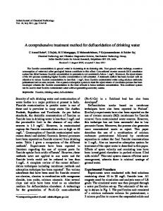
CORE FUNCTIONAL REQUIREMENTS From the NCHRP 20-27(3) workshop ten core functional requirements were derived. These core functional requirements form the essence of a data model required to accommodate a comprehensive transportation location referencing system. Each of the ten core functional requirements are stated and discussed in this paper. Functional Requirement I: Spatial / Temporal Referencing Methods A comprehensive location referencing system data model supports the locate, place and position processes for objects and events in three dimensions and time relative to the roadway. A comprehensive LRS supports multiple alternative spatial / temporal referencing methods. The locations of objects and events in a multidimensional transportation system can be expressed in a variety of spatial / temporal methods, such as coordinates, civic addresses, or linear referencing as shown in Figure 1. Time is defined as “A system for measuring duration” (4). Time can be observed as being discrete (represented by timestamps or intervals) or continuous, absolute/relative, or cyclic (5). In actuality, location does not exist without time, so both are necessary to provide a reference. If the location of an object is known, then the time(s) of its occurrence can be found, and the reverse is true.
AVL/GPS
(-111.888, 40.6993, 4,197.821) 3330 S State SSLC
Address Street Route/Milepost Intersection/Offset
Bus Route/Offset Bus Route/ Time
A0089 372.753 3300 S & State (S) +210 ft Rt 120 +4.992 mi (08:50 trip)
9:14 (Rt 120 08:50 trip)
FIGURE 1 Multiple Spatial / Temporal Referencing Methods.
Adams, Koncz and Vonderohe
6
NCRHP 20-27(2) identified four functional requirements of a location referencing system in the linear data domain: “locate”, “position”, “place” and “transform” (6). “Locate” means to establish the location of a point in the field in relation to another object. "Position" means to define a real-world location in a database, and "place" means to convert the database description into a real-world location. “Transform” means to convert location references made in one method to another. The NCHRP 20-27(2) requirements dealt with locations in space. The participants of the NCHRP 20-27(3) workshop expanded the four functional requirements of NCHRP 20-27(2) to include locations in both space and time. Functional Requirement II: Temporal Referencing System / Temporal Datum A comprehensive location referencing system data model accommodates a temporal datum that relates the database representation to the real world and provides the domain for transformations among temporal referencing methods. The most common temporal referencing system is Greenwich time, which is based on a temporal referencing datum – Coordinated Universal Time (Gregorian Calendar). All temporal referencing methods can be related to Coordinated Universal Time. Local temporal referencing methods, such as zonal time, are tied to Coordinated Universal Time through calibration and consistency of measurement (i.e., a minute is the same measurement across all methods). One can argue an analogy between a linear location referencing system of multiple linear referencing methods (e.g. milepost-offset) and a temporal referencing system (TRS) of multiple temporal referencing methods. Since movement in time is restricted to one dimension that is uni- or bi-directional, many of the components of a linear LRS are applicable to a TRS. Temporal references can be relative to a universal origin (e.g., 0 A.D.), analogous to route-milepoint spatial references (e.g., Rt 12 MP 2.1). Alternatively, temporal references can be relative to local reference points (e.g., the day before yesterday), analogous to route-reference-point spatial references (e.g., I-93 RP 200 + 100’). Local temporal references can be transformed into universal temporal references if we know the universal reference of the local reference point (e.g., today’s date). Events in time can be instantaneous, analogous to spatial point events. In addition, events in time can have durations with beginnings and ends, analogous to linear spatial events.
Adams, Koncz and Vonderohe
7
Functional Requirement III: Transformation of Data Sets A comprehensive location referencing system data model supports transformation between linear, nonlinear and temporal referencing methods without loss of spatial / temporal accuracy, precision, and resolution. Conversion or transformation of the spatial / temporal locations from on method to another is fundamental to the utility of a comprehensive location referencing system data model. Issues such as the accuracy, resolution and source of data sets and individual objects become critical in that they provide limits on the results of the transformation process. There are several categories of the transformation of data sets. The first transformation category is purely spatially, with time being a constant. This category includes the transformation from a linear location referencing method (LLRM) to another LLRM (addressed by NCHRP 20-27(2)), the transformation from a LLRM to or from a 2D or 3D location referencing method (LRM), and transformation among 2D or 3D LRMs. The second transformation category involves converting an LRM address at a specific time to the equivalent LRM address at a different time. For example to find the route-post-offset in 1990 of the location that is now Route 30 Post 15 Offset 10. This spatial / temporal transformation allows for historical analysis and data integration. The third category of transformation involves converting from a LRM to a TRM (Figure 2). For each transformation category, the transformation between LLRM, LRM and TRM should be accomplished without loss of information and with an error not greater than that inherent in the source methods. Functional Requirement IV: Multiple Cartographic / Spatial Topological Representations A comprehensive location referencing system data model supports multiple cartographic and topological representations at both the same and varying levels of generalization of transportation objects. An object or event can be represented cartographically as a point, line, or area. The choice of cartographic representation is usually made to be consistent with the degree of generalization or scale of the map. For example, a bridge can be a point, a line, or an area based upon the
Adams, Koncz and Vonderohe
8
displayed scale. Or that bridge can be a line when introduced into a one-dimensional system regardless of scale. Within current GIS models, an object or event has one topological representation, a node, link or polygon. Generalization algorithms can change the object's cartographic representation but the topological representation remains constant. To facilitate multidimensional spatial operations in transportation applications, the data model needs to support topological aliases of an object. Some examples include pedestrian involved incidents (point events) within a parking lot (area feature) or the “overlay” of an area incident onto a linear network. A robust data model allows for multiple cartographic and topologic representations of an object and provides linkages between representations so that changes in representations due to map scale or level of generalization lead to references to the appropriate cartographic or topologic representation. Functional Requirement V: Resolution A comprehensive location referencing system data model supports the display and analysis of objects and events at multiple spatial and temporal resolutions. Resolution defines the detail of data. Resolution can be expressed in terms of the number of significant digits for the source, display, and analysis of data. For example, mileposts can be recorded and displayed in 0.1, 0.01, 0.001 of a mile. The resolution of displayed data is often scale dependent. Level-of-detail requirements give rise to thresholds not only of scale but also of representation in higher dimensions. For example, incidents can be represented as spatial point events along a centerline for general analysis (e.g. safety management), at the lane level or as a multidimensional representation for detailed analysis (e.g. incident management). The considerations for spatial resolution are also applicable to temporal aspects of transportation data (7). For example, the time of occurrence of a crash can be measured to the nearest month for seasonal analysis, to the nearest twelve hours for diurnal analysis, or to the nearest fifteen minutes for analysis of lighting conditions at dusk or dawn.
Adams, Koncz and Vonderohe
9
Functional Requirement VI: Dynamics A comprehensive location referencing system data model supports the navigation of objects, in near real-time and contingent upon various criteria, along a traversal in a transportation network. With the emergence of ITS and the new focus of state transportation agencies on operations, the functionality of navigation is relevant (8). The incorporation of time within the model provides for this functionality. Traversal guidance – being able to provide directions from an origin to one or more destinations as a function of select criteria - is a key function particularly for the stakeholders in Group 3. Inclusion of navigation requires a conveyance object (usually a vehicle or a person) that moves within the spatial / temporal reference frame. True traversal guidance incorporates infrastructure elements (e.g., clearances, road closures), traffic-related elements (congestion during peak hours), demographic elements (schools, hospitals), and path restrictions, as well as pedestrian barriers (e.g., handicap access). Traversal guidance is not just providing the shortest path under ideal conditions and according to static criteria (e.g., shortest distance, lowest adjacent population, fewest railroad grade crossings). Traversals should have the ability to be modified in response to dynamic conditions that change en-route. Therefore, the model must support data from different sources and a robust set of guidance functions. Functional Requirement VII: Historical Databases A comprehensive location referencing system data model supports regeneration of object and network states over time, and maintains the network event history. Typically within a GIS database, the temporal element is categorized as an attribute of the object being represented. Often due to the lack of temporal operators within a GIS and the lack of adequate and accurate temporal data, the time attribute is not fully utilized or included. The presence of this attribute may be questioned in very large databases. In addition, many stakeholders duplicate non-spatial data (e.g., accident reports) in relational databases that can perform temporal analyses (e.g. Oracle). All objects are defined by their state in time. Events change the states of objects. For example, an event might cause the creation of new objects or retirement of existing objects. With the
Adams, Koncz and Vonderohe
10
incorporation of time within a data model, various historical analyses can be performed, such as comparing the states of an object over time, or displaying the system state (map plus attributes) that most closely matches the controlling record time. Functional Requirement VIII: Accuracy and Error Propagation A comprehensive location referencing system data model supports association of error measures with spatial / temporal data at the object-level and propagation of those errors through analytical processes. The location references for transportation features often are collected, analyzed, operated on, transformed, and compared without regard for positional accuracy and other quality aspects of the data. Positional and temporal errors, arising from imperfect measurements, are inherent in the data. Furthermore, certain operations on data, such as projection between dimensions (e.g. from GPS to a LLRS), can introduce additional persistent spatial distortions. Errors propagate through spatial / temporal analytical processes that manipulate data in various ways to produce results used in decision making applications. These applications overlay, combine, and compare data having various precisions, accuracies, and resolutions. The characterization, propagation, and visualization of errors in transportation data are not well managed, leaving decision-makers to face unknown risks of reaching flawed conclusions and erroneous decisions arising from uncertainty and lack of quality measures. Functional Requirement IX: Object-Level Metadata A comprehensive location referencing system data model stores and expresses object-level metadata to guide general data use. In GIS models, metadata (“data about data”) provides information on the origin of the data within a classification level (e.g., coverages, themes, layers, tables). The accuracy or error of the data can be indirectly derived from the origin of the data source (e.g., for TIGER DLG, data errors could be ± 100 m). Problems arise in many cases where there are multiple sources for the data in a level each with an error at a confidence interval. Therefore, metadata needs to exist for a specific feature or object including an error measurement to guide use and representation of objects.
Adams, Koncz and Vonderohe
11
Functional Requirement X: Temporal Topology / Latency A comprehensive location referencing system data model supports temporal relationships among objects and events and the latency of events. Since all objects are defined by their state in time and events are actions that happen instantaneously in a point of time and change the state of objects (9), temporal relationships exist among objects and events, producing a temporal topology. Topological relationships can include disjoint, overlap, during, and simultaneous. The temporal topological relationships may be explicit or derivable from temporal coordinates. Temporal topology allows for the following operations: •
Spatial / temporal proximity – e.g., prevent road striping before paving.
•
Temporal within – e.g., identify all projects being let in the third quarter of the year.
•
Spatial / temporal within – e.g., find all accidents during a construction project within a construction boundary.
•
Temporal after – e.g., find all accidents that occurred after a project completion.
In transportation applications, latency is often associated with the difference in time between scheduled and actual events occurring at a particular location in space. An example is the difference in the actual time a bus arrives at a bus stop versus the scheduled time the bus was to arrive. The concept of latency can also be applied to the problem of database updates. A database update, or knowledge of an event, always occurs after the event has taken place. CONCLUSIONS Functional requirements are the basis for the development of a detailed data model. A data model, as defined by Date is “... a standard way of describing data requirements as a set of entities – things we want to know about and include in the information system – and the relationships between them” (10). The functional requirements are clearly driven by technology. The stakeholders want to take full advantage of current and emerging technological capabilities in their work processes. Each of the requirements can be traced back to a recognized potential use of technology that is limited by the current representation of data. Stakeholders want to use the capabilities of current GIS software to integrate and visualize data in new ways. Stakeholders want to exploit the convenience of GPS for data collection. Stakeholders want to use existing data sets to support
Adams, Koncz and Vonderohe
12
new applications such as for ITS. The stakeholders require support for temporal topology and geometry. The stakeholders want smart data or a model that makes data smart. They want data to know its alternative dimensional, cartographic, topological, and historical representations. Furthermore, data should know how to deal with its own source and how to deal with its own limitations arising from resolution, accuracy and error propagation. The functional requirements are model independent, however we cannot ignore existing data models that address various requirements. In building a comprehensive LRS data model it is important to balance requirements and to build upon the existing knowledge base. ACKNOWLEDGEMENT This work was sponsored by the American Association of State Highway and Transportation Officials, in cooperation with the Federal Highway Administration, and was conducted in the National Cooperative Highway Research Program, which is administered by the Transportation Research Board of the National Research Council. REFERENCES (1) Baker, W. and W. Blessing. Highway Linear Reference Methods, Synthesis of Highway Practice 21. National Cooperative Highway Research Program. National Academy Press. Washington, D.C., 1974. (2) Ensor, D. and I. Stevenson. Oracle Design, O’Reilly & Assoc., 1997. (3) Martin, J. Information Engineering, Book II: Planning and Analysis. Prentice-Hall, Inc. Englewood Cliffs, NJ, 1990. (4) Webster. Webster's New World Dictionary, Second College Edition. William Collins + World Publishing Co., Inc. New York, 1974. (5) Worboys, M.F. GIS: A Computing Perspective. Taylor & Francis, London, 1995. (6) Vonderohe, A.P., Chou, C.L., Sun, F., and T.M. Adams. A Generic Data Model for Linear Referencing Systems. Research Results Digest 218. National Cooperative Highway Research Program. Transportation Research Board, Washington, D.C., 1997.
Adams, Koncz and Vonderohe
13
(7) O’Neill, W. “Space and Time from an ITS Perspective”. Presentation at AASHTO GIS-T Symposium. April 1998. (8) Fletcher, D. and C. Dean, (1996). “Navigating in a Digital Object Habitat.” In Proceedings, Conference on Object Orientation and Navigable Databases. NCGIA Report 96-9, 1996. (9) Rumbaugh, J., Blaha, M., Premerlani, W., Eddy, F., and W. Lorensen. Object-oriented Modeling and Design. Prentice-Hall, Inc. Englewood Cliffs, NJ, 1991. (10) Date, C. J. An Introduction to Database Systems. Addison Wesley Publishing Co., Inc. 1990.