and monitoring tools, network facilities to transmit filed data, etc. ... Probability of High Alert = Probability of high severity, in case, event happen à Probability for ...
IOSR Journal of Applied Geology and Geophysics (IOSR-JAGG) e-ISSN: 2321–0990, p-ISSN: 2321–0982.Volume 3, Issue 3 Ver. I (May - Jun. 2015), PP 13-16 www.iosrjournals.org
GIS and Sensor Based Monitoring and Prediction of Landslides with Landslide Monitoring and Prediction System (LMPS) for Indian Scenario Murugesh Prabhu T.S., Sivakumar V., Binay Kumar, Biju C. and Pinak Ranade Spatial Sciences and Disaster Management Group, Centre for Development of Advanced Computing (C-DAC), Pune University Campus, Pune – 411007
Abstract: Monsoon rains affect the Indian subcontinent every year causing devastating floods and deadly landslides. The worst damages usually are reported in the northern and north-eastern part of India in the Himalayan region. High risk landslide sites are located across the country, which become dangerous during rainy season. Hence, monitoring and prediction of landslides in these regions are of utmost importance. Geographical data management and dissemination for mitigation activities in the event of such disasters can be handled effectively using GIS technology and physical sensors. With parallel computing power available, models can be run by varying parameters to simulate different landslide scenarios. This will help in understanding the landslide precursors, critical parameter values and create awareness among those living on these slopes on real time. Application to the whole regional territory over a dense computation grid can aim at the development of a real time system to generate landslide risk scenarios based on precursor data. The proposed Landslide Monitoring and Prediction System (LMPS) is based on the principles of landslide physics and hence a sensor-based monitoring of the precursor variables will lead to an operational landslide monitoring and prediction system, combining the strengths of mathematical modeling and GIS.
I.
Introduction
Landslide, that is a downward and outward movement of slope forming material in response to the force of gravity, occurs when shear resistance of slope forming mass is exceeded by shear stress (Brunsden, 1993; Hampton, et al, 1996). Landslides may be initiated by factors like geological, hydrological, topographic climate,man induced, etc. In India, annual losses on account of managing with natural disasters, accumulates to 20% of its GDP. A cursory survey of frequency of occurrence of landslides in Sikkim was done in 1991 and result clearly documented that the East and South District, where, Daling rocks dominate, are affected by maximum number of landslides (NIC, 1991). The Daling Group of rocks, especially, Goribathan Formation appears more prone to landslides than the inhomogeneous quaternary deposits and gneisses and schist of Higher Himalaya. The high landslide susceptibility of the Daling Group of rocks has been attributed to their severe shear distortion owing to loading and unloading during or genesis, higher rate of weathering and mineral composition (SSDMA, 2007). Hilly terrain including the eastern Himalaya has suffered extensively with landslides primarily triggered by loosening of soil during roads and construction activity (SAARC, 2010). As landslides may cause huge loss of lives and properties, there is a need to formulate strategies for minimizing the societal impact of landslides (NIDM, 2012).
II.
Mathematical modeling of Geo-hazards
Physical models are based on mathematical operators (including empirical methods), which take into consideration some physical parameters, like soil thickness, pore pressure, etc (SM, 1981). They compute quantities like residual strength and shear on the soil layers. Various empirical methods have been tried and tested by scientists for various regions around the world (Haugenand Kaynia, 2008), but a system for India demands for unique requirements in terms of elevation data availability, security concerns, advanced mapping and monitoring tools, network facilities to transmit filed data, etc. With parallel computing power available, models can be run by varying parameters to simulate different landslide scenarios. This will help in understanding the landslide precursors, critical parameter values and create awareness among those living on these slopes.
DOI: 10.9790/0990-03311316
www.iosrjournals.org
13 | Page
GIS and Sensor Based Monitoring and Prediction of Landslides with Landslide Monitoring …. III.
Simulating a 3D Landslide model
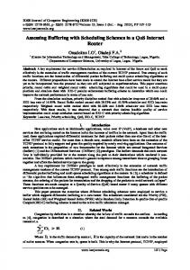
A 3-dimensional slope-stability model can be used (Fredlund, 2011; Lam, 1993). Factors like slope angle, soil depth, soil strength, and depth of ground water are considered in this model. The degree of landslide hazard is expressed in terms of the factor of safety F, which is the ratio of the forces that prevent a slope from failing over those that try to make a slope fail Factor of Safety (F) = Resisting Force / Driving Force. Probabilistic framework will be developed for risk estimation, which is described in the equation 1. Probability of High Alert = Probability of high severity, in case, event happen × Probability for the event to happen ……….. (1) i.e., L (A) = L (A/B) L (B) Where, L (A) expresses the level of alert, L (A/B) expresses the severity of the event, given that it happens, and L (B) expresses the probability of the event to happen The empirical landslide model is calibrated so as to represent the behavior of pilot study area. The generic landslide model works on a balance between the parameters representing the slip-mass‟s weight and the resistance forces countering gravity. As rain water percolates into the soil, it fills the pores resulting in porepressure increase which is measured by the “Pore Water Pressure Sensor” (Rosanno, et al., 2010). A sharp increase in pore water pressure is usually observed before the occurrence of a landslide. This trend needs to be correlated with the strain gauge readings to detect precursors, such as formation of the “slip surface” (Terzis, et al., 2006). The “slip surface” is characterized from the deformation readings from the strain gauges as shown below (Fig.1): High risk landslide sites are located across the whole regional territory. Application to the whole regional territory over a dense computation grid can aimed at the development of a real time landslide risk scenario. Moreover, GIS-based modeling techniques can be applied in order to build a physically-based system capable to improve the overall performances, taking in account rainfall, soil moisture, geometric, hydrologic and mechanical characteristic of the slopes etc. A linear relation between the rainfall thresholds and the initial soil moisture conditions are to be derived from satellite.
Fig. 1.Slip surface characteristics
IV.
Proposed Landslide Monitoring and Prediction System (LMPS)
In the proposed system, a pilot area is selected; information with its latitude, longitude, prominent feature nearby, aspect, area etc are taken into account. Geology of the area indicates prevailing sub surface conditions such as rock type folds and faults etc. The altitude becomes an important parameter in differentiating its variations. Climatic condition plays an important role in understanding the land use land cover of the area which draws the inference the extent or category of the landslide. The past history of the landslides its occurrences and scale aids to the accuracy of the prediction. High resolution satellite imagery along with the good quality elevation data becomes a necessity for implementing the Landslide Monitoring and Prediction System (LMPS). DOI: 10.9790/0990-03311316
www.iosrjournals.org
14 | Page
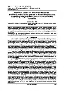
GIS and Sensor Based Monitoring and Prediction of Landslides with Landslide Monitoring …. The pilot area is selected based on the landslide hazard zone map and the area that is highly susceptible to landslides. Rainfall data is collected from the Weather Monitoring System, which also provides a probable rainfall predicted based on numerical weather models. The precursors such as pore water pressure and rainfall intensity are monitored and the landslide model is run, when the precursor values cross a pre-defined threshold, generating a landslide impact map. Central to this system is a GIS-based spatial decision support system, used to collect, store and manage geographical information relating to the landslide disaster and effectively display the predicted results to the user for issuing warning and plan mitigation activities to cope with disaster (Fig. 2).
Fig. 2.Proposed Landslide Monitoring and Prediction System (LMPS) Deployment of Field Sensors and Set-up of communication system The field sensors are mounted in the casing/column and buried beneath the ground as shown in figure below. The communication device, the data logger and the power source are above the ground. A transmitter (located off-site) will collect the data from the individual sensor columns (hereafter known as „sensor nodes‟) and transmit to base station for further processing. Prediction of landslide The nodes are fitted with pore water pressure sensors and strain gauges. Impending landslide causes the strain gauge to measure the gradient change in the slope and a corresponding change in pore water pressure. The changes in bulk values of these parameters in a range can be used to estimate the landslide mass. Knowing the initial location and conditions of the slope, a Finite Element Method (FEM) Solver can generate the future displacements and velocity of the slip surface. The output can be mapped on a GIS to generate the impact assessment, which will enable the local authorities to plan for mitigation activities. The simulated slip surface movement can be synced with time for visualizing the velocity of the landslide and the probable impact scenario.
DOI: 10.9790/0990-03311316
www.iosrjournals.org
15 | Page
GIS and Sensor Based Monitoring and Prediction of Landslides with Landslide Monitoring …. V.
Summary and Conclusion
The proposed system is based on the principles of landslide physics and hence a sensor-based monitoring of the precursor variables will lead to an operational Landslide Monitoring and Prediction System (LMPS), combining the strengths of mathematical modeling and GIS. GIS helps to manage and deliver geographic data for effective planning and mitigation activities. With the advances in high-performance computing for simulating hazard scenario in real time, mobile technologies and open source tools, landslide warning can be broadcasted to alert people and government authorities alike. Employing such mobile tools (free apps) has the advantage of community-participation in data collection and the same can be used to validate and upgrade the system. The proposed Landslide Monitoring and Prediction System (LMPS) will be very useful for prediction, monitoring, analysis and dissemination on landslides. LMPS will have spatial database of various geological, structural layers, which will be linked to the requisite attributes for visualization and analysis. LMPS will help in planning, decision making on various conservation and predictive measures through objective analysis. The system, if implemented, will acts as base to predict, analyze, visualize and adopt suitable measures for various landslide prone areas in India..
References [1]. [2]. [3].
[4]. [5]. [6]. [7]. [8]. [9].
[10].
Brunsden, D. (1993), Mass movement; the research frontier and beyond: a geomorphological approach. Geomorphology, 7(1), 85128. Rosanno, et al. (2010), A Tilt, Soil Moisture, and Pore Water Pressure Sensor System for Slope Monitoring Applications, Science Diliman, 21(1). Fredlund, M. D., Lu, H., and Fredlund, D. G. (2011), Three-Dimensional Limit Equilibrium Slope Stability Benchmarking, 1-10. Hampton, M. A., Lee, H. J., and Locat, J. (1996), Submarine landslides. Reviews of geophysics, 34(1), 33-59 Haugen, E. E. D., and Kaynia, A. M. (2008),A comparative study of empirical models for landslide prediction using historical case histories,14th World Conference on Earthquake Engineering, Beijing, China, 1-8. NIC,1991, http://chungthangsubdivision.nic.in/LANDSLIDES.pdf NIDM, (2012), Lam, L., and Fredlund, D. G. (1993), A general limit equilibrium model for three-dimensional slope stability analysis. Canadian Geotechnical Journal, 30(6), 905-919. SAARC, (2010), http://www.preventionweb.net/files/14793_SAARClandslide.pdf SM,(1981), https://archive.org/stream/soilwatermodelsr123jong/soilwatermodelsr123jong_djvu.txt SSDMA, (2007), http://www.ssdma.nic.in/resources/publications/Inventory%20and%20GIS%20Mapping%20of%20Landslides%20in%20Sikkim.pd f. Terzis, et al. (2006), Slip surface localization in wireless sensor networks for landslide prediction, Proceedings of the 5th international conference on Information processing in sensor networks, ACM109-116. .
DOI: 10.9790/0990-03311316
www.iosrjournals.org
16 | Page