Jul 3, 2016 - pas_geo@unishivaji. a c.in. Abstract: On 1 July 2015 by Prime Minister Narendra Modi launched Digital India is a campaign. ... as automobile industries, building and construction, healthcare, marketing and business, navigation ... sector is getting popular very fast and having very good future. The testing of ...
ISSN: 2277-7962 International Journal of Computer Application and Engineering Technology Volume 5-Issue 3 July 2016. Pp. 377 -382 www.ijcaet.net
Google Sketch up: A Powerful Tool for 3d Mapping and Modeling Dr. Pradip Ashok Saymote Assistant Professor, Department of Geography, Shivaji University, Kolhapur, Maharashtra pas_geo@unishivaji. a c.in Abstract: On 1 July 2015 by Prime Minister Narendra Modi launched Digital India is a campaign. The efforts are taken to making the country digitally empowered in the field of technology. Three-Dimensional (3D) mapping and 3D modeling is extensively being used in various industry verticals for numerous purposes. 3D modeling (or modelling) is the process of developing a mathematical representation of any three-dimensional surface of an object via specialized visualization software. Now days 3D mapping sector is getting popular and having very good future. There are many 3D mapping software are available in market; some of them are commercial and some are open source. The Google SketchUp is one of the excellent 3D mapping software as open source. This study is enlighten the applicability of Google SketchUp for users. The outcomes derived from mapping of Shivaji University Campus by applying Google SketchUp are given with few snapshots. Key words: Google SketchUp, 3D Mapping, 3D Modeling, Map and Design,
1. INTRODUCTION On 1 July 2015 by Prime Minister of India Narendra Modi launched Digital India is a campaign. The Government of India is taking step to ensure that Government services are made available to citizens through internet. The efforts are taken to making the country digitally empowered in the field of technology [1]. Three-Dimensional (3D) mapping and 3D modeling is extensively being used in various industry verticals for numerous purposes such as getting the detailed schematics of the products, as well as modeling a particular area or monument. This technique has been instrumental in helping organizations to visualize and construct visual prototypes of their products as well as providing highly graphical representation in daily activities such as navigation. This technology is getting popular now days and applied in various sectors such as automobile industries, building and construction, healthcare, marketing and business, navigation, shopping complex, defense and public safety, and others [2]. The 3-D design helps us to take a broad view of reality. It develops the capacity to design and make better understanding and appreciate the relations between features. 3D modeling (or modelling) is the process of developing a mathematical representation of any threedimensional surface of an object via specialized visualization software. The output generated from 3D modeling software is termed as 3D model. The designing may be created automatically or manually. The 3D CAD designing programs allow user to rotate objects in three dimensions, and render designs from any angle. Since last decade the 3D art industry is in boom. As per the growing technology the software companies are adapting new methods and techniques. This paper is part of the conducted project exercise of 3D mapping of Shivaji University, Kolhapur, and Maharashtra. During the work it is observed that 3D mapping sector is getting popular very fast and having very good future. The testing of several 3D mapping software were carried out and come to conclusion that there are many 3D mapping software are available in market; some of them are commercial and some are open source. One can select the software as per the need of project. The Google SketchUp is one of the excellent 3D mapping software as open source. Through this study an attempt is made to enlighten the applicability of Google SketchUp for users. Finally outcome derived from mapping of Shivaji University Campus by applying Google SketchUp are given with few snapshots. 378
ISSN: 2277-7962 2. SIGNIFICANCE OF STUDY Today many creative youths around the world are attracting towards 3D design and mapping. Now a day there is several commercial software as well as freeware available market for 3D design and mapping. The use of licensed 3D software in the market doesn't come cheap. There are many companies offering free versions as well as plugin tools for use. According to Panchal and Khan the world around us is three dimensional and it should understand better way by the application of 3D modeling [3]. The geographical data is multidimensional and its environment can be depicted better using 3D modeling. Google SketchUp is designed as simple and easy to use software for 3D modeling. This application is tested for one design and mapping assignment. Google SketchUp is comparatively easy to use application than other 3D software. Google SketchUp has found a niche in architecture, landscape design, real estate development, furniture building, and other design professions. It is having easy to use help option and video tutorial for new user. The SketchUp helps to build a 3D model, print it, share it and create a 3D animated tour.This study highlights the mechanism and functions of Google SketchUp used in 3D mapping and design as an open source. One can use it for designing particular aspect and this will be the first step in 3D application in which further improvement can be made. 3. OBJECTIVES 1) To understand various 3D Modeling applications available in market for mapping and design 2) To comprehend the functions of Google SketchUp software used in the 3D mapping and designs of spatial features
4. 3D MODELING SOFTWARE 3D modeling software is a class of 3D computer graphics software which is commercial as well as freeware. These applications are been used to produce 3D models. There are constantly updation and its development, but user can get can pretty much list of 3D related software, including modelling, texturing, animation, rendering and compositing [4]. One can choose as per the need and demand of respective study. TABLE: 1. LIST OF 3D MODELING APPLICATIONS AVAILABLE IN MARKET
Source: wikipedia.org Sr. 1 2 3 4 5 6 7 8 9 10 11 12 13 14 15 16 17 18
Software 3D-Coat 3DVIA Shape Animation Master Autodesk 3ds Max Autodesk Maya 3D Slash SketchUp DAZ Studio Clara.io Autodesk 123D True space Flux Sculptris Art of Illusion OpenSCAD TopMod FreeCAD LightWave 3D
License Commercial Commercial Commercial Commercial Commercial Freemium Freemium Freemium Freemium Freeware Freeware Freeware Freeware GNU GPL GNU GPL GNU GPL GNU GPL Trialware
379
ISSN: 2277-7962 5. UNDERSTANDING OF 3D MAPPING Fleron, (2009) worked on “Google SketchUp 8: A powerful tool for teaching, learning and applying geometry”. This work is very good explanation about the application of Google SketchUp which enables readers with on prior knowledge of Google SketchUp, sufficient rich examples. According to him SketchUp is a powerful, sophisticated, user friendly computer Aided Design program. 3D mapping is a technology that creates three-dimensional views of objects on computer screens. This type of technology is often used in modern computer programs to provide a life-like view of a place or thing on a map. It is a good tool for people who travel or hike in unfamiliar areas. Building schematics are blue prints of real phenomena. This tool makes it easy to draw a three-dimensional view of the spatial entities. This created design is useful for understanding reality to unknown visitors [5]. Designing a locality it requires careful thought and special skills. Historically, this type of design required many months of planning and artistic drawing. 3D mapping technology is often used to create cities and infrastructure requirements for towns. This tool helps planners and governments to create roads, bridges, and railways. 3D mapping is used in many areas of business and day to day life. This type of mapping is useful to users to understand the complex ideas, objects in the nature and phenomena. A. What is Google SketchUp? The Google SketchUp software can be downloaded as freeware by Google, from http://SketchUp.google.com. It can be used in different stages of the design process. This application is like 3D CAD engineering modeling. Moreover Google SketchUp allows users to “play” around with their designs [6]. B. What are the possibilities? Google SketchUp has a lot of possibilities and needs a low amount of pre-knowledge to get started. Still some knowledge about models, building models and using models is can be get through its help. There might be few doubts for the new users but this can be solved by easy help and demonstrated videos. There are tools for selection, drawing, component, view and sharing the drawing designs [7]. c. Advantages & Disadvantages of Google SketchUp The Google SketchUp is having some pros and cons are such as. As an advantage this software is very simple and easy freeware to use, It is very cost effective salutation to create 3D design and modeling. The less trained person can also make the 3D model by using this software. Also this software is having good help tool and video tutorials. Same time the complicated drawings are difficult to create and extrude. More proceedings will be needed to create and extrude with a complicated base drawings. In brief there many advantages due to which are users are utilizing it in various applications [6, 7]. 6. WORKING WITH GOOGLE SKETCHUP SketchUp is very interesting and useful software. Its functionality is described below. Baser, Laudien, and Bareth worked on “Campus GIS routing – A wed based LBS for the university of Cologne. The study carried by him shows that a wed based application provides general spatial visualization of campus is more effective. He has created pedestrian routing application which is embedded into the latest version of campus GIS. 380
ISSN: 2277-7962 The campus GIS geodata bases consist of different datasets like alphanumerical data, aerial and satellite images, georeferenced CAD, authoritative topographic geo-data, surveyed data of buildings, etc. Also the integration of routing applications results in a great benefit for the campus GIS user with this accurate input location data along with real time navigation [8]. Shivaji University, campus is located at Kolhapur city, MH. This campus is nourished with different kinds of flora. The infrastructure facilities are also very good. This campus is mapped using Google sketchup software. Download and Installation
User Interface and Tools
Sketch and Draw
Colour Scheme to Object
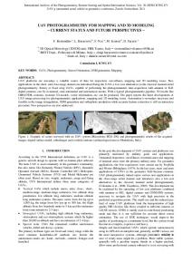
Figure 1: Google SketchUp Tools Sources: http://sketchup.google.com/ Figure 1: Tools of Software
Figure 2: Shivaji University Campus Model prepared with Google SketchUp
381
ISSN: 2277-7962 7. CONCLUSION The objects on earth surface are having several dimensions. Many times there are limitations to represent the 3D reality on 2D. The visualization and understanding is better on 3D. The use of 3D software is continuously increasing in various fields. There are many 3D mapping and modeling software available in market. Google SketchUp is one of the simple, easy to handle and important open source software application. It can be used at educational level efficiently to demonstrate the complicated things by systematic manner. The interface of the software is very simple and the tools are easy to use. The user can draw the object very fast and decorate it beautifully. The colour schemes and designing tools is user friendly. Its help is very simple to understand new user and its demonstration videos are available for further guidance. In short the Google Sketchup is very simple and systematic application which must be learned by every academician in their daily teaching and learning activities. 8. REFERENCES: [1] From Wikipedia: https://en.wikipedia.org/wiki/Digital_India [2]marketsandmarkets.com, Publishing Date: October 2015, 3D Mapping and 3D Modeling Market by Application in 3D Mapping (3D Projection Mapping, Mapping and Navigation, and Others), by Vertical (Healthcare, Building and Construction, and Others), and by Geography - Forecast to 2020. http://www.marketsandmarkets.com/Market‐Reports/3d‐mapping‐market‐819.html [3] Hardik Panchal, Rizwan Khan and SmitaSengupta, GISE Advance Lab, Indian Institute of Technology, Bombay , Powai, Mumbai. [4] From Wikipedia: http://en.wikipedia.org/wiki/List_of_3D_modeling_software. [5] Julian F. Fleron, (2009), Google SketchUp: A Powerful Tool for Teaching, Learning and Applying Geometry, Professor of Mathematics, Westfield State College, Westfield, MA [6] Google SketchUp: http://sketchup.google.com/ Video “New to Google SketchUp”: http://sketchup.google.com/training/videos/new_to_gsu.html [7] Google 3D Warehouse: http://sketchup.google.com/3dwarehouse/ [8] U. Baaser, R. Laudien, G. Bareth : GIS-based Smart Campus System using 3D Modeling, University of Cologne, Germany.
382