2011 International Conference on Computational Intelligence and Communication Systems
GPS Locator: An Application for Location Tracking and Sharing using GPS for JAVA Enabled Handhelds Ankur Chandra, Shashank Jain, Mohammed Abdul Qadeer Department of Computer Engineering Zakir Hussain College of Engineering and Technology Aligarh Muslim University, Aligarh 202002, India {ankurchandra, shashankjain}@zhcet.ac.in,
[email protected]
Today mobile communication devices are becoming much more technologically advanced and offer more features than just conversation. In cell phones, global positioning system (GPS) tracking and sharing are some of the advancements. GPS Systems can be used while outdoors for activities such as hiking or camping. According to a new report from the research firm Berg Insight; “revenues from mobile location based services (LBS) in the European market will grow by 34 percent annually to reach €622 million in 2010” [1]. This number shows how important LBS applications are becoming to the mobile users. As GPS technology has become more important and accessible to consumers, the varieties of GPS enabled devices has also increased with an incredible rate. At the time that the technology gets more advanced, even smaller and more versatile, handheld portable GPS devices are becoming increasingly popular like mobile phones. The popularity of mobile devices is significantly higher among the youths or teens. In Portugal, according to an INE statistic, 85% of the population aging between 10 to 15 years old usesmobile phones [2]. Assuming a hypothetical situation, someone lost at a place of which he is not much aware of, so the user can find his current location on Google maps using the GPS LOCATOR and can send it to a web server or to a friend via a short message service (SMS) through GSM/CDMA network. This approach can also be useful in medical emergencies and military operations. Moreover, several users of this application can share their locations through a web server. These kinds of services attract more users towards the LBS. This application gives the tracks of user’s location through a web server to the other people if there is a sharing bond between the user and the people. This paper proposes a system that uses a regular mobile phone equipped with a GPS receptor and connected to a global system for mobile (GSM/CDMA) network that takes advantage of these technologies in behalf of the user safety. In the scenario of an emergency situation when the user is threatened, GPS LOCATOR permits the user to send his GPS coordinate through a SMS. The implementation of this system is presented in paper [3] using the approach described here. The rest of the paper is organized as follows. Section II reviews the related work focusing on location-based services, and other similar approaches. Section III describes
Abstract---- The use of mobile devices has become a part of our daily routine. Recently, mobile devices like mobile phones or portable digital displays (PDAs) are equipped with global positioning system (GPS) receptors that allow us to get the device’s geographic position in real time. Location Based Services (LBS) are regarded as a key feature of many future mobile applications. GPS serves well for most outdoor applications; however, its dependence on satellites makes it ineffective for indoor environments. This document gives a detail on our ongoing project work in the field of Location Based Services for JAVA enabled mobile devices, equipped with GPS receptor. We present a novel technique to send GPS coordinates to other mobiles through Short Message Service (SMS) based on Global Positioning System (GPS) technology. This application also enables the users to get their current location coordinates (latitude, longitude and altitude) and they can also view their locations on the Google maps. Further, this application also enables the user to share his location with their friends through a web server using internet connectivity in their handhelds. GPS is a satellite-based navigation system made up of a network of 24 satellites placed into orbit by the United States (US) Department of Defense (DoD). GPS was originally intended for military applications, but in the 1980s, the government made the system available for civilian use. GPS can show you your exact position on the Earth in any weather conditions, anywhere in the world, 24 hours a day. There are no subscription fees or setup charges to use GPS [6]. Keywords—GPS; LBS; J2ME; MidMaps; Google Maps; GSM; CDMA;
I.
INTRODUCTION
Location Based Service (LBS) has been considered as the most potential part of wireless value-added services. However, the development of Location Based Services, which needs lots of data to transmit, is strictly limited because of the limited bandwidth of wireless network. With the emergence of 3G and 4G technologies, wireless network speed is greatly improved, which will provide more information to users easily, and hence LBS will be greatly promoted.
978-0-7695-4587-5/11 $26.00 © 2011 IEEE DOI 10.1109/CICN.2011.85
413 407 406
the application development including its requirements, architecture and the technologies employed. Section IV evaluates our approach, user interface and application functionality along with experimental evaluation and validation. Section V is about some discussion on the whole paper. Finally, section VI presents the conclusions and some possible future enhancements in work. II.
very easy to deploy in a regular mobile phone with GPS receptor. For the user safety, the GPS Locator application can be useful in emergency scenarios, for instance kidnapping, thereby giving the user the option to send his location calls via SMS. III.
RELATED WORK
APPLICATION DEVELOPMENT
In this section, we will discuss the requirements of the GPS LOCATOR application, the application architecture and the technologies required for its deployment. Our emphasis will be on existing architectures, as well as emerging ones that foster its practical deployment.
This section deals with some of the existing works related to the proposed mobile solution, mainly, using tracking systems through GPS or GSM cell. In paper [4], the author proposes an application “Locating Friends and Family Using Mobile Phones with Global Positioning System (GPS)” based on client-server architecture that helps the users to locate their family members and receive alerts when their friends are nearby. The mobile application was implemented using J2ME where the most recent APIs and other older APIs were combined together in order to make the application reliable on all types of mobiles. The server was implemented using PHP since PHP guarantees that the server would not be overloaded. The type of the Database used in the system was MySQL. In paper [5], a technique is given to send GPS coordinates of a mobile through a SMS to other mobile phones. Two algorithms, Kalman Filter and Velocity Renovation, which can be used in conjunction with GPS, are used as a basis for location tracking. The first coordinates are generated from a GPS assisted mobile on Google map, this location is then sent through SMS to another person. The latter can then see the exact location of the sender on his map with an accuracy of 0.57m. In paper [8], two techniques were described to locate and track cellular phones using digital cellular mobile telephony networks. The first technique is based on time of arrival (TOA) methods with a minimum of three base stations required, while the later uses angle of arrival (AOA) methods that require only two base-stations, though greater accuracy is possible with three. Both TOA and AOA methods were examined for a multipath fading environment. There are already several applications in the market that offer tracking systems and anti theft applications. Anti theft applications like mGuard [9]. Tracking applications such as, Mobile Tracking System 1.14 [10], AccuTracking [11], and PhoneBak (also an anti theft application) [12], are already rooted in the mobile phone market. As it may be seen in the above-mentioned systems, most of them provide dedicate solutions using tracking methods to monitor a mobile device. Our proposal is designed for a regular mobile phone that incorporates a GPS. Unlike the systems mentioned above, the main feature of our application provides the user the ability to locate him, send your own location via SMS and share his location with friends through a web server. We have gathered suggestions of approaches in order to build the system described in the given sections. The proposed solution can furnish better functionalities and is
A. System Requirements A mobile application has specific requirements that GPS Locator also copes with. According to ubiquitous computing principles, the user interface must be as easy to use as possible, with minimal input from the user. Screen size and orientation together with stylus input minimization dictate an interface with large buttons and appropriate fontsize that enable on-the-move application use. Figure 1 shows the GPS Locator requirements. The major requirement of a GPS Locator is the use of Location Based Services (LBs) such as GPS. The GPS Locator allows several operations such as user can get your own current location (latitude, longitude and altitude) and can view these co-ordinates on the Google maps using MidMaps api [6] for J2ME platform. Further User can send this information via SMS through a GSM/CDMA network to any valid mobile phone number anywhere in the world. GPS Locator also provides the location sharing capability between two or more people through a web server. If a user wants to share his location with one of his friend he just need to enter the mobile phone number of his friend by selecting the share me option from list and press ok button. In order to view friends, user needs to select the get friends’ location option from list menu of GPS Locator. Suppose a user A and User B are sharing their location. So, A and B can view each other’s location with the time at which the user updated his location and can see this location on map. The GPS Locator continuously updates the web server’s database with the user’s current location by using the ENABLE SHARING command. After this, the GPS Locator calculates the user’s current location and sending it to the server and updates the location attributes of corresponding user in the database table. In order to reduce the battery overhead due to the GPS receiver, the developers of this application allow the application to update the database after a particular time interval instead of calculating GPS data continuously. User can also cancel the sharing bond with any of his friend with whom user was sharing his location. If the user doesn’t want to update his location or to reduce the battery consumption he can disable the location sharing mode. If the user is in some emergency condition he can send his location to the emergency numbers which are already in the GPS Locator’s database. So the emergencies
407 408 414
can aware the user’s most appropriate location to provide him the emergency services such as medical, police etc.
Figure 1: GPS Locator requirements .
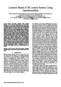
B. Application Architecture Data from the application settings and emergency contacts are saved in a database file. When the application is started; the data is loaded from the data file and will apply it to behave according to those parameters. To better understand the user interaction with GPS Locator, the corresponding UML class diagram is shown in Figure 2. This diagram is made using Fujaba Tool Suite RE 4.2.0[14]. The current location of the user is calculated using inbuilt GPS receiver in the phone. The calculated coordinates of the user is showed on the map using a third party Google maps API called MIDMAPS. Further these coordinates can be sent to any valid mobile number through a SMS. The text message cannot be edited by the user because of security reasons. The application architecture and its working principle are centered on the use of GPS. It is the most common technology for these kinds of applications. Other possible approaches may include a combination of other LBs like GSM cell ID, wireless hot spots or via Bluetooth. Crossing data from all the LBs should provide much more accurate position of the device. Further, unlike the GPS, the GSM cell ID, wireless hot spots and tracking via Bluetooth are able to get the device’s position even at indoors
Figure 2: GPS Locator UML diagram
The centralized database server provides a coordinate’s database to the users so they can get the location of friends and relatives and updates their own location on the server. The purpose of choosing centralized data sharing is to reduce the storage overhead on each phone. Otherwise, instead of using centralized database each mobile may have its own database stored on the phone and share these databases between different users. C. Technologies The mobile application targets JAVA platform. We have decided to develop the application using JAVA 2.0 Micro Edition. It includes large programming libraries, solutions for common problems. We develop this application under CLDC 1.1[12] device configuration and MIDP 2.0[12] device profile. The software chosen for the development of this application is Java(TM) ME Platform SDK 3.0. The SDK is free of cost so anyone can develop your own applications and market it. For database hosting on server site we are using Mysql database and PHP language. We use PHP because it runs on server side and so again reducing the overhead from the
408 409 415
mobile device. For local hosting we used WAMPSERVER software which includes MYSQL, PHP and apache HTTP server in one package. It also includes PHPMYADMIN. With the help of these we run our project locally. To show the coordinate on map, we are using a third party Google maps API. It has several functions for handling online Google maps.
the mobile number of the person with whom he wants to share his location or to cancel the existing sharing bond. Emergency provides the facility to send message of current location on pre entered emergency numbers. B. Application validation The purpose of validation is to show that the implemented system satisfies the initial requirements. GPS Locator (and MIDMAPS) validation was performed, using exhaustive running tests that were also performed in design time to collect debug information and change as necessary. We used a real device with all tests, NOKIA 5235 equipped with SIM card and GPS receptor.
IV. EVALUATION AND VALIDATION OF GPS LOCATOR A. User experience and GPS Locator interface This subsection introduces a general idea of mobile application (GPS Locator) as well as, its use in practical deployment. To ease the user interaction with the GPS Locator, the interface is made as simple as possible. The main window of the application is very intuitive. The interface displays a list of functions that a GPS Locator can perform such as where am I, Get Friends location and Emergency etc. the left soft key allows the user to terminate the application and right soft key set the enable sharing mode as shown in figure 3.
Figure 4: Location Coordinates.
Figure 3: An interface of GPS Locator
If user wants to have his own location, he can get, using “Where Am I” option and can view that location on map by selecting the command ShowOnMap (figure 4). User can also send this location via SMS by choosing Send My Location option. This option displays user’s current location and asks for number on which user want to send this location (figure 5). User can search your own phonebook to select a destination number. Get Friends’ Location option display a list of friends with whom, user is currently sharing his location. By selecting one of them from the list, user can view his location in text form as well as on Google maps. Share Me allow users to establish a bond of sharing with anyone or cancel the existing bond. User just needs to enter
Figure 5: Coordinates on Google Maps.
409 410 416
the user is located. Other future extensions can be summarized as follows: •
Improvement in user Interfaces.
•
Support for external Bluetooth GPS receiver.
•
Speed Calculation.
•
Compass
•
Accuracy can be improved by several algorithms.
•
Centralized database for nearby emergencies.
REFERENCES [1] Axel Küpper , Location-based services, fundamentals and operation, WILEY, 2nd edition, 2005. [2] Instituto Nacional de EstatÌstica. http://www.ine.pt/. Accessed on October 2010. Figure 6: Send My Location [3]
V.
DISCUSSION
Based on the tests that measure the system performance, the system has some strong and weak features: •
The system built is portable and can run on any mobile phone that supports J2ME.
•
The system can run on mobiles that have a built in GPS Receiver.
•
•
[4] Ghaith Bader Al-Suwaidi; Mohamed Jamal Zemerly; “Locating Friends and Family Using Mobile Phones With Global Positioning System (GPS)” in Computer Systems and Applications, 2009, AICCSA 2009. IEEE/ACS International Conference on 10-13 May 2009 [5] Mohammad Zahaby; PraveshGaonjur; SaharFarajian; “LOCATION TRACKING IN GPS USING KALMAN FILTER THROUGH SMS” in EUROCON 2009, EUROCON '09. IEEE on 18-23 May 2009.
On the mobile side, the application size is small because all user lists and other data are stored on the server.
[6]
GPS does not work at indoors. This problem was solved by always storing the last location updated by the application.
“MidMapsGoogle MapsApi for J2ME”. http://www.jappit.com/blog/midmaps-google-maps-java-me-library/. Accessed on October 2010.
[7] http://www8.garmin.com, "What is GPS?".Accessed on October 2010. [8] Jami, I.; Ali, M.; Ormondroyd, R.F.; "Comparison of methods of locating and tracking cellular mobiles" in Novel Methods of Location and Tracking of Cellular Mobiles and Their System Applications (Ref. No. 1999/046), IEE Colloquium on 17 May.
The system provides the user with the member time of update whenever a friend location is requested. This will help the user to know whether the location is recently updated or not. VI.
Ankur Chandra; Shashank Jain; Mohammed Abdul Qadeer; “Implementation of Location Awareness and Sharing System Based on GPS and GPRS Using J2ME, PHP and MYSQL” in proceedings of 3rd International Conference on Computer Research and Development (ICCRD-2011)IEEE on 11-13 March 2011..
[9] Mobile Tracking System 1.14. http://wareseeker.com/NetworkInternet/mobile-tracking-system-1.14.zip/20284d547. Accessed on October 2010.
CONCLUSION AND FUTURE WORK
A J2ME mobile application based on providing Location Based Service using Global Positioning System (GPS) as a location provider is presented. The application aware the user with his current location coordinates and shows it on Google Maps. The application is also implemented as a client server system that helps users to locate their friends or anyone with whom he wants to share his location. The location average accuracy using this system is believed to be within couple of meters. The application works in open space areas only since it relies on GPS. Future extensions may look at other options such as getting the location from the service provider. In this case the location accuracy will be reduced and will depend on the size of the cells where
[10] AccuTracking. http://www.accutracking.com/. Accessed on October 2010. [11] Back2u Mobile Security. http://www.bak2u.com/phonebak.php. Accessed on October 2010.
410 411 417
[12]
Connected Limited Device Configuration (CLDC) http://java.sun.com/products/cldc. Accessed on October 2010.
.
[13]
Mobile Information Device Profile (MIDP). http://java.sun.com/products/midp/whatsnew.html. Accessed on October 2010.
[14]
Fujaba Tool Suite 4.2.0. http://www2.cs.uni-paderborn.de/cs/agschaefer/Lehre/PG/FUJABA/projects/reengineering/index.html. Accessed on October 2010.