Abstrct The detection of ground plane and free space remains challenging for non-flat plane, especially with the varying latitudinal and longitudinal slope or in ...
Non-flat Road Detection with a Local Descriptor Kangru Wang, Lei Qu, Lili Chen, Yuzhang Gu, Dongchen Zhu, Xiaolin Zhang Shanghai Institute of Microsystem and Information Technology (SIMIT), Chinese Academy of Sciences (CAS)
Abstrct The detection of ground plane and road remains challenging for non-flat plane, especially with the varying latitudinal and longitudinal slope or in the case of multi-ground plane. In this paper, we propose a framework of the ground plane detection with stereo vision. Index Terms Ground Plane Detection, Road Estimation, Local Descriptor, Stereo Vision, Convolutional Network. I.INTRODUCTION Ground plane and road detection is a key component of intelligent vehicle applications and mobile robot system. The information of drivable space and understanding of the environment can improve traffic safety and efficiency. With the development of Driver Assistance Systems (ADAS) and Collision Avoidance Systems (CAS), frees pace detection has become an important research area of computer vision. Ground plane detection can be used for pitch angle compensation[[1] and improving the accuracy of obstacle detection [2], and free space estimation. Free space estimation is applied widely in many applications such as vehicle navigation [3] and pedestrian or vehicle detection [4, 5]. Labayrade et at[6] proposed the well-known ‘V-disparity algorithm’ which is a common approach for the ground plane modeling. The algorithm simplifies the extraction of the 3D ground and obstacle into a 2D linear process without using any prior knowledge of the scene appearance. The ’V-disparity’ widely used to detect the ground plane [7-12]. [8]use a u-disparity map to get the detail information of ground. Traditional methods based on V-disparity map have some limitations in detecting non-flat ground especially in the off-road environment. Some more robust algorithms have been proposed to extract the non-flat ground plane .In[6] the authors assume that the ground plane can be modeled as piecewise linear and non-flat ground plane can be modeled by a few linear lines. [8, 13-15] address the problems with the ground plane of different longitudinal slope. But these methods usually fail in complex scene especially with wide variance of latitudinal slope and multi-ground plane. [18] use sliding window paradigm to address the detection of the ground plane with variable latitudinal slope and multi-ground plane. The plane is considered locally plane in very corresponding window, and sub-V-disparity map is created to represent the details of ground plane. But the number of window is hard to decide. There are also some algorithms preserve the physical properties of the ground plane in Euclidian space[17-21]. [16]estimates ground plane using multivariate polynomial in the YZ plane domain .In[19,20],the input 3D map is reduced to a 2D map by accumulating all the points into a histogram of height versus distance which is similar to the v-disparity map creation. [21-23] applied a 2D quadratic surface fitting. [22, 23]introduces a method to estimate the planar patches for the Euclidian domain from the disparity map and then exploited the estimated patch parameters for eliminating outliers during road fitting. The traditional estimation of free space is usually based on the construction of occupancy grids [24, 25].The occupancy grid method models the occupancy evidence of the environment using a two-dimensional array or grid. Each cell of the occupancy grid maintains the probability of occupancy. However, these methods require the knowledge of the stereo sensor characteristics to compute depth map or 3D Euclidian point cloud as an initial step. With the development of deep learning, some algorithms to detect free space or road have been proposed. [26] proposed a network to detect road that takes advantage of a large contextual window and uses a Network-in-Network (NiN) [27] proposed a multi-layer CNN architecture with a new loss function to detect free space.
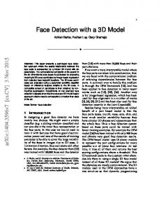
In this paper, we propose a framework of the ground plane and road estimation with stereo vision. The main contributions of this paper are presented as follows. First, we obtain a texture map where the ground plane regions can be distinguished from their surroundings effectively. Second, the texture map is segmented into superpixel regions and use a convolutional neural network architecture to classify every superpixel region. We use the contextual information around the consider superpixel region to improve the accuracy of the model. II PROPOSED APPROACH Our proposed method mainly consists of three steps, i.e. compute a disparity texture image, segment the disparity texture image, and detect the ground plane region using convolutional neural network architecture. A. Ground detection (1). Compute the disparity texture image Six typical planes in the world coordinate system are illustrated in Fig. 2(a) and their disparity maps are shown in Fig.2(b). The plane ① represents the horizontal ground plane, while the plane ② and the plane ③ represent the ground plane with latitudinal and longitudinal slope. The disparity value on the above typical ground plane should decrease gradually from the bottom to the top along vertical coordinate, while the disparity value keeps constant on the plane ①, ③ and decreases gradually on the plane ② along the horizontal coordinate. The plane ④, ⑤ and ⑥ represent the typical planes of obstacle, which have different disparity characteristics from the ground plane. In this paper, the disparity texture image can be obtained from disparity image with the sobel operator. This feature of the disparity texture image can distinguish ground plane regions from their surroundings effectively. In this paper, the dense disparity estimation is performed using the algorithm of [28] with the reason of high quality.
Fig. 2 Examples of the Disparity Texture Map. (a) Typical planes in world coordinate system. (b) The six images in the first row are the disparity maps of the planes in figure (a). The six images in the second row are the binary maps of the Disparity Texture Maps for visualization. The labels are consistent with the planes in figure (a). The color in the disparity maps encodes the disparity value.
(2). Segment the disparity texture image The second step in our proposed framework is to segment the disparity texture map with the SLIC superpixel algorithm. Simple linear iterative clustering (SLIC) [29] is a good algorithm to generate superpixels by using spatial and color information with computational and memory efficiency. Ideally, the small region segmented by superpixel belongs to the same object. In addition, it shows excellent boundary adherence which can help improve the precision of segment between ground and non-ground region.
Thus, we utilize the SLIC superpixel algorithm to segment the stereo left image into superpixel regions. Then, rule of segment is used to divide the disparity texture image into corresponding superpixel regions. The feature extracted for each superpixel is used to determine the region class (ground or non-ground). We consider all the pixels in the superpixel region have the same class. (3). detect ground plane region In this step, we propose a convolutional neural network architecture to classify every superpixel region into ground or non-ground. It consists of extracting patches around superpixel regions of the disparity texture image and predicting the label of the superpixel using a trained CNN. To reduce the impact of disparity estimation error and improve the accuracy of prediction, a possible solution is to make use of the contextual information around the considered superpixel region. Thus, in this framework we input the image patches centered at the centroid of each superpixel to our network and the output is a class (ground or nonground) of the considered superpixel region. Because the feature in disparity texture image is very obvious, we use a simple net architecture inspired by the LeNet-5 architecture which is also proposed to implement on gray image initially. B Road Segmentation The prior work usually detected road based on color information, which have a limited in the situations of extreme Illumination and road texture. To deal with above situations, we exploit the disparity texture map in the road detection. In this paper, we exploit multiple modalities of data in road detection. We propose a Multi-Information network which takes a multi representation of disparity texture map and an RGB image as input. The approach makes the extraction of a feature set based on color and disparity information. To combine information from different features, we use late fusion in the network. The network architecture of our Multi-Information network is illustrated in Fig. 4, which is inspired by [26]. The input to the network is the patches of three-channel RGB image and disparity texture map and its output is a class (road or non-road) that is attributed to the 4×4 region in the center of the patches. To classify a whole image, a patch should be extracted and classified for every 4×4 region of the original image with a 4×4 stride). Each path of the network itself starts with a conv. 3×3 - 32 (32 filters sized 3×3 each) layer, followed by a conv. 1×1 - 16 and a max-polling layer of 2×2. These three layers are repeated in sequence with the same parameters. Finally, there is a fully-connected layer with 1000 neurons and a final layer with 2 neurons (one for each class). All convolutional layers have a stride of 1×1, are followed by the ReLU activation function and do not employ padding. The first fully connected layer is followed by the ReLU function while the final layer implements the Softmax loss function.
Fig. 4: The architecture of Multi-Information network.
III.EXPERIMENT RESULT A. Dataset For the estimation experiments on ground detection we use the raw data available in the KITTI dataset [31]. The dataset consists of 122 images as training images and 303 as testing images, and ground truth is generated by manually. We choose the training images from 7 diverse sequences (09_26_d_09, 09_26_d_18, 09_26_d_35, 09_26_d_48, 09_28_d_34, 09_28_d_45, 09_28_d_68). and the testing images are chosen from other 10 diverse sequences (09_26_d_17, 09_26_d_39, 09_26_d_61, 09_26_d_64, 09_26_d_86, 09_26_d_93, 09_28_d_66, 09_30_d_33, 10_03_d_27, 10_03_d_47).This diverse sequences are obtained from different categories including city, residential, road, person and campus where terrains rang from plane to non-plane ground. The experiment on road detection is evaluated on the datasets from the KITTI road benchmark [31]. The data are categorized in three sets having each one a subset of training and test images, representing a typical road scene in inner-city. The images in UU set are taken from urban unmarked area which have 98 training images and 100 testing images. The images in UM set are taken from urban marked two-way road which have 95 training images and 96 testing images. The images in UMM set are taken from urban marked multi-lane road, which have 96 training images and 94 testing images. B. Ground detection (1)Training Scheme We created training and validation samples from the training images. Each sample consists of the image patch and its referent class. To create the samples, we extracted the image patch centered at the centroid of each superpixel region and the class (ground or non-ground) is attributed to the considered superpixel region. To make the balance of the samples, we sampled the non-ground class samples. We conduct the training using stochastic gradient descent. (2). Evaluation Result We compare our approach with two baselines: V-disparity [6] and Sub-V-disparity [18]. Fig.3 shows a sample of the obtained results. These demonstrate that our algorithm is able to provide superior average performance on nonflat ground.
Figure 4: From the first to third column are the example results of v-disparity, sub-v-disparity and our method. C. Road Segmentation (1) Training Scheme Using the training images, we created training and validation datasets for each of the patch sizes tested. Each sample consists of the two patches of RGB image and disparity texture map. To create the samples, we scan the image skipping 4 pixels in each axis (stride of 4) and extracted the patch centered around each 4×4 region. We included only samples whose 4×4 regions are of a single class, ignoring ambiguous samples. All images are padded (using reflection) so the 4×4 regions cover the full original image.
(2) Inference At inference time, our Multi-Information network is converted into a Fully Convolutional Network (FCNs) by converting the fully connected layers into convolutional layers. Concretely, we convert the two fully connected layer in our model to convolutional layers. (3) Evaluation Result We evaluate our approach with the approach proposed by [26], Fig. shows the qualitative results. In the situation of extreme Illumination and rare road texture, our approach provides more precise segmentation of the road than the baselines.
Figure 4: The images in first row are the result of approach [26]. The images in second row are the result of our approach.
IV. CONCLUSION We present a method of ground plane and road estimation with stereo vision. A complete framework is proposed to detect the ground plane region base on the disparity texture image with a convolutional neural network architecture. The framework is shown to provide robust results over a variety of terrains from KITTI’s benchmark. Our framework also benefits traditional methods with better results. REFERENCES [1]
R. Labayrade, D. Aubert, and J.-P. Tarel, “Real Time Obstacle Detection in Stereovision on Non Flat Road Geometry Through v-disparity Representation,” Intelligent Vehicle Symposium, pp. 646-651, 2002.
[2]
A. Wedel, H.Badino, C. Rabe et al., “B-Spline Modeling of Road Surfaces With an Application to Free-Space Estimation,” IEEE Transactions on Intelligent Transportation Systems, vol. 10, no. 4, pp. 572-583, 2009.
[3]
M. Muffert, T. Milbich, D. Pfeiffer et al., “May I Enter the Roundabout? A Time-To-Contact Computation Based on Stereo-Vision,” Intelligent Vehicles Symposium, pp. 565-570, 2012.
[4]
J. K. Suhr, K. M. Kang, and H. G. Jung, “Dense stereo-based critical area detection for active pedestrian protection system,” Electronics Letters, vol. 48, no. 19, pp. 1199-1201, 2012.
[5]
M. Enzweiler, M. Hummel, D. Pfeiffer et al., “Efficient Stixel-Based Object Recognition,” Intelligent Vehicles Symposium, 2012.
[6]
R. Labayrade, D. Aubert, and J. P. Tarel, “Real Time Obstacle Detection in Stereovision on Non Flat Road Geometry Through "V-disparity"Representation,” Intelligent Vehicle Symposium, 2002.
[7]
R. Labayrade, and D. Aubert, “A Single Framework for Vehicle Roll, Pitch, Yaw Estimation and Obstacles Detection by Stereovision,” Intelligent Vehicles Symposium, 2003.
[8]
C. D.Jones, A.B.Smith, and E.F.Roberts, “A Complete U-V-Disparity Study for Stereovision Based 3D Driving Environment Analysis,” 3-D Digital Imaging and Modeling, IEEE Fifth International Conference, pp. 204-211, 2005.
[9]
N. Soquet, D. Aubert, and N. Hautiere, “Road Segmentation Supervised by an Extended V-disparity Algorithm for Autonomous Navigation,” Intelligent Vehicles Symposium, 2007.
[10]
C. Teoh, C. Tan, and Y. C. Tan, “Ground Plane Detection for Autonomous Vehicle in Rainforest Terrain,” Sustainable Utilization and Development in Engineering and Technology, 2010.
[11]
J. Qin, and A. Ping, “Depth Extraction Method Based on Multi-view Stereo Matching,” Computer Engineering, vol. 36, no. 14, pp. 174-176, 2010.
[12]
K. Atsuta, and K. Hamamot, “A Robust Road Profile Estimation Method for Low Texture Stereo Images,” ICIP, pp.
4273-4276, 2009. [13]
R. Labayrade, and D. Aubert, “A Single Framework for Vehicle Roll, Pitch, Yaw Estimation and Obstacles Detection by Stereovision,” Intelligent Vehicles Symposium, pp. 31-36, 2003.
[14]
N. Soquet, D. Aubert, and N. Hautiere, “Road Segmentation Supervised by an Extended V-disparity Algorithm for Autonomous Navigation,” Intelligent Vehicles Symposium, pp. 160-165, 2007.
[15]
C. W. Teoh, C. S. Tan, and Y. C. Tan, “Ground Plane Detection for Autonomous Vehicle in Rainforest Terrain,” Conference on Sustainable Utilization and Development in Engineering and Technology, pp. 7-12, 2010.
[16]
S. Nedevschi, R. Danescu, D. Frentiu et al., “High accuracy stereovision approach for obstacle detection on non-planar roads,” In Proceedings of the Intelligent Engineering Systmes, pp. 211–216, 2004.
[17]
A. D. Sappa, F. Dornaika, D. Ponsa et al., “An Efficient Approach to Onboard Stereo Vision System Pose Estimation,” Transactions on Intelligent Transportation Systems
[18]
vol. 9, no. 3, pp. 476 - 490, 2008.
D. Yiruo, W. Wenjia, and K. Yukihiro, “Complex Ground Plane Detection Based on V-disparity Map in Off-road Environment,” Intelligent Vehicles Symposium pp. 1137-1142, 2013.
[19]
S. Nedevschi, R. Schmidt, T. Graf et al., “3D lane detection system based on stereovision,” Intelligent Transportation Systems, 2004.
[20]
A. Wedel, H. n. Badino, C. Rabe et al., “B-Spline Modeling of Road Surfaces With an Application to Free-Space Estimation ” Transactions on Intelligent Transportation Systems, vol. 10, no. 4, pp. 572-583, 2009.
[21]
F. Oniga, and S. Nedevschi, “Processing Dense Stereo Data Using Elevation Maps: Road Surface, Traffic Isle, and Obstacle Detection ” Transactions on Vehicular Technology
[22]
vol. 59, no. 3, pp. 1172 - 1182, 2010.
X. Ai, Y. Gao, J. G. Rarity et al., “Obstacle detection using U-disparity on quadratic road surfaces,” Intelligent Transportation Systems, pp. 1352-1357, 2013.
[23]
U. Ozgunalp, X. Ai, and N. Dahnoun, “Stereo vision-based road estimation assisted by efficient planar patch calculation,” Signal, Image and Video Processing, vol. 10, no. 6, pp. 1127-1134, 2016.
[24]
H. Badino, U. Franke, and D. Pfeiffer, “The stixel world-a compact medium level representation of the 3d-world,” Joint Pattern Recognition Symposium, pp. 51-60, 2009.
[25]
H. Badino, U. Franke, and R. Mester, “Free Space Computation Using Stochastic Occupancy Grids and Dynamic
[26]
C. C. T. Mendes, V. Frémont, and D. F. Wolf, “Exploiting Fully Convolutional Neural Networks for Fast Road Detection,”
Programming,” Workshop on Dynamical Vision, vol. 20, 2007.
International Conference on Robotics and Automation, 2016. [27]
D. Levi, N. Garnett, and E. Fetaya, “StixelNet: A Deep Convolutional Network for Obstacle Detection and Road Segmentation,” BMVC, 2015.
[28]
Z. J, and L. Y, “Stereo matching by training a convolutional neural network to compare image patches,” Journal of Machine Learning Research, vol. 17, pp. 1-32, 2016.
[29]
R. Achanta, A. Shaji, K. Smith et al., “SLIC Superpixels Compared to State-of-the-Art Superpixel Methods,” Transactions on Pattern Analysis and Machine Intelligence, vol. 34, pp. 2274-2282, 2012.
[30] [31]
M. Lin, Q. Chen, and S. Yan, “Network in network,” arXiv preprint arXiv, vol. 1312, no. 4400, 2013. A. Geiger, P. Lenz, and R. Urtasun, “Are we ready for autonomous driving? the kitti vision benchmark suite,” Computer Vision and Pattern Recognition (CVPR), vol. 2012 IEEE Conference on, no. IEEE, 2012.