Austrian Journal of Earth Sciences
Volume 106/2
Vienna
2013
Hydrocarbon generation and migration from sub-thrust source rocks to foreland reservoirs: The Austrian Molasse Basin___________________________________________________ Jürgen GUSTERHUBER1)2)*) , Ralph HINSCH3)4), Hans-Gert LINZER3) & Reinhard F. SACHSENHOFER1) 1)
Montanuniversität Leoben, Department Applied Geosciences and Geophysics, Chair of Petroleum Geology,
1)
Peter-Tunner-Straβe 5, A-8700 Leoben, Austria;
2)
Present address: SANTOS Ltd., 60 Flinders Street, Adelaide SA 5000, Australia;
3)
RAG Rohöl-Aufsuchungs Aktiengesellschaft, Schwarzenbergplatz 16, A-1015 Vienna, Austria;
4)
Present address: OMV Exploration & Production GmbH, Trabrennstraβe 6-8, 1020 Vienna;
*)
Corresponding author,
[email protected]
KEYWORDS hydrocarbon migration petroleum system Molasse Basin modelling
Abstract The present study shows structural and petroleum systems models investigating the hydrocarbon potential of the central part of the Austrian Molasse Basin. The structural model is based on kinematic modeling with pseudo-geodynamic background. It reflects the structural evolution of the frontal and adjacent orogenic wedge and serves as input for the basin and petroleum systems models. Total tectonic shortening in the forward modeled section is 48.5 km, corresponding to 69% of shortening.__________________________________________ The reconstructed paleo heat flow based on maturity data is low (32 - 26 mW/m2) and decreases southwards towards the orogen. Formation temperatures suggest that present-day heat flows decrease in the same direction from 52 to 37 mW/m2. Most probably heat flow is increased during Pliocene and Pleistocene times.________________________________________________________ A combination of ‘paleo’ and ‘present day’ heat flow scenarios was used for the calculation of hydrocarbon generation along a N-S trending section crossing the Sierning imbricates. According to these models, hydrocarbon generation commenced during the Early Miocene at about 18 Ma due to deep burial beneath Alpine nappes and was terminated during the Late Miocene (~ 8 Ma) due to cooling caused by uplift and erosion. About 40 % of the total source potential was realized beneath the Northern Calcareous Alps in the Molln 1 Well area. Hydrocarbon migration commenced contemporaneously with hydrocarbon generation, but continues until present day. Despite of model simplifications, the 2D migration model reflects important processes confirming previous interpretations. Amongst these are: (1) oil migration across faults from the Oligocene source rocks into stratigraphically deeper carrier/reservoir beds; (2) long-distance (>50 km) lateral migration of oil (and gas); (3) migration of gas along fault zones into the Sierning imbricates; (4) vertical migration of gas into the Puchkirchen and Hall formations, probably as a result of uplift and pressure reduction.________________________ Results of a ‘pseudo 3D‘ flow path model show that absence of commercial accumulation in the western part of the study area is not a result of missing structures, but of the absence of hydrocarbon charge. The mismatch between observations and model results also highlights the important role of fault zones as migration pathways._________________________________________________ ‘Palaeopasteurization’ of shallow reservoirs may explain that biodegradation in the Austrian part of the Alpine Foreland Basin is limited to the depth interval down to 800-1000 m sub-sea.___________________________________________________________ Die vorliegende Arbeit zeigt Struktur- und Kohlenwasserstoffsystem-Modelle, welche das Potential des zentralen Teils des österreichischen Molassebeckens erforschen._________________________________________________________________________ Das strukturgeologische Modell schließt die Entwicklung des erweiterten nördlichen Randes des alpinen Orogens mit ein und dient gleichzeitig als Grundlage fuer das Beckenmodell. Die tektonische Verkürzung im Modell wurde mit 48.5 km angenommen, was 69 % Gesamtverkürzung entspricht._________________________________________________________________________ Der rekonstruierte Paläowärmefluss, basierend auf Reifedaten, ist relativ niedrig und nimmt von Norden nach Süden ab (32 – 26 mW/m2). Der errechnete heutige Wärmefluss welcher auf gemessenen Formationstemperaturen basiert, nimmt ebenfalls von Norden nach Süden ab, wenn auch auf höherem Niveau (52 – 37 mW/m2). Wahrscheinlich nahm der Wärmefluss während des Pliozäns oder Pleistozäns zu. Eine Kombination aus diesen beiden Wärmeflussszenarien diente als Grundlage für die Modellierung der Kohlenwasserstoffgeneration entlang eines 2D Profiles in der Sierninger Schuppenzone. Die Modelle zeigen, daß die ersten Kohlenwasserstoffe vor rund 18 Millionen Jahren gebildet wurden und dieser Prozeß vor rund 8 Millionen Jahren zu Ende war. Diese Zeitabfolge kann direkt mit der tiefen Versenkung des Deckenstapels unter die Alpen, gefolgt von nachfolgender Hebung und Erosion vor rund 8 Millionen Jahren, in Verbindung gebracht werden. Ungefähr 40 % des gesamten Muttergesteinspotentials wurden im südlichen Bereich des Profiles unterhalb der Nördlichen Kalkalpen im Bereich der Bohrung Molln1 realisiert._____________________________________ Die Migration der Kohlenwasserstoffe setzt gleichzeitig mit der Bildung derselben ein und bleibt bis heute aktiv. Trotz notwendiger Vereinfachungungen im Modell können mit dem 2D Migratinonsmodell viele Prozeße, welche in früheren Studien bereits als möglich erachtet wurden, visualisiert werden. Diese sind unter anderem: (1) Ölmigration entlang von Störungen von oligozänen Mutterge-
Hydrocarbon generation and migration from sub-thrust source rocks to foreland reservoirs: The Austrian Molasse Basin
steinen in stratigraphisch tiefere Träger- und Reservoirhorizonte; (2) ausgedehnte (>50 km) laterale Migration von Öl und Gas; (3) Gasmigration entlang von Störungszonen in den Bereich der Sierninger Schuppenzone; (4) vertikale Migration von Gas in die Puchkirchen und Hall Formation, welche möglicherweise ein Ergebnis von Hebung und Druckreduktion ist.________________________ Ein auf Strukturkarten basierendes „Pseudo 3D“ Flieβmodell zeigt, daβ das tatsächliche Nichtvorhandensein von kommerziell nutzbaren Petroleumakkumulationen im westlichen Teil des Untersuchungsgebietes auf fehlende Muttergesteine, und nicht auf fehlende Störungsstrukturen zurückzuführen ist.__________________________________________________________________________ Die Diskrepanz zwischen Beobachtungen und Modellierergebnissen zeigt zugleich den groβen Einfluss von Störungszonen, welche als Migrationspfade dienen.____________________________________________________________________________________ ‚Paläopasteurisierung‘ von seichten Gaslagerstätten ist eine mögliche Erklärung dafür, daβ Biodegradation im österreichischen Teil des alpinen Vorlandbeckens auf ein Tiefe von ungefähr 800 – 1000 m (unter Meereshöhe) begrenzt ist.___________________
1. Introduction The Molasse Basin represents the foreland basin at the nor-
most piece of these imbricated zones (Fig. 1) (Hinsch and Lin-
thern edge of the Alps (Fig. 1). The basin fill consists of Meso-
zer, 2010). Due to different timing of tectonic processes, the
zoic and Cenozoic rocks overlying the crystalline basement of
stratigraphic position of the decollement varies between the
the Bohemian Massif (Malzer et al., 1993). Petroleum explora-
eastern and the western basin region. While Upper Cretaceous
tion has been successful for decades. Hence the basin is con-
marls act as detachment horizon in the western part of the
sidered to be mature in terms of petroleum exploration (Veron,
area (Perwang imbricates), the decollement is located above
2005). Two reasonably well understood petroleum systems
Lower Oligocene source rocks in the Sierning imbricates and
can be distinguished in the investigated area of the basin
in the Regau overthrust segment. Therefore, occurrence of
(Wagner, 1996, 1998): (1) a thermogenic oil system related to
source rocks within the thrust sheets is restricted to the Per-
Lower Oligocene source rocks (Schmidt and Erdogan, 1993;
wang imbricates. Gusterhuber et al. (in press) showed (based
Schulz et al., 2002; Sachsenhofer and Schulz, 2006; Gratzer
on modeling results and geochemical data) that source rocks
et al., 2011), and (2) a biogenic dry gas system located in Oli-
at least in deeper parts of the Perwang imbricates reached
go-/Miocene sediments (Schulz and van Berk, 2009; Schulz
the oil window.______________________________________
et al., 2009; Reischenbacher and Sachsenhofer, 2011). Previ-
The aims of this study are to investigate hydrocarbon gene-
ous basin modeling approaches (Schmidt and Erdogan, 1993,
ration in the Alpine sub-thrust and hydrocarbon migration into
1996) showed that oil and thermogenic gas was formed under-
the undeformed foreland. In addition the study addresses bio-
neath the Alpine nappes and migrated laterally to the north.__
degradation and mixing processes of gas. To achieve these
The distribution of gas deposits in the Molasse Basin is an
goals, a two-dimensional basin and petroleum systems model
outcome of several complex processes. Hence, there are still
was established crossing the Sierning imbricates in the eas-
a lot of pending issues concerning generation, migration and
tern part of the study area. Structure maps of the main reser-
alteration of hydrocarbon gases. For instance gas from Oligo/
voir horizons have been used to show possible hydrocarbon
Miocene reservoirs, interpreted as biogenic in origin, may show
migration pathways in map view._______________________
geochemical signatures of thermal gas and locally even con-
The geometry of the thermal basin model is based on a struc-
tains liquid hydrocarbons. This indicates migration of thermo-
tural forward model. Application of forward modeling was es-
genic hydrocarbons from deeper to shallower horizons and
sential to consider the complex evolution of the thrust sheets.
mixing of both petroleum systems (Reischenbacher and Sach-
Also, the Molasse Basin was subjected to recent erosion and
senhofer, 2011).
uplift events which represent an additional challenge in terms
The stratigraphic evolution of the tectonically mainly unde-
of basin modeling. This effect was considered in the thermal
formed foreland is relatively well constrained by hundreds of
basin model using data from Gusterhuber et al. (2012)._____
wells drilled and 3D seismic data (e.g. Linzer, 2001; De Ruig and Hubbard, 2006; Hinsch, 2008; Hubbard et al., 2005, 2009). In contrast, the folded and imbricated southernmost part is
2. Geological Evolution The Northern Alpine (Molasse) Foreland Basin of Austria
still poorly understood and the hydrocarbon potential is not fully explored. First attempts to a better understanding of the folded and imbricated southernmost part of the basin were made by Linzer (2001, 2002, 2009) and Covault et al. (2009). New wells and continued seismic acquisition improved the knowledge in the kinematic evolution and the understanding of the hydrocarbon generation potential of the latter in recent times (Gusterhuber et al., in press; Hinsch, 2013). Within the Austrian part of the basin, different regions of imbricated zones can be distinguished based on different structural architecture and kinematics. The Sierning imbricates represent the eastern-
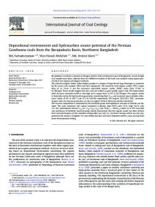
Figure 1: a) Simplified geological map of the study area (outline of the imbricated Molasse from the subsurface); course of the 2D section (A – B) in the Sierning imbricates as well as the area for which the structural model is considered valid and where the thermal model may have significance to have a similar thermal history (yellow shading); wells (approx. status 2010); the inset map (top left) shows the position of the study area on a shaded relief in the frame of Central Europe. b) 2D seismic section; interpretation overlay including calibration wells and main geotectonic units c) generalized structural forward model considered to be valid for the specified corridor and important stratigraphic units (e.g. Eocene reservoir rocks: orange; source rocks: dark grey).______
Jürgen GUSTERHUBER, Ralph HINSCH, Hans-Gert LINZER & Reinhard F. SACHSENHOFER
Hydrocarbon generation and migration from sub-thrust source rocks to foreland reservoirs: The Austrian Molasse Basin
and Bavaria was formed due to collision of the Alps with the southern margin of the European platform during the middle Paleogene (Röder and Bachmann, 1996; Sissingh, 1997) and represents a typical asymmetric foreland basin in terms of an increasing basin depth toward the Alpine thrust front in the south. The basement of the Molasse trough is formed by crystalline rocks of the Bohemian Massif as part of the European continental margin. Mesozoic evolution started with the deposition of Jurassic sandstones and platform carbonates as well as Upper Cretaceous sandstones and marls (Fig. 2). Following on a major uplift and erosion event during the latest Cretaceous and earliest Paleogene, the Paratethys Sea transgressed progressively on a peneplain during the latest Eocene. The onset of Molasse sedimentation is characterized by Upper Eocene fluvial to shallow marine sandstones and limestones. Basically, the Cenozoic basin fill can be subdivided into autochthonous and allochthonous Molasse units (Steininger et al., 1986). Relatively undisturbed autochthonous units overly either crystalline basement or Mesozoic rocks. Allochthonous units comprise the Molasse imbricates and
Figure 2: Stratigraphy of the Austrian part of the Molasse Basin (modified from Wagner, 1998)._
are composed of rocks which were incorporated in the Alpine thrusts during tectonic movements.___________________________
marine sediments graded into brackish sands, clays and mi-
During the earliest Oligocene the area subsided rapidly (Gen-
nor coal bearing successions (Krenmayr, 1999). At the same
ser et al., 2007) to deep water conditions (approx. 800 m; Doh-
time terrestrial coarse grained sediments have been deposited
mann, 1991) with the deposition of often organic rich fine grai-
on top of the Alpine wedge, the Augenstein Formation of the
ned sediments. Flexural bending of the European plate due to
Northern Calcareous Alps (NCA) region (Frisch et al., 2001)._
the collision with the Alpine wedge led to reactivation of pre-
The lower part of the Eggenburgian Hall Formation (Fig. 2)
Cenozoic NNW-SSE trending faults and to the development of
is still dominated by deep-water deposits. Later, prograding
E-W (south and north dipping) normal faults being mainly active
deltas indicated the transition to shallow marine conditions
in early Oligocene times (Wagner, 1996, 1998; Nachtmann, 1995).
and filled the accommodation space of the basal Hall trough
During the Late Oligocene and earliest Miocene the continued
(Hubbard et al., 2009; Grunert et al., 2013). Upper Burdigalian
northward movement of the Alps caused the formation of the Mo-
sediments of the overlying Innviertel Group are represented
lasse imbricates and increased sediment discharge from the
by tide dominated silts and brackish-fluvial sands (Rögl, 1998;
south (Kuh-lemann and Kempf, 2002). Fully marine conditions
Grunert et al., 2012)._________________________________
prevailed in the basin up to the Early Miocene and deep water
Subsequently, a several hundred meters thick succession
channel systems developed from W to E along the basin axis,
composed of coal-bearing clays, sands and fluvial gravels (Up-
filling the Puchkirchen trough (Linzer, 2002; De Ruig and Hub-
per Freshwater Molasse) was deposited following on a hiatus.
bard, 2006). This channel belt represents a mixed depositional
Today these Middle/Upper Miocene sediments are largely ero-
system consisting of debris flows and turbidity currents (Bern-
ded due to post-depositional uplift over the last 9 m.y. (Genser
hardt et al., 2012). Towards the northern border of the basin, deep
et al., 2007; Gusterhuber et al., 2012).___________________
Jürgen GUSTERHUBER, Ralph HINSCH, Hans-Gert LINZER & Reinhard F. SACHSENHOFER
3. Petroleum Systems So far two different petroleum systems have been distingu-
al., 2010). In contrast, lower Oligocene units with a normal source rock facies in autochthonous successions have been
ished in the Austrian part of the Molasse Basin: (1) a Lower
encountered in wells east of the Lindach Fault (Sachsenhofer
Oligocene to Mesozoic thermally generated oil and gas system
and Schulz, 2006; Sachsenhofer et al., 2011)._____________
and (2) an Oligocene-Miocene biogenic gas system (Wagner, 1996, 1998).
(2) Isotopically light gas was probably generated by bacterial activity in Oligocene and Miocene shales (Malzer et al., 1993;
(1) The most important reservoir for oil and minor thermal
Schulz and van Berk, 2009). Based on gas wetness and iso-
gas are Upper Eocene basal sandstones (Fig. 2). Additional
tope data, Reischenbacher and Sachsenhofer (2011) descri-
hydrocarbons are trapped in Upper Eocene limestones as well
bed mixing of biogenic and thermogenic hydrocarbons inclu-
as in Upper Cretaceous glauconite sandstones and Lower Oli-
ding condensate.____________________________________
gocene horizons (Malzer et al., 1993). Most thermal oil and
The bacterial gas is associated with thermally immature po-
gas prospects in the Molasse Basin are bound to fault systems
tential source rocks which contain more than 0.5 % TOC. The
featuring several hundred meters of vertical throw (Nachtmann,
reservoirs and source rocks are intimately connected (Schulz
1995). Some shallow Molasse oils from northern reservoirs
et al., 2009). Productive reservoirs are found in different sub-
are classified as heavily biodegraded (Gratzer et al., 2011).
facies of the Puchkirchen and Hall channel systems (De Ruig
Reischenbacher and Sachsenhofer (2011) assume that gas in
and Hubbard, 2006; Hubbard et al., 2009)._______________
shallow Eocene reservoirs south of Linz has been formed by anaerobic biodegradation of pre-existing oil accumulations.__
4 Methodology
Potential source rocks are restricted to the Lower Oligocene succession and comprise (from bottom to top): Schöneck For-
4.1 Cross Section Forward Modeling
mation, Dynow Formation and Eggerding Formation (Fig. 2;
Hinsch (2013) analyzed the kinematic evolution of the imbri-
Tab. 1; Schulz et al., 2002; Sachsenhofer et al., 2010). The
cated Molasse based on 3-D seismic and well data interpreta-
deeper-water organic rich shales and marls of the Schöneck
tion as well as section balancing. For the Sierning imbricates,
Formation have the highest source potential. The overlying
a retro-deformed section was presented. For the present stu-
Dynow Formation is composed of three sedimentary cycles,
dy a forward model of Alpine wedge advance and Molasse
each starting with marlstones and grading into organic shales
imbrication is established of which 10 time steps are used.
(Schulz et al., 2004). The Eggerding Formation is composed
The forward modeling approach allows to include eroded se-
of grey laminated pelites with thin white-colored layers of cal-
diments and early evolutionary stages that otherwise would
careous nannoplankton (Sachsenhofer et al., 2010). The Eg-
not be represented by an individually balanced and restored
gerding Formation is overlain by the Zupfing Formation con-
section. The same methodology was already successfully used
sisting of clay marl. Only the lower part of the latter 150 m
for a section through the Perwang imbricates approx. 80 km
thick succession is rich in organic matter. Present-day distri-
further to the west of the Sierning section (Gusterhuber et al.,
bution of Lower Oligocene rocks is controlled by submarine
in press).
erosion which affected the northern passive slope of the fore-
The software package LithoTect (Landmark-Halliburton) is
land basin west of the Lindach Fault (Fig. 1) where sediments
used for forward modeling, utilizing standard integrated fault-
were removed gravitationally after their deposition from the
slip algorithms. The time span considered in the forward mo-
northern slope and re-deposited in deeper basin areas. Later,
del is early Oligocene to present. Individual model steps are
these re-deposited organic rich rocks (termed Oberhofen fa-
generated after each deformation increment and manual edi-
cies) were overridden by the Alpine nappes (Sachsenhofer et
ting to include subsidence, erosion and syntectonic sedimen-
Table 1: Characteristics of Lower Oligocene source rocks (Schulz et al., 2002; Sachsenhofer and Schulz, 2006; Sachsenhofer et al., 2010). TOC: total organic carbon; HI: hydrogen index.________________________________________________________________________________________
Hydrocarbon generation and migration from sub-thrust source rocks to foreland reservoirs: The Austrian Molasse Basin
Figure 3: a) Kinetic parameters which were used to model petroleum generation; b) Predictions of transformation ratio for five different Lower Oligocene source rock samples based on kinetic parameters and a heating rate of 3.3 °C/million years. The prediction for the sample selected for modeling is shown by a thick black line. The dashed line represents predictions for a Type II kerogen (Burnham, 1989), which was used for sensitivity analysis._
tation. The resulting time steps are later merged into the Tec-
mulator it has to be subdivided into uninterrupted and discrete
Link basin model of PetroMod (Schlumberger).____________
sequences, named events (Wygrala, 1988) or paleo-sections.
In LithoTect the forward modeling was done only on a kine-
An event is a time span during which a geological process
matical basis. However, in order to reflect a more realistic,
(deposition, erosion, hiatus) occurs. The array of the software
pseudo-dynamic evolution, the section was manually modified
allows the discrimination of different geological processes in
to comply with geodynamically plausible geometries. Subsi-
various parts of the basin at the same time. Physically existing
dence, erosion and syntectonic deposition are added after
sedimentary units at a certain time are called layers. Each
each deformation increment in order to match the known or
layer is deposited during a single event and may be partly or
plausible paleo-geographic conditions like facies distribution
completely eroded during a later erosional event (Wygrala,
and water depth.____________________________________
1988). The model in this study comprises numerous original
The presented model thus can be termed kinematic model
layers. Based on core analysis, facies was assigned to each
with geodynamic background and compares to the approach
layer, carrying different properties like porosity and thermal
used in Gusterhuber et al. (in press). Fully geodynamic mo-
conductivity (Tab. 2). Calculations of physical properties are
deling is far beyond the scope of this study. In addition, too
based on Hantschel and Kauerauf (2009). As thermal conduc-
many parameters for a full dynamic simulation are unknown
tivity values for the rock matrix are shown in Table 2, it is im-
or uncertain, and thus, results would not be more accurate._
portant to note that porosity affects thermal conductivity to an
4.2 Thermal Basin Modeling
ductivities than rock matrix. A decompaction routine is integra-
important degree because pore fluids have lower thermal conBasin modeling integrates geological, geophysical and geo-
ted by default in PetroMod in order to reconstruct the initial
chemical properties (Welte et al., 1997). Based on these pro-
thickness of each layer from present day data. As this function
perties, temperature and pressure evolution as well as gene-
is software-related not applicable for the TecLink tool, com-
ration and migration of hydrocarbons can be calculated (Welte
paction of autochthonous sediments was first computed in a
and Yukler, 1981). The study was performed using the PetroMod
preliminary model where thrusting was simulated by increa-
TecLink v11 (SP4) software developed by the Schlumberger
sing thickness of the nappes through time (using Schlumberger
PetroMod Group. Complex tectonic environments like thrust
PetroMod’s Salt movement tool). The achieved information on
belts need to be restored structurally and kinematically in or-
compaction rates was later integrated in the thermal basin
der to take mass movements into account. In the present stu-
model built with the TecLink tool._______________________
dy several balanced paleo-sections were used to forward-mo-
The Oligocene Schöneck, Dynow and Eggerding formations
del the temperature and maturity history of the section. With
as well as the lower part of the Zupfing Formation are consi-
the block concept, the TecLink finite element simulator is able
dered to be the source rocks (Schulz et al., 2002; Sachsen-
to handle multiple z-values on one vertical grid line. Hence
hofer et al., 2010). Because of scaling problems caused by
each paleo-section is split into several blocks specified by its
limited thicknesses of these layers, the three formations are
boundaries and a characteristic layer stack.______________
merged to one source rock interval in the model. The entire
4.2.1 Model Input
is featured with an initial TOC of 2 % and a Hydrogen Index
interval has a net thickness of approximately 70 to 100 m and The conversion of a coherent geological concept into nume-
(HI) of 450 mg HC/g TOC (Schulz et al., 2002; Sachsenhofer
rical form is the precondition for basin modeling (Welte and
et al., 2010). Conversion of kerogen to hydrocarbons is driven
Yalcin, 1988). To process the evolution of the basin by the si-
by temperature and time dependent kinetic reaction proces-
Jürgen GUSTERHUBER, Ralph HINSCH, Hans-Gert LINZER & Reinhard F. SACHSENHOFER
Table 2: Assigned thermal conductivities of rock matrix (at 20 °C and 100 °C) for various facies in the model. Calculated thermal properties are based on literature published in Hantschel and Kauerauf (2009).____________________________________________________________________
ses (Tissot and Welte, 1984). Thermal history in PetroMod is
reflectance Ro (reflectance under oil), formation temperature
calculated as a steady temperature record in a source rock
as well as sterane (20S / (20S + 20 R)) and hopane (22S /
through time with the purpose to assess the yield of hydrocar-
(22S + 22R)) isomerization ratios (Mackenzie et al., 1980, 1981;
bons. Hydrocarbon generation reactions are described in the
Mackenzie and McKenzie, 1983) were used to calibrate the
software by a set of activation energies and an initial potential
thermal evolution of the basin._________________________
which is described by the HI. Bulk kinetic parameters compri-
Vitrinite reflectance is measured on rocks containing remnants
sing activation energy distribution and single frequency factor
of landplants. Only reliable data (mainly from coals) have been
of 5 immature lower Oligocene source rocks samples from the
used for calibration in the present study. The calculation of vi-
Molasse Basin were determined at GeoForschungsZentrum
trinite reflectance is based on the kinetic EASY%Ro-algorithm
Potsdam (GeoS4 GmbH) using non-isothermal open-system
(Sweeney and Burnham, 1990).________________________
pyrolysis at four different laboratory heating rates (0.7, 2.0,
Calculations of sterane and hopane isomerization ratios are
5.0 and 15°C/min) and a Source Rock Analyzer©. The kinetic
based on kinetics of Rullkötter and Marzi (1989).__________
parameters of these samples differ only slightly (Fig. 3). An
The RockEval pyrolysis parameter Tmax (Espitalié et al., 1977)
appropriate kinetic data set (named Molasse kinetic) was as-
was used to support the validity of the measured vitrinite re-
signed to the source rock unit. In addition a standard kerogen
flectance data. The empirical formula___________________
Type II kinetic model was applied to test the impact of different kinetic data on the model results (Burnham, 1989)._____
Ro (calculated) = 0.0180 x Tmax – 7.16 allows to convert Tmax to reflectance (Peters et al., 2005) and can be applied for low sulfur Type II and III kerogen._______
4.2.2 Boundary conditions
Sterane and hopane isomerization ratios and Tmax were ta-
The sediment-water-interface (SWI) temperature represents
ken from Schulz et al. (2002), Sachsenhofer et al. (2010) and
the upper boundary condition for heat transfer in the basin.
Gratzer et al. (2011)._________________________________
Mean surface temperature values over the time are considered
Two different data sets were used to calibrate the present-
in PetroMod based on paleo-temperature distribution maps
day heat flow distribution: (1) temperature data from borehole
after Wygrala (1989). Paleo-water depth was selected accor-
formation tests and (2) Horner corrected bottom-hole tempe-
ding to the general interpretation of the Molasse Basin evo-
ratures (BHT) (“Horner-plot”; Horner, 1951). This standard ap-
lution (Wagner, 1996). As hydrocarbon generation shows a
proach considers the time span since circulation of the drilling
strong dependence on temperature and time, the heat flow
fluid stopped. Uncorrected temperature data for the Horner-
evolution is a very important constraint for modeling (Tissot
calculation was taken from Kamyar (2000)._______________
and Welte, 1984). Paleo heat flow values can be assessed
All available calibration data for wells Engenfeld1, Rohr1,
under consideration of tectonic processes in the past. The
Bad Hall 1, Mühlgrub 1 and Molln 1 are plotted versus depth
heat flow evolution at the base of the modeled section repre-
in Figure 4 (for position of wells see Figure. 1).___________
sents the lower thermal boundary condition.______________
4.3 Migration Models 4.2.3 Calibration Data Different temperature-sensitive parameters, such as vitrinite
The 2D migration modeling package of PetroMod includes different migration modeling techniques (e.g. Darcy flow, Flow
Hydrocarbon generation and migration from sub-thrust source rocks to foreland reservoirs: The Austrian Molasse Basin
path, Hybrid; Hantschel and Kauerauf, 2009)._____________
accumulations. The buoyancy driven approach considers fea-
Different chemical and physical parameters like critical fluid
tures which are filled to its spill point.___________________
saturations or relative permeabilities which are expressed by the mobility factor (mobility factor = permeability/viscosity) are
5 Results and Discussion
used to describe transport processes through porous media.
To model the petroleum system in the Sierning imbricates, a
Flow path migration is a completely buoyancy driven migration
kinematic forward model was performed first, based on seis-
method which allows fast, high-resolution modeling. However
mic interpretation (Fig. 1). Several wells along the profile pro-
this method requires an arbitrary definition of seal/carrier and
vided data for calibration of the thermal history and the kine-
therefore represents an incomplete physical method. Darcy
matic model. Obtained results are considered valid for the
flow integrates all relevant physical parameters such as pvT
entire main part of the Sierning imbricates._______________
(pressure, volume, Temperature) and requires long computer procession times (Baur, 2010)._________________________
5.1 Cross Section Forward Modeling
The Hybrid migration method was applied in the present stu-
In order to model the petroleum system in the Sierning imbri-
dy. It combines Darcy and flow path migration methods (Hant-
cates we use the results from retro-deformation (Hinsch, 2013)
schel et al., 2000) and was introduced to allow proper accumu-
and further elaborate them in a regional kinematic, pseudo-
lation tracking through time including timing and retention issu-
dynamic forward model (Fig. 5).________________________
es. This technique applies the flow path method to all litholo-
10 time-deformation increments reflect the kinematic evolu-
gies which have more than 100 millidarcy permeability and a
tion of the Sierning imbricates since Middle Oligocene times
higher porosity than 30 % during the evolution of the actual
(~30 Ma). Thus, the forward modeled section covers a longer
layer. Beyond that it applies full Darcy calculations (i.e. hydrocar-
time span and consequently accommodates more shortening
bon retention) to all layers having less permeable lithologies._
than the balanced section of Hinsch (2013).______________
Map based migration modeling was done using PetroCharge
Total tectonic shortening in the forward modeled section is
Express (another application of PetroMod). This software tool
48.5 km [L0-L] (L= deformed length, L0= undeformed length),
is based on a petroleum systems approach for rapid initial as-
corresponding to 69% of shortening (measured from the assu-
sessment of petroleum charge. The software basically uses
med hinterland end of the Penninic-Flysch and Helvetic wedge,
the structure of a depth map to calculate drainage areas, po-
excluding some shortening in the Northern Calcareous Alps).
tential migration paths and possible locations of hydrocarbon
Note, that Figure 5 does not show the whole deformation
Figure 4: Temperature and maturity (vitrinite reflectance, steranes isomerization, hopanes isomerization) plots versus depth. En1 is the northernmost well, Mo 1 the southernmost well. Calculated trends of different heat flow scenarios are shown by different lines.__________________________
Jürgen GUSTERHUBER, Ralph HINSCH, Hans-Gert LINZER & Reinhard F. SACHSENHOFER
Figure 5: 2D basin evolution shown on a N-S section in the Sierning imbricates area (see Fig. 1). The length between reference points for calculation of tectonic shortening is displayed on Fig. 5b as well as on the present day section (Fig. 5j; black arrows).______________________________
Hydrocarbon generation and migration from sub-thrust source rocks to foreland reservoirs: The Austrian Molasse Basin
2
length as it focuses on the area of interest for the subsequent
mW/m . This scenario results in a fit with measured vitrinite re-
basin model. It needs to be considered that this shortening
flectance data, but underestimates present-day temperatures.
value is not a minimum shortening. Lateral orogenic move-
In the second scenario (base case ‘recent’), heat flow decrea-
ments (Linzer et al., 2002) are not considered in this study._
ses from north to south from 52 to 37 mW/m2. This scenario
a) The forward model includes some overthrusting of the oro-
results in a good fit with corrected bottom hole and formation
genic wedge that is not documented in preserved frontal ac-
test temperatures, but overestimates vitrinite reflectance data.
creted imbricates. In addition, other imbricates are eroded._
Vitrinite reflectance calculated from Tmax was available for
b) In the forward model some out-of-sequence thrusting in the
wells Rohr 1, Bad Hall 1 (middle part of the section) and Molln
Penninic-Flysch and Helvetic wedge is accommodated. The
1 (southernmost well) and fits to case ‘paleo’. Isomerization
timing and amount of deformation in this unit inside the con-
data was available for the same wells. However, because ste-
sidered period is relatively poorly constrained.___________
ranes isomerization in Molln 1 reached the equilibrium value
c) The position of the footwall cut-off of Oligocene sediments in
(0.50), only data from wells Rohr 1 and Bad Hall 1 in the mid-
Fig. 5e is loosely constrained by the presence of Oligocene
dle part of the section can be used for heat flow calibration.
sediments in Well Molln 1. In the forward model the ramp
The attempt to integrate these results in the actual scenarios
was positioned approximately 20 km south of the well.____
shows that the heat flow scenario ‘isomerization data fit’ repre-
Despite these uncertainties, it is considered, that the
sents only slightly higher values than the base case ‘paleo’.__
presented forward model sufficiently reflects the evolution of
Given the gap between the cases ‘paleo’ and ‘recent’, a fit
the Alpine orogenic front in the study area. This is supported
for both maturity and present-day temperature data was gai-
by the fit of the forward model with the seismic interpretation
ned by accepting the ‘paleo’ case heat flows until the time of
(Fig. 1) and the balanced section of Hinsch (2013). In addi-
maximum burial (9 million years) in order to meet the maturity
tion, the calculated shortening velocity for the section of 4
data and by using the increased ‘recent’ heat flow for the last
mm/yr (48.5 km shortening in 12 m.y.) fits well to velocities
4 million years._____________________________________
calculated by balancing. The shortening velocities calculated for the balanced profile through the Sierning imbricates are 4 mm/yr and in other sections in the imbricated Molasse 4.5-8
5.2.2 Sensitivity analysis Although a sub-recent increase in heat flow in the Molasse
mm/yr (Hinsch, 2013). Beidinger and Decker (submitted) as-
Basin has been described previously (e.g. Sachsenhofer, 2001;
sume deformation velocities of approximately 4.6-5.2 mm/yr
Gusterhuber et al., in press), it is difficult to decide whether it is
in a comparable area for the Egerian to Karpatian period.___
a fact or artificial. Therefore, different aspects which may bias
Thus, to conclude, the present forward model is considered
heat flow reconstructions are considered within the frame of
to reflect the structural evolution of the frontal orogenic sys-
sensitivity analysis.__________________________________
tem in an adequate way for subsequent basin modeling.____
5.2.2.1 Calibration data quality 5.2 Thermal Modeling
Paleo-heat-flow is calibrated with measured and calculated vitrinite reflectance data applying the EASY%Ro algorithm. Re-
5.2.1 Heat flow scenarios Different heat flow scenarios were applied in the calibration
cent heat flow is calibrated using measured formation temperature values. This means that apart from geological reasons,
process to model the thermal history along the section (Fig. 6).
discrepancies between paleo- and present-day heat flows may
In a first scenario (Fig. 6; base case ‘paleo’), a time constant
occur due to biased vitrinite and temperature data or due to
heat flow decreases from north to south from 32 mW/m2 to 26
inaccuracies of the applied algorithm. In order to exclude the
Figure 6: Assigned heat flow scenarios along the section. The scenario applied for petroleum systems modeling is a combination of the base cases ‘paleo’ and ‘recent’ (see text for discussion.)._______________________________________________________________________________
Jürgen GUSTERHUBER, Ralph HINSCH, Hans-Gert LINZER & Reinhard F. SACHSENHOFER
probability that the low paleo-heat flow is due to biased vitrinite
8a). Similar to Bad Hall 1, even in scenarios with a thickness
data (e.g. Carr, 2000), several samples were re-measured.
of eroded rocks considered as a minimum estimate (1200 m
These samples yielded identical results and did not show indi-
Northern Calcareous Alps + Augenstein Formation) heat flow
cations of suppression. In addition, measured vitrinite data are
has to be increased by 7 mW/m2 (Fig. 8b). In an additional sce-
supported by vitrinite reflectance calculated using Tmax values.
nario the eroded section was 2500 m thick (maximum estimate)
Temperature data derived from formation test measurements
resulting in a sub-recent heat flow increase of 14 mW/m2 (Fig. 8b).
are considered highly reliable and are available from all wells. Measured bottom hole temperatures (BHT) temperatures have
5.2.3 Discussion of Heat Flow History
been corrected using the approach of Horner (1951). The corrected BHT temperatures fit reasonably well with formation
5.2.3.1 Present-day heat flow
test measurements, but in some cases slightly underestimate
According to our models, present-day heat flow varies bet-
formation test temperatures. This agrees with the observation
ween 37 and 52 mW/m². This range is lower than that indica-
of Hermanrud et al. (1990) that the Horner plot method gene-
ted in a heat flow map of Europe (Majorowicz and Wybraniec,
rally underestimates formation temperatures, if the time since
2011) for the same area (50-70 mW/m2). Majorowicz and Wy-
circulation stopped is limited. In any case, the higher present-
braniec (2011) have shown that glaciation may have led to a
day heat flows are obviously not due to biased temperature
substantial reduction in temperature at shallow depth (mainly
data.