Yalin Li, Furong Wu, Yan Xiong and Zhengxi Tao, Geophysical Prospecting Company of Chuanqing Drilling. Engineering Co., Ltd., CNPC. Summary. Seismic ...
Downloaded 12/20/12 to 222.66.175.193. Redistribution subject to SEG license or copyright; see Terms of Use at http://library.seg.org/
Identification of subtle seismic sequence boundaries by all-reflector tracking method Guangfa Zhong*, State Key Laboratory of Marine Geology, Tongji University Yalin Li, Furong Wu, Yan Xiong and Zhengxi Tao, Geophysical Prospecting Company of Chuanqing Drilling Engineering Co., Ltd., CNPC Summary Seismic sequence analysis presented by Vail et al. (1977) is based on the identification of reflection terminations on regional seismic profiles. It is difficult to be used in small 3D surveys with reflection terminations not so straight to be identified. In this paper, we present a method, which labeled as ‘all-reflector tracking’, for identifying subtle seismic sequence stratigraphic boundaries in small 3D seismic surveys. It has been used in the late Triassic Xujiahe Formation of a 180 km2 3D seismic survey in middle Sichuan Basin, southwest China. As a result, five seismic sequence boundaries and three transgressive surfaces were recognized in Xujiahe Formation, which subdivided the formation into four seismic sequences and seven seismic systems tracts, and therefore the seismic sequence stratigraphic framework for the survey was successfully constructed. It is suggested that all-reflector tracking is an efficient approach to seismic sequence stratigraphy in small 3D seismic surveys. Introduction Seismic stratigraphy emerged in the 1970s with the work of Vail et al. (1977) is a milestone in the development of seismic interpretation techniques. It is based on the concept that primary seismic reflectors parallel geologically synchronous bedding planes and chronostratigraphicsignificant unconformities. By recognizing characteristic reflection terminations (onlap, downlap, toplap, and truncation), seismic interpreters can subdivide a seismic profile into seismic stratigraphic units of chronostratigraphic significance, including seismic sequences and systems tracts. Applications of seismic sequence analysis permit 1) the recognition of unconformity surfaces and the subdivision of the stratigraphic sections into genetically meaningful units, 2) the reconstruction of paleogeography and paleoenvironments, 3) true chronostratigraphic correlations, and 4) the recognition of a stratigraphic trap (Raymer 1979). Therefore, it has found wide applications in analyzing various types of basins for both academic and industrial purposes. However, this method has mainly based on regional 2D seismic lines or large 3D seismic surveys, which have greater probability of being able to image key stratal terminations and thereby allow for identification of sequences and systems tracts (Hart et al., 2007). Hart et al.
© 2010 SEG SEG Denver 2010 Annual Meeting
(2007) discussed and demonstrated with case studies the challenges faced by traditional seismic sequence stratigraphy when used in small 3D seismic surveys. In this paper, we present a method, which labeled as ‘all-reflector tracking’, for identifying subtle seismic sequence stratigraphic boundaries in small 3D seismic surveys. It has been used in the late Triassic Xujiahe Formation in a 180 km2 3D seismic survey in middle Sichuan Basin, southwest China, and got satisfactory results. Method In traditional seismic sequence analysis, horizon tracking and interpretation is focused on the identification of key stratigraphic surfaces, including sequence and systems tract boundaries, by observing seismic reflection terminations (onlap, downlap, toplap, and truncation). Large amount of reflectors between the key boundaries are not tracked, mostly for efficiency of an interpretation task. Although the method is less time-consuming and thus has a high efficiency of interpretation, most of the stratigraphic information suggested in the seismic reflections between the key surfaces tracked is not utilized. Therefore, some subtle seismic sequence stratigraphic boundaries are possible to be missed. Besides, the method is suitable only to surveys with relatively large areal extent, in which key stratal terminations are imaged with a greater possibility to allow for identification of sequence and systems tract boundaries. In our method, definition of a seismic sequence is built on careful tracking of all the seismic reflectors (or events) in the studied intervals. Thus, stratigraphic information suggested in all the reflectors are fully utilized, and the precision of interpretation is increased greatly. The major differentiation of the method from traditional seismic sequence analysis lies in that in traditional method the key boundaries are “found out” by interpreter’s observations on seismic terminations, while in our method a sequence boundary is determined on the basis of analyzing geometrical stacking relationship of all the reflectors picked out. Our method is time-consuming, but has obvious advantages: • The stacking and contact relationship between all the reflectors is completely understood, providing reliable criteria for defining sequence boundaries and classifying of sequence stratigraphic units. Therefore,
1545
Sequence Analysis by All-reflector Tracking
Downloaded 12/20/12 to 222.66.175.193. Redistribution subject to SEG license or copyright; see Terms of Use at http://library.seg.org/
the subtle sequence stratigraphic boundaries are easy to be recognized and not easy to be missed. • The results are valuable for succeeding interpretation and integrated study, such as stratal slicing, seismic attribute analysis, high-precision backstrapping and geohistorical inversion, etc., and improve the precision of seismic interpretation and resultant reservoir prediction. Geological Background and Data Set The study area with a total area of 180 km2 is located in middle Sichuan Basin, southwest China. The interval of interest is the late Triassic Xujiahe Formation, which consists mainly of nonmarine coal-bearing sandstone and mudstone series deposited in the ramp settings of the late Triassic western Sichuan foreland basin. The Xujiahe Formation is further divided into six members, which, from oldest to youngest, are labeled as Xu-1, Xu-2, Xu-3, Xu-4, Xu-5, and Xu-6 members, respectively. Core inspection and drilling data suggest that Xu-1, Xu-3, Xu-5, and upper Xu-6 members consist mainly of dark mudstones, intercalated with thin coal layers, deposited in lacustrine and marsh environments, while Xu-2, Xu-4, and lower Xu-6 members are composed of thick-layered and massive sandstones deposited in braided fluvial plain environments. Due to the limited areal extent, Xujiahe Formation in the study area varies little laterally in thickness, and is generally characterized with parallel to subparallel reflection configuration. The reflection terminations, indicating existence of unconformities, are not too distinct to be discerned. Therefore, it is difficult to classify seismic sequences by using traditional method. The 3D seismic survey has a bin size of 20 m by 20 m, and a sample rate of 2 milliseconds. Seismic bandwidth ranges from 10 to 90 Hz, with a peak frequency of approximately 40 Hz, at the interval of interest. The vertical resolution of the data (defined as 1/4 of the wavelength) is approximately 28 m, calculated using a log-derived average interval velocity of 4500 m/sec. In addition, there is a lot of core and well-logging data available to provide constraints for the seismic interpretation. Results and Discussions In this study, all the reflectors in Xujiahe Formation were picked out, tracked, and closed laterally for every 10 lines or traces. As a result, 5 seismic sequence boundaries were defined based on subtle reflection terminations revealed by geometrical stacking relationship between the reflectors, which were labeled as SB1 to SB5 upwards, respectively (Figures 1 and 2). Synthetic seismograms suggested that
© 2010 SEG SEG Denver 2010 Annual Meeting
SB1 and SB5 corresponded to the base and top boundaries of Xujiahe Formation, and the other 3 sequence boundaries (SB2, SB3, and SB4) were equivalent to the bases of Xu-2, Xu-4, and Xu-6 members, respectively (Figure 3). Results by all-reflector tracking demonstrated that except for SB5, the top boundary of Xujiahe Formation, the other 4 sequence boundaries (SB1 to SB4) displayed systematic onlap, downlap, and truncation reflection terminations, and locally concave features. The latter was interpreted as incised valleys (Figure 2). According to Posamentier and Vail’s (1988) definition, these boundaries (SB1 to SB4) were interpreted as type I sequence boundaries. Based on the stacking and combination characteristics, a systems tract boundary for each of sequences 2 to 4 was recognized, which were labeled as TS2, TS3, and TS4, and were interpreted as transgressive surfaces. It was difficult to discern the maximum lake flooding surfaces (MFS) separating the lower transgressive systems tracts from the upper highstand systems tracts. Thus, each sequence was divided into two systems tracts: the lower lowstand systems tract (LST) and the upper transgressive and highstand systems tract (TST+HST). In the study area, sequence 1 developed imperfectly by lacking of the lower lowstand systems tract, and therefore its transgressive surface (TS1) was overlapped with the basal sequence boundary (SB1). The major reason for interpreting the boundaries of TS2 to TS4 as lake transgressive surfaces lies in that they are located between adjacent sequence boundaries (SB2 and SB3, SB3 and SB4, SB4 and SB5), and are the most important boundaries of reflector sets within their hosted sequences, which generally separate the lower weak reflector sets from the upper relative high amplitude and good continuous ones (Figures 1 and 2). Most importantly, synthetic seismogram suggested that the weak reflector sets below TS2~TS4 corresponded to members of Xu-2, Xu-4, and lower Xu-6, respectively, which consisted of thick-bedded to massive braided fluvial sandstones; and the strong reflectior sets above TS2~TS4 corresponded to members of Xu-3, Xu-5, and upper Xu-6, respectively, which were composed of lacustrine and marsh coal-bearing mudstones (Figure 3). Therefore, across these boundaries, there existed abrupt changes of sedimentary facies and sudden increase of water depth. They marked the end of lowstand fluvial deposition and the start of important lake transgression. In summery, Xujiahe Formation in the study area consists of 4 seismic sequences. Except for sequence 1 that is lack of the lower lowstand systems tract, the other 3 sequences consist of a lower lowstand systems tract and an upper transgressive and highstand systems tract, respectively. The LSTs consist generally of weak reflection sets, and
1546
Downloaded 12/20/12 to 222.66.175.193. Redistribution subject to SEG license or copyright; see Terms of Use at http://library.seg.org/
Sequence Analysis by All-reflector Tracking
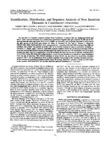
Figure 1: Seismic sequences and systems tracts determined by all-event tracking method.
Figure 2: Characteristics of seismic sequence boundaries including onlap, truncation, and concave incised valleys.
© 2010 SEG SEG Denver 2010 Annual Meeting
1547
Downloaded 12/20/12 to 222.66.175.193. Redistribution subject to SEG license or copyright; see Terms of Use at http://library.seg.org/
Sequence Analysis by All-reflector Tracking correspond to thick-bedded to massive braided fluvial sandstones, while the TST+HSTs are composed of relative strong reflectior sets, and correspond to lacustrine and marsh mudstones and coals.
boundaries. It has broad application potentiality in sequence stratigraphic analysis and reservoir characterization of small 3D seismic surveys. The only deficiency of the approach is time consuming, especially in manual horizon tracking.
Conclusions Acknowledgments All-reflector tracking method presented here provides an efficient approach to seismic sequence analysis in small 3D seismic surveys, in which the reflection terminations are not easy to identify, in order to achieve a high resolution and to avoid missing subtle seismic sequence
The authors would like to thank the Geophysical Prospecting Company of Chuanqing Drilling Engineering Co., Ltd., CNPC, China for their cooperation in preparing the abstract and for permission to publish this work.
Figure 3: Subdivision of seismic sequences and systems tracts by tying to well data via a synthetic seismogram.
© 2010 SEG SEG Denver 2010 Annual Meeting
1548
Downloaded 12/20/12 to 222.66.175.193. Redistribution subject to SEG license or copyright; see Terms of Use at http://library.seg.org/
EDITED REFERENCES Note: This reference list is a copy-edited version of the reference list submitted by the author. Reference lists for the 2010 SEG Technical Program Expanded Abstracts have been copy edited so that references provided with the online metadata for each paper will achieve a high degree of linking to cited sources that appear on the Web. REFERENCES
Hart, B., S. Sarzalejo, and T. Mccullagh, 2007, Seismic stratigraphy and small 3D seismic surveys: The Leading Edge , 26, no. 7, 876–881, doi:10.1190/1.2756867. Posamentier, H. W., and P. R. Vail, 1988, Eustatic controls on clastic deposition II-sequence and systems track models, in C. K. Wilgus, B. S. Hastings, C. A. Ross, H. W. Posamentier, J. C. Van Wagoner, C. G. Kendall, eds., Sea-level changes: an integrated approach: SEPM Society for Sedimentay Geology Special Publication 42, 125-154. Ramsayer, G. R., 1979, Seismic stratigraphy, a fundamental exploration tool: Offshore Technology Conference Proceedings, 1859-1867. Vail, P. R., and R. M. Jr, Mitchum, R. G. Todd, J. M. Widmier, S. Thompson.? J. B. Dangree, J. N. Bubb, W. G. Hatlelid, 1977, Seismic stratigraphy and global changes of sea level, in C. E. Payton, ed., Seismic stratigraphy - applications to hydrocarbon exploration: American Association of Petroleum Geologists Memoir 26, 49-212.
© 2010 SEG SEG Denver 2010 Annual Meeting
1549