External Grant Award Number 04HQGR0058
IMPROVED THREE-DIMENSIONAL VELOCITY MODELS AND EARTHQUAKE LOCATIONS FOR CALIFORNIA
Clifford H. Thurber University of Wisconsin-Madison 1215 W. Dayton St. Madison, WI 53706
Telephone: (608) 262-6027 FAX: (608) 262-0693 Email:
[email protected]
External Grant Award Number 04HQGR0058 IMPROVED THREE-DIMENSIONAL VELOCITY MODELS AND EARTHQUAKE LOCATIONS FOR CALIFORNIA Clifford H. Thurber University of Wisconsin-Madison 1215 W. Dayton St. Madison, WI 53706 Telephone: (608) 262-6027 FAX: (608) 262-0693 Email:
[email protected]
Abstract Our work focuses on the development of a three-dimensional seismic wavespeed model for the greater San Francisco (SF) Bay Area, in preparation for the centennial of the great 1906 San Francisco earthquake. The model will be used by others to compute strong ground motions in a simulation of the 1906 event, and it will help to characterize both well-known and hidden seismogenic structures. The model will also be used to derive improved absolute locations for northern California earthquakes. The dataset combines P-wave arrival times from a welldistributed set of about 7,000 earthquakes with a complete archive of available active-source (i.e., explosion) P-wave travel times from the region. The wavespeed modeling is being carried out with a combination of conventional and "double-difference" seismic tomography. The preliminary model covers the region west of the Great Valley from Hollister to Clear Lake. The geometries of the major faults are clearly defined by the relocated seismicity, and most of the seismogenic faults are marked by significant wavespeed features. Where the models overlap, our results are quite similar to those of Thurber [1983], Dorbath et al. [1996], and Eberhart-Phillips and Michael [1998], although in general our resolution of structure appears to be significantly improved. We attribute the improvement to the size of the dataset and the abundance of activesource data. We also identify a basement structure in the Fairfield-Vacaville area that is seismically active, apparently a buried thrust fault.
1
Project Results We have been working in collaboration with Tom Brocher of the USGS to assemble an activesource dataset that is as complete as possible for the northern California region, including some data that have never been utilized previously for seismic tomography. We have also extracted catalog phase arrivals for some of the larger shots recorded at the NCSN stations. That effort is essentially complete, including cross-checking of source and receiver coordinates and receivername rationalization across all experiments (plus the NCSN). A map showing the available active-source lines is presented in Figure 1.
Figure 1. Map of active-source (explosion and air-gun) surveys compiled by Tom Brocher and provided to this project. Integration and reformatting of these data have been carried out.
2
In parallel, we have extracted arrival-time data for about 7000 earthquakes that are optimally distributed throughout the current study region. We have compiled and merged all of these data and carried out a preliminary "conventional" tomography analysis using simul2000 [Thurber and Eberhart-Phillips, 1999], followed by double-difference (DD) tomography [Zhang and Thurber, 2003]. Preliminary inversion results are presented for our initial, slightly smaller study region, using about 6,000 earthquakes (Figure 2) and 5,500 shots/airgun blasts. The current model grid for the inversion uses 10 km spacing in the horizontal directions and gradually increasing grid intervals, from 1 to 5 km, in the vertical direction. We use a one-dimensional model from Hole et al. [2000] as our starting model. The inversion achieves an 80% variance reduction, bringing the final RMS residual to below 0.15 s.
Figure 2. Map of the earthquakes (circles) and layout of the inversion grid (crosses) for our preliminary inversion. Node spacing is 10 km in the horizontal directions, and grades from 1 km at the surface to 5 km at 15-20 km depth. Faults are shown as thin lines.
3
The preliminary model covers the region west of the Great Valley from Hollister to Clear Lake. The geometries of the major faults are clearly defined by the relocated seismicity, and most of the seismogenic faults are marked by significant wavespeed features. Where the models overlap, our results are quite similar to those of Thurber [1983], Dorbath et al. [1996], and EberhartPhillips et al [1998], among others, although in general our resolution of structure appears to be significantly improved. We attribute the improvement to the size of the dataset and the abundance of active-source data. Seismically active strike-slip faults with reasonable surface exposures predominate in the region, but we are also interested in faults or fault segments that are more challenging to characterize. Basement structures identifiable in gravity and magnetic data and in the wavespeed model appear to control the seismicity associated with the Ortigalita fault (which runs through San Luis Reservoir), an unmapped strike-slip fault connecting the Calaveras and Greenville faults, and an apparent thrust fault on the edge of the Great Valley near Vacaville. The latter feature is seismically active, and apparently is a buried thrust fault as evidenced by focal mechanisms (Figure 3).
Figure 3. Plot of focal mechanisms for earthquakes in the Fairfield-Vacaville area, showing a mixture of thrust, oblique, and strike-slip earthquakes. Source: NCEDC. 4
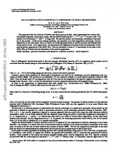
Figure 4 shows example cross-sections through our 3-D P-wavespeed (Vp) model. The locations of the cross-sections are shown in Figure 5. Starting in the southeast (Y = 50 km) in the vicinity of Gilroy, the San Andreas Fault (SAF) is well-defined as a steeply southwest-dipping plane of seismicity associated with high-Vp zone on the southwest side of the fault, consistent with the results of Thurber [1983]. The Sargent Fault (SF) and Calaveras Fault (CF) both cut obliquely across the section, so they appear as diffuse zones of seismicity. Moving northwest, the next section (Y = 80 km) passes through a portion of the Loma Prieta rupture zone. Here the SAF cuts obliquely through the section, so the SAF/Loma Prieta seismicity appears somewhat diffuse, although the steep southwest dip of the Loma Prieta rupture zone is evident. A low-Vp basin is adjacent to the SAF on its southwest side, and Vp is elevated at depth to the northeast of the Loma Prieta rupture zone, consistent with the results of Thurber et al. [1995], Eberhart-Phillips and Michael [1998], and others. The CF is sharply defined as a steeply northeast-dipping fault in this section, with a relatively deep low-Vp basin on its southwest side. The next section to the northwest (Y = 100 km) passes through the southern San Jose area. SAF seismicity is sparse, but the fault is marked by a high-Vp zone on its southwest side. The CF is still steeply dipping to the northeast, lying on the northeast edge of a high-Vp body. The beginnings of seismic activity on the southern Hayward Fault (HF) are visible. Moving further northwest, the next section (Y = 140 km) passes through Hayward. The HF is very clearly defined as a steeply northeast-dipping structure bounding a high-Vp body to the southwest. The CF and Greenville Fault (GF) cut somewhat obliquely across the section, but both appear to have a slight southwest dip. The SAF is virtually aseismic here. Finally, the northeastern-most section shown (Y = 170 km) passes through San Francisco peninsula and Berkeley. There is some activity on the SAF here, and the fault appears to be marked by a Vp contrast at depth (southwest side faster). The HF is a sharply defined vertical fault, also with higher Vp on its southwest side, consistent with Hole et al. [2000] and Zhang and Thurber [2003]. The Concord-Green Valley Fault (C-GVF) is also nearly vertical. To the northeast is the apparent buried thrust fault for which the focal mechanisms are shown in Figure 3 above. We are constructing a suite of higher-resolution tomography models using subsets of the data and the double-difference tomography method [Zhang and Thurber, 2003]. An example is shown in Figures 6 and 7 for the Hollister area. The model grid is 2 to 3 times finer in the southwestnortheast direction than the regional model discussed above, permitting an improved definition of basin and fault features. The double-difference technique also sharpens the seismogenic features substantially. In all sections, the SAF is associated with a high-Vp zone at depth to the southwest and a low-Vp basin to the northeast. Note the variation in SAF dip between the different sections. The Y = -20 km section, near Melendy Ranch, shows a nearly vertical SAF and relatively diffuse seismicity to the northeast. The Y = 0 km section, near Cienega Winery, also shows a nearly vertical SAF, but with well-defined activity on the Paicines-Calaveras Fault and the Quien Sabe Fault. The Y = 20 km section, near San Juan Bautista, shows a steeply southwest-dipping SAF. Seismic activity on the Busch and Sargent Faults cuts obliquely through the section, yielding a generally diffuse pattern of seismicity northeast of the SAF, bounded to the northeast by the steeply northeast-dipping CF. In summary, the geometries of the major faults are clearly defined by the relocated seismicity, and most of the seismogenic faults are marked by significant wavespeed features. Where the models overlap, our results are quite similar to those of Thurber [1983], Dorbath et al. [1996],
5
170
140
100
80
50 Figure 4. Cross-sections through the P-wavespeed model along NE-SW profiles. Countour interval for the P wavespeeds is 0.25 km/s. Earthquake hypocenters within 5 km of the section are indicated by circles. The number to the right indicates the Y value of the section (Figure 5). The white line surrounds the area of good model resolution. 6
Figure 5. Locations of the cross-sections through the P-wavespeed model shown in Figure 4.
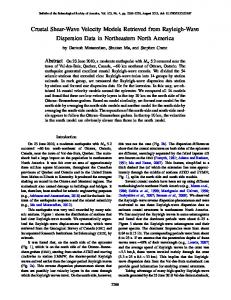
Figure 6. Map of the area of a higher-resolution model shown in Figure 7 derived with doubledifference tomography [Zhang and Thurber, 2003]. Stations are indicated by triangles, earthquakes by filled circles, and faults by thin lines.
7
Figure 6. Southwest-to-northeast sections through higher-resolution model derived with doubledifference tomography [Zhang and Thurber, 2003]. The SAF is associated with a high-Vp zone at depth to the southwest and a low-Vp basin to the northeast. Note the variation in SAF dip. Eberhart-Phillips and Michael [1998], and other studies, although in general our resolution of structure appears to be significantly improved. We attribute the improvement to the size of the dataset and the abundance of active-source data. We also identify a basement structure in the Fairfield-Vacaville area that is seismically active, apparently a buried thrust fault. References Dorbath, C., D.H. Oppenheimer, F. Amelung, and G.C.P. King, Seismic tomography and deformation modeling of the junction of the San Andreas and Calaveras faults, J. Geophys. Res. 101, 27,917. 1996. Eberhart-Phillips, D., and A.J. Michael, Seismotectonics of the Loma Prieta, California, region determined from three-dimensional Vp, Vp/Vs, and seismicity, J. Geophys. Res. 103, 21,099, 1998. Hole, J. A., T.M. Brocher, S.L. Klemperer, T. Parsons, H.M. Benz, and K.P. Furlong, Threedimensional seismic velocity structure of the San Francisco Bay area, J. Geophys. Res. 105, 13,859, 2000. Thurber, C.H., Earthquake locations and three-dimensional crustal structure in the Coyote Lake area, central California, J. Geophys. Res., 88, 8226, 1983. Thurber, C. H., S. R. Atre, and D. Eberhart-Phillips, Three-dimensional Vp and Vp/Vs structure at Loma Prieta, California, Geophys. Res. Lett., 22, 3079-3082, 1995. 8
Thurber, C., and D. Eberhart-Phillips, Local earthquake tomography with flexible gridding, Comp. & Geosci., 25, 809, 1999. Zhang, H., and C.H. Thurber, Double-difference tomography: method and application to the Hayward fault, California, Bull. Seismol. Soc. Am., 93 1875, 2003.
Bibliography Thurber, C., H. Zhang, V. Langenheim, and T. Brocher, Geophysical characterization of seismogenic structures in northern California, Eos Trans. AGU, 85(47), Fall Meet. Suppl., Abstract S51D-01, 2004.
9