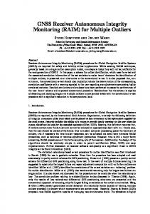
server via communication devices. A new MS SQL database has ... GIS functions are realized using ESRI ArcGIS software. An ArcGIS ... long-term continuous landslide monitoring (Bazin 2012). A major ... Figure 2 GNSS monitoring and sensor data transfer to server. ... Construction of the City, Utility Services and Transport).
Geographic Information System of the Kostanjek Landslide: Integration of Real-time GNSS Monitoring Data with other Sensor Data Martina Baučić(1), Snježana Mihalić Arbanas(2), Martin Krkač(2) 1) University of Split, Faculty of Civil Engineering, Architecture and Geodesy, Split, Croatia; Geodata d.o.o. Split, Croatia, Kopilica 62, +385 21 490497 2) University of Zagreb, Faculty of Mining, Geology and Petroleum Engineering, Zagreb, Croatia
Abstract The Kostanjek landslide monitoring system consists of more than 40 sensors permanently installed at the more than 20 locations in the field: (1) sensors for displacement measurement (GNSS receivers, short- and long-span extensometers); (2) sensors for hydrological measurements (rain gauge, outflow weirs, water level sensors, piezometers); and (3) sensors for geophysical measurements (accelerometers). This paper shortly presents concept of the Geographic information system (GIS) of Kostanjek landslide which has been developeing with the primary objective: integration of real-time GNSS monitoring data with other sensor data. To integrate and visualize GNSS monitoring data, GIS is connected to MS SQL database and it reads GNSS data, transferred to server via communication devices. A new MS SQL database has been created for storing measurement data, and new application has been developed for import and geolocating data which are transferred to server manually. To integrate and visualize sensor data, GIS is connected to sensor database in MS SQL database. The GIS functions are realized using ESRI ArcGIS software. An ArcGIS comprehensive map is created and it shows topographic data, landslide features, GNSS monitoring data and sensor data. The users can use all the ArcGIS functions for creating their own maps and analyze data. The main advantage of data integration into one GIS system is to enable consistent and reliable framework for long-term archiving of all types of data which will be used in further analyses. Keywords Kostanjek landslide, landslide monitoring system, monitoring data integration, GNSS, GIS
moving landslide moving at a velocity of up to 44 cm/year, which was maximum velocity reached in the period 1974-1976 according to Ortolan (1996). Catastrophic failure of the landslide mass would 2 endanger urbanized area with total size 1,2 km . Because of the size of the moving landslide mass, remedial engineering measures are prolonged for 50 years till now. Consequently, the landslide risk must be managed by implementing an effective early warning system based on long-term continuous landslide monitoring (Bazin 2012). A major monitoring and early warning program were begun at the Kostanjek landslide in 2011 in the frame of the scientific joint-research bilateral Croatian-Japanese SATREPS FY2008 project (Mihalić and Arbanas 2012). Monitoring can be generally defined as the systematic repetition of observations of a particular object or area (Fig. 1). Landslide monitoring in particular comprises a number of different tasks that will influence the choice of the optimal technique which can be applied to landslide detection, fast characterization, rapid mapping and long-term monitoring (Stumpf et al. 2011). The objective of Kostanjek landslide monitoring is longterm monitoring which implies processing data for retrieving deformation patterns and time series. Longterm monitoring of the Kostanjek landslide is necessary, because it was identified as active landslide in the last 50 years (in 1963) and repeated activity in the future has to be anticipated. Long-term monitoring of the Kostanjek landslide is required to: i) implement an early warning system; ii) to validate the kinematic model formulated for the landslide 17 years ago (Ortolan 1996); iii) to check the effectiveness of the stabilization or other remedial measures and, once they will be applied.
Introduction The Kostanjek landslide is located on the south hills of Medvednica Mt. in western part of the Zagreb city. It 3 has an estimated volume of up to 32.6 Mm and is slow
Figure 1 Definition of monitoring as the systematic repetition of observations (Stumpf et al. 2011).
Figure 2 GNSS monitoring and sensor data transfer to server.
The Kostanjek landslide monitoring system has been establishing from 2011. Assessments over large landslide area (total size of the Kostanjek landslide is 1,2 2 km ) require consequently the installation of networks composed of many instruments, and the accomplishment of a field work in which many traditional measures are performed at many discrete points. According to the list of 15 European landslides for which real data collection and analysis is established (published in Baron et al. 2012), this site belongs to 3 the biggest one. The core of the monitoring system consists of 15 GNSS reference stations (dual frequency), 9 long- and short-span wire extensometers, 1 inclinometer, 4 vertical wire extensometers, 3 piezometers in one borehole up to 70 meters deep, 1 rain gauge, 3 water level sensors and 5 accelerometers (Mihalić Arbanas et al. 2013). Among observations using instruments installed at the landslide site, there are numerous periodical monitoring of ground water level in wells, discharge measurement in superficial streams etc. (Krkač et al. 2013). As a result, the costs and the time needed to gather the required amount of data may increase dramatically. Moreover, the possibility to focus on data that show signs of activity (e.g., places of larger displacements or increased velocities etc.) can be crucial for practical applicability of the system. This paper summarizes the concept of the geographic information system (GIS) of Kostanjek landslide which has been developed with the primary objective of integration of real-time GNSS monitoring data with other sensor data. There are 15 GNSS monitoring stations with real-time data transfer to server,
and more than 20 sensors with manual data transfer (Fig. 2). The server for landslide data and applications resides at Faculty of Mining, Geology and Petroleum Engineering in Zagreb. The prerequisite for integration was to establish GIS connection to GNSS monitoring data and to store, read and geolocate measurements data from all sensors.
Geographic information system of Kostanjek landslide At first, the broader information system architecture has been designed. The main users, functions and subsystems are identified. The main groups of users are: Faculty of Mining, Geology and Petroleum Engineering in Zagreb, local government (Emergency Management Office of the City of Zagreb and City Office for Physical Planning, Construction of the City, Utility Services and Transport) and regional government (National Protection and Rescue Directorate of the Republic of Croatia), contracted companies and scientific public. The four subsystems are: GNSS monitoring, Sensor data, GIS and Alerting. The identified GIS subsystem functions are: storing geodata, integrating and visualizing geodata from other subsystems, geo-analyzing, preparing views and downloads. GNSS monitoring subsystem The GNSS monitoring subsystem consists of 15 GNSS monitoring stations installed at 15 fixed poles at the 2 Kostanjek landslide area of 1,2 km . The GNSS monitoring stations are equipped with communication devices for
Figure 3 GIS layers.
automated data transfer to server (Fig. 3). MS SQL database and complex Trimble T4D monitoring software reside on server. T4D manages with GNSS data in SQL database and performs GNSS station set-up, data collection, transfer, storage, processing, analyze, viewing and alarming. Today, the following measurements are present in the GNSS Monitoring Subsystem: • RTK, unfiltered • RTK, filtered (weighted mean 30 min) • RTK, filtered (weighted mean 2 hours) • Post-processing 1 hour • Post-processing 24 hours. The GNSS Monitoring Subsystem allows changes and adding of new types of processed GNSS data. To integrate and visualize GNSS data, GIS is connected to MS SQL database and it reads GNSS data.
inclinometer, 7 accelerometers, 4 water level sensors and 1 rain gauge. Data are stored in sensor specific device (e.g. data logger, memory card), and using sensor specific data format and structure (e.g. CSV file format). Measurements data is now exported from the sensor manually, by copying file from sensor data logger or memory card to server. To enable data integration and GIS connection to sensor data, various sensors data formats and structures are converted in one data model of standard relational database. There are three main entities in the data model: sensor, location and measurement. Therefore, a new MS SQL database has been created for storing sensor data, and an application has been developed for import and geolocating. To integrate and visualize sensor data, GIS is connected to sensor database in MS SQL database.
Sensor data subsystem
Geographic information subsystem
Sensor data subsystem contains different types of measurements coming from geodetic, geotechnical and hydrological sensors covering more than 50 locations at the area of the Kostanjek landslide: 37 stable geodetic points temporarily measured by GNSS; 9 extensometers, 1
The main GIS functions are: • storing landslide geographic and geolocated data • integrating and visualizing topographic, landslide, GNSS monitoring and sensor data, by showing on map in common geographic reference system
Figure 4 ArcGIS map. •
geoanalyze landslide data preparing views and downloads for users (via eservices). An initial GIS database is created and stored on server. The GIS layers are shown on Figure 4. The GIS subsystem functions are realized using ESRI ArcGIS software. An ArcGIS map is created and it shows topographic data, landslide features, GNSS monitoring data and other measurements data. The users can use all the ArcGIS functions for creating their own maps and analyze geodata. •
Achievements In this paper, the development of GIS of landslide Kostanjek has been described. GNSS and other sensor data are integrated and visualized. Data from various sensors in specific data structures are now stored in one data model in MS SQL database. The improvement of existing system will be to automatically transfer data from the sensors to the server. Thus, the system will have access to real time sensors
data what is crucial for implementation of an effective early warning system. In order to achieve this it is necessary to add communications equipment to each sensor, and to install an application to server that will import and store measurements in a database. The effort described here has proved all the complexity of collecting different types of data for landslide characterization and monitoring. There are also additional types of data collected from time to time (e.g., seasonally) by sampling in the field (e.g., water level measurement, chemical and mineralogical content of water, rock and soil etc.). Here, we coped only with data and all its heterogeneity. As Kandawasvika (2009) stated: ‘The major problem is how to integrate or manage simultaneously these various, heterogeneous sensors within that single application space’. The main advantage of data integration into one GIS system is to enable consistent and reliable framework for long-term archiving of all types of data which will be used in further analyses. Most of monitoring parameters of the Kostanjek landslide monitoring system can be grouped as follows: slope movement/deformation/activity
Proceedings of the 1st Regional Symposium on Landslides, Zagreb, 2013
(displacement); hydrologic properties (ground water level/pore-water pressure, water balance, inflow and outflow, surface flow; surface and subsurface water quality); external triggers (meteorological conditions and seismicity/earthquakes). We hope that we will continue with analysis. Landslides are dynamic features of reality, and as such require advanced models of spatiotemporal data, spatiotemporal analysis and spatiotemporal reasoning.
Acknowledgments Results presented herein have been obtained with the financial support from JST/JICA’s SATREP Program (Science and Technology Research Partnership for Sustainable Development). This support is gratefully acknowledged. We would like to express our very great appreciation to the company Geomatika- Smolčak Ltd., Trimble Germany and Geodata Ltd. for consultations during the planning and development of the system. Our special thanks are extended to our colleagues Mr. Nenad Smolčak, Ms. Daniela Koch and Mrs. Daniela Staničić for their support during the work.
References (in the alphabetical order) Baroň, I, Supper, R, Ottowitz, D, (2012) Report on evaluation of mass movement indicators. SafeLand deliverable D4.6. Geological Survey of Austria. Vienna, Austria. 382p. Bazin, S, (2012) SafeLand guidelines for landslide monitoring and early warning systems in Europe - Design and required technology. Geophysical Research Abstracts, Vol 14, EGU20121347-2, EGU General Assembly. Kandawasvika, A, (2009) On Interoperable Management of MultiSensors in Landslide Monitoring Applications. PhD thesis, The Universität der Bundeswehr München, Germany. Mihalić, S, Arbanas, Ž, (2012) The Croatian–Japanese Joint Research Project on Landslides: Activities and Public Benefits. In Sassa K et al (eds). Landslides: Global Risk Preparedness, Springer-Verlag. (ISBN: 978-3-642-22086-9). pp. 335-351. Mihalić Arbanas, S, Arbanas, Ž, Krkač, M, (2013) TXT-tool 2.385-1.2 A comprehensive landslide monitoring system: The Kostanjek landslide, Croatia. In Sassa K et al (eds). ICL Landslide Teaching Tool, ICL, Kyoto, Japan. (ISBN: 978-4-9903382-2-0). pp. 158-168. Krkač, M, Rubinić, J, Kalajžić, J (2013) Analysis of water fluctuation dynamics in the wider area of the Kostanjek landslide. st Proceedings of 1 ICL ABN Regional Symposium on Landslides, 6-9 March 2013. Emergency Management Office of the City of Zagreb, Croatia. In press. Ortolan, Ž, (1996) Development of 3D engineering geological model of deep landslide with multiple sliding surffaces (Example of the Kostanjek Landslide). PhD thesis, Faculty of Mining, Geology and Petroleum Engineering, University of Zagreb, Zagreb, Croatia (In Croatian). Stumpf, A, Kerle, N, Malet, JP, (2011) Guidelines for the selection of appropriate remote sensing technologies for monitoring different types of landslides. SafeLand deliverable D4.4. Faculty for Geo-information Science and Earth Observation – ITC and University of Twente, United Nations University. Netherland. 91p.
5