Special Issue—Bathymetry from Space
Introduction to This Special Issue on Bathymetry from Space
How many of our readers, before picking up this issue, would have said bathymetry is an integral part of oceanography? An old New Yorker cartoon has someone remark, “I don’t know why I don’t care about the bottom of the ocean, but I don’t.” This issue of Oceanography is full of good reasons to care. Some years ago, oceanographers were implicitly taught to ignore the ocean bottom. The classical method for estimating surface currents from water temperature and salinity assumes a “level of no motion.” Flow at depth was taken to have negligible influence on ocean structure or surface currents, and was assumed to be zero. New science shows just how wrong that assumption is. Satellite observations of surface currents and tides reveal that bottom topography has significant influence on the steering of currents and the dissipation of energy. As computing power increases, numerical ocean models employ increasingly realistic physics with increasing sensitivity to these bottom effects. Gille et al. review how topography steers currents and influences circulation, in the real ocean and in models. Kunze and Llewellyn Smith review the many ways in which bottom slope and roughness increase and localize mixing and energy dissipation. Jayne et al. examine the chain of connections from bottom topography through mixing and transport to climate change and sea-level rise. Taken together, these papers show that ignorance of the bottom means infidelity to the true workings of the ocean, and that a realistic global change research program must be founded on detailed bottom topography. Globally uniform and detailed bathymetry is basic infrastructure, a prerequisite for intelligent scientific, economic, educational, managerial, and political work, in fields such as resource exploration, habitat conservation, and the planning of communications cable and pipeline routes. This special issue highlights two important topics with political, economic, and human dimensions. Monahan reviews the application of bathymetry from space to the mapping of new seabed territorial claims under the Law of the Sea. Vast areas are at stake, with the potential resource value to the United States alone in the trillions of dollars. Mofjeld et al. look at the tsunami and seismic hazards to coastal
communities, examining the role that deepwater bathymetry plays in focusing or diffusing tsunami energy, and in revealing areas of the ocean floor that are likely to break out in new earthquake faults. Many people have seen a map of the ocean basins, and naturally might assume that such maps are accurate and adequately detailed. People are usually astonished to learn that we have much better maps of Mars, Venus, and Earth’s moon than we have of Earth’s ocean floors. Public opinion polls find that people in the United States favor ocean exploration over space exploration by two to one, yet there is no steady and systematic effort at mapping our home planet’s oceans. Bathymetric survey tracks cover the remote oceans as sparsely as the Interstate Highway System covers the United States. Imagine, for a moment, producing a topographic map of the United States using only data collected along the interstate highways. How would you interpolate the gaps? What features would you miss? How would this handicap our understanding of U.S. geology, environment, and resources? A bathymetric survey of the deep ocean would take about 200 years of ship time at a cost of billions of dollars; shallow water areas would take more time and money. Satellite radar altimetry provides a reconnaissance of oceans that is orders of magnitude faster and cheaper, although it also has lower resolution than state-of-the-art acoustic bathymetry. Satellites cannot sense ocean depths directly, but they can measure ocean surface tilts produced by anomalies in Earth’s gravity field. A well-designed altimeter mission can map the global marine gravity field uniformly to a high precision. This gravity mapping is directly useful for correcting errors in inertial navigation systems and for geological exploration. The satellite altimetric gravity data may also be combined with the sparse bathymetry now available to infer the topography of the ocean floor. This is what we mean by “bathymetry from space.” Smith and Sandwell review ocean mapping by conventional and space-based means, and why it is that an altimeter mission designed to map bathymetry and gravity is different from missions such as Topex/Poseidon, Jason, and EnviSat, which are
Oceanography • Vol. 17 • No. 1/2004
6
This article has been published in Oceanography, Volume 17, Number 1, a quarterly journal of The Oceanography Society. Copyright 2003 by The Oceanography Society. All rights reserved.Reproduction of any portion of this article by photocopy machine, reposting, or other means without prior authorization of The Oceanography Society is strictly prohibited. Send all correspondence to:
[email protected], or 5912 LeMay Road, Rockville, MD 20851-2326, USA.
Walter H.F. Smith Guest Editor NOAA Laboratory for Satellite Altimetry • Silver Spring, Maryland USA
designed to observe tides, currents, El Niño, and other phenomena. Goff et al. probe the ultimate resolution of bathymetry from space by examining the background texture of altimetric map data. On the real ocean floor, the background texture is quasi-fractal and is made up of abyssal hills. The size of these varies from place to place in the ocean, primarily as a function of seafloor spreading rate. Goff et al. find that existing altimeter data can reveal the influence of the larger seafloor hills on the altimetric map texture, and that a new mission achieving a factor of four lower noise level would be able to map the orientation of hills of all sizes. This would allow extrapolation of seabed roughness statistics down to very fine scales, due to the shape similarity properties of fractals. This special issue was stimulated by a workshop convened by Dr. David T. Sandwell, Dr. Sarah T. Gille, and myself at the Scripps Institution of Oceanography
in October of 2002. I am grateful to Dr. Ellen Kappel, Editor of Oceanography, and Jennifer Ramarui, Executive Director of The Oceanography Society, for the invitation to guest-edit this special issue, and for their assistance and logistical support. I also thank Dr. Marie Colton, Director of the Office of Research and Applications, National Environmental Satellite Data and Information Service, National Oceanic and Atmospheric Administration, who underwrote production and distribution of this special issue. The views, opinions, and findings contained in this report are those of the authors and should not be construed as an official National Oceanic and Atmospheric Administration or U.S. Government position, policy, or decision.
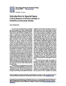
Earth vs. Mars: Mapping the Surface of Planets from Space
Ocean Floor
Mars
The surfaces of Mars, Venus, and the Moon are much better mapped than Earth’s ocean floors. Topography of Earth’s MidAtlantic Ridge (left) derived from sparse ship soundings and satellite altimeter measurements reveals the large-scale structures created by seafloor spreading (ridges and transforms) but the horizontal resolution (15 km) and vertical accuracy (250 m) is poor. Topography of Valles Marineris on Mars (right) reveals both the large-scale structure of the canyon as well as the smaller impact and fracture features. These images have the same horizontal and vertical scale. The horizontal resolution of the Mars data (1 km) is 15 times better than that of the Earth data, while the vertical accuracy (1 m) is 250 times better.
Oceanography • Vol. 17 • No. 1/2004
7