Is there a link between fractal dimension and reside...
http://www.cybergeo.eu/index16283.html
Cybergeo Systèmes, Modélisation, Géostatistiques
Isabelle THOMAS, Cécile TANNIER et Pierre FRANKHAUSER
Is there a link between fractal dimension and residential environment at a regional level? Existe-t-il un lien entre dimension fractale et environnement résidentiel à l'échelle régionale ?
article 413
ABSTRACT/RÉSUMÉ Fractal dimension is used to measure the spatial arrangement (morphology) of built-up areas within a Nuts1 region (Wallonia, Belgium) and, more particularly, to test to what extent fractal dimension is related to some variables commonly used in urban economics/urban geography to characterise built environment, housings and residential choice (such as land price, housing rentals, history of urbanisation, type of housing). Special attention is put on the link with the perception of the built environment by households. A multivariate analysis concludes the paper. It is shown that fractal indices differ from other indicators and are very useful for characterising and understanding built landscapes, as well as for modelling and planning urban realities. La dimension fractale est utilisée pour mesurer la répartition spatiale (morphologie) des espaces bâtis au sein d'une région Nuts1 (Wallonie, Belgique). Plus particulièrement, on cherche à tester l'intensité de la relation entre la dimension fractale et d'autres variables habituellement utilisées en économie et géographie urbaines, pour caractériser le choix résidentiel, les logements et l’espace bâti en général (prix foncier, rente foncière, histoire de l'urbanisation, types de logements...). Une attention particulière est portée sur la relation entre dimension fractale et perception, par les ménages, de la qualité de l'environnement bâti. L'article se termine avec une analyse multivariée qui montre que les indicateurs fractals utilisés diffèrent d'autres indicateurs et sont utiles pour caractériser et comprendre les paysages bâtis urbains, ainsi que pour modéliser et aménager les espaces urbains.
PLAN Introduction Data and methodology Built-up areas Socio-economic data Methodology Computing fractal indices Computing fractal indices on dilated realities Results Exploratory data analysis
1 sur 24
06.05.2008 15:50
Is there a link between fractal dimension and reside...
http://www.cybergeo.eu/index16283.html
Bivariate relationships Morphology and density Morphology and history Fractal dimension and type of building Morphology and rents Morphology and perception of the habitat A multivariate synthesis Conclusion TEXTE
Introduction 1
It is well known that there is a great diversity of morphologies of built-up areas at a regional level, and that the patterns are influenced by a large variety of factors and processes such as natural site conditions, agricultural traditions, historical context, social development, technological context, accessibility as well as economic forces and/or land-use planning rules, which intertwine in a complex system (see e.g. Milne, 1991; McGarigal and Marks, 1995;Antrop, 1997; 2000; 2006; Antrop and Van Eetvelde, 2000; Allain, 2005). Built-up patterns also result from the evolution over time of these components. Historically the most important change imposed by humans on the landscape in a country like Belgium was the clearing of forest for agricultural purposes. Hence, villages were traditionally very compact. Subsequently, commerce, industrialisation and transportation, together with the growing population, have increased human’s need and ability to shape the environment according to our requirements. Belgian geographers traditionally define four types of urban level, mainly by density values and commuting patterns: urban centre, suburban fringe, rural countryside around the urban network, and remote rural countryside (Van der Haegen et al. 1996). At each of these levels the driving forces in terms of accessibility, urbanisation and globalisation are active in different ways (Antrop and Van Eetvelde, 2000).
2
Our aim here is to analyse the spatial arrangement of individual buildings (built-up patterns) and to see how they vary within the region being studied. We are also interested in how far the form of the built environment corresponds to the history of urbanisation and to residential tastes. We suspect that common life styles, planning rules, architectural choices, etc. may lead to similar built-up patterns. More specifically, the paper aims at testing two main hypotheses:
3
- Fractal dimensions allow a synthetic description of the built environment of each commune. By considering this hypothesis, we ask questions about the specificity of the fractal indices: are the computed fractal indices unique, or are they highly correlated to other measures commonly used in urban geography and economics for describing the built environment at this level of analysis? Four variables are considered, each of them throwing light on an aspect of the built environment of each commune: population density, distance to the closest CBD (commercial and business district), type of housing, and the date of construction.
4
- Fractal dimensions can be used to evaluate the quality of the built environment of each commune. More precisely, we hypothesise that the multi-scale organisation of a built-up area reveals the good qualities of that environment from a functional (not an aesthetic) point of view. This hypothesis stems from the argument developed by Cavailhès et al. (2004), which suggests that a set of fractal forms allows the optimisation of the accessibility of various amenities, including
2 sur 24
06.05.2008 15:50
Is there a link between fractal dimension and reside...
http://www.cybergeo.eu/index16283.html
green and rural amenities as well as urban amenities (retail and services). Even if not all fractal forms allow optimal access to all types of amenities, it seems realistic to suppose that the multiscale organisation of a pattern favours good access to various amenities, which can be used as an indicator of a good built environment from a functional point of view. In order to test this hypothesis, we explore the statistical relationships between three selected fractal indices and two socio-economic indicators of the quality of the built environment: land rent (on the assumption that the higher the quality of the built environment, the higher the land prices), and median income of households in each commune (on the assumption that the higher the quality of the built environment, the higher the median income of households in that commune). 5
The built environment can also be considered from an aesthetic point of view. In each commune, the evaluation of the quality of the built environment from a functional perspective is consistent with the mean evaluation of the aesthetic quality of the residential environment of each building. There are two points of view on the question of landscape evaluation: one considers the landscape as it is seen (and thus perceived) from each building in a studied area (see e.g. Paterson and Boyle, 2002; Cavailhès and Joly2006); the other considers landscape quality as a global characteristic of an area (e.g. Geoghegan et al., 1997; Kestens et al., 2004). Our goal here is to find an argument that could help to link these two points of view together.
6
In order to position this paper in a more general scientific context, two points should be considered. First, this paper is related to research in geography, urban economy and urban planning, that aim to link urban forms and other socio-economic variables such as social equity, quality of life, and access to facilities, jobs and green spaces. This field of research has been explored especially in the context of the debate about the compact city. To give only two examples, statistical relationships between form indicators and social/environmental variables can be found in Burton (2000), and the relationship between form and the perception of their environment by individuals is explored in Garcia and Riera (2003). Second, this paper represents a contribution to the use of spatial metrics for the analysis of urban environments, as developed for example by Alberti & Waddell (2000), Parker & Meretsky (2004) and Herold et al. (2002). This paper hopefully takes one more step towards the demise of the use of spatial units that are composite from a morphological point of view.
7
The data used in this paper only covers the southern part of Belgium (Wallonia) and is different from that used in companion papers. Thomas et al. (2007b) studied the southern periphery of Brussels (Nuts3 region) with a particular concentration on the effect of the size and shape of the units as well as the meaning of fractality compared to density. A first, very exploratory, attempt at linking fractal dimension to socio-economic variables was made by De Keersmaecker et al. (2004). Another paper by Thomas et al. (2008) studies the same set of Walloon communes as those analysed in the present paper, but it focuses on a new technique for clustering fractal dimensions. Empirically, it shows that fractal indices partition the region into six sub-areas that do not correspond to the “natural landscapes”; no other variables are considered. These earlier papers help to orient the empirical and methodological choices which inform this article.
8
This paper is organised as follows. Section 2 gives a step-by-step explanation of the method used; variables are selected and justified, and the area being studied is roughly described. Section 3 gives the results in terms of exploratory data analysis, bivariate and multivariate analysis. Section 4 concludes the paper.
Data and methodology 3 sur 24
06.05.2008 15:50
Is there a link between fractal dimension and reside...
http://www.cybergeo.eu/index16283.html
Built-up areas 9
Empirical analyses are conducted here on the southern part of Belgium, which corresponds to a Nuts1 region: Wallonia. It covers 16,845 sq. km., has 3.4 million inhabitants and is administratively divided into 262 communes (or townships). Each commune is made up of several villages: before 1977, these villages formed communes, which were then merged into larger administrative units. Hence, the built-up area of a commune often consists, nowadays, of a juxtaposition of several independent morphological sets, which has to be taken into account when interpreting the results of the analyses. We here decided to work at the communal level mainly because (1) in periurban areas sprawl has made the former villages to merge, and (2) some data are not available by former villages (land rent, etc). We are aware that the choice of the scale of analysis influences the results and that the size and shape of the communes vary.
10
The PLI (Plan de Localisation Informatique) developed by MRW-DGATLP (2004) was used to compute fractality; it is based onthe digitised topographical maps at a scale of 1:10 000 (IGN, Institut Géographique National) and the land register (cadastre). This database is updated annually and is available by commune. The built-up areas correspond to a vectorial layer of information where buildings are individually identifiable. It was rasterised in order to obtain a binary image in which each built-up pixel represents a 21 by 21 metres zone that is fully or partially occupied by a building or part of a building. No information is provided about the function of the pixels (residence, public service, industry, service or farm), the height of the buildings, their architectural characteristics or their occupants (i.e. the number of inhabitants or the number of jobs located within a pixel).
Socio-economic data 11
As well as the morphological data, census data were collected for each commune (Data produced by the I.N.S., Institut National de Statistique). The choice of census data was based on models commonly used in spatial analysis (geography, economics) as well as on the hypotheses discussed in Section 1. Appendix 1 gives the main statistical descriptors of these variables for the area being studied. Hence, the values of the fractal dimensions will be compared to:
12
Population density (here called Density) is expressed as the number of inhabitants divided by the total area of the commune. It has already been demonstrated that fractal dimension is not synonymous with density (Batty and Xie, 1996; Thomas et al., 2007b, 2008), but we expect the correlation to be positive. This hypothesis stems from two observations: on the one hand, high densities are often synonymous of quite regular built-up morphologies; on the other hand, density is often pretty high in the some communes of Wallonia.Previous research has already discussed the subtle link between fractal dimension and density (Thomas et al, 2007b; Burton, 2000).Density will also here be considered as a control variable: we analyse the fractal dimension for some ranges of density values.
13
- It is common knowledge in urban analysis that the further we go from the CBD, the larger the residential plots become and the lower the density. History has led to very dense and homogeneous city centres where no or very few plots of land are still available for construction, and to sprawling peripheries (see e.g. Burton, 2000; Allain, 2005). Urban sprawl is characterised by a loss of multiscale characteristics of the built-up areas at a local analysis level. But, at a more global analysis level, the peri-urban built-up patterns in Wallonia remain very contrasted. Hence, we expect that the higher the distance from a city-centre, the lower the value of D 1. Heterogeneity will increase with distance from the CBD. Distance is here measured as the
4 sur 24
06.05.2008 15:50
Is there a link between fractal dimension and reside...
http://www.cybergeo.eu/index16283.html
straight-line distance between the centroid of each commune and its closest CBD 2. The road network is so tight that a straight-line distances is a sustainable assumption (Vandenbulcke et al., 2007). 14
- Some characteristics of the morphology of dwellings are also available in the 2001 Population and Housing Census. The type of housing is of major interest for us. For each commune we computed: the percentage of households living in an apartment (Apartments), in terraced houses (attached on both sides, called Terraced), in detached houses (Detached), and in semi-detached houses (attached on one side, Semis). A priori we expect that a large percentage of terraced housing corresponds to a ribbon-like morphology, while a large percentage of fully detached houses leads to a diversity of morphologies depending on the land-use planning rules or fashion. Indeed, detached houses can be the result of strong planning rules and hence homogeneous plots, or, on the contrary, to loose planning rules and hence quite heterogeneous housing styles.
15
It also seems logical to assume that the morphology of the buildings will depend upon the year of development/peri-urbanisation (i.e. on the history of urbanisation). Hence, census information on the date of construction of the buildings was used. Percentages are computed without taking missing values into account (Thomas and Vanneste, 2007). Hbef1919 represents the percentage of dwellings built before 1919, H1946-1970 the percentage built between 1946 and 1970, H1971-1980 the percentage built between 1971 and 1980, H1981-1990 the percentage built between 1981 and 1990, and H1991-2000 the percentage of dwellings built between 1991 and 2000. We expected recent construction to characterise new suburbs, and hence more heterogeneous built-up areas. High percentages of old buildings are often typical of historical centres (Vanneste et al., 2007).
16
From a socio-economic perspective, we also tested whether people pay more to live in a more heterogeneous built environments (see Cavailhès and Joly, 2006; Burton, 2000). The multi-scale aspect of residential environment has an impact on land prices. We first considered the price of a square meter of land (Landprice), which was computed using the Stadim data. These data are privately owned and do not include the highest and lowest quintile; the average value of the remaining three quintiles was computed for three years (1999, 2000 and 2001). Land is limited to “building land” that was sold within that period. Another variable used for evaluating land prices was the average price of plots of land between 360 and 720 sq. m large that were sold during the same period of time (PricePlot) (same data source). Average house prices are difficult to consider, because we have no information on the size and quality of the house that was sold: the average value can include very small houses on a large plots, as well as luxury mansions on small plots. We know that in Belgium, land prices and house rentals are not well correlated (Thomas and Vanneste, 2007): land prices depend on the pressure on land, while rents are dominated by Brussels which is the largest city. Hence, we here also consider the percentage of dwellings with a monthly rent greater than 750 euros, whatever the type of housing (Highrental) (Source: 2001 Census). Last but not least, the household’s median income (Income) was also considered. This is a measure of welfare, but also a proxy of “human capital” (Thisse and Thomas, 2007). In Belgium rich people prefer to live in communes where built-up and other areas are multi-scaled.
17
Last but not least, one of the original features of the 2001 Census, is that one question covered the perception of the environment. Each head of household had to judge his/her environment as pleasant, decent or unpleasant in several respects. Here we only consider the aesthetic of the buildings around the house and created the variable “percentage of households that were not pleased with their built environment” (Unpleasant). We wanted to test the quality of life, the happiness of the inhabitants with their neighbouring built environment. This taps into the interaction between nature/landscape, cultural history and inhabitants. The scenic quality is
5 sur 24
06.05.2008 15:50
Is there a link between fractal dimension and reside...
http://www.cybergeo.eu/index16283.html
considered as an important characteristic (Antrop, 2006; Burton, 2000). This is perhaps the most interesting/original part of the analysis. The underlying question is the relationship between the assessment of the environment by the survey, and by the fractal indices. How far do they reveal the same trend?
Methodology 18
In this section we explain some general fractal concepts practically and intuitively, and show how they fit with our objectives. For extensive mathematical formulations, we refer the reader to Mandelbrot (1982), Batty and Longley (1994), Frankhauser (1994; 1998), Lam and de Cola (2002) and Mattila (1995).
Computing fractal indices 19
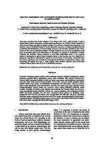
Let us take the example of a commune located in the southern part of Wallonia:Arlon, 119 square kilometres and 26 000 inhabitants. The built-up area in Figure 1 (top) shows quite an agglomerated city in the centre of the image, surrounded by several star-shaped villages with urbanisation along the transportation axes.
Figure 1: Arlon: Original built-up areas (top), dilated built-up areas (bottomleft) and borders (bottomright)
Source: Plan d’Information Informatique (P.L.I.), 2002 20
Three fractal dimensions can be computed: the fractal dimension of the built-up areas (denoted DSurf-dil0), the fractal dimension of the dilated built-up areas (DSurf-dil3), and the fractal dimension of the border of the dilated built-up areas (DBord-dil3). From experience we know that the combination of these three indices yields a good characterisation of the built-up form of each commune (see Thomas et al., 2008). All the dimensions were computed by means of correlation analysis:each
6 sur 24
06.05.2008 15:50
Is there a link between fractal dimension and reside...
http://www.cybergeo.eu/index16283.html
pixel belonging to the built-up area is surrounded by a small square window of size ε. The number of built-up pixels within each window is enumerated. This allows the mean number of pair correlations N(ε) per window of that size to be computed. The operation is repeated for windows of increasing size This results in a series of points that can be represented on a Cartesian graph where the X-axis represents the size of the window ε = (2i+1), where i isthe iteration step, and the Y-axis represents the mean number of points counted per window.
Figure 2: Screen print of the DSurf-dil0 estimation by Fractalyse X-axis = size of the analysis window (number of pixels) Y-axis = mean number of occupied pixels per window The empirical curve is in blue and the estimated curve is in red. 21
The next step consists of fitting this empirical curve to a theoretical curve that corresponds to a fractal law, i.e. a power law which links the number of correlations to the size of the window (Figure 2): D
N = ε [1] The exponent D is the fractal dimension, or, in this case, the correlation dimension. However, real world patterns may not strictly follow a fractal law. Hence it is useful to introduce a generalised fractal law, which contains to two additional parameters: D
N = αε + c,[2] 22
7 sur 24
where αsummarises different kinds of deviations of the fractal law (Gouyet, 1996; Frankhauser,
06.05.2008 15:50
Is there a link between fractal dimension and reside...
http://www.cybergeo.eu/index16283.html
1998; Thomas et al., 2007a; Thomas et al., 2007b). In order to ensure a correct estimation, it is necessary to introduce the constant c (Frankhauser, 1998). Parameter c of the estimated function corresponds to the point of origin on the Y-axis. Parameter α is called the "pre-factor of shape". It gives a synthetic indication of local deviations from the estimated fractal law. For a mathematical fractal structure, a should be equal to 1, in accordance with [1]. Experience shows that when α goes above 4 or below 0.1, the fractality of the studied pattern is not confirmed (see Thomas et al., 2007a). The value of a estimated for Arlon is 1.39. We have already demonstrated that the built-up pattern of each commune of Wallonia consists of a juxtaposition of several independent morphological sets (i.e. the former villages) (Thomas et al., 2007a). This clearly influences the value of the prefactor a, but does not affect the fractality of each morphological set, or the value of the fractal dimension D. 23
A non-linear regression was used to estimate the parameters a, D and c that best fit the empirical curve 3. All fractal analyses and estimations were carried out by using the software Fractalyse 2.12 (Vuidel et al., 2002).The fractal dimension of a built-up area (DSurf) can take any value between 0 and 2. When DSurfisequal to 2, the built-up pattern is quite uniformly distributed following a one-scale logic. DSurf-dil0= 0 corresponds to a limiting case in which the pattern is made up of a single point (e. g. a single farm building surrounded by fields). DSurf < 1 corresponds to a pattern made up of unconnected elements (a high number of built-up clusters 4 separated one from another). DSurf > 1 corresponds to a mix of connected elements 5 forming large clusters, connected elements forming small clusters, and isolated elements. The nearer DSurf is to 2, the more the elements are connected to each other and belong to a single large cluster. For Arlon,DSurf-dil0(dimension of the undilated built-up pattern) takes the value of 1.59, which characterises a fairly well connected multi-scale pattern with numerous free spaces of different sizes, some of which are very large.
24
The quality of the estimation of the fractal dimension is controlled by using a correlation coefficient R. We often consider that an estimation is acceptable when R exceeds 0.9999 6. If the fit between the two curves (empirical and estimated) is poor, we can either conclude that the pattern being studied is not fractal, or that it is multi-fractal (Tannier and Pumain, 2005). Here we here only consider built-up patterns with a good fit between the empirical and the estimated curves 7.
Computing fractal indices on dilated realities 25
Let us now consider the dilated built-up area (DSurf-dil3) of Arlon (Figure 1). The principle of dilation consists of surrounding each occupied point (pixel) by a black border, the size of which increases at each iteration step. We decided to measure the fractal dimension after three dilations. Hence all the details referring to distances of less than 63 m. were obscured. This means that the smallest free spaces separating each building, which mainly correspond to the road network and the gardens of houses, disappear (Figure 1). In other words, after 3 dilation steps, the pattern is fully connected in a fractal manner and the fractal dimension of the dilated built-up area (DSurf-dil3) should always be higher than that of the undilated area; DSurf-dil3 should also always be greater than 1. Previous experience has shown that the fractal dimension of a pattern can vary a lot in the first few steps of the dilation. In the current research, we wanted to determine whether these large variations in the fractal dimension resulted from the transition from one fractal organisation to another, or from a non-fractal organisation of the smallest free spaces separating each building. If
8 sur 24
06.05.2008 15:50
Is there a link between fractal dimension and reside...
http://www.cybergeo.eu/index16283.html
DSurf-dil3 differs substantially from DSurf-dil0, it means that the way of combining the smallest free spaces with the surrounding built-up pixels follows a fractal organisation very different from the spatial organisation of the built-up pattern at larger scales. On the contrary, if DSurf-dil3 is not very different from DSurf-dil0, it means that the smallest free spaces do not follow a multi-scale logic: they only influence the value of Dsurf-dil0 slightly by introducing noise into the measure. For Arlon, DSurf-dil3 equals 1.71. Hence by dilation, the pattern becomes more uniform. We conclude that the spatial distribution of the houses is rather irregular on a scale of less than 63 m., i.e. the interstitial space between houses varies. However, this effect disappears for DSurf-dil3. 26
The third (and last) step of the morphological characterisation of the built-up pattern of Arlon is to measure the fractal dimension of its dilated borders (DBord-dil3). We decided to work on the dilated borders in order to eliminate the smallest free spaces, whose spatial organisation is not well known and tends to be rather irregular. Thus, we only consider the connected part of the built-up pattern and avoid any possible measurement artefacts that could arise from the smallest range of distances of the analysis. For Arlon, DBord-dil3 is 1.70. This value is close to that of DSurf‑dil3. This corresponds to the rather dendrite-like aspect of many Walloon communes, where built-up areas follow the street network. For more compact patterns DSurf-dil3 tends to be higher than DBord-dil3 8 .
27
Each commune is analysed separately. Because the size of the communes varies, the size of the window of analysis used for calculating the fractal dimensions also varies. This may lead to slight differences in the absolute values of the fractal dimensions, but does not affect the general conclusions of the present research. Each window is centred on the administrative centre of the corresponding commune. It is worth noting that Ddoes not vary significantly with the choice of the centre of the window (see Thomas et al., 2007b for further comments).
Results 28
The results of our research are organised as follows: Section 3.1 gives a general description of the results, Section 3.2 comments the bivariate relationships between D and the variables described in Section 2.2 and, finally, Section 3.3 describes a multivariate analysis conducted to explore whether D is complementary to or repetitive of more traditional socio-economic variables.
Exploratory data analysis 29
For the entire set of Walloon communes (n=262), the fractal dimension of the built-up areas DSurf is larger than that of the borders (DBord), and the observed variation is also larger for DSurf (see Appendix 1). Hence D is far from revealing a compact structure of the buildings (compactness would yield DSurf 2 and DBord 1); the history of the urbanisation of Wallonia has led to a large variety of built-up morphologies (see Thomas et al., 2008).
9 sur 24
06.05.2008 15:50
Is there a link between fractal dimension and reside...
http://www.cybergeo.eu/index16283.html
30
Figure 3: Frequency distribution of DSurf-dil0, DBord-dil3 and DSurf-dil3 for the 262 communes of Wallonia Note : D values obtained by Fractalyse are here analysed by means of SAS JMP 6.0.2 31
Some Walloon fractal dimensions on undilated areas (DSurf-dil0) are below 1.0 (Figure 3): these values correspond to structures close to Fourier dusts, i.e. small dispersed villages or isolated hamlets in sparsely populated areas. The significance of these small values is low compared to other measurements (R < 0.9999). Note that for slightly dilated areas, the fractal dimension is – as expected – always larger than 1.0 for areas (DSurf-dil3) as well as for the corresponding borders (DBord-dil3). Let us here remember that values of DSurf-dil0 close to 2.0 correspond to perfect homogeneity, and that DSurf-dil0 values equal to 1.0 correspond to street/ribbon-villages. As expected, the 262 values of DSurf-dil0 are highly correlated to those of DBord-dil3 (Pearson correlation coefficient r = 0.94). This high correlation is the reason why DBord-dil3 was later dropped from our bivariate analyses.
32
DSurf-dil3 and DBord-dil3 are positively and significantly, but not perfectly, correlated (r = 0.81) (Figure 4). They do not reflect exactly the same reality: the morphology of the border is different from that of the area, even though not independent. The less the two values differ, the more the urban pattern will be tentacular and sprawling 9. On the contrary high values of DSurf and values of DBord close to 1.0 correspond to compact patterns with smooth borders 10. Hence, both DSurf and DBord are involved in characterising the built-up morphology. This is also true for DSurf-dil0 and DBord-dil3 (r = 0.64). If we restrict ourselves to DSurf-dil0 values greater than 1.0 (due to significance levels) then the two correlation coefficients given above become respectively 0.73 (DSurf-dil3 and DBord-dil3 ) and 0.51 (DSurf-dil0 and DBord-dil3). (see Thomas et al. (2008) and Figure 7 (left) below for further comments on the maps).
33
10 sur 24
06.05.2008 15:50
Is there a link between fractal dimension and reside...
http://www.cybergeo.eu/index16283.html
Figure 4: DBord-dil3 versus DSurf-dil3 34
Let us simply recall here that the map clearly reveals the urbanisation process: DSurf-dil0 is high in the cities along the 19 th century Sambre–Meuse industrial axis but also in some communes on to the southern edge of Brussels, in the northern part of the region. In these areas, the built-up area is more uniformly distributed than in other areas. Indeed in the former industrialised communes (Charleroi, Liège, etc.), we can assume that the initially empty interstitial sites have been progressively filled up with time; this also holds for the areas in the southern part of Brussels where peri-urbanisation is very significant. The southern part of Wallonia (Province of Luxembourg) is less urbanised, and two types of morphology coexist in accordance with more traditional landscape analyses (Dussart, 1961; Feltz, 2004): compact (DSurf-dil0 = 1.23 to 1.39) and elongated villages (DSurf-dil0 = 1.01 to 1.23). In the elongated villages, tentacular concentrations of buildings along transportation axes lead to patterns with a high degree of contrast: almost empty corridors exist between the built-up branches. Finally, values of DSurf-dil0 smaller than 1.0 are observed in some communes mainly composed of isolated settlements (villages, hamlets and large farms) that are highly dispersed and consist of detached splashes rather than large clusters; in this respect they resemble Fournier dusts.
35
It seems likely that the shape of the built-up areas within the Walloon communes is the result not only of physical characteristics (soil, relief, initial vegetation, afforestation, etc.), but also of human activities and land use (suburbanisation, etc.). Hence the older and more densely populated communes are more uniformly built up and have high values of DSurf-dil0. Medium values are observed in communes with more tentacular patterns, which were more recently affected by peri-urbanisation. More rural areas are dominated by small isolated “splashes” (DSurf DBord they are tarragons. 9 This situation corresponds to a Sierpinski carpet. 10 Such forms are close to Euclidean objects such as circles or squares.
23 sur 24
06.05.2008 15:50
Is there a link between fractal dimension and reside...
http://www.cybergeo.eu/index16283.html
POUR CITER CET ARTICLE Isabelle THOMAS, Cécile TANNIER et Pierre FRANKHAUSER , « Is there a link between fractal dimension and residential environment at a regional level? », Cybergeo, Systèmes, Modélisation, Géostatistiques, article 413, mis en ligne le 25 février 2008, modifié le 06 mai 2008. URL : http://www.cybergeo.eu/index16283.html. Consulté le 06 mai 2008.
AUTEURS Isabelle THOMAS CORE and Department of Geography, Catholic University of Louvain, Louvain-la-Neuve, Belgium and National Fund for Scientific Research, Brussels, Belgium
[email protected] Du même auteur : Localisation optimale d’unités de soins dans un pays en voie de développement : analyse de sensibilité Paru dans Cybergeo, Systèmes, Modélisation, Géostatistiques Polycentrisme urbain : une réalité spatialement mesurable ? Paru dans Cybergeo, Espace, Société, Territoire Cartographie d’aujourd’hui et de demain : rappels et perspectives. Paru dans Cybergeo, Cartographie, Imagerie, SIG Morphologie du réseau de communication et localisations optimales d'activités. Quelle mesure pour exprimer la forme d'un réseau ? Paru dans Cybergeo, Systèmes, Modélisation, Géostatistiques National Research Council, 2003, Cities Transformed. Demographic Change and its Implications in the Developing World. Panel on Urban Population Dynamics, M. Montgomery, R. Stren, B. Cohen. and H. Reed (eds.), Committee on Population, Division of Behavioural and Social Sciences and Education. Washington, DC: The National Academies Press. Paru dans Cybergeo, Revue de livres Dorier-apprill E. (ed), Gervais-Lambony P., Moriconi-Ebrard F., Navez-Bouchanine F., 2001,Vocabulaire de la ville. Notions et références, Paris, Editions du Temps, 191 p. Paru dans Cybergeo, Revue de livres Cécile TANNIER ThéMA (National Centre for Scientific Research and University of Franche-Comté), Besançon, France Du même auteur : Fractals in urban geography : a theoretical outline and an empirical example Paru dans Cybergeo, Systèmes, Modélisation, Géostatistiques From the observations to the construction of a urban dynamics simulation model : an inductive approach Paru dans Cybergeo, Systèmes, Modélisation, Géostatistiques Pierre FRANKHAUSER ThéMA (National Centre for Scientific Research and University of Franche-Comté), Besançon, France Du même auteur : From the observations to the construction of a urban dynamics simulation model : an inductive approach Paru dans Cybergeo, Systèmes, Modélisation, Géostatistiques
24 sur 24
06.05.2008 15:50